Academic Profile
Statistics
Similar Authors
Papers on arXiv
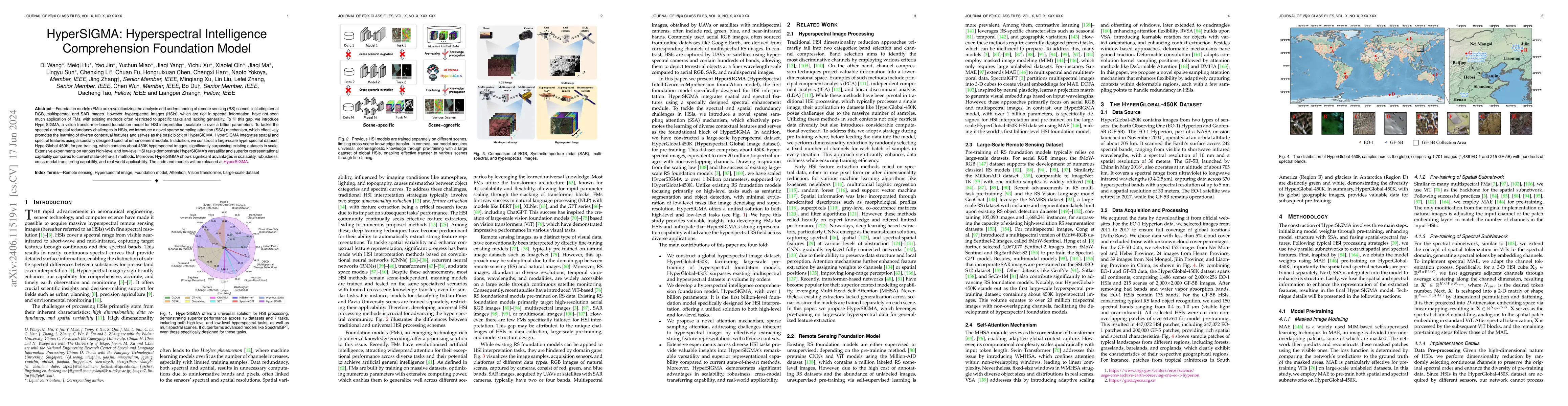
Foundation models (FMs) are revolutionizing the analysis and understanding of remote sensing (RS) scenes, including aerial RGB, multispectral, and SAR images. However, hyperspectral images (HSIs), whi...
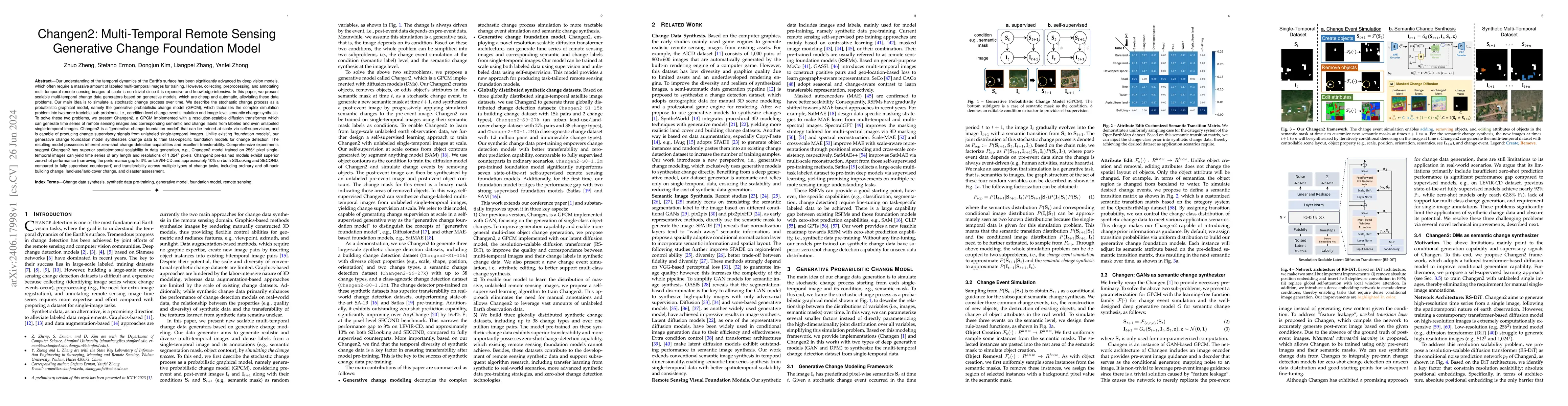
Our understanding of the temporal dynamics of the Earth's surface has been advanced by deep vision models, which often require lots of labeled multi-temporal images for training. However, collecting, ...
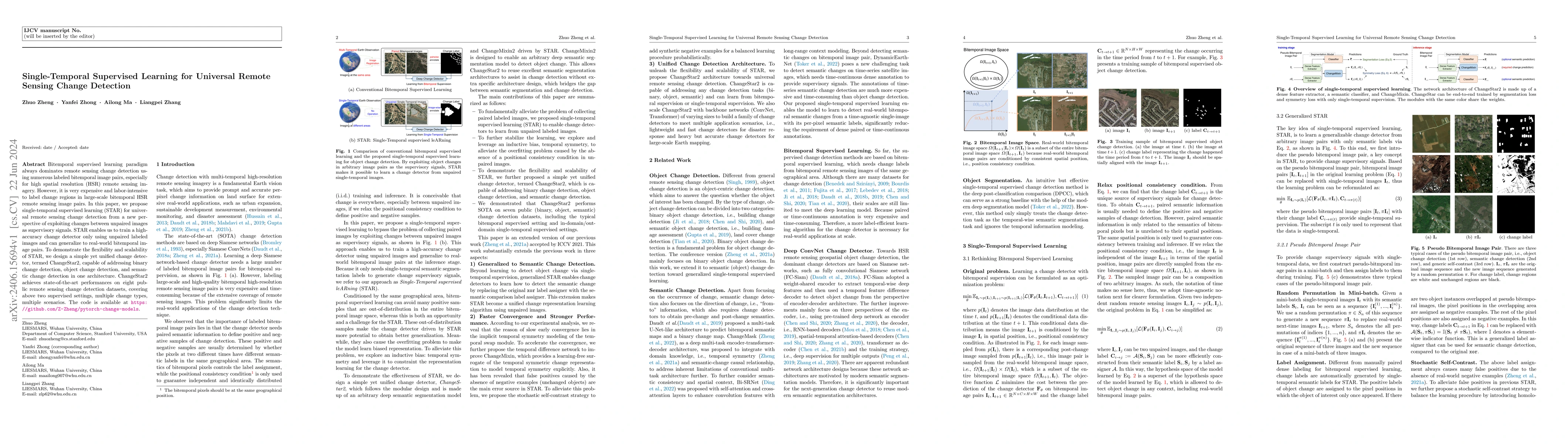
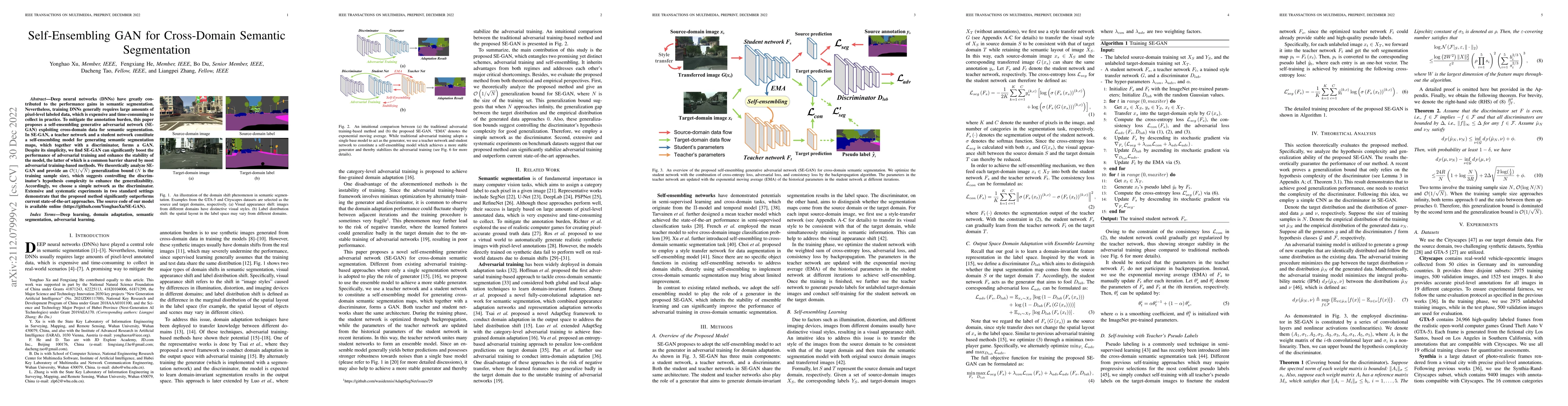
Bitemporal supervised learning paradigm always dominates remote sensing change detection using numerous labeled bitemporal image pairs, especially for high spatial resolution (HSR) remote sensing im...
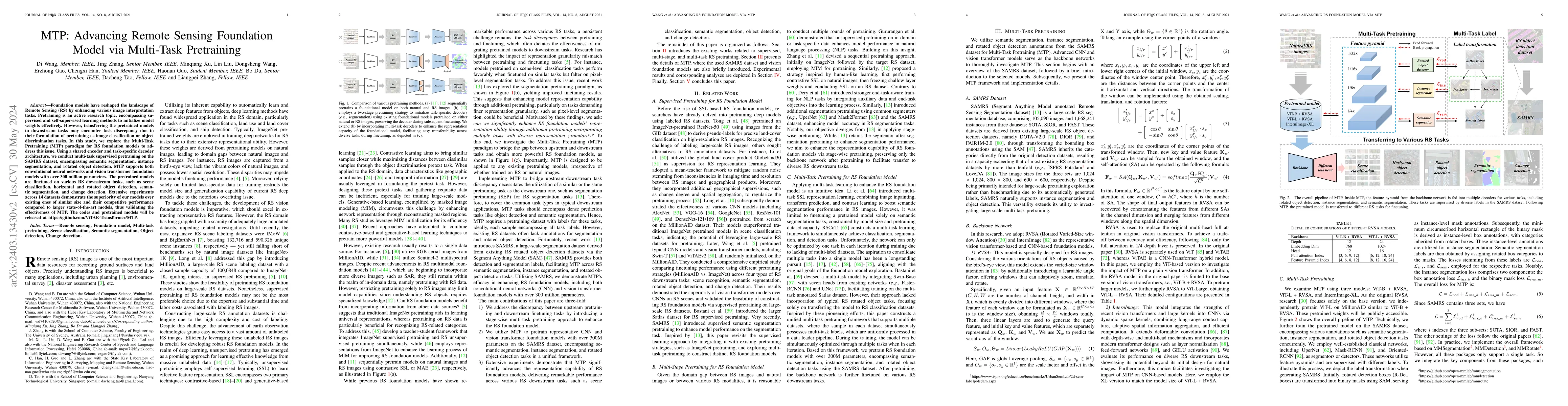
Foundation models have reshaped the landscape of Remote Sensing (RS) by enhancing various image interpretation tasks. Pretraining is an active research topic, encompassing supervised and self-superv...
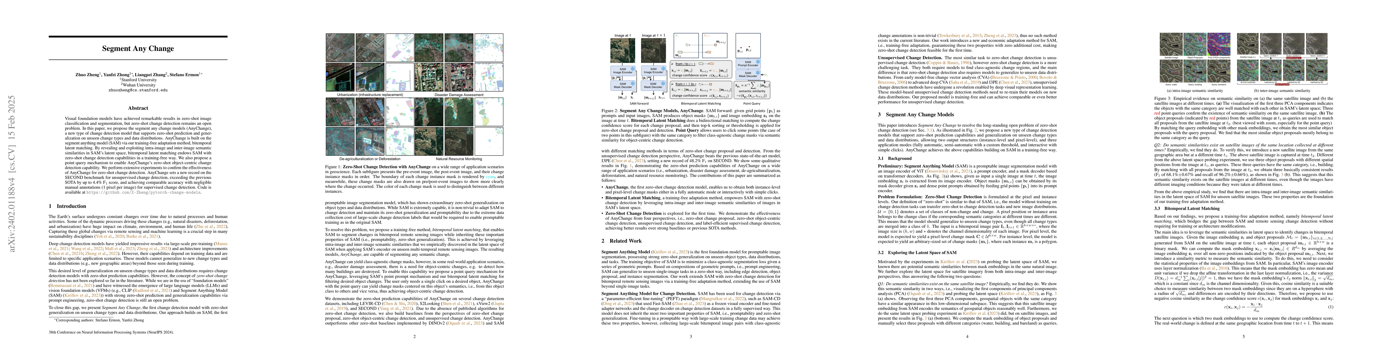
Visual foundation models have achieved remarkable results in zero-shot image classification and segmentation, but zero-shot change detection remains an open problem. In this paper, we propose the se...
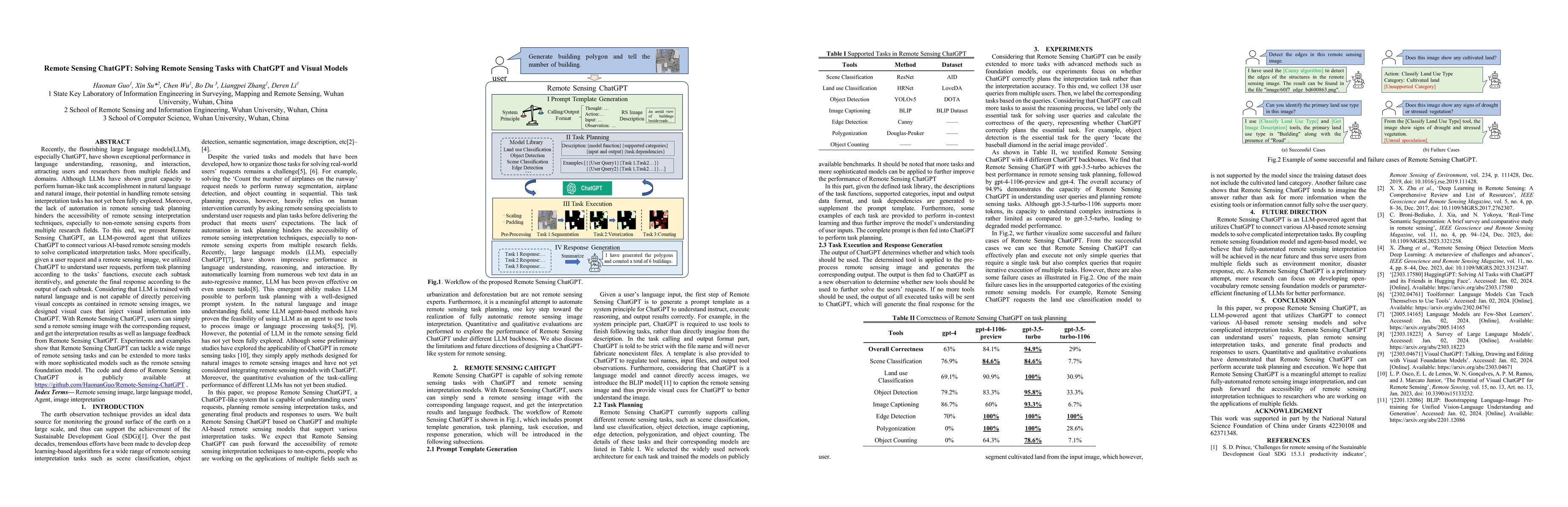
Recently, the flourishing large language models(LLM), especially ChatGPT, have shown exceptional performance in language understanding, reasoning, and interaction, attracting users and researchers f...
Recent efforts have witnessed remarkable progress in Satellite Video Super-Resolution (SVSR). However, most SVSR methods usually assume the degradation is fixed and known, e.g., bicubic downsampling...
Hyperspectral image super-resolution has attained widespread prominence to enhance the spatial resolution of hyperspectral images. However, convolution-based methods have encountered challenges in h...
Data collected by different modalities can provide a wealth of complementary information, such as hyperspectral image (HSI) to offer rich spectral-spatial properties, synthetic aperture radar (SAR) ...
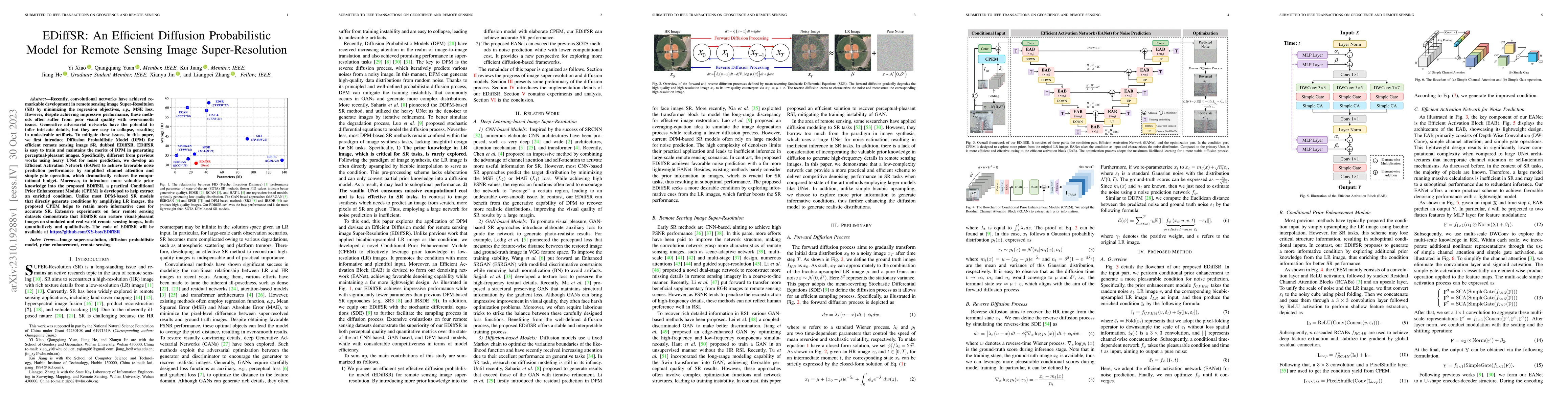
Recently, convolutional networks have achieved remarkable development in remote sensing image Super-Resoltuion (SR) by minimizing the regression objectives, e.g., MSE loss. However, despite achievin...
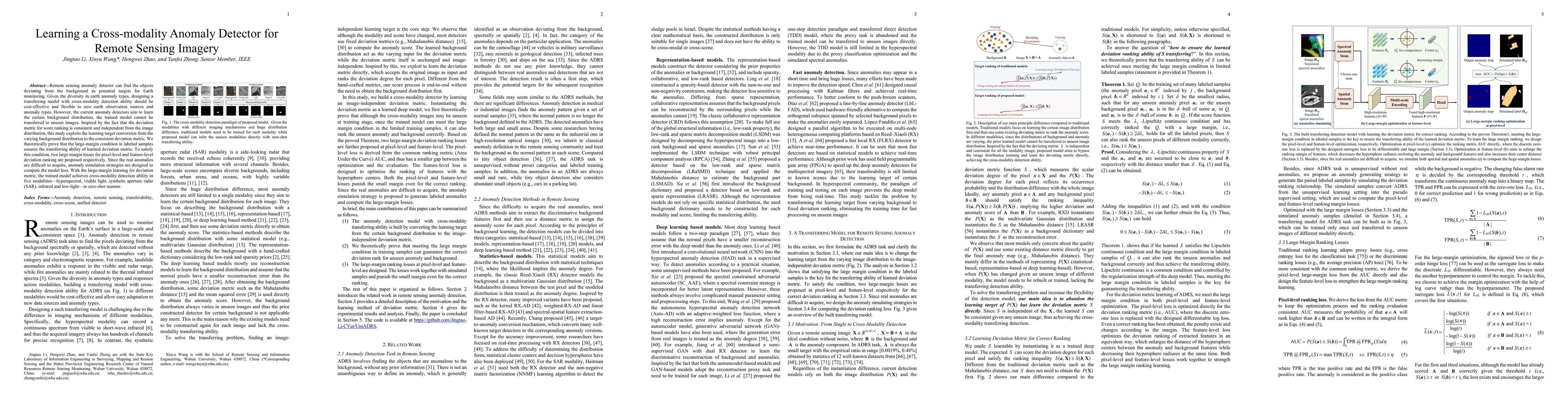
Remote sensing anomaly detector can find the objects deviating from the background as potential targets. Given the diversity in earth anomaly types, a unified anomaly detector across modalities and ...
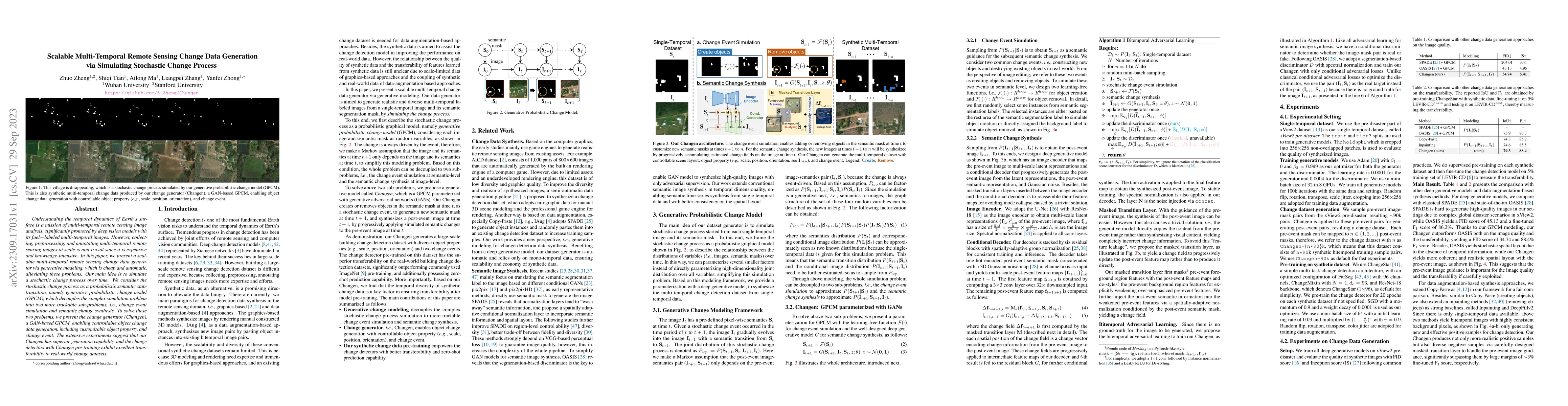
Understanding the temporal dynamics of Earth's surface is a mission of multi-temporal remote sensing image analysis, significantly promoted by deep vision models with its fuel -- labeled multi-tempo...
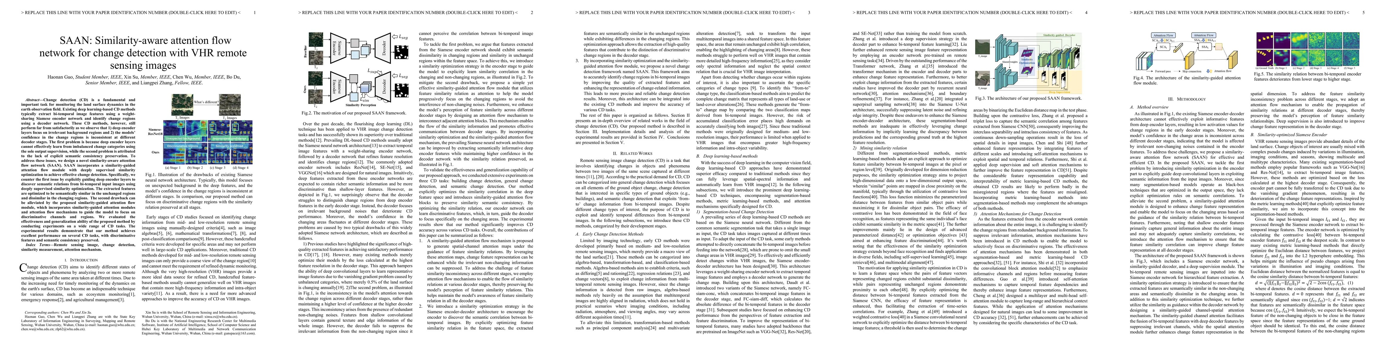
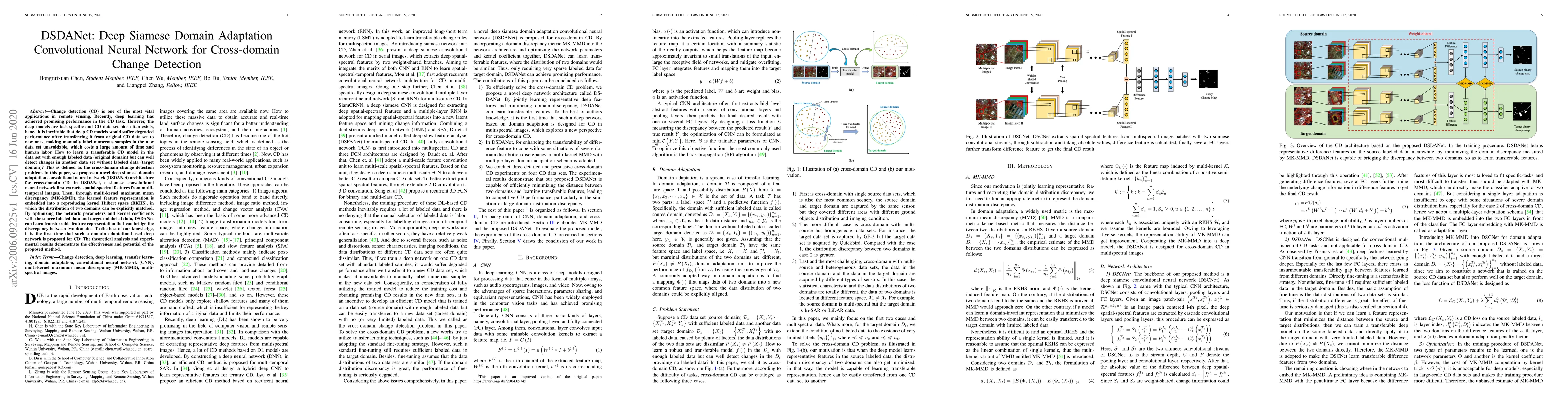
Change detection (CD) is a fundamental and important task for monitoring the land surface dynamics in the earth observation field. Existing deep learning-based CD methods typically extract bi-tempor...
Building extraction aims to segment building pixels from remote sensing images and plays an essential role in many applications, such as city planning and urban dynamic monitoring. Over the past few...
Buildings are the basic carrier of social production and human life; roads are the links that interconnect social networks. Building and road information has important application value in the front...
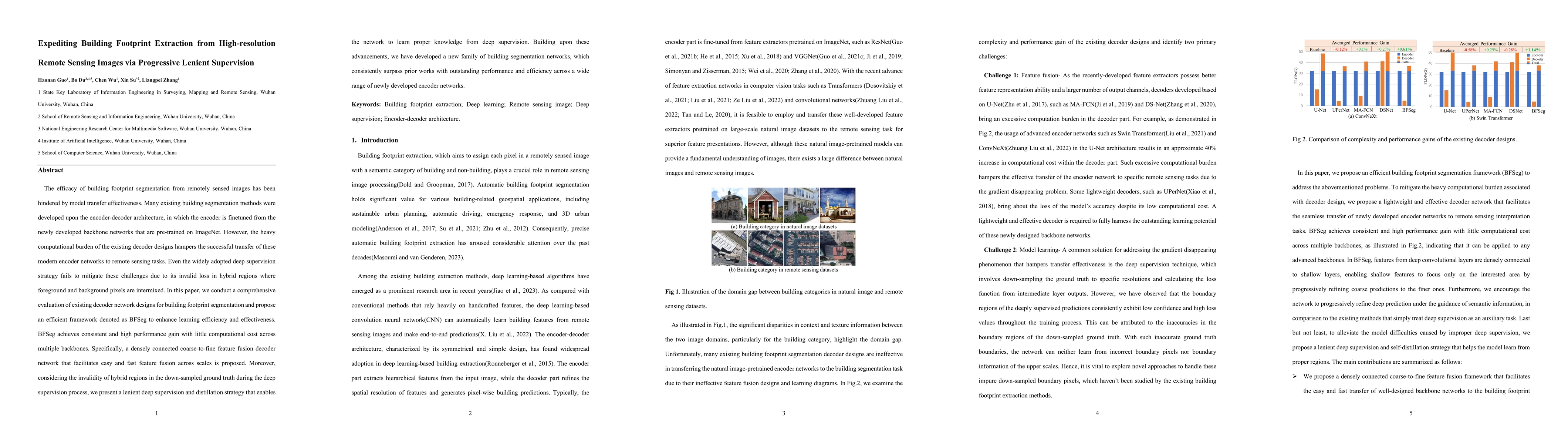
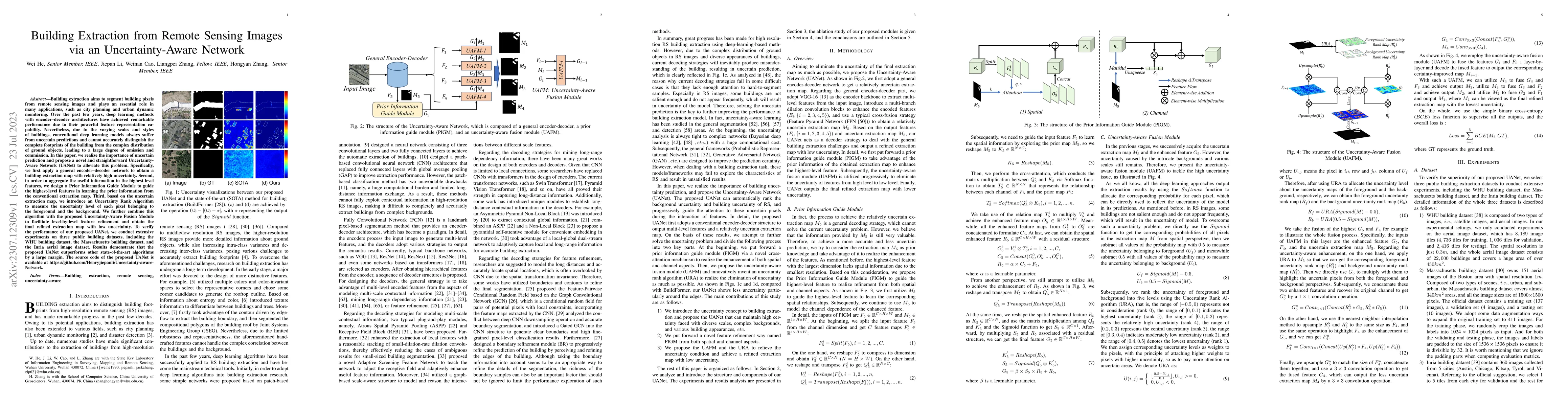
The efficacy of building footprint segmentation from remotely sensed images has been hindered by model transfer effectiveness. Many existing building segmentation methods were developed upon the enc...
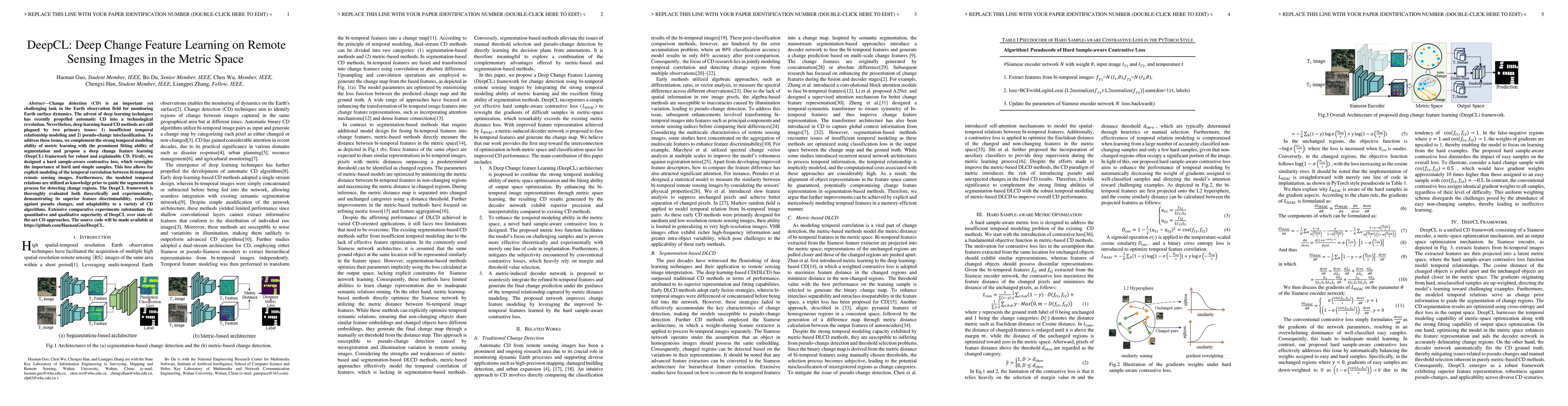
Change detection (CD) is an important yet challenging task in the Earth observation field for monitoring Earth surface dynamics. The advent of deep learning techniques has recently propelled automat...
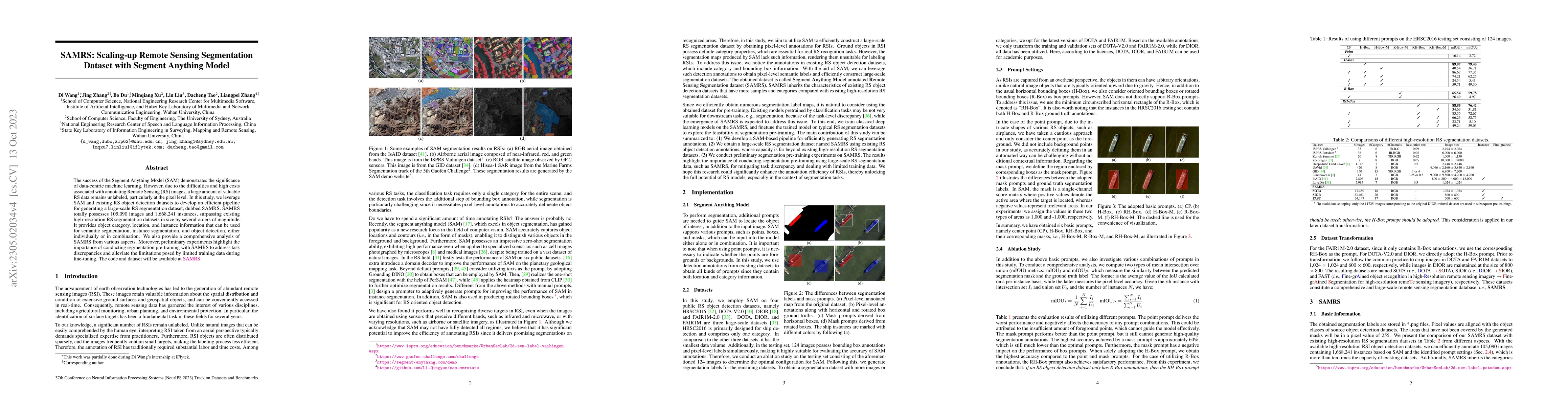
The success of the Segment Anything Model (SAM) demonstrates the significance of data-centric machine learning. However, due to the difficulties and high costs associated with annotating Remote Sens...
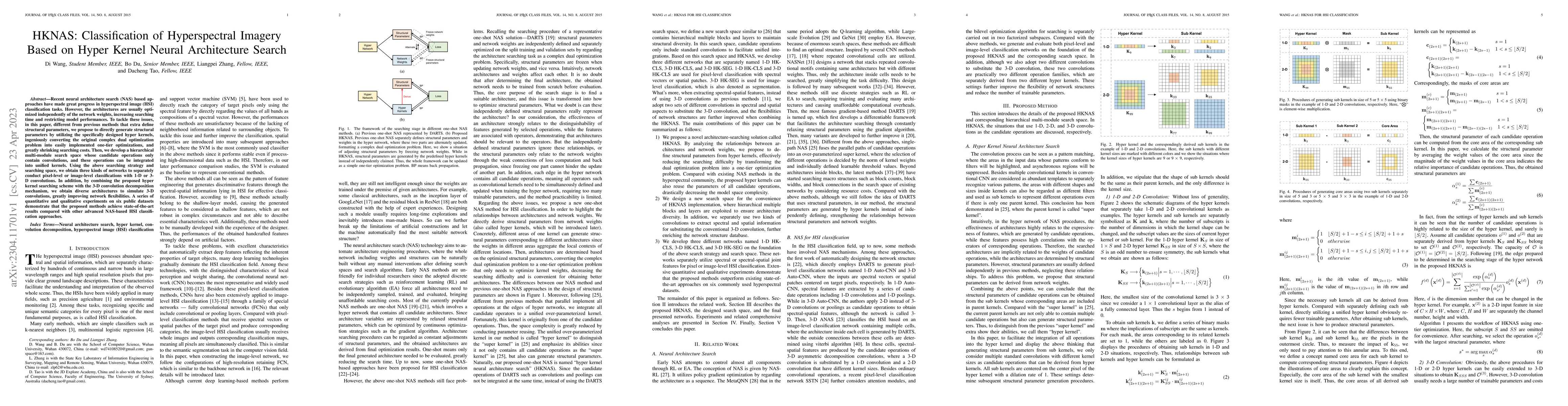
Recent neural architecture search (NAS) based approaches have made great progress in hyperspectral image (HSI) classification tasks. However, the architectures are usually optimized independently of...
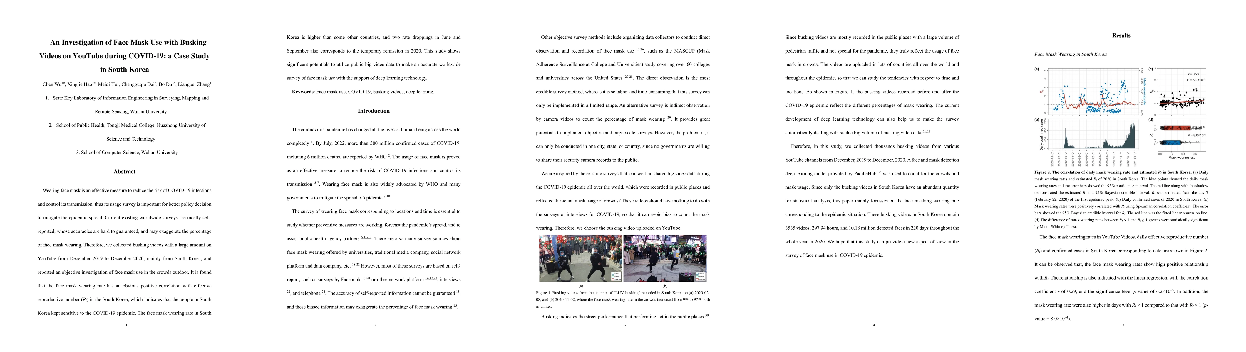
Wearing face mask is an effective measure to reduce the risk of COVID-19 infections and control its transmission, thus its usage survey is important for better policy decision to mitigate the epidem...
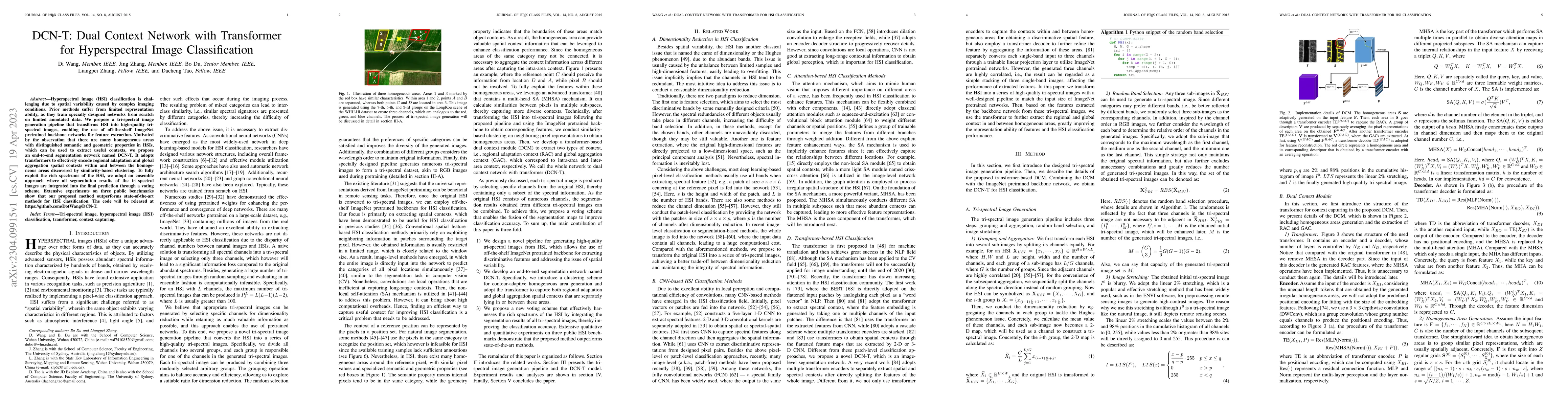
Hyperspectral image (HSI) classification is challenging due to spatial variability caused by complex imaging conditions. Prior methods suffer from limited representation ability, as they train speci...
High spectral resolution imagery of the Earth's surface enables users to monitor changes over time in fine-grained scale, playing an increasingly important role in agriculture, defense, and emergenc...
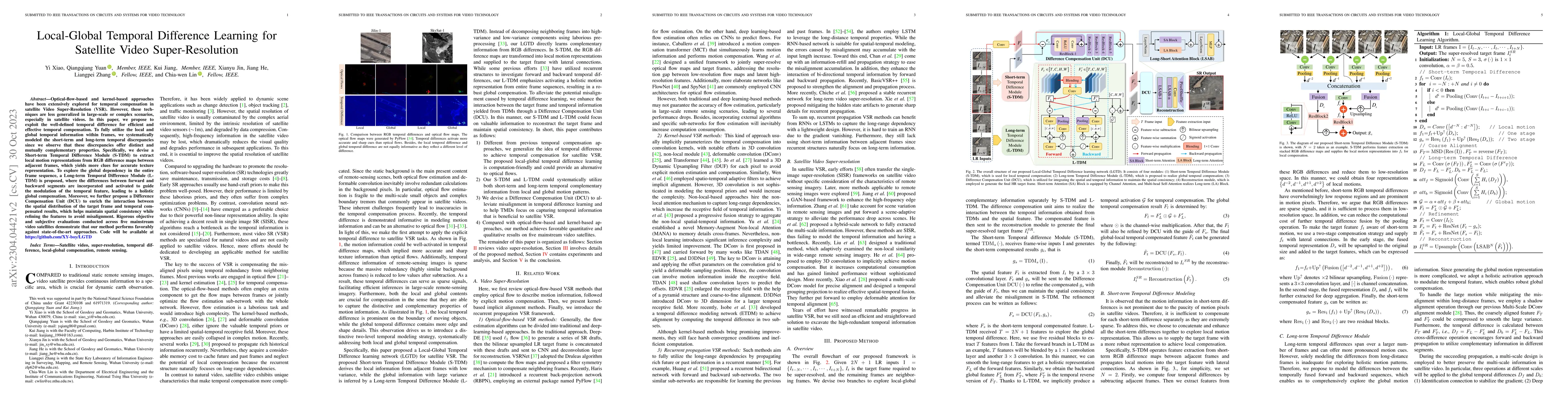
Optical-flow-based and kernel-based approaches have been extensively explored for temporal compensation in satellite Video Super-Resolution (VSR). However, these techniques are less generalized in l...
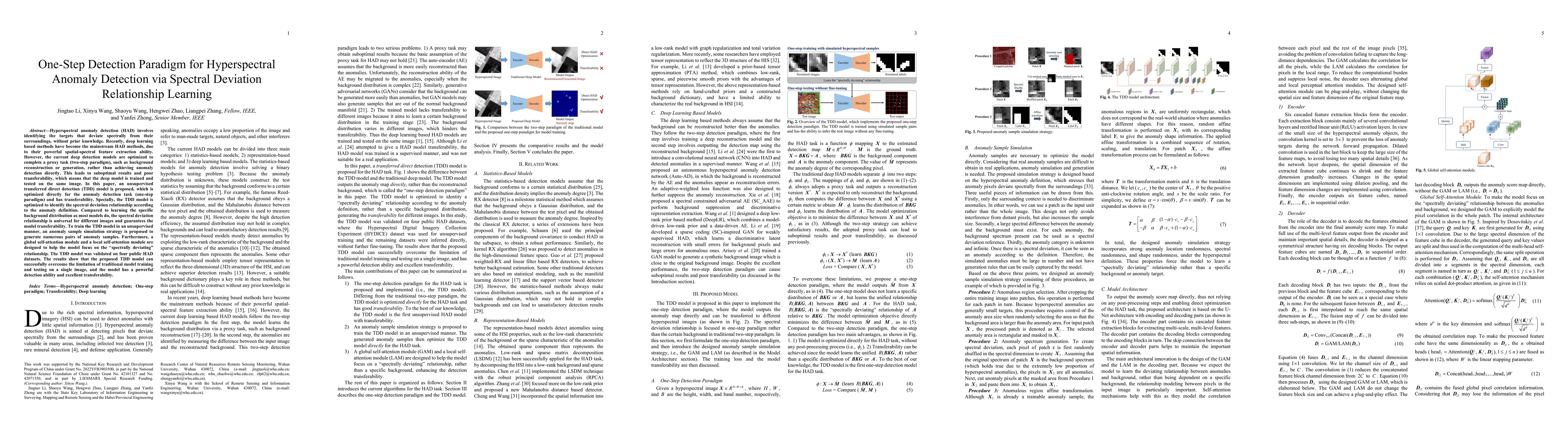
Hyperspectral anomaly detection (HAD) involves identifying the targets that deviate spectrally from their surroundings, without prior knowledge. Recently, deep learning based methods have become the...
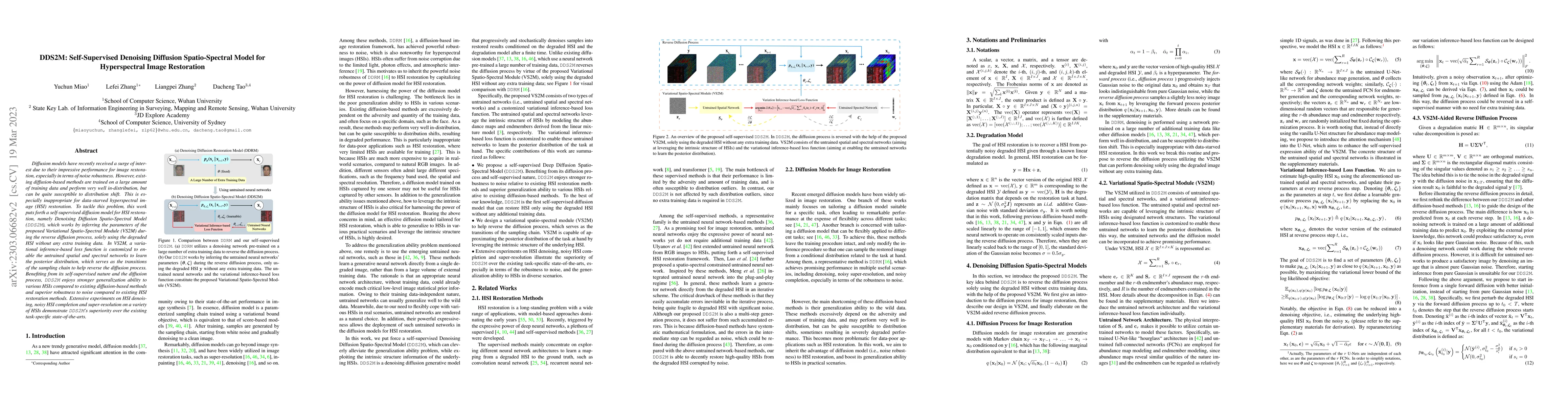
Diffusion models have recently received a surge of interest due to their impressive performance for image restoration, especially in terms of noise robustness. However, existing diffusion-based meth...
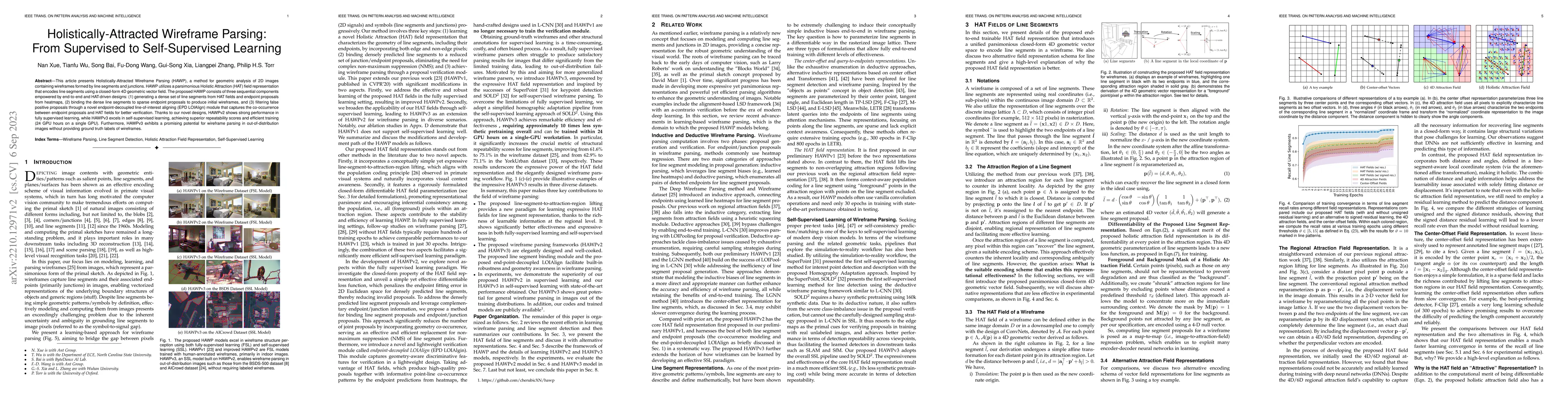
This article presents Holistically-Attracted Wireframe Parsing (HAWP), a method for geometric analysis of 2D images containing wireframes formed by line segments and junctions. HAWP utilizes a parsi...
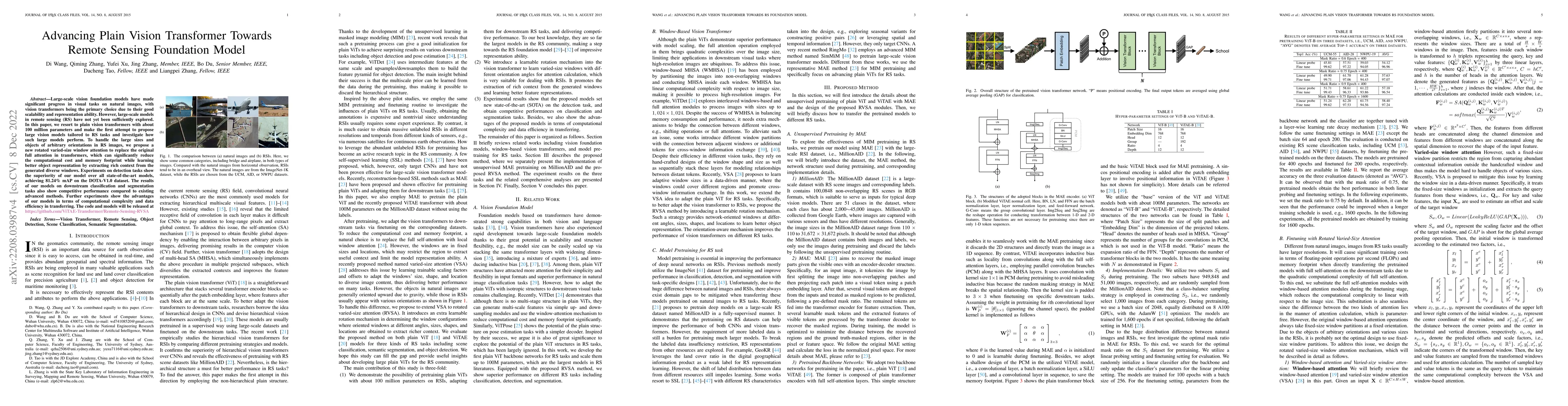
Large-scale vision foundation models have made significant progress in visual tasks on natural images, with vision transformers being the primary choice due to their good scalability and representat...
The fast development of self-supervised learning lowers the bar learning feature representation from massive unlabeled data and has triggered a series of research on change detection of remote sensi...
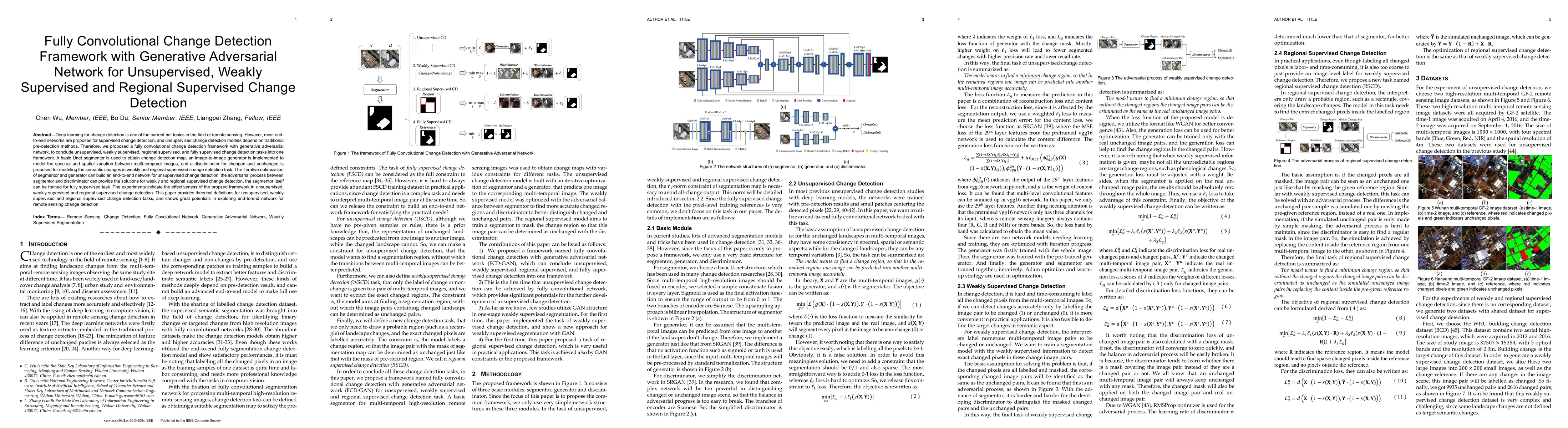
Deep learning for change detection is one of the current hot topics in the field of remote sensing. However, most end-to-end networks are proposed for supervised change detection, and unsupervised c...
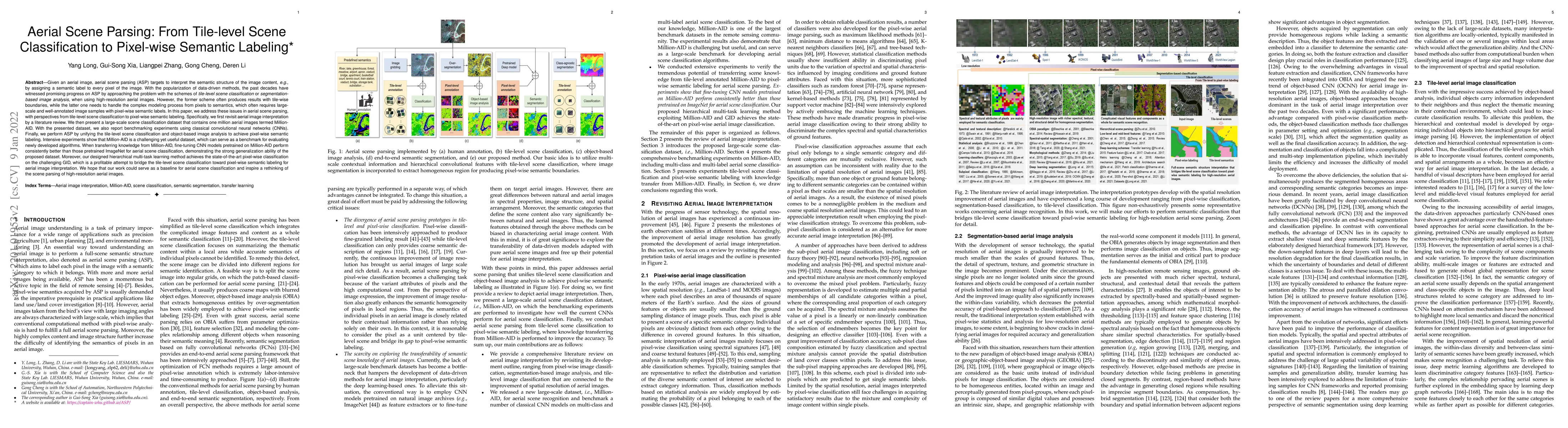
Given an aerial image, aerial scene parsing (ASP) targets to interpret the semantic structure of the image content, e.g., by assigning a semantic label to every pixel of the image. With the populari...
Deep neural networks (DNNs) have greatly contributed to the performance gains in semantic segmentation. Nevertheless, training DNNs generally requires large amounts of pixel-level labeled data, whic...
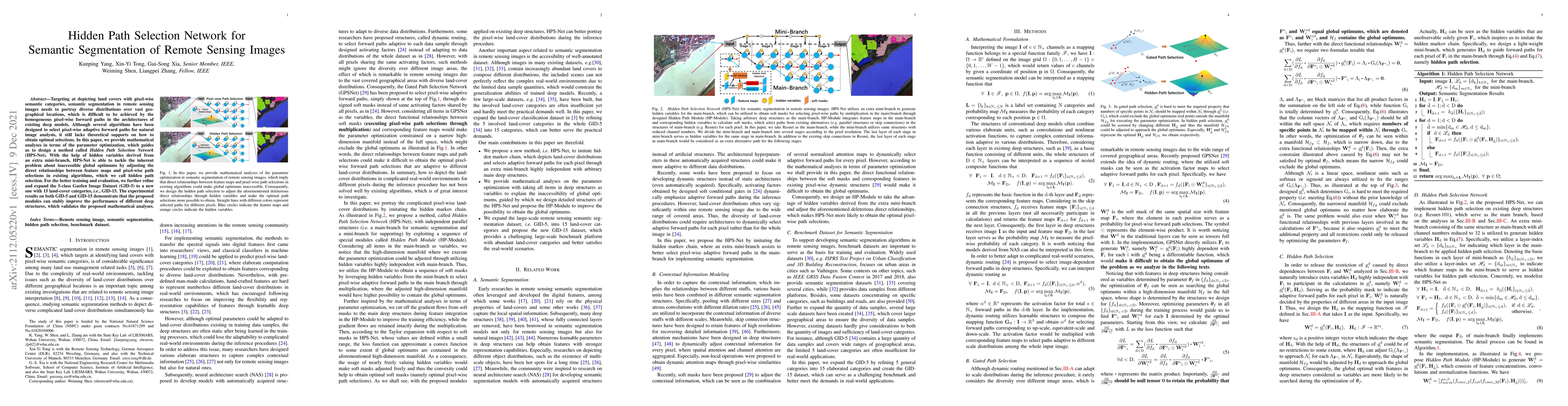
Targeting at depicting land covers with pixel-wise semantic categories, semantic segmentation in remote sensing images needs to portray diverse distributions over vast geographical locations, which ...
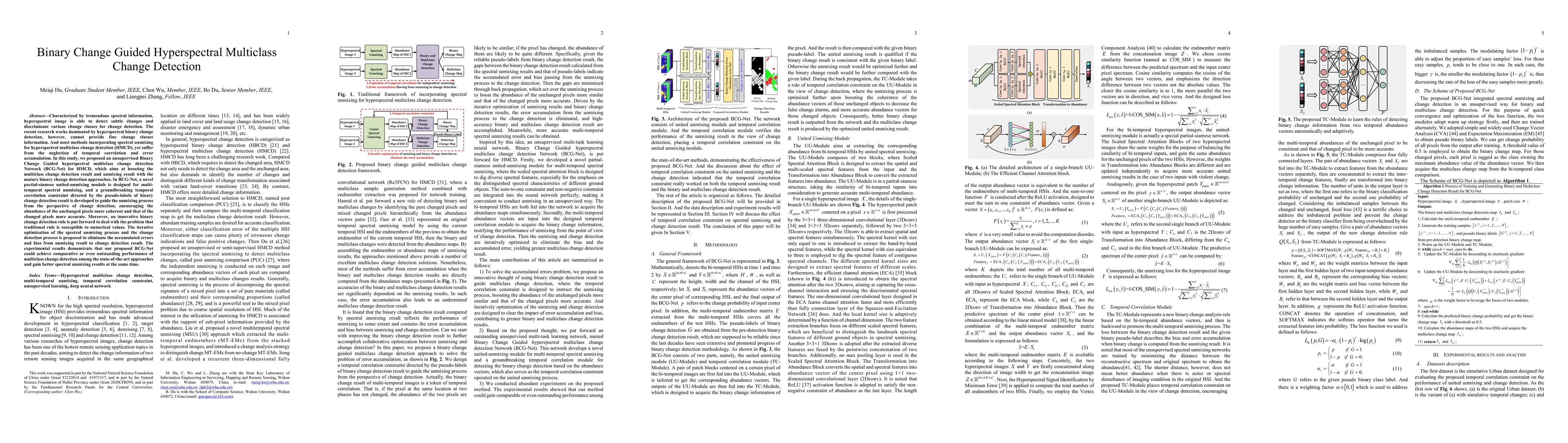
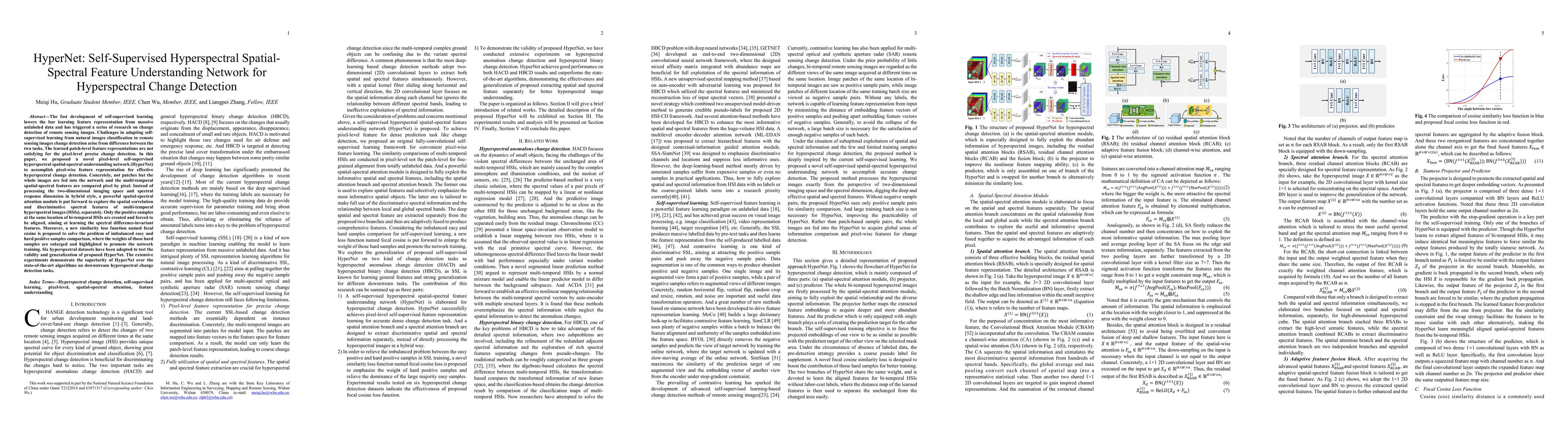
Characterized by tremendous spectral information, hyperspectral image is able to detect subtle changes and discriminate various change classes for change detection. The recent research works dominat...
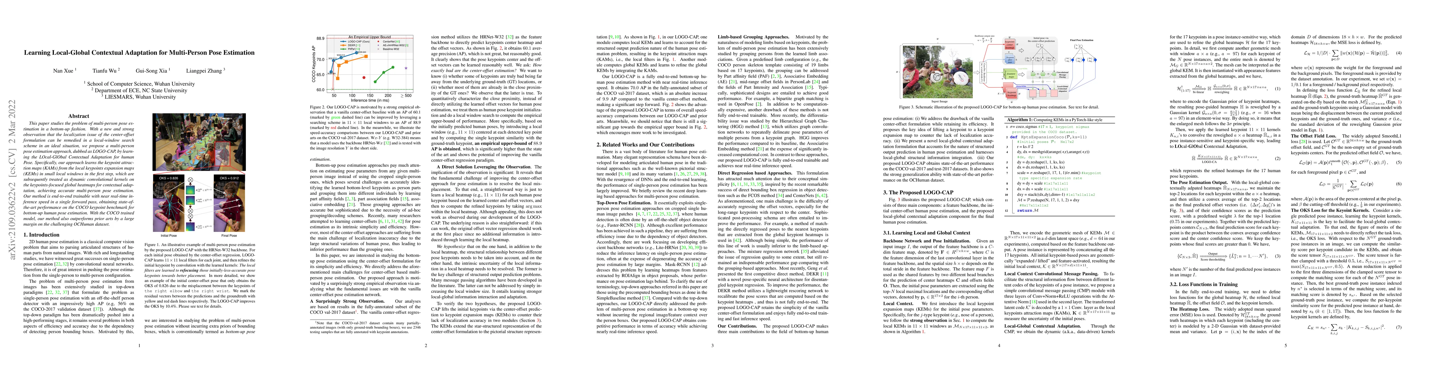
This paper studies the problem of multi-person pose estimation in a bottom-up fashion. With a new and strong observation that the localization issue of the center-offset formulation can be remedied ...
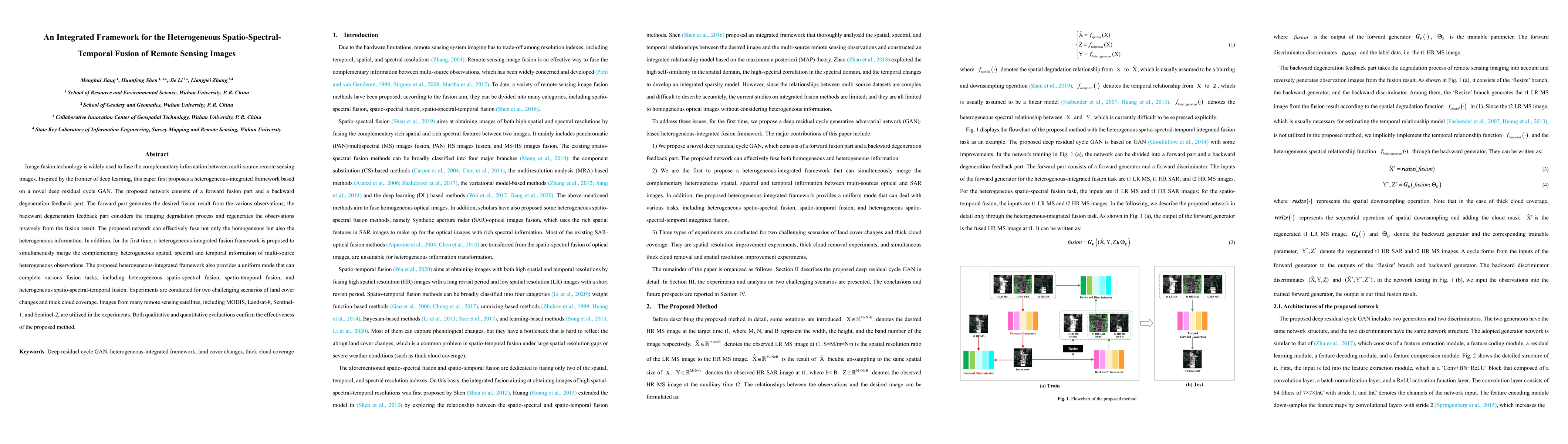
Image fusion technology is widely used to fuse the complementary information between multi-source remote sensing images. Inspired by the frontier of deep learning, this paper first proposes a hetero...
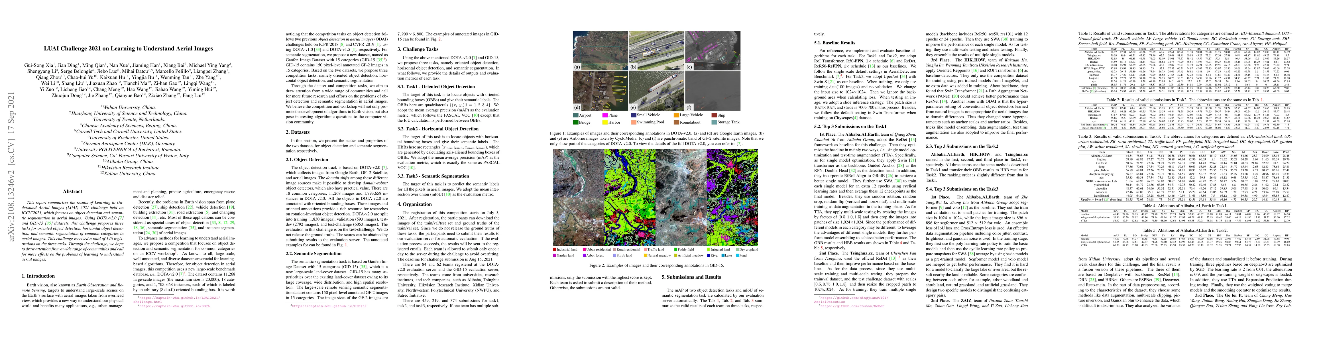
This report summarizes the results of Learning to Understand Aerial Images (LUAI) 2021 challenge held on ICCV 2021, which focuses on object detection and semantic segmentation in aerial images. Usin...
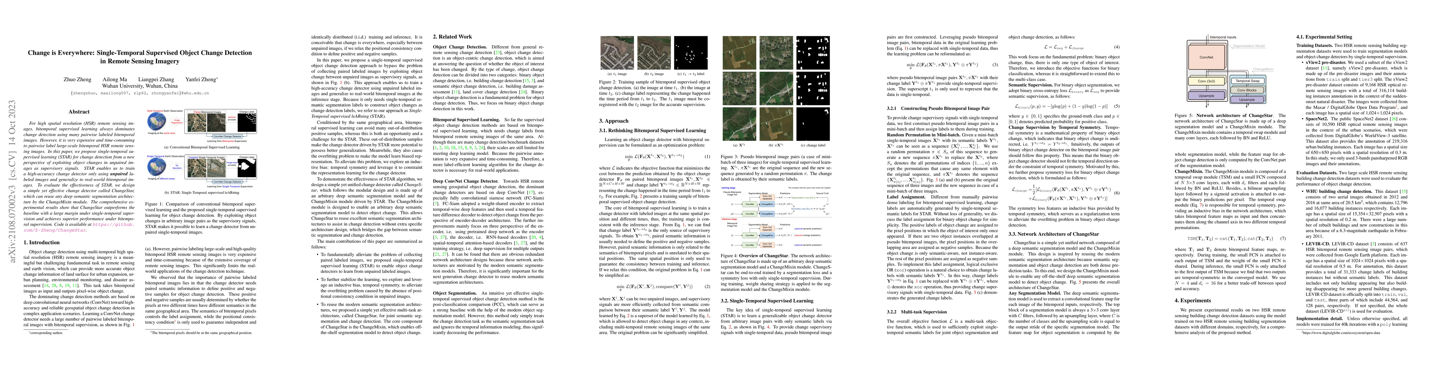
For high spatial resolution (HSR) remote sensing images, bitemporal supervised learning always dominates change detection using many pairwise labeled bitemporal images. However, it is very expensive...
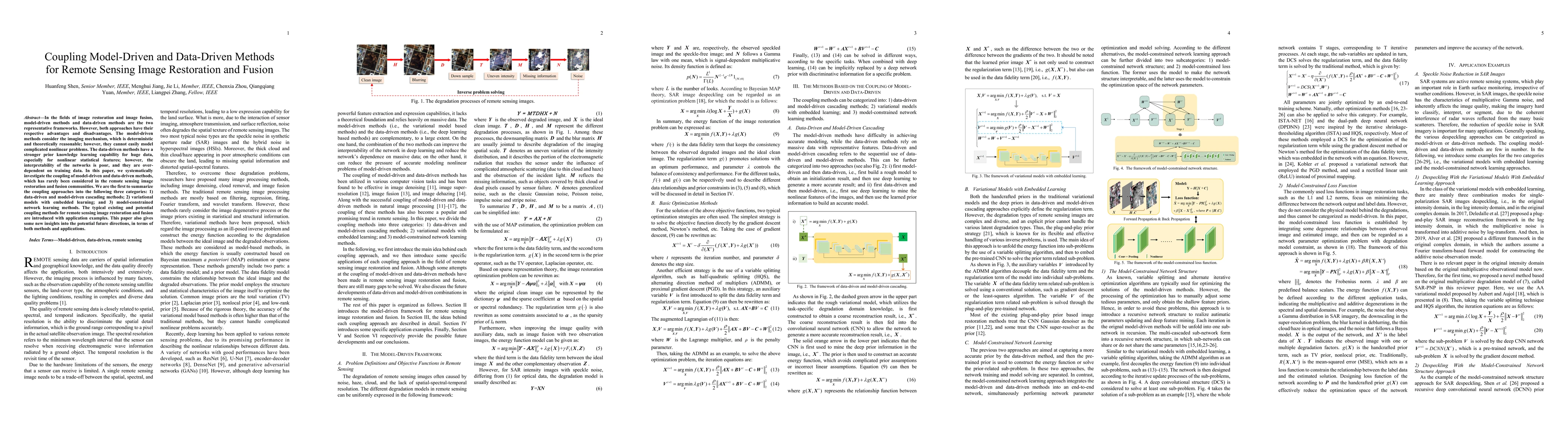
In the fields of image restoration and image fusion, model-driven methods and data-driven methods are the two representative frameworks. However, both approaches have their respective advantages and...
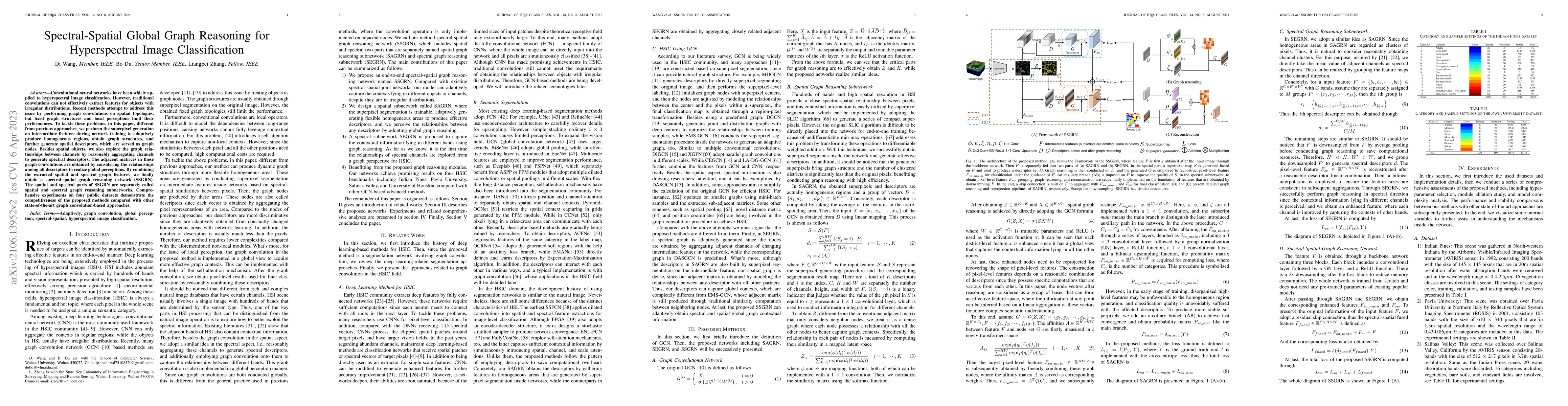
Convolutional neural networks have been widely applied to hyperspectral image classification. However, traditional convolutions can not effectively extract features for objects with irregular distri...
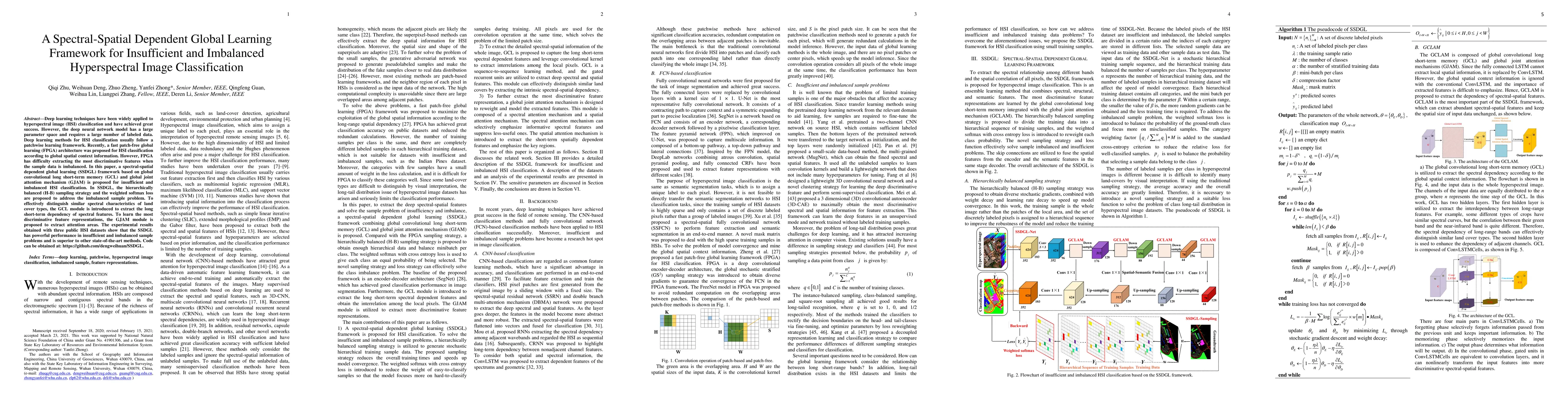
Deep learning techniques have been widely applied to hyperspectral image (HSI) classification and have achieved great success. However, the deep neural network model has a large parameter space and ...
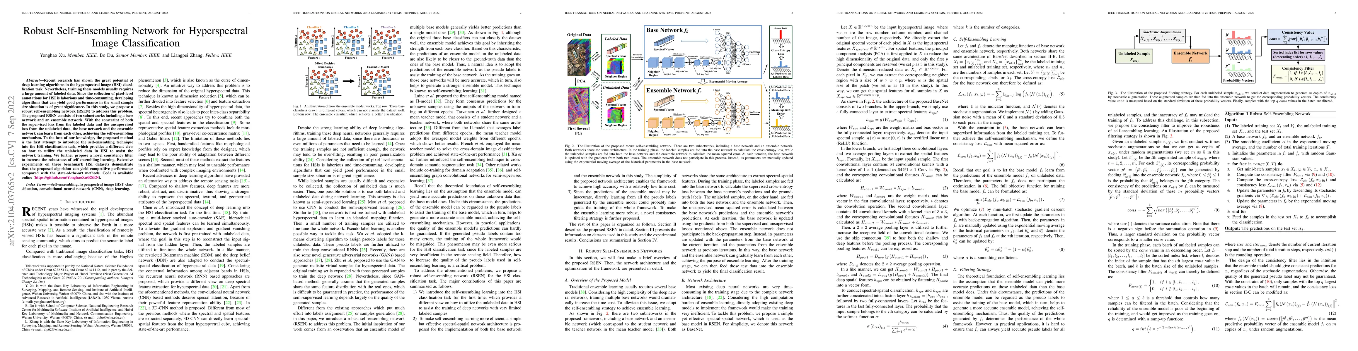
Recent research has shown the great potential of deep learning algorithms in the hyperspectral image (HSI) classification task. Nevertheless, training these models usually requires a large amount of...
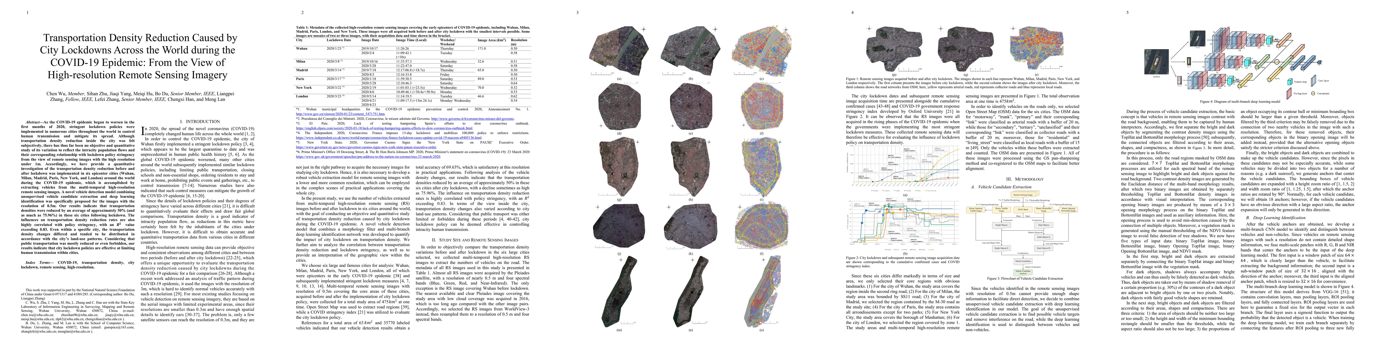
As the COVID-19 epidemic began to worsen in the first months of 2020, stringent lockdown policies were implemented in numerous cities throughout the world to control human transmission and mitigate ...
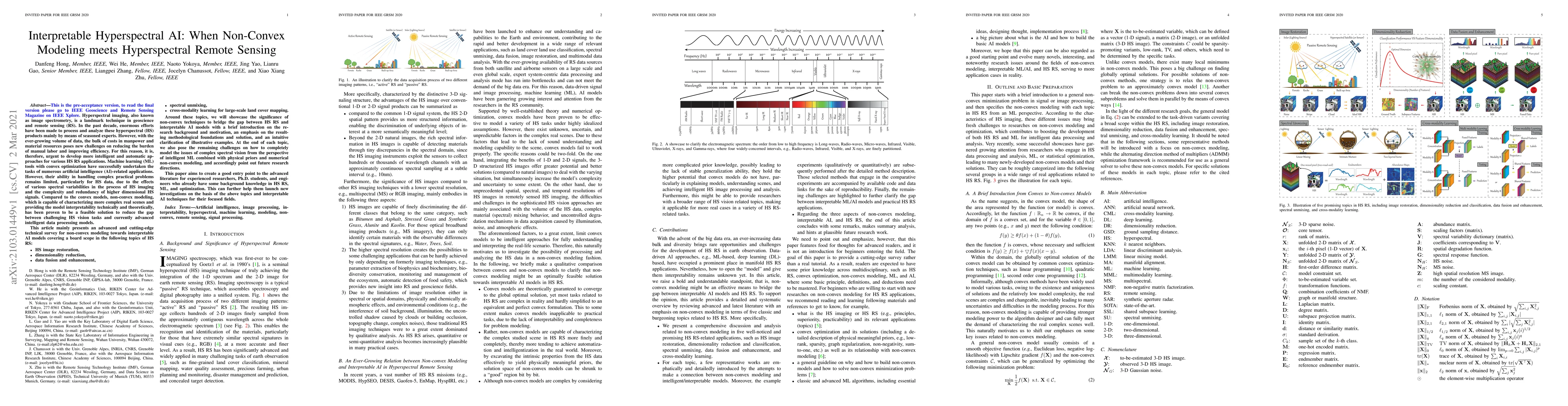
Hyperspectral imaging, also known as image spectrometry, is a landmark technique in geoscience and remote sensing (RS). In the past decade, enormous efforts have been made to process and analyze the...
Change detection, which aims to distinguish surface changes based on bi-temporal images, plays a vital role in ecological protection and urban planning. Since high resolution (HR) images cannot be t...
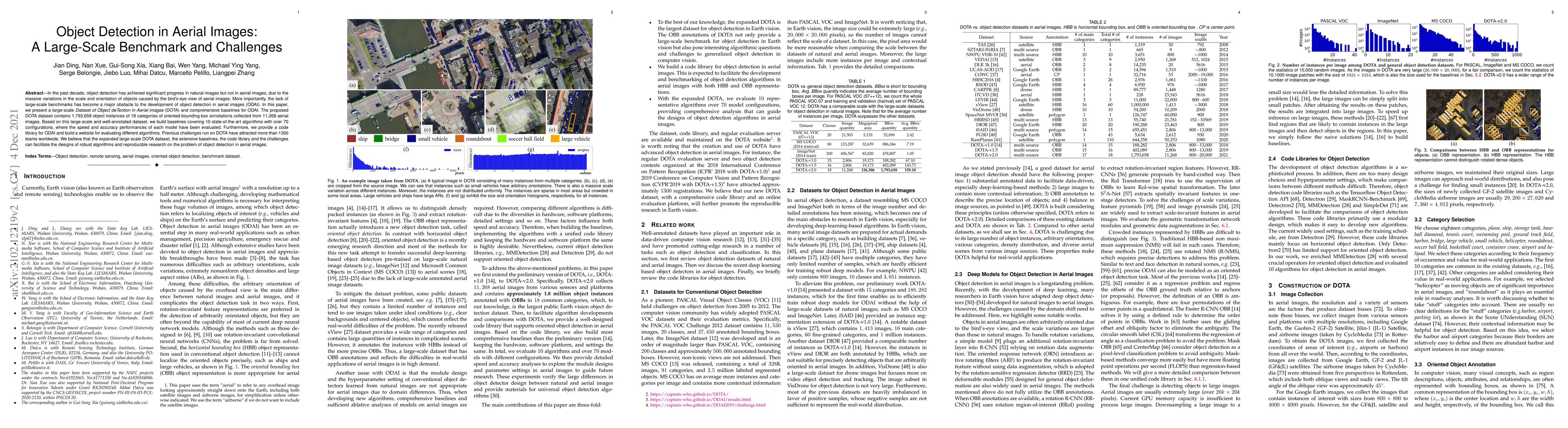
In the past decade, object detection has achieved significant progress in natural images but not in aerial images, due to the massive variations in the scale and orientation of objects caused by the...
The applications of Normalized Difference Vegetation Index (NDVI) time-series data are inevitably hampered by cloud-induced gaps and noise. Although numerous reconstruction methods have been develop...
Deep learning techniques have provided significant improvements in hyperspectral image (HSI) classification. The current deep learning based HSI classifiers follow a patch-based learning framework b...
With the hyperspectral imaging technology, hyperspectral data provides abundant spectral information and plays a more important role in geological survey, vegetation analysis and military reconnaiss...
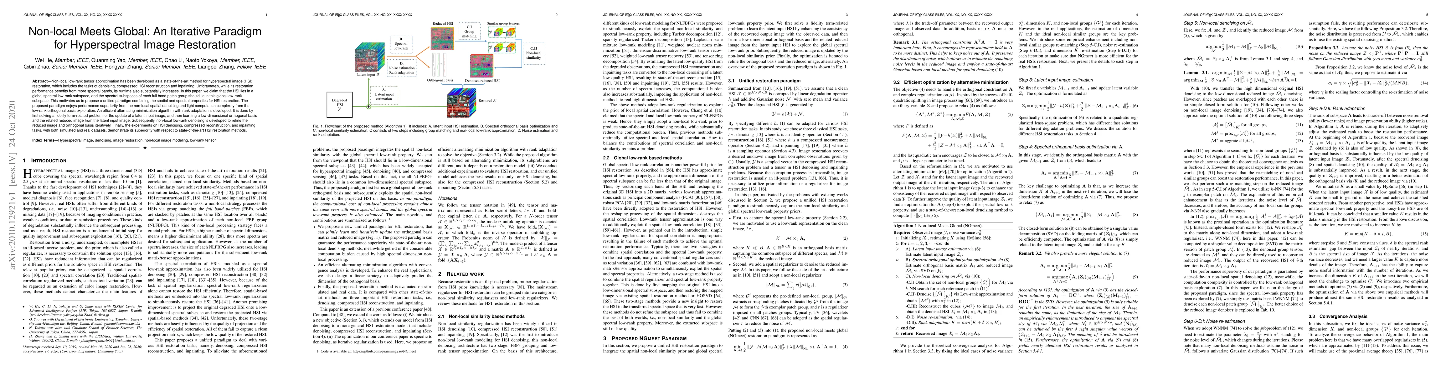
Non-local low-rank tensor approximation has been developed as a state-of-the-art method for hyperspectral image (HSI) restoration, which includes the tasks of denoising, compressed HSI reconstructio...
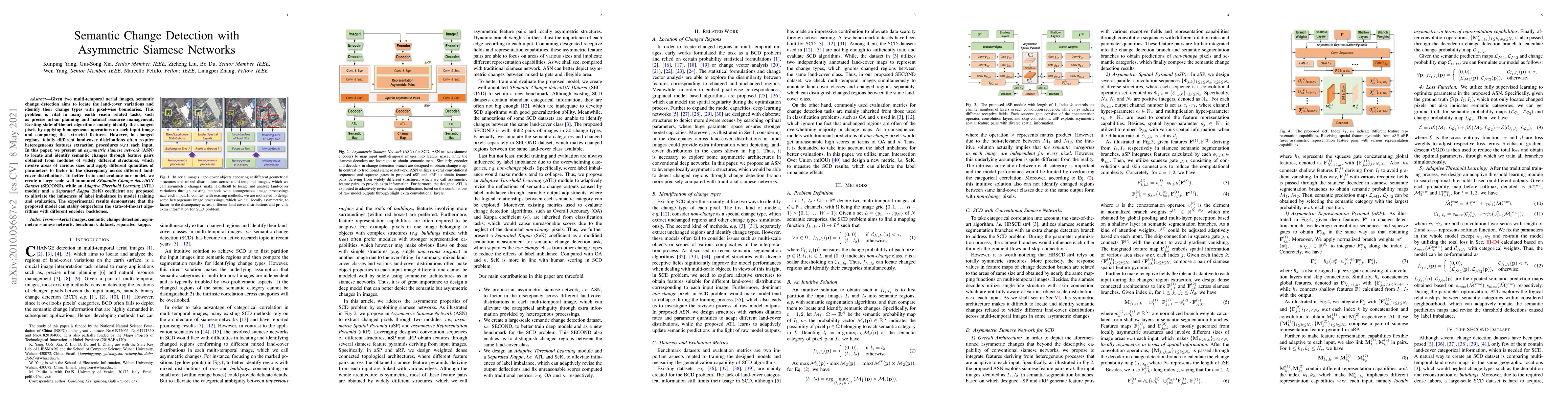
Given two multi-temporal aerial images, semantic change detection aims to locate the land-cover variations and identify their change types with pixel-wise boundaries. This problem is vital in many e...
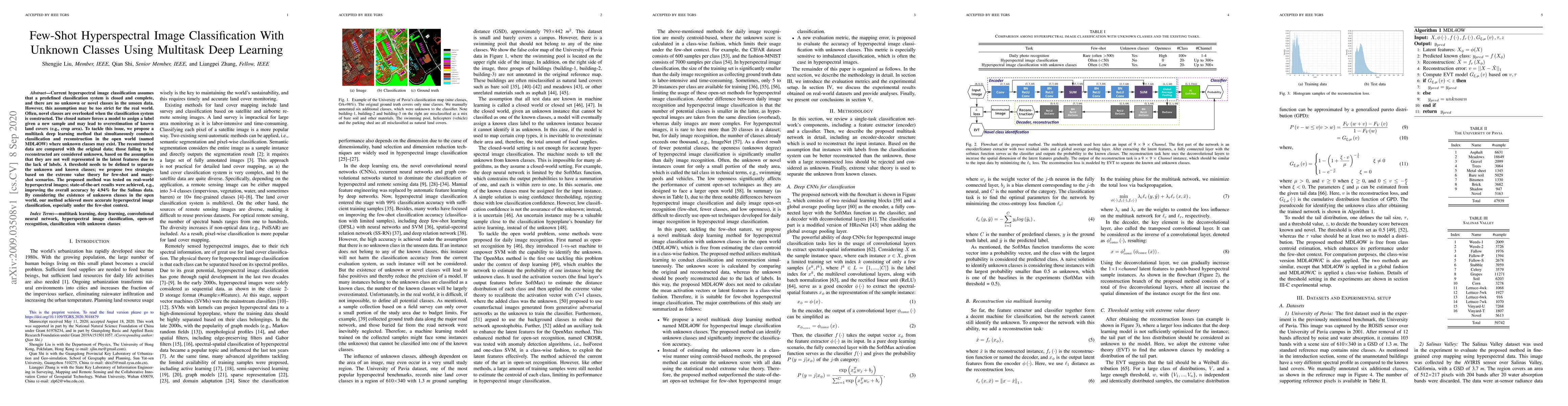
Current hyperspectral image classification assumes that a predefined classification system is closed and complete, and there are no unknown or novel classes in the unseen data. However, this assumpt...
Change detection (CD) is one of the most vital applications in remote sensing. Recently, deep learning has achieved promising performance in the CD task. However, the deep models are task-specific a...
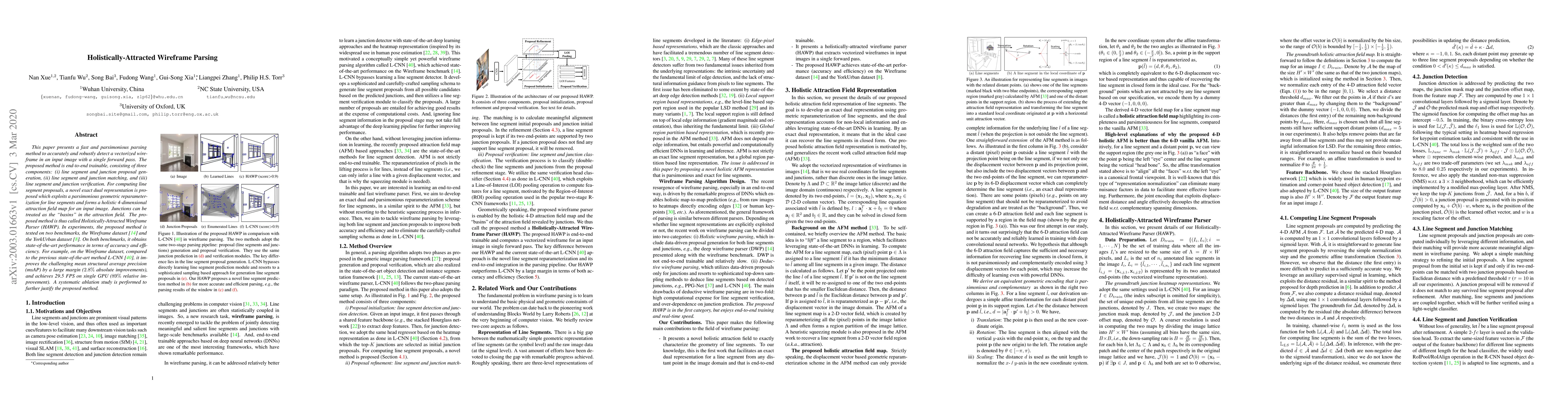
This paper presents a fast and parsimonious parsing method to accurately and robustly detect a vectorized wireframe in an input image with a single forward pass. The proposed method is end-to-end tr...
Air temperature (Ta) is an essential climatological component that controls and influences various earth surface processes. In this study, we make the first attempt to employ deep learning for Ta ma...
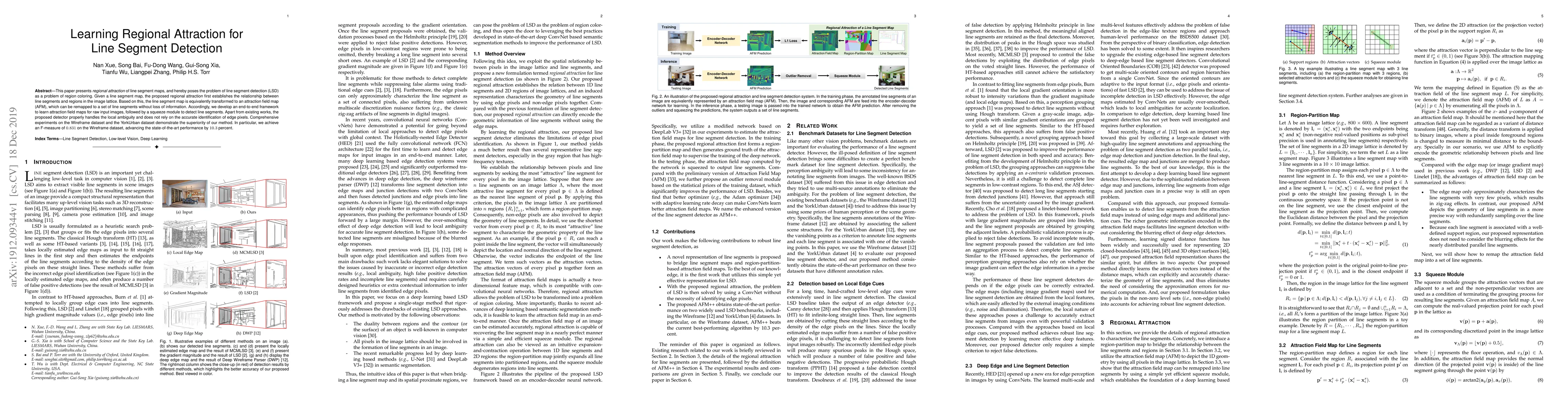
This paper presents regional attraction of line segment maps, and hereby poses the problem of line segment detection (LSD) as a problem of region coloring. Given a line segment map, the proposed reg...
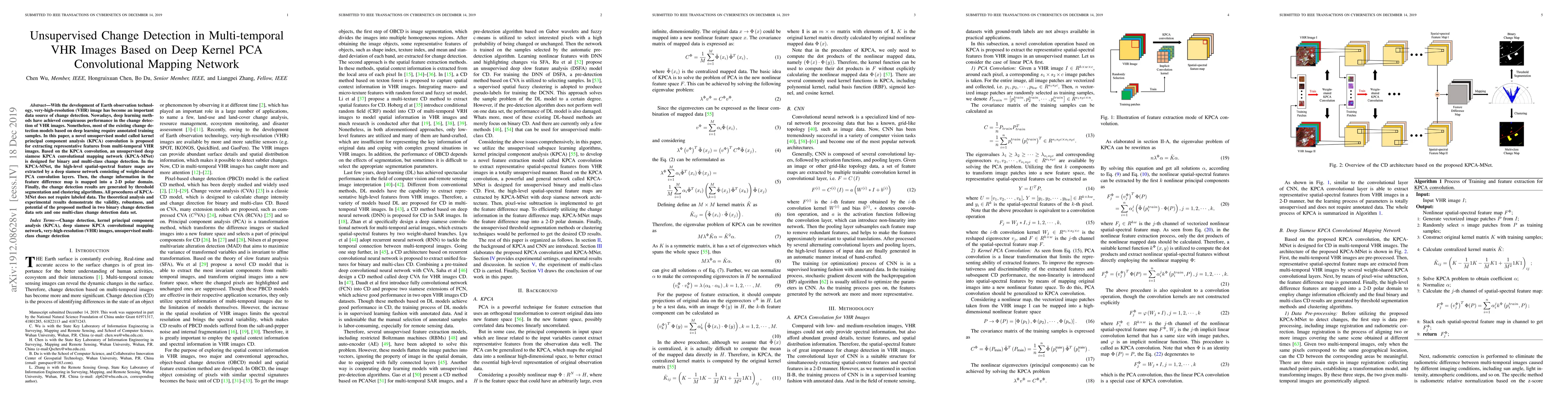
With the development of Earth observation technology, very-high-resolution (VHR) image has become an important data source of change detection. Nowadays, deep learning methods have achieved conspicu...
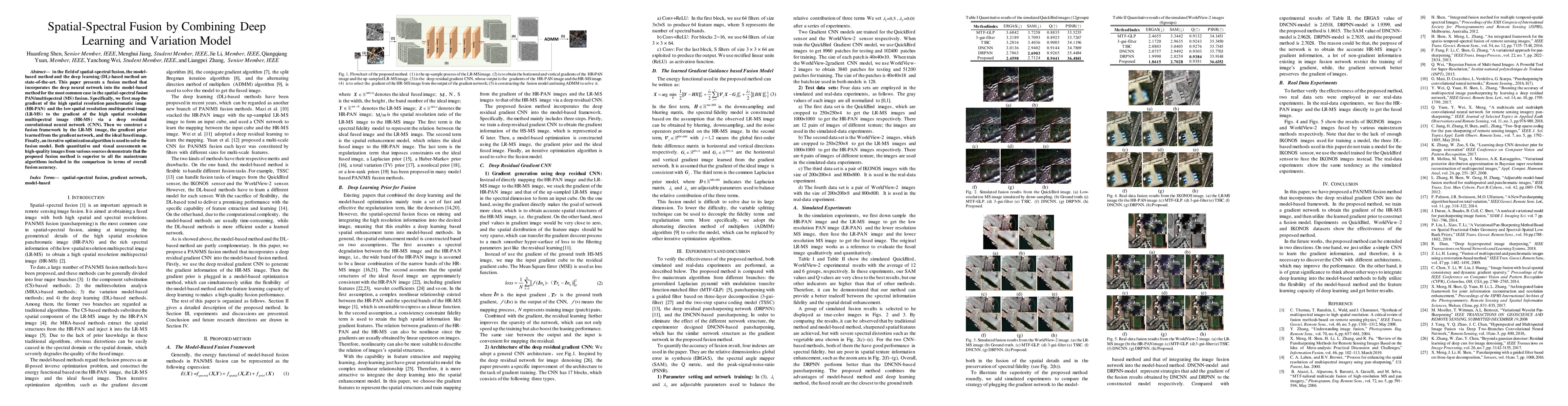
In the field of spatial-spectral fusion, the model-based method and the deep learning (DL)-based method are state-of-the-art. This paper presents a fusion method that incorporates the deep neural ne...
In recent years, large amount of high spatial-resolution remote sensing (HRRS) images are available for land-cover mapping. However, due to the complex information brought by the increased spatial r...
Satellite image time series (SITS) data provides continuous observations over time, allowing for the tracking of vegetation changes and growth patterns throughout the seasons and years. Numerous deep ...
Transformer has achieved satisfactory results in the field of hyperspectral image (HSI) classification. However, existing Transformer models face two key challenges when dealing with HSI scenes charac...
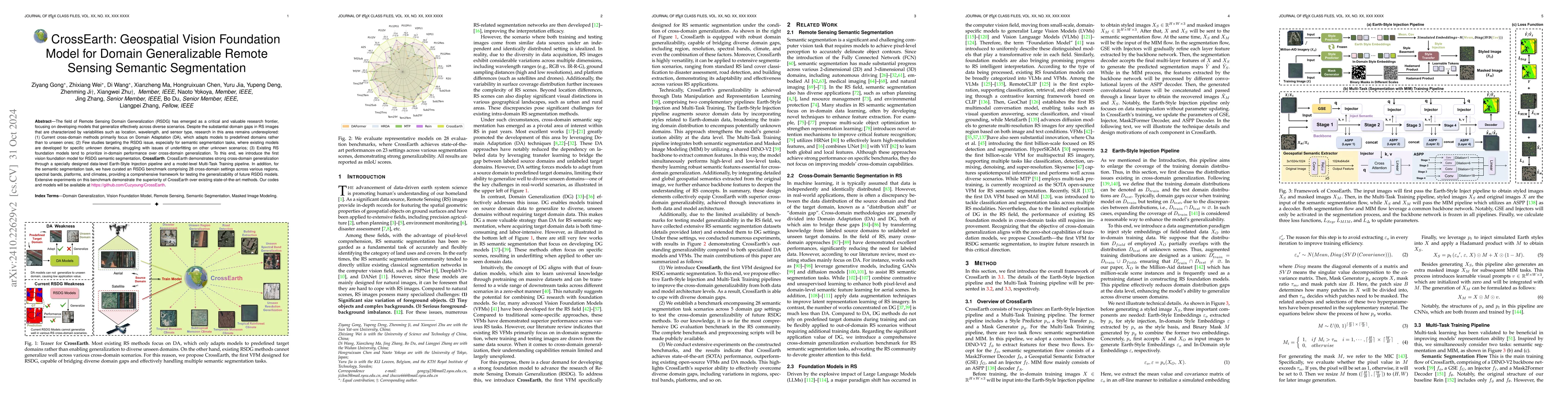
The field of Remote Sensing Domain Generalization (RSDG) has emerged as a critical and valuable research frontier, focusing on developing models that generalize effectively across diverse scenarios. D...
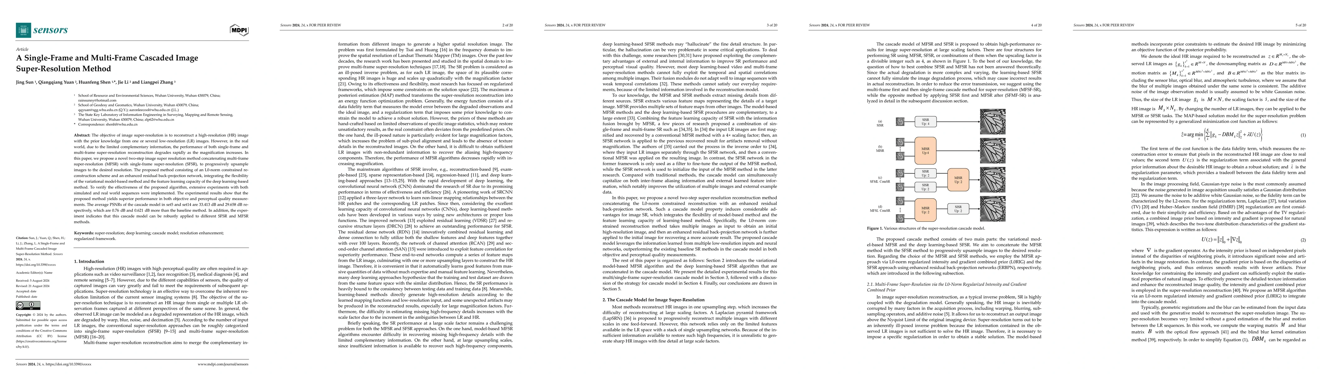
The objective of image super-resolution is to reconstruct a high-resolution (HR) image with the prior knowledge from one or several low-resolution (LR) images. However, in the real world, due to the l...
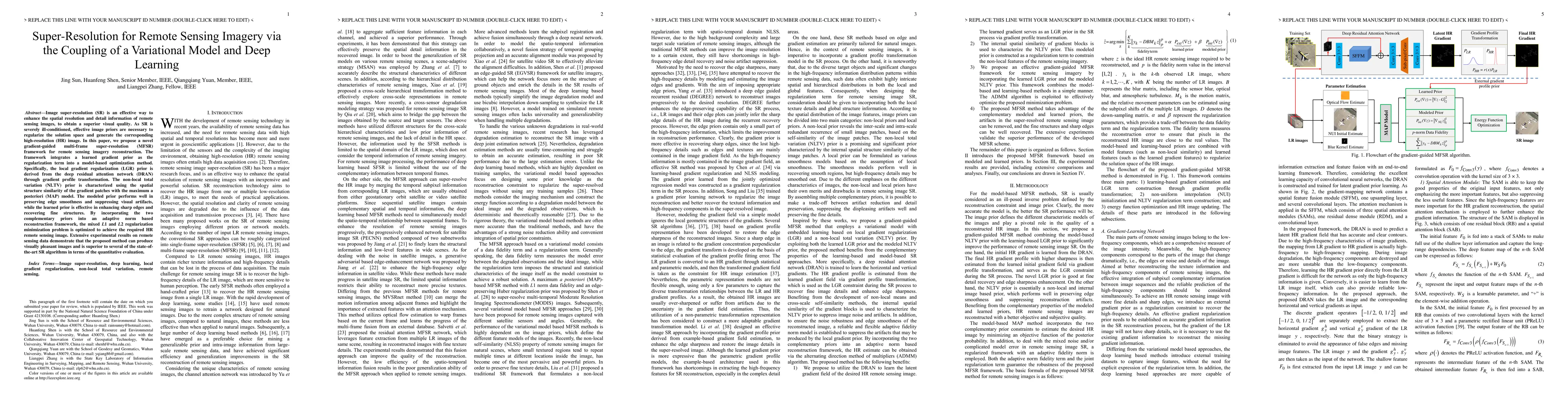
Image super-resolution (SR) is an effective way to enhance the spatial resolution and detail information of remote sensing images, to obtain a superior visual quality. As SR is severely ill-conditione...
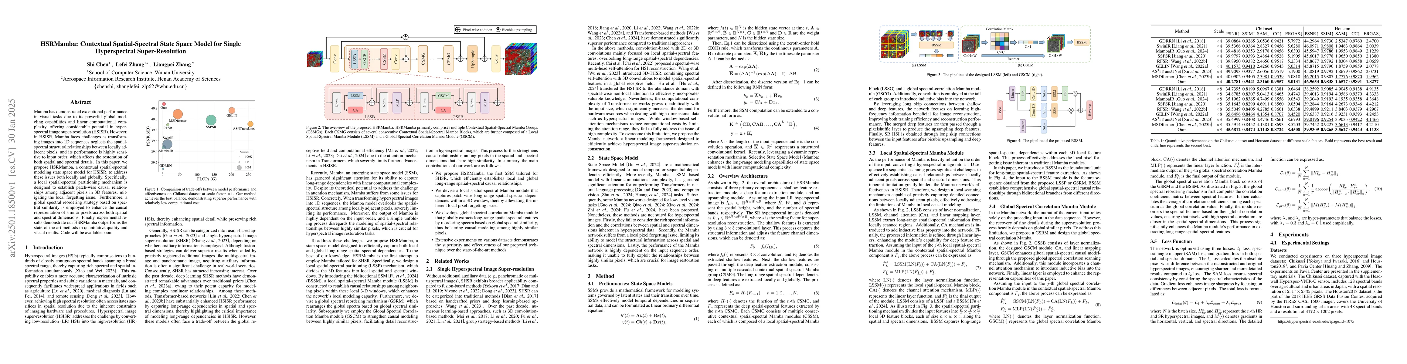
Mamba has demonstrated exceptional performance in visual tasks due to its powerful global modeling capabilities and linear computational complexity, offering considerable potential in hyperspectral im...
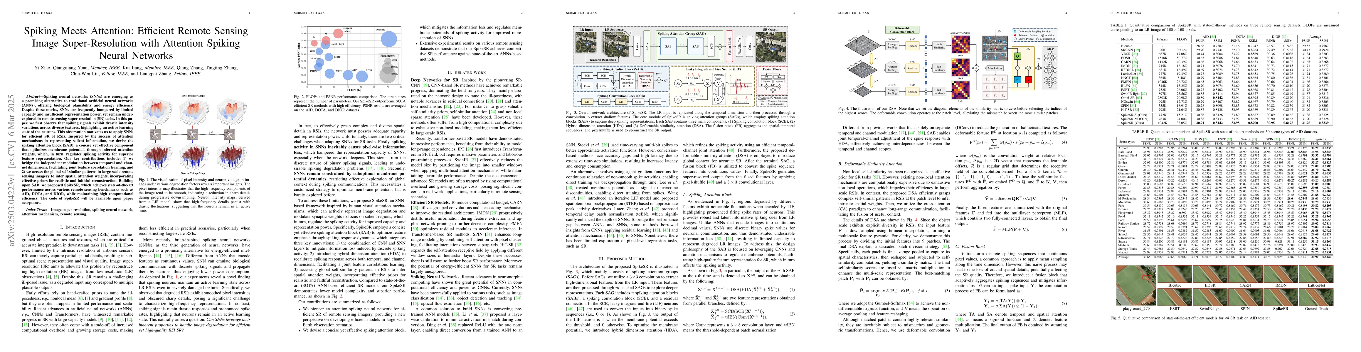
Spiking neural networks (SNNs) are emerging as a promising alternative to traditional artificial neural networks (ANNs), offering biological plausibility and energy efficiency. Despite these merits, S...
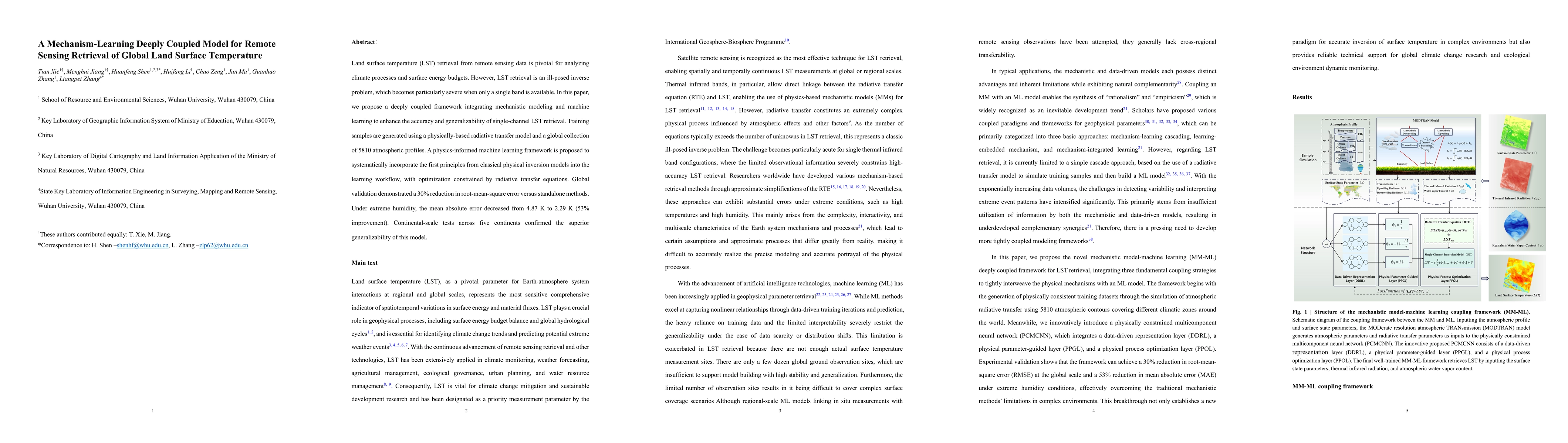
Land surface temperature (LST) retrieval from remote sensing data is pivotal for analyzing climate processes and surface energy budgets. However, LST retrieval is an ill-posed inverse problem, which b...

Large language models (LLMs) demonstrate strong performance across natural language processing tasks, yet undergo significant performance degradation when modified for deployment through quantization,...
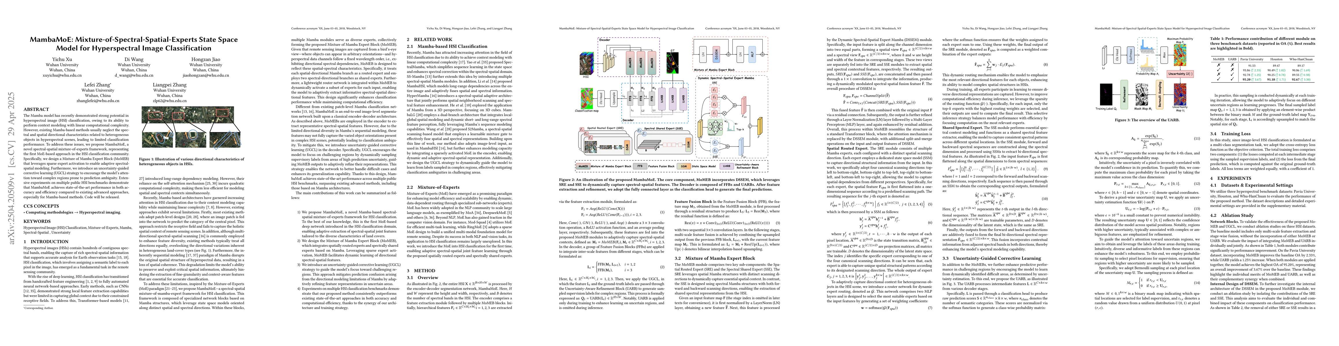
The Mamba model has recently demonstrated strong potential in hyperspectral image (HSI) classification, owing to its ability to perform context modeling with linear computational complexity. However, ...
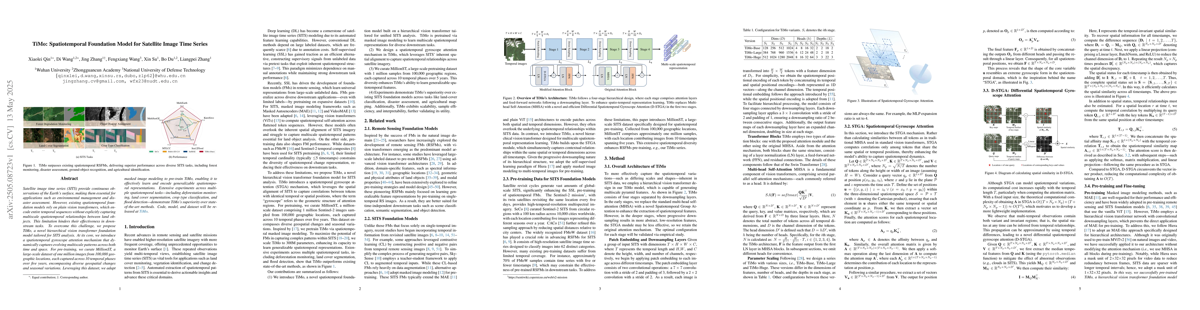
Satellite image time series (SITS) provide continuous observations of the Earth's surface, making them essential for applications such as environmental management and disaster assessment. However, exi...
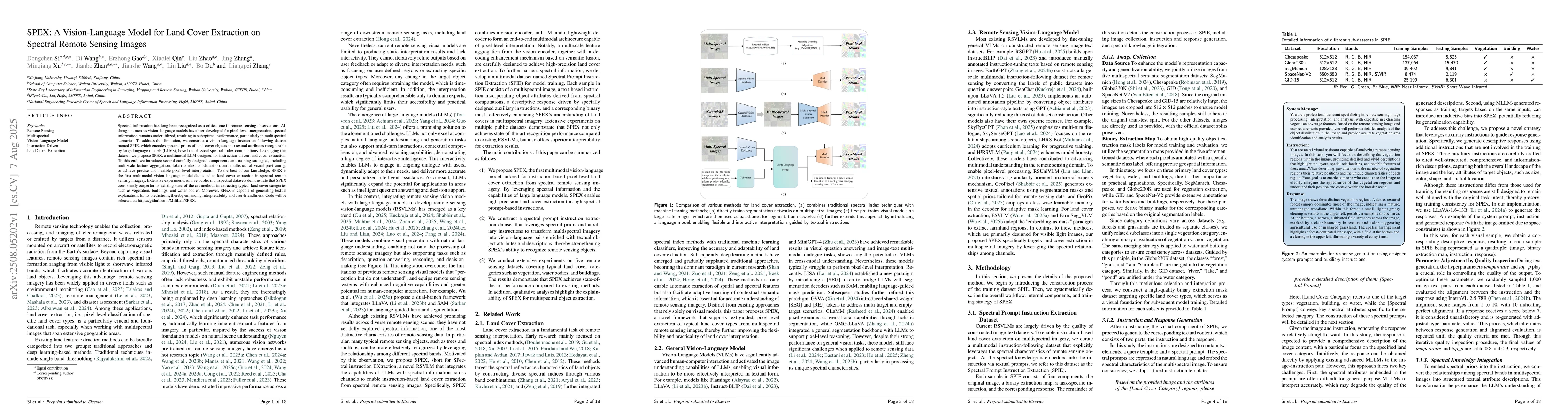
Spectral information has long been recognized as a critical cue in remote sensing observations. Although numerous vision-language models have been developed for pixel-level interpretation, spectral in...
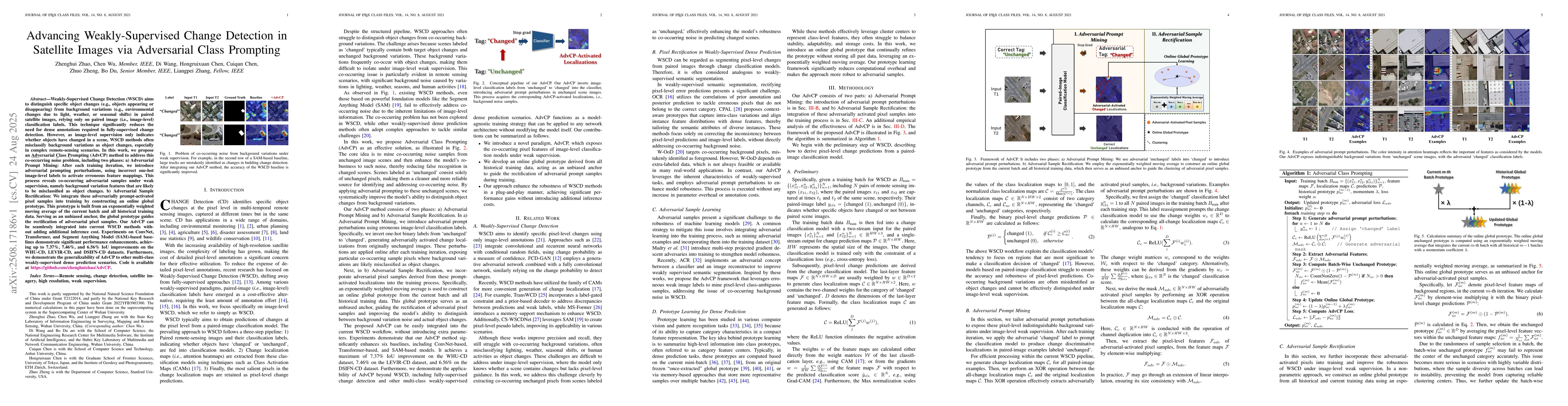
Weakly-Supervised Change Detection (WSCD) aims to distinguish specific object changes (e.g., objects appearing or disappearing) from background variations (e.g., environmental changes due to light, we...
Multimodal large language models (MLLMs) have undergone rapid development in advancing geospatial scene understanding. Recent studies have sought to enhance the reasoning capabilities of remote sensin...
Earth vision has achieved milestones in geospatial object recognition but lacks exploration in object-relational reasoning, limiting comprehensive scene understanding. To address this, a progressive E...
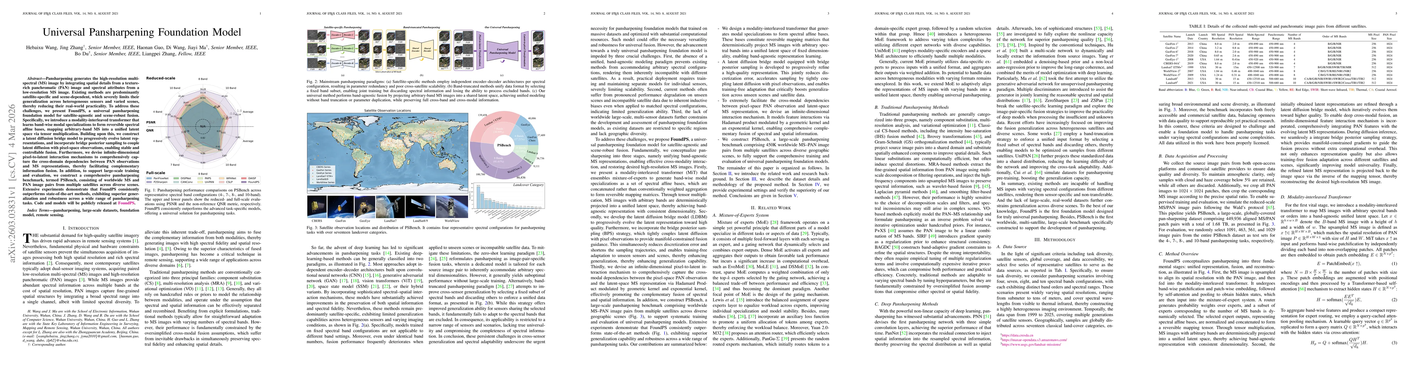
Pansharpening generates the high-resolution multi-spectral (MS) image by integrating spatial details from a texture-rich panchromatic (PAN) image and spectral attributes from a low-resolution MS image...