Remote Sensing ChatGPT: Solving Remote Sensing Tasks with ChatGPT and Visual Models
Publication
Metrics
AI Quick Summary
**Summary:** This paper introduces Remote Sensing ChatGPT, an advanced language model-powered agent that leverages the capabilities of large language models like ChatGPT to automate and interpret remote sensing tasks. By integrating visual cues, it enables non-expert users to request and receive detailed remote sensing interpretations directly from remote sensing images. **Link:** For more details and the code, visit the GitHub repository: https://github.com/HaonanGuo/Remote-Sensing-ChatGPT.
Paper Preview
Abstract
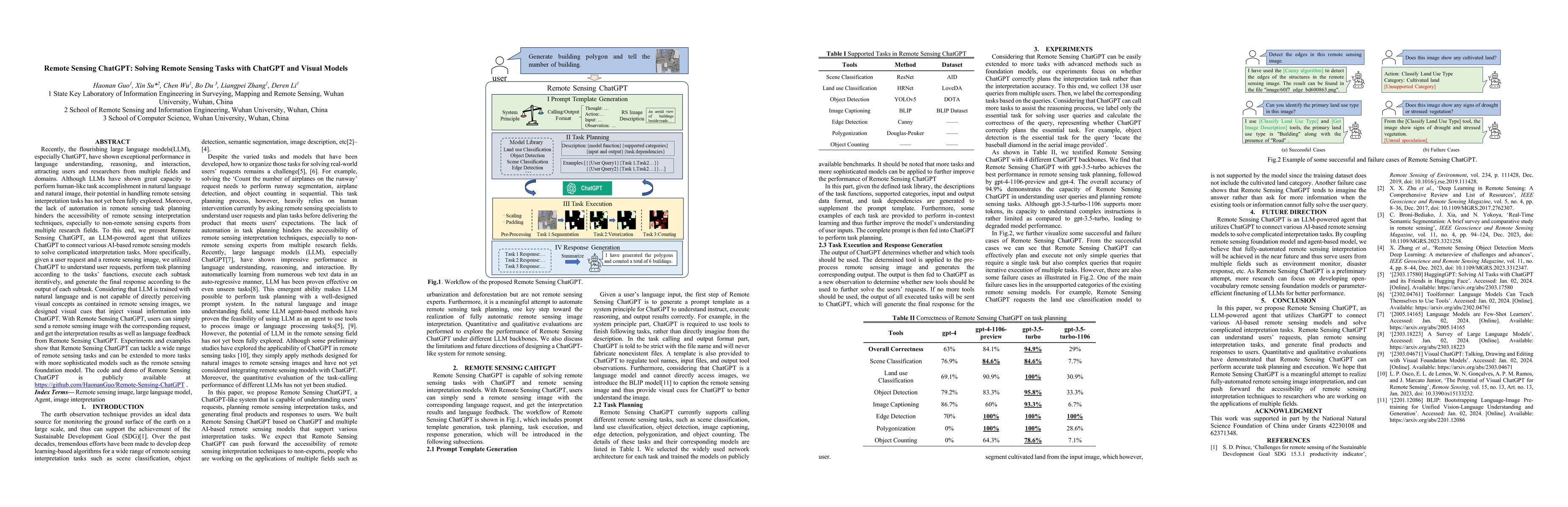
Recently, the flourishing large language models(LLM), especially ChatGPT, have shown exceptional performance in language understanding, reasoning, and interaction, attracting users and researchers from multiple fields and domains. Although LLMs have shown great capacity to perform human-like task accomplishment in natural language and natural image, their potential in handling remote sensing interpretation tasks has not yet been fully explored. Moreover, the lack of automation in remote sensing task planning hinders the accessibility of remote sensing interpretation techniques, especially to non-remote sensing experts from multiple research fields. To this end, we present Remote Sensing ChatGPT, an LLM-powered agent that utilizes ChatGPT to connect various AI-based remote sensing models to solve complicated interpretation tasks. More specifically, given a user request and a remote sensing image, we utilized ChatGPT to understand user requests, perform task planning according to the tasks' functions, execute each subtask iteratively, and generate the final response according to the output of each subtask. Considering that LLM is trained with natural language and is not capable of directly perceiving visual concepts as contained in remote sensing images, we designed visual cues that inject visual information into ChatGPT. With Remote Sensing ChatGPT, users can simply send a remote sensing image with the corresponding request, and get the interpretation results as well as language feedback from Remote Sensing ChatGPT. Experiments and examples show that Remote Sensing ChatGPT can tackle a wide range of remote sensing tasks and can be extended to more tasks with more sophisticated models such as the remote sensing foundation model. The code and demo of Remote Sensing ChatGPT is publicly available at https://github.com/HaonanGuo/Remote-Sensing-ChatGPT .
AI Key Findings
Get AI-generated insights about this paper's methodology, results, significance, and more — seven facets brought into focus.
Impact
Paper Details
Authors
PDF Preview
Key Terms
Citation Network
Current paper (gray), citations (green), references (blue)
Display is limited for performance on very large graphs.
Discussion 0