Academic Profile
Statistics
Similar Authors
Papers on arXiv
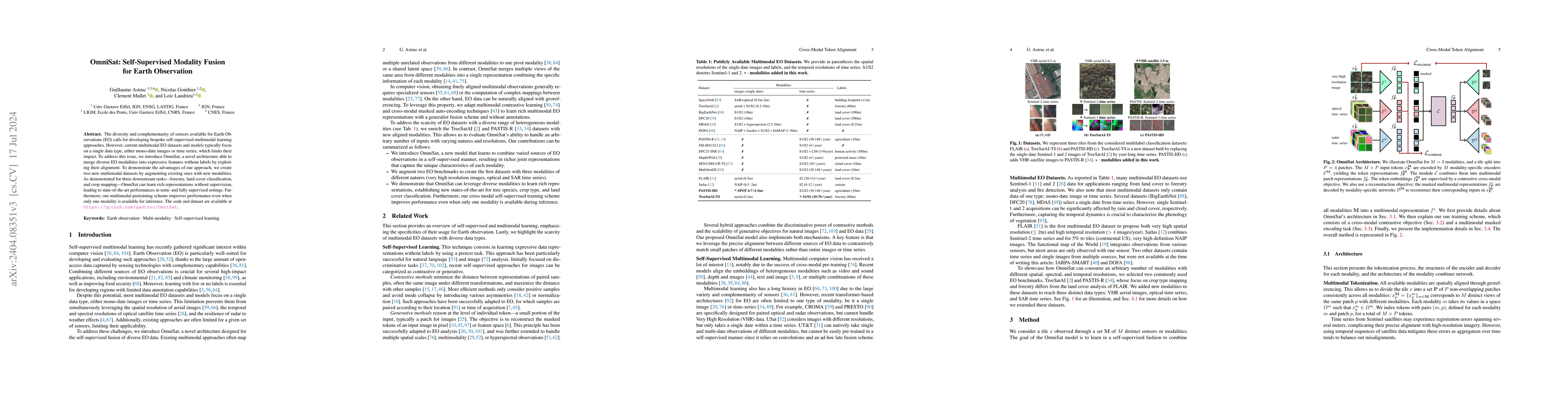
The field of Earth Observations (EO) offers a wealth of data from diverse sensors, presenting a great opportunity for advancing self-supervised multimodal learning. However, current multimodal EO data...
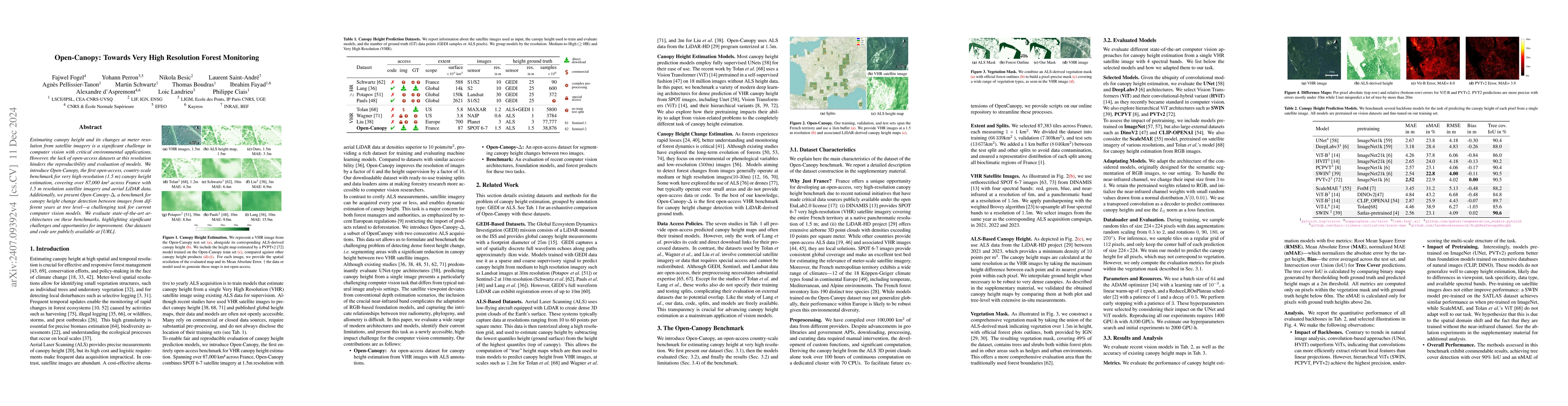
Estimating canopy height and canopy height change at meter resolution from satellite imagery has numerous applications, such as monitoring forest health, logging activities, wood resources, and carbon...
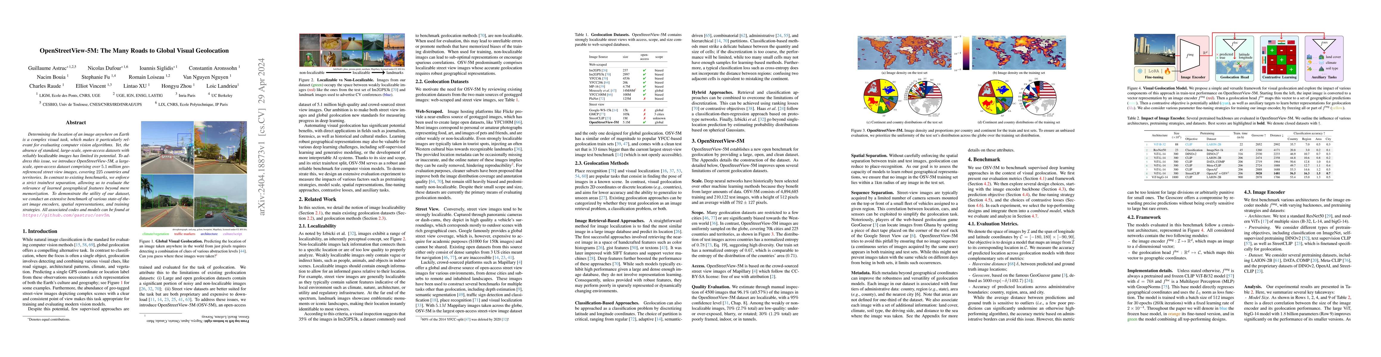
Determining the location of an image anywhere on Earth is a complex visual task, which makes it particularly relevant for evaluating computer vision algorithms. Yet, the absence of standard, large-s...
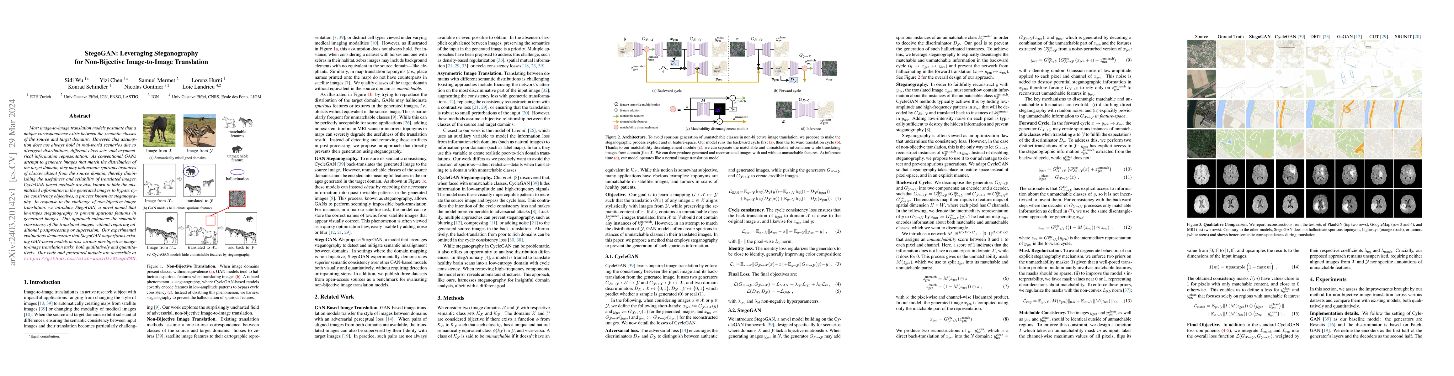
Most image-to-image translation models postulate that a unique correspondence exists between the semantic classes of the source and target domains. However, this assumption does not always hold in r...
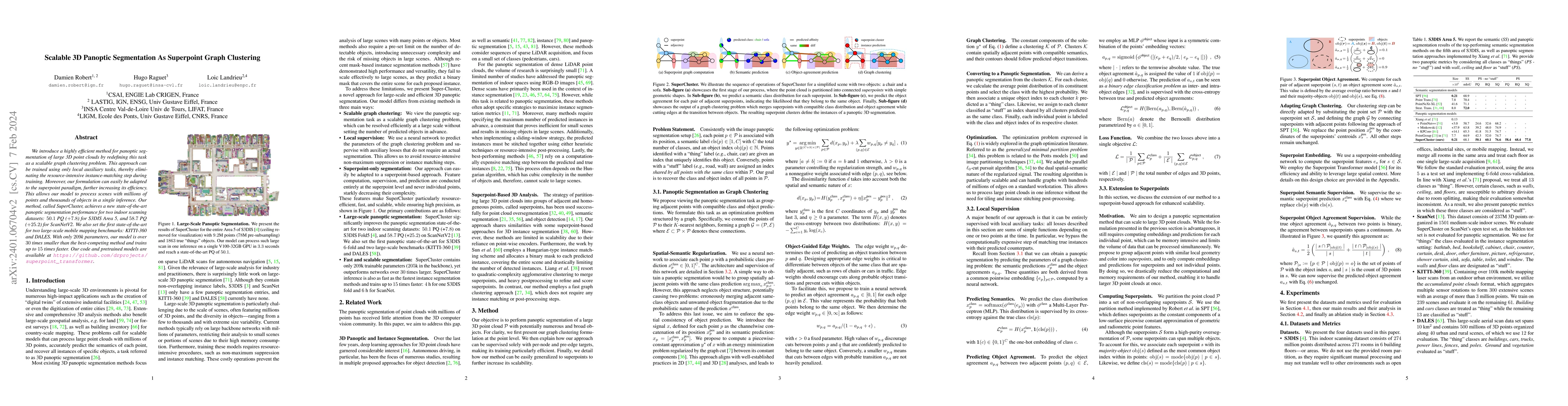
We introduce a highly efficient method for panoptic segmentation of large 3D point clouds by redefining this task as a scalable graph clustering problem. This approach can be trained using only loca...
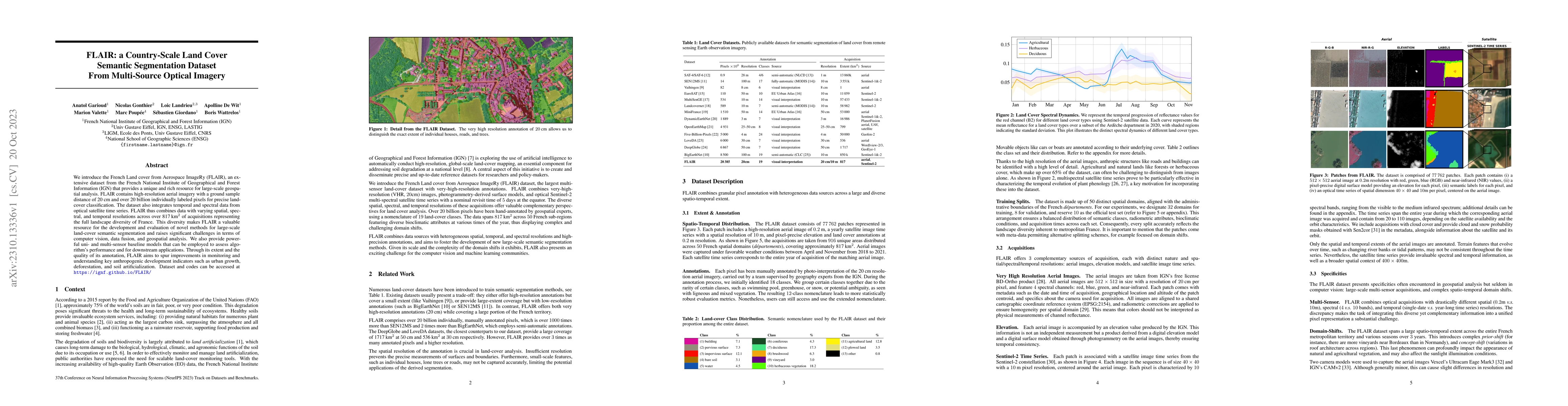
We introduce the French Land cover from Aerospace ImageRy (FLAIR), an extensive dataset from the French National Institute of Geographical and Forest Information (IGN) that provides a unique and ric...
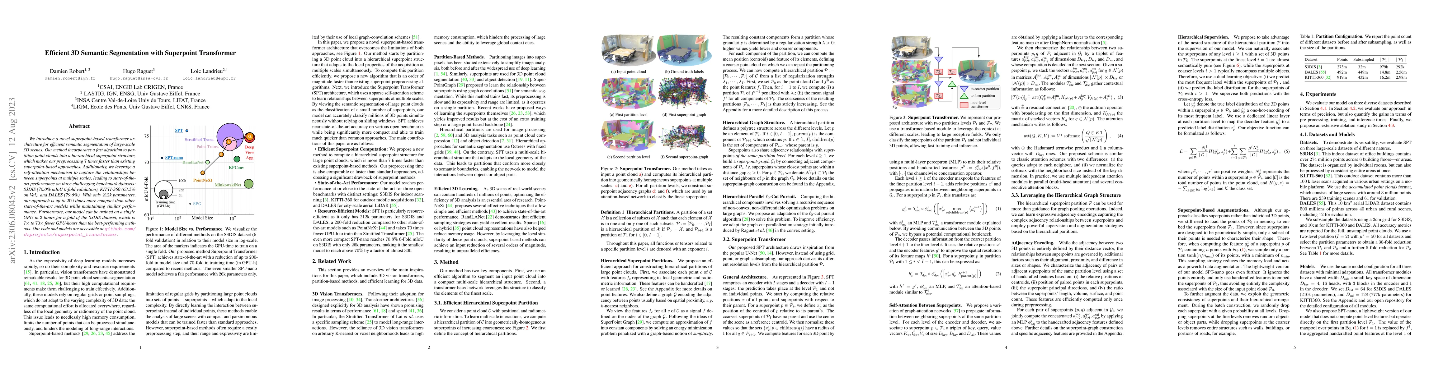
We introduce a novel superpoint-based transformer architecture for efficient semantic segmentation of large-scale 3D scenes. Our method incorporates a fast algorithm to partition point clouds into a...
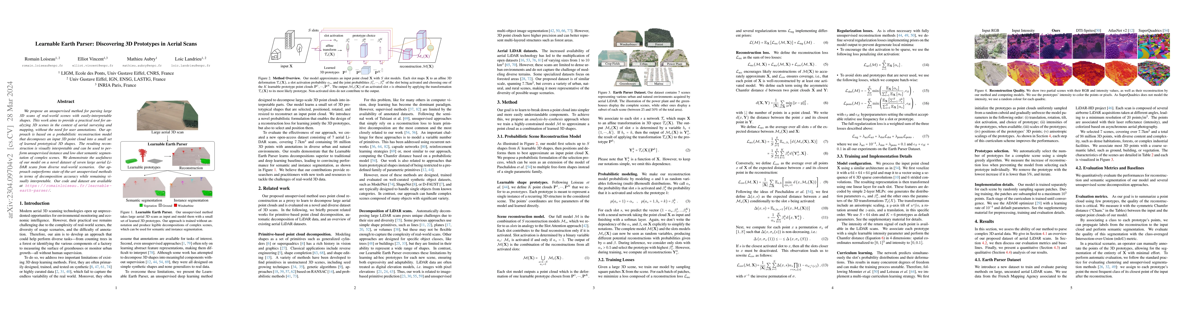
We propose an unsupervised method for parsing large 3D scans of real-world scenes with easily-interpretable shapes. This work aims to provide a practical tool for analyzing 3D scenes in the context ...
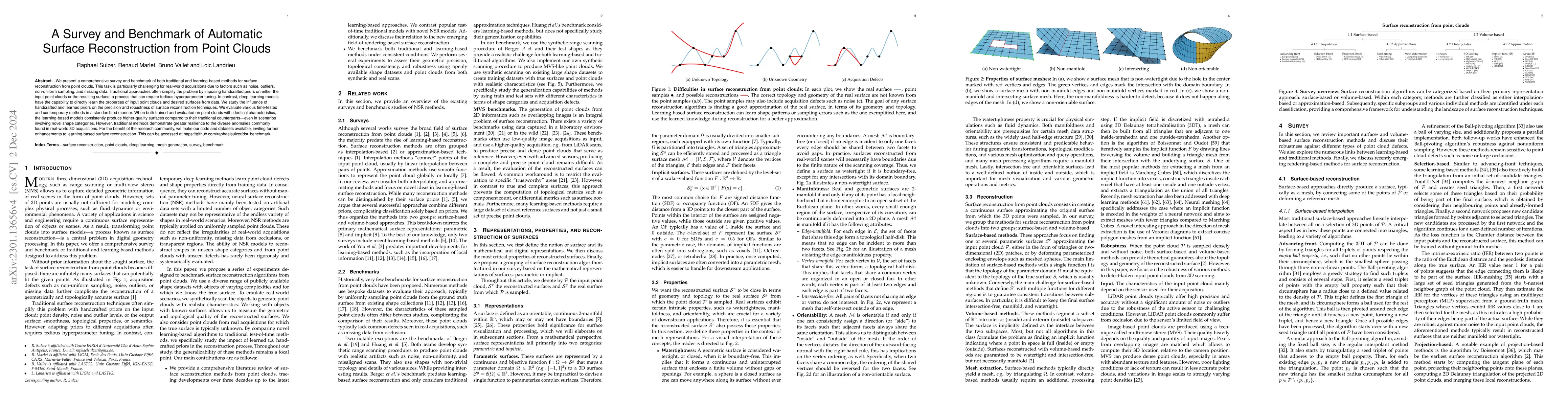
We present a comprehensive survey and benchmark of both traditional and learning-based methods for surface reconstruction from point clouds. This task is particularly challenging for real-world acqu...
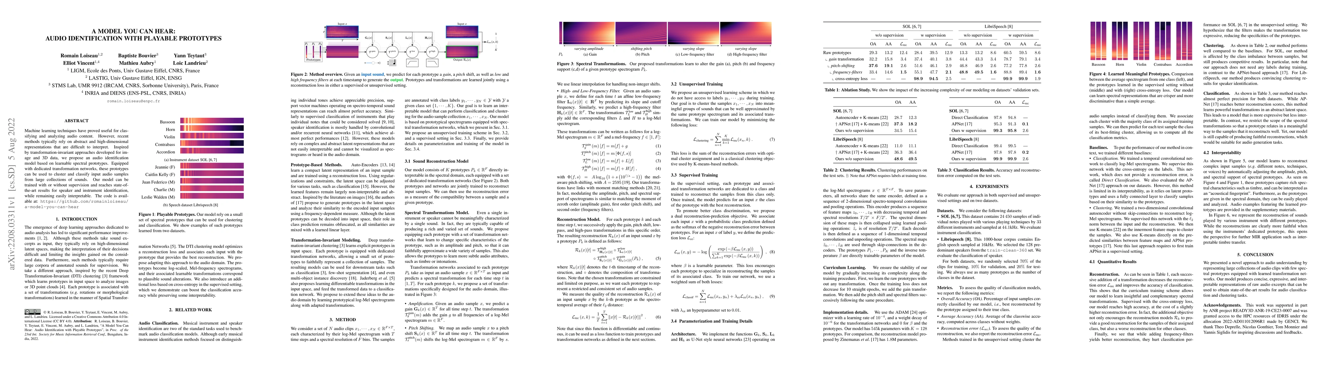
Machine learning techniques have proved useful for classifying and analyzing audio content. However, recent methods typically rely on abstract and high-dimensional representations that are difficult...
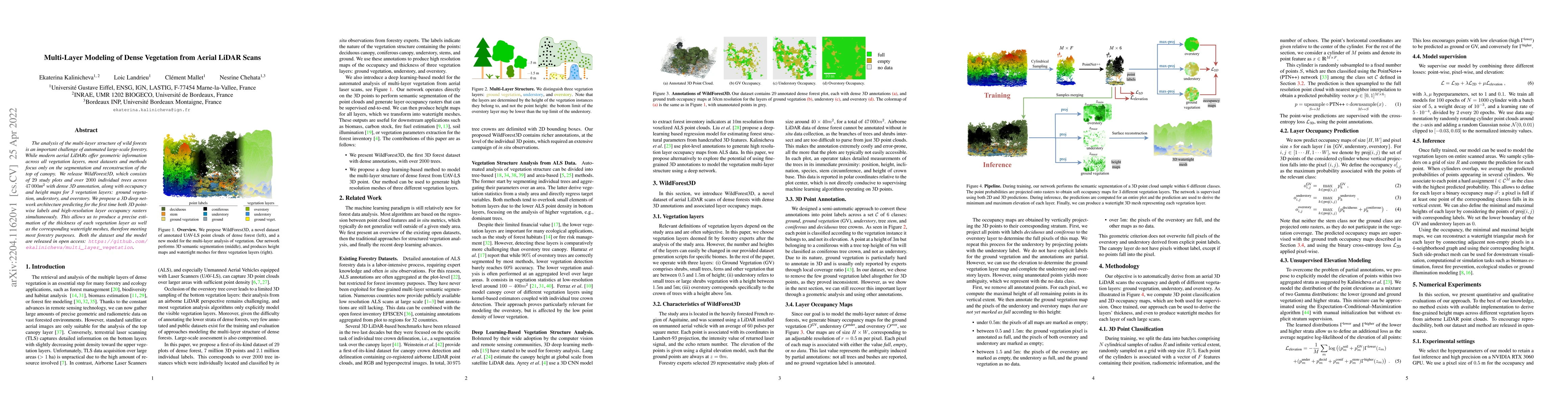
The analysis of the multi-layer structure of wild forests is an important challenge of automated large-scale forestry. While modern aerial LiDARs offer geometric information across all vegetation la...
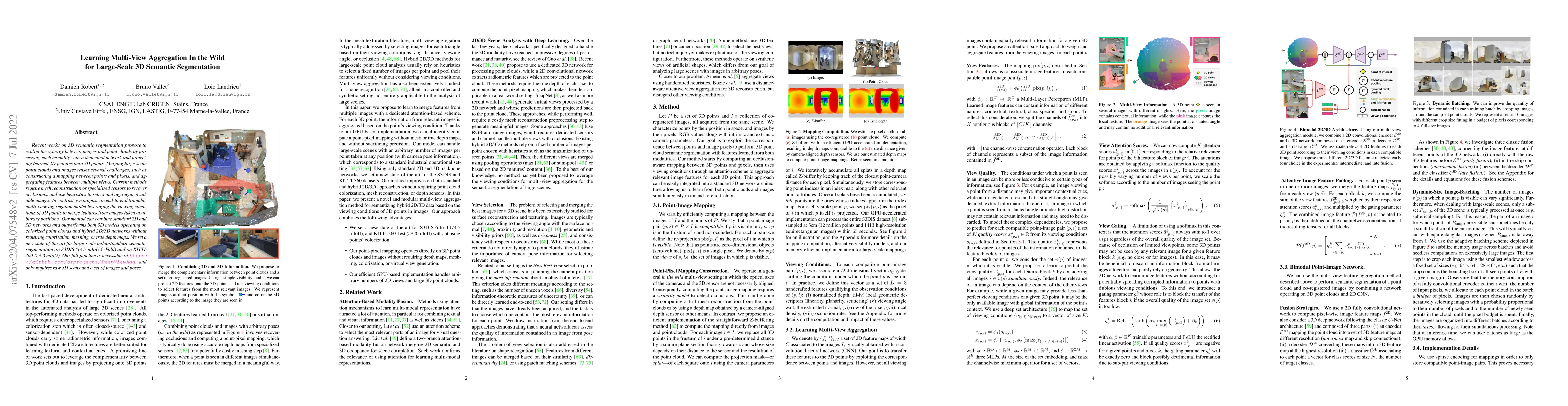
Recent works on 3D semantic segmentation propose to exploit the synergy between images and point clouds by processing each modality with a dedicated network and projecting learned 2D features onto 3...
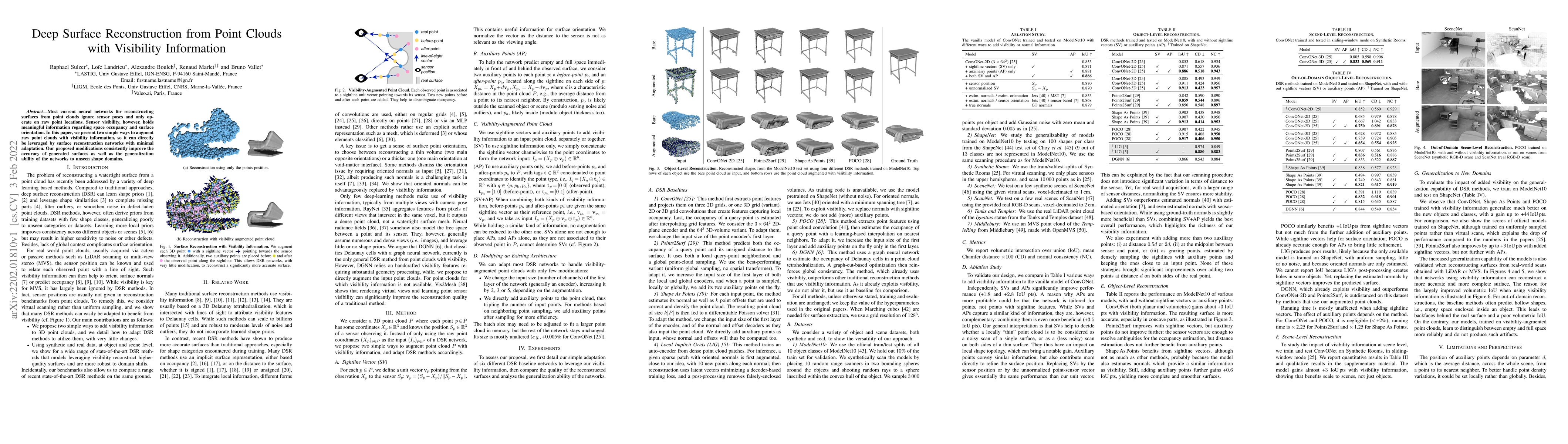
Most current neural networks for reconstructing surfaces from point clouds ignore sensor poses and only operate on raw point locations. Sensor visibility, however, holds meaningful information regar...
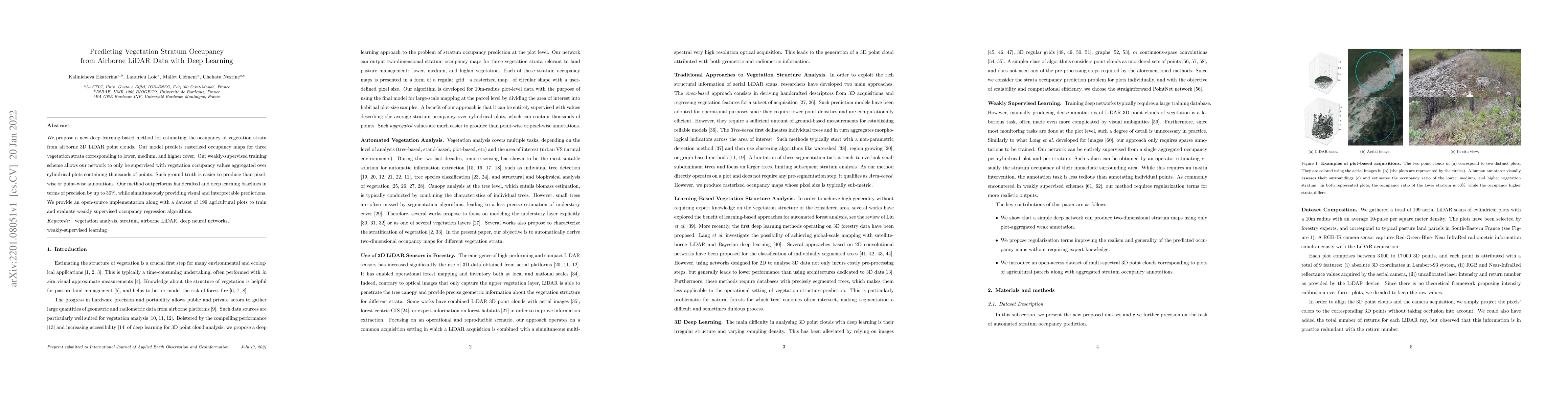
We propose a new deep learning-based method for estimating the occupancy of vegetation strata from airborne 3D LiDAR point clouds. Our model predicts rasterized occupancy maps for three vegetation s...
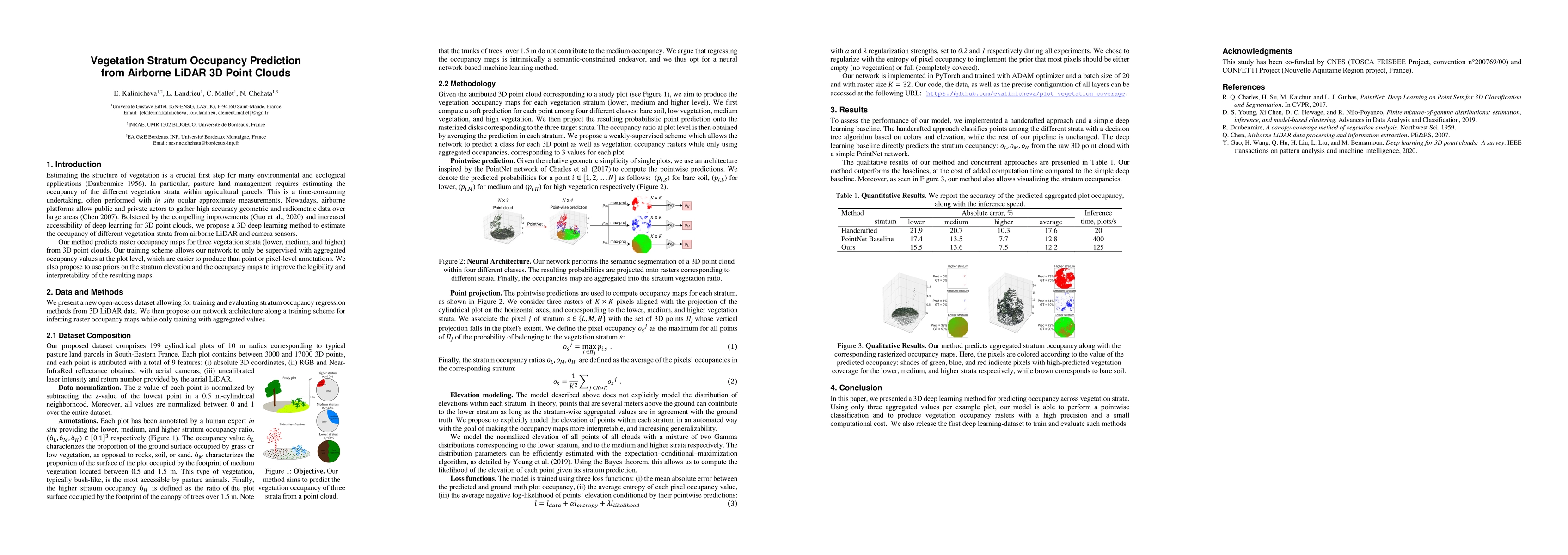
We propose a new deep learning-based method for estimating the occupancy of vegetation strata from 3D point clouds captured from an aerial platform. Our model predicts rasterized occupancy maps for ...
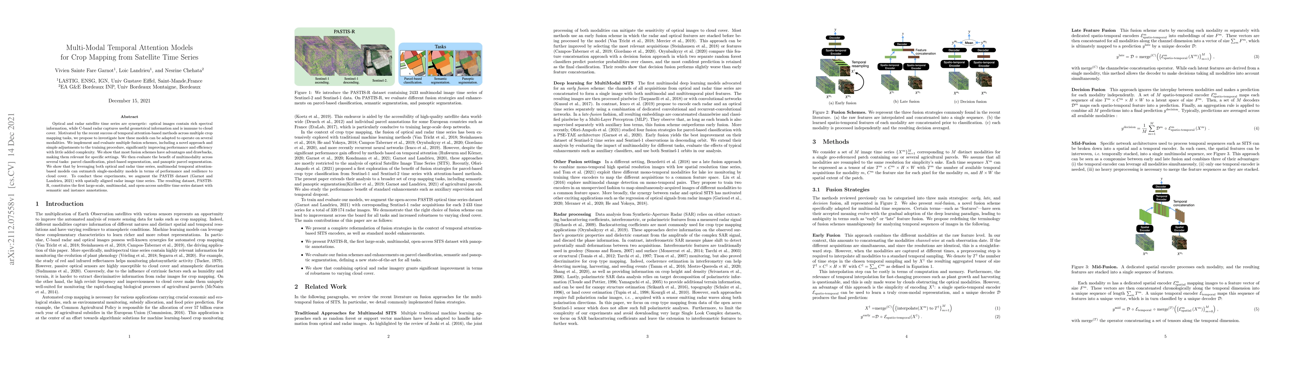
Optical and radar satellite time series are synergetic: optical images contain rich spectral information, while C-band radar captures useful geometrical information and is immune to cloud cover. Mot...
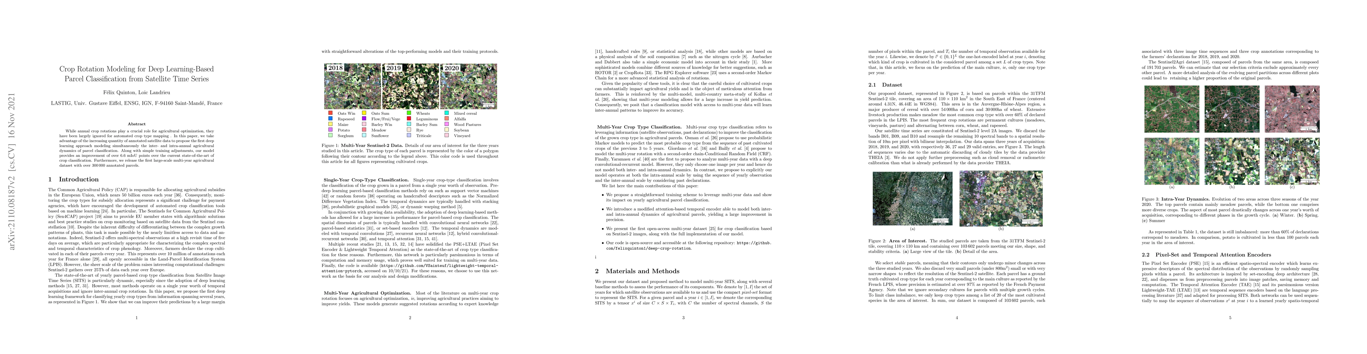
While annual crop rotations play a crucial role for agricultural optimization, they have been largely ignored for automated crop type mapping. In this paper, we take advantage of the increasing quan...
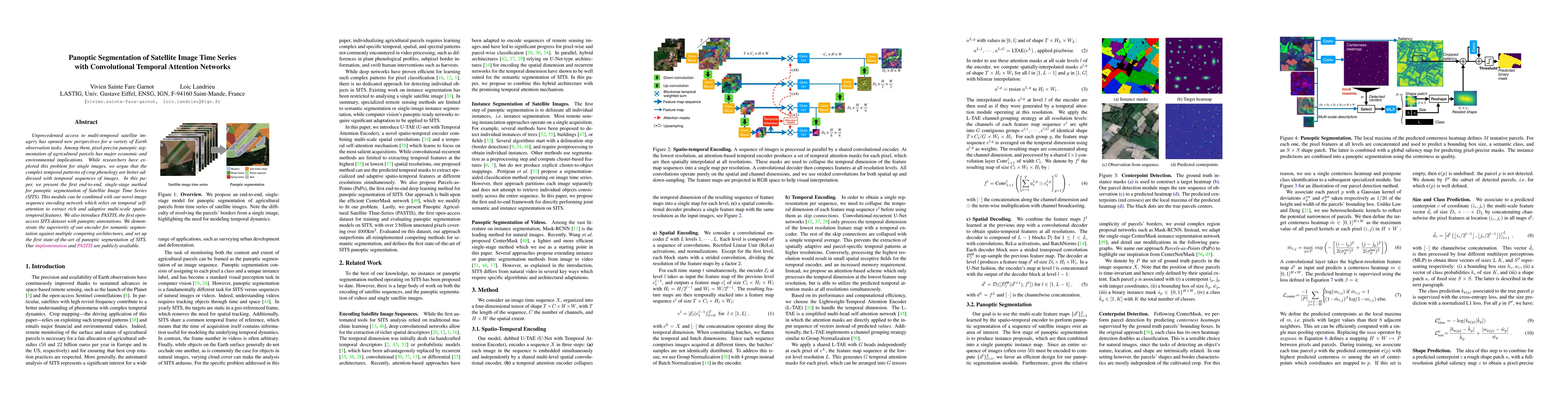
Unprecedented access to multi-temporal satellite imagery has opened new perspectives for a variety of Earth observation tasks. Among them, pixel-precise panoptic segmentation of agricultural parcels...
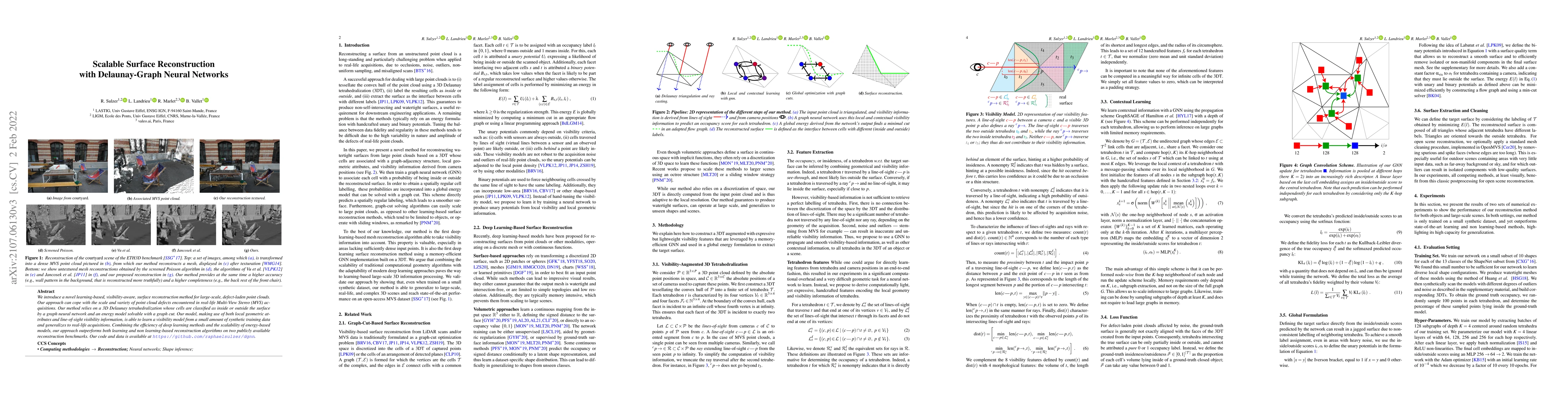
We introduce a novel learning-based, visibility-aware, surface reconstruction method for large-scale, defect-laden point clouds. Our approach can cope with the scale and variety of point cloud defec...
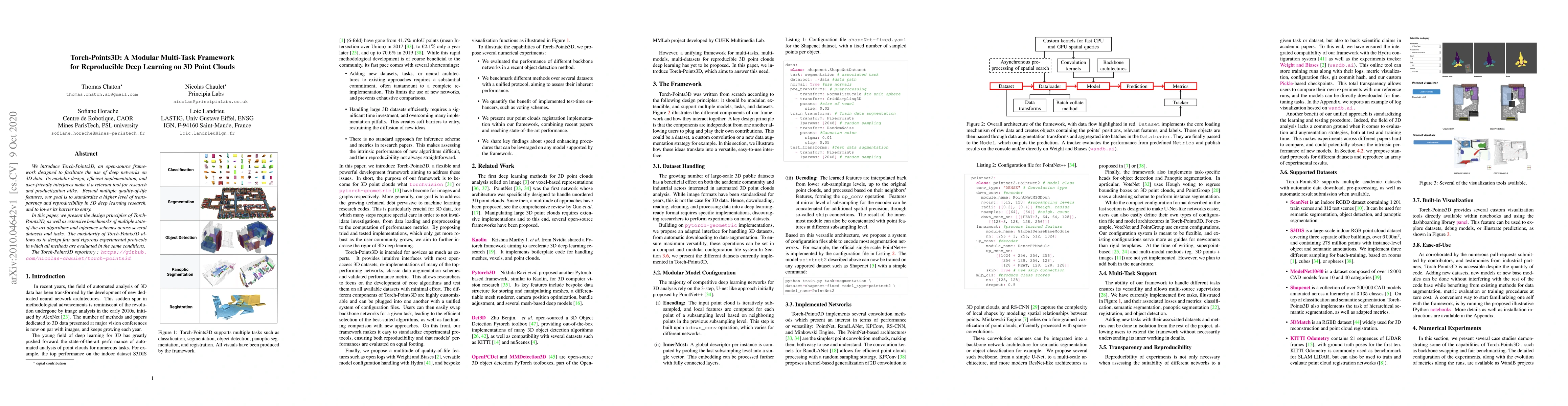
We introduce Torch-Points3D, an open-source framework designed to facilitate the use of deep networks on3D data. Its modular design, efficient implementation, and user-friendly interfaces make it a ...
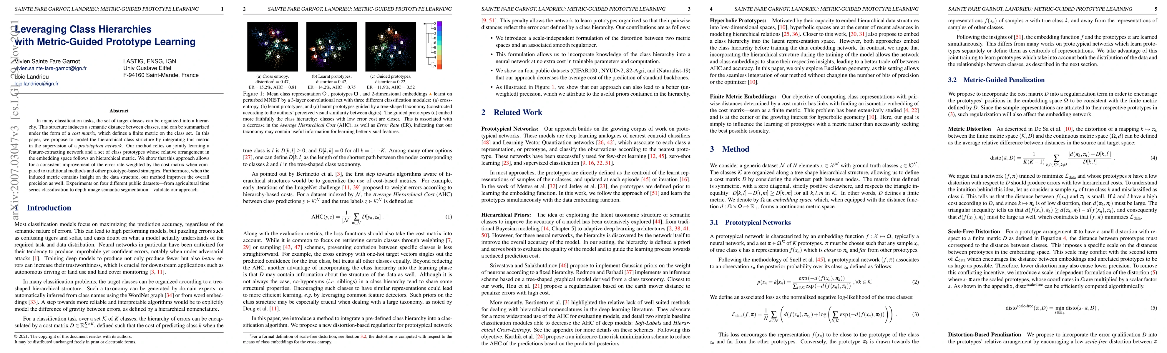
In many classification tasks, the set of target classes can be organized into a hierarchy. This structure induces a semantic distance between classes, and can be summarised under the form of a cost ...
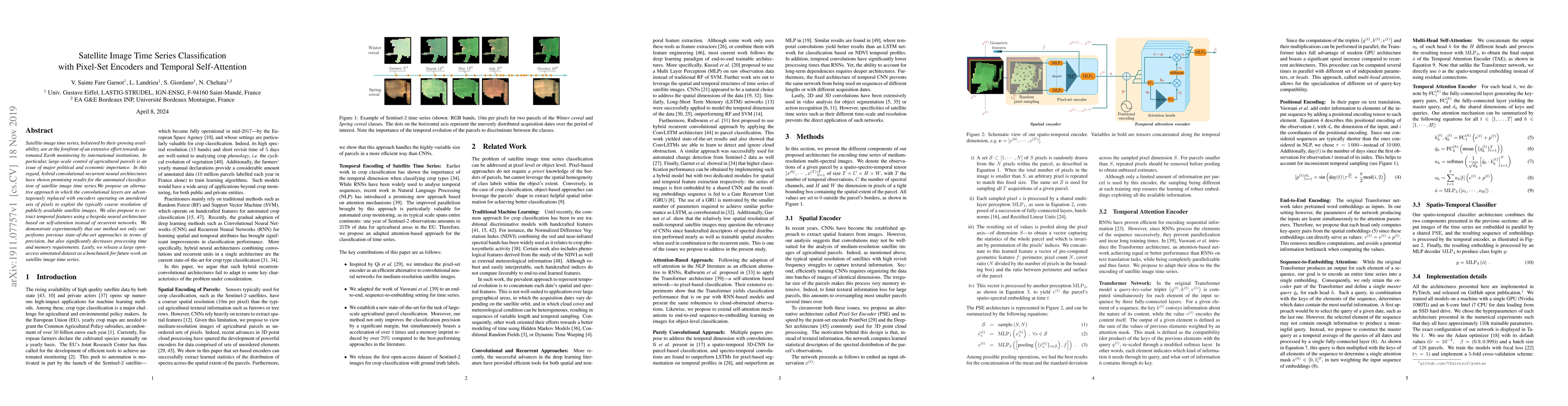
Satellite image time series, bolstered by their growing availability, are at the forefront of an extensive effort towards automated Earth monitoring by international institutions. In particular, lar...
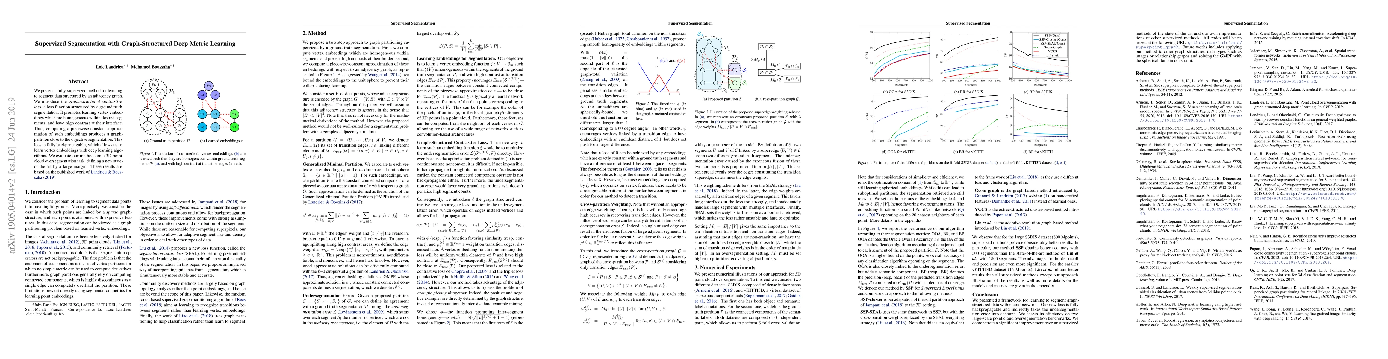
We present a fully-supervized method for learning to segment data structured by an adjacency graph. We introduce the graph-structured contrastive loss, a loss function structured by a ground truth s...
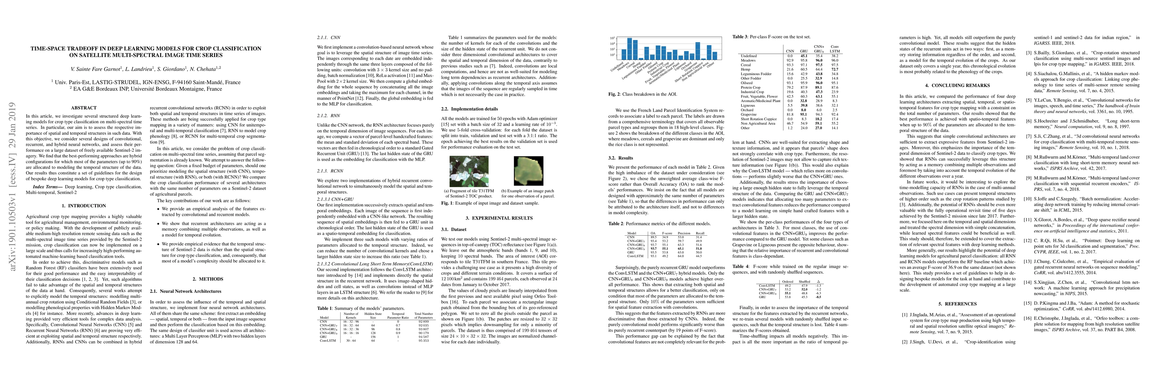
In this article, we investigate several structured deep learning models for crop type classification on multi-spectral time series. In particular, our aim is to assess the respective importance of s...
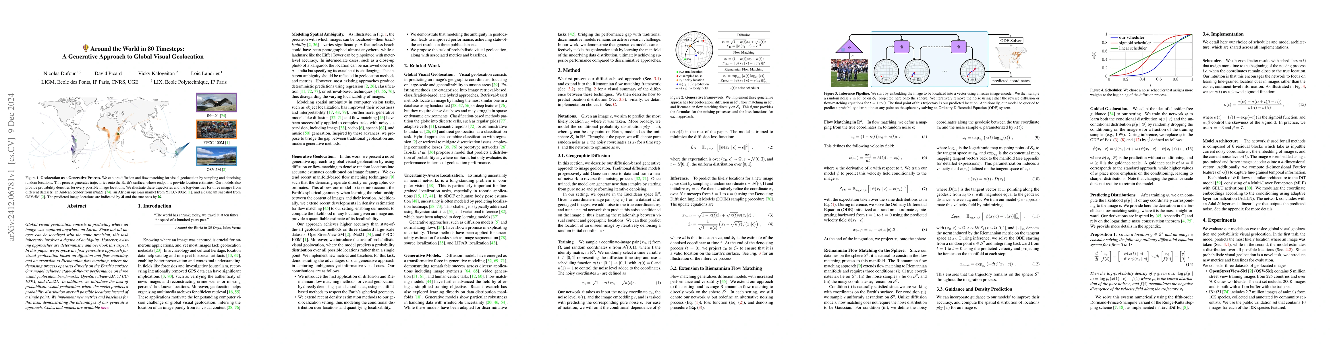
Global visual geolocation predicts where an image was captured on Earth. Since images vary in how precisely they can be localized, this task inherently involves a significant degree of ambiguity. Howe...
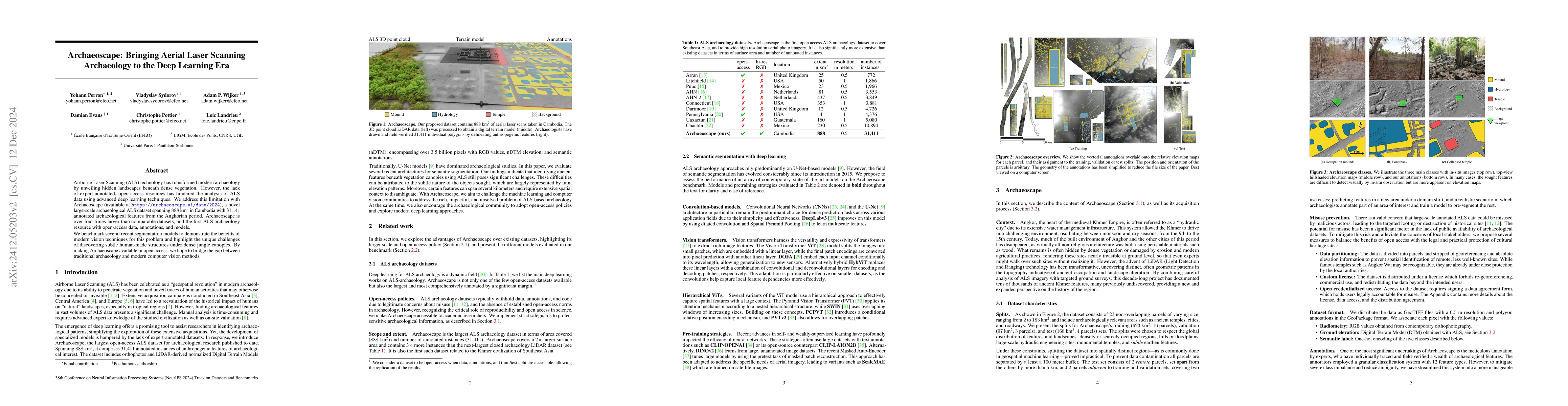
Airborne Laser Scanning (ALS) technology has transformed modern archaeology by unveiling hidden landscapes beneath dense vegetation. However, the lack of expert-annotated, open-access resources has hi...
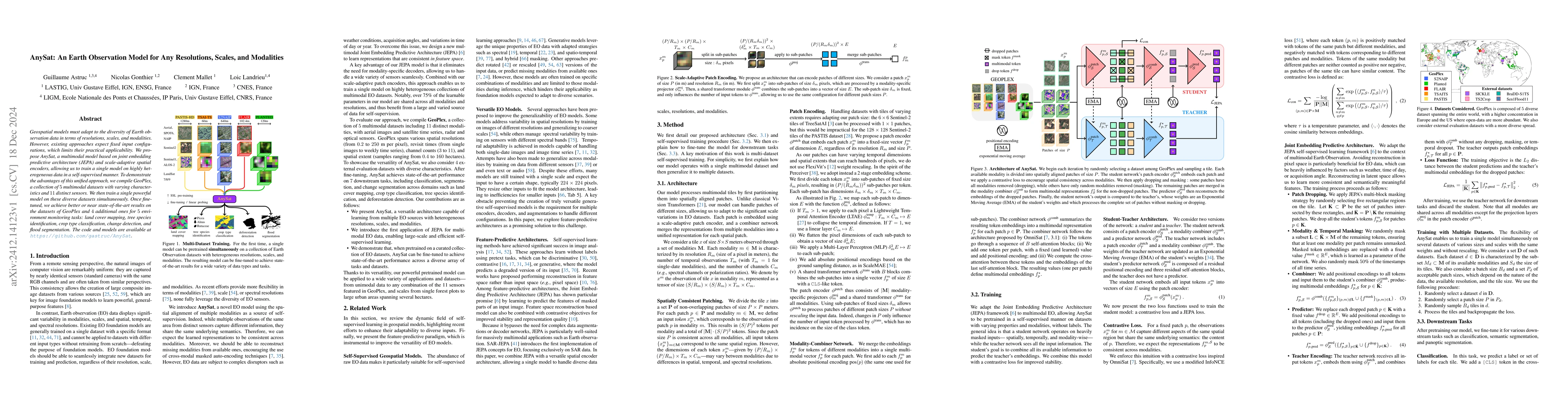
Geospatial models must adapt to the diversity of Earth observation data in terms of resolutions, scales, and modalities. However, existing approaches expect fixed input configurations, which limits th...

Global variations in terrain appearance raise a major challenge for satellite image analysis, leading to poor model performance when training on locations that differ from those encountered at test ti...
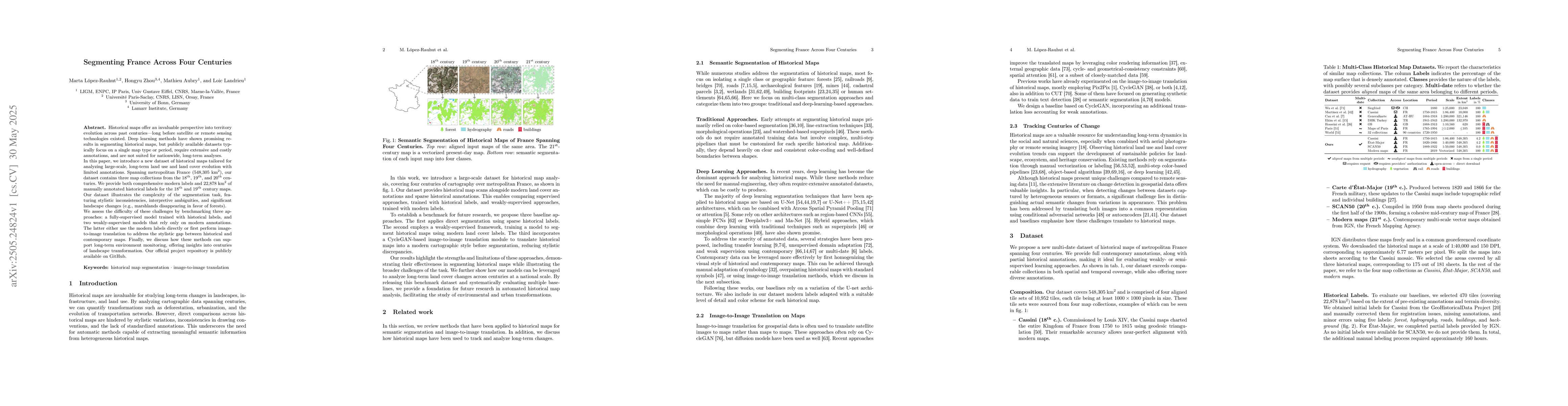
Historical maps offer an invaluable perspective into territory evolution across past centuries--long before satellite or remote sensing technologies existed. Deep learning methods have shown promising...

Superpoint-based pipelines provide an efficient alternative to point- or voxel-based 3D semantic segmentation, but are often bottlenecked by their CPU-bound partition step. We propose a learnable, ful...
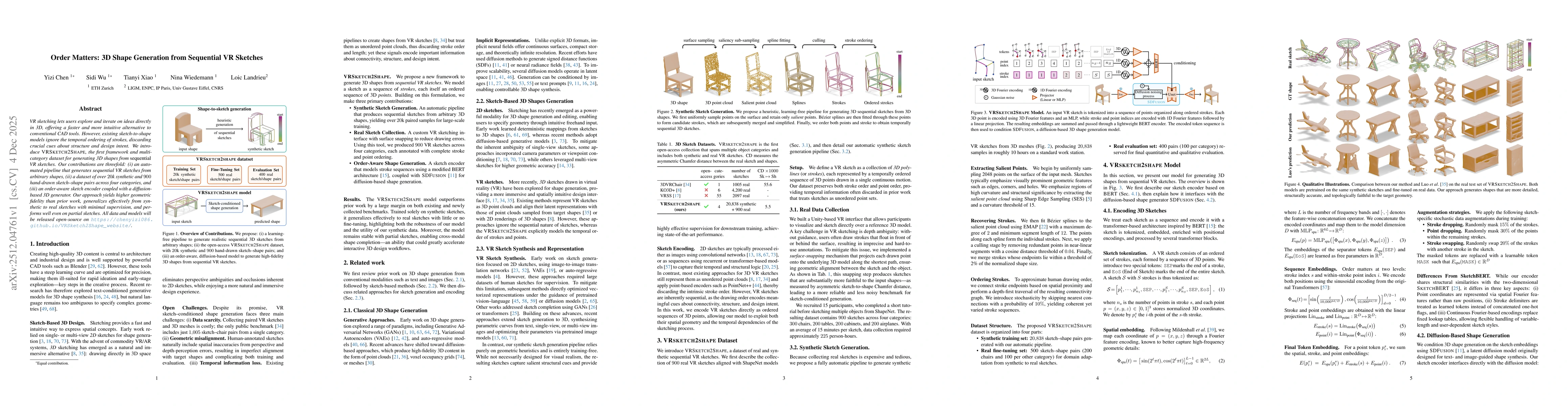
VR sketching lets users explore and iterate on ideas directly in 3D, offering a faster and more intuitive alternative to conventional CAD tools. However, existing sketch-to-shape models ignore the tem...
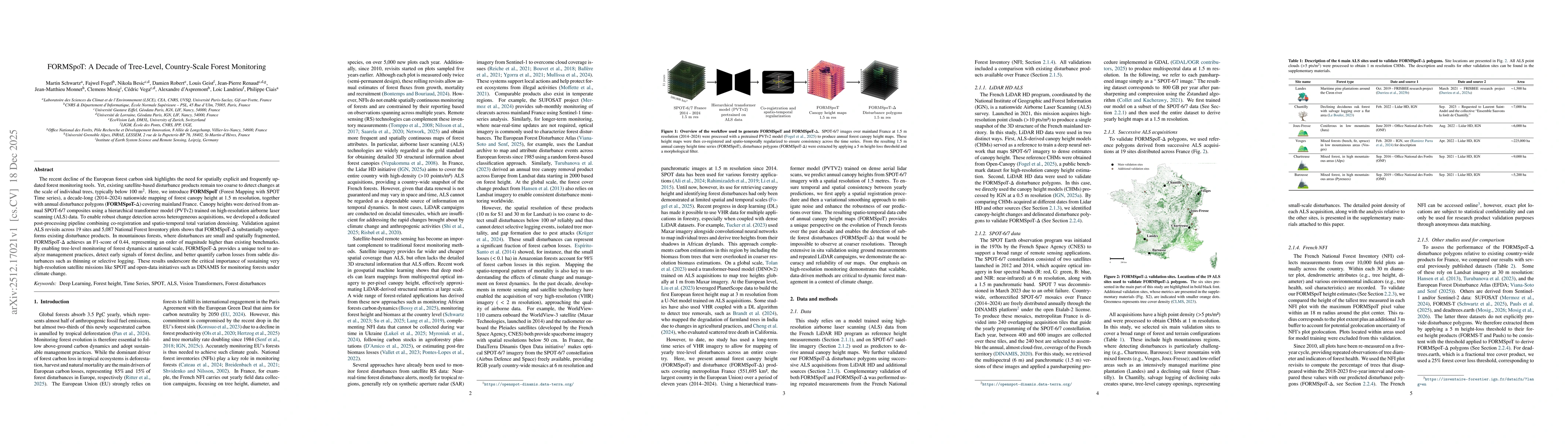
The recent decline of the European forest carbon sink highlights the need for spatially explicit and frequently updated forest monitoring tools. Yet, existing satellite-based disturbance products rema...
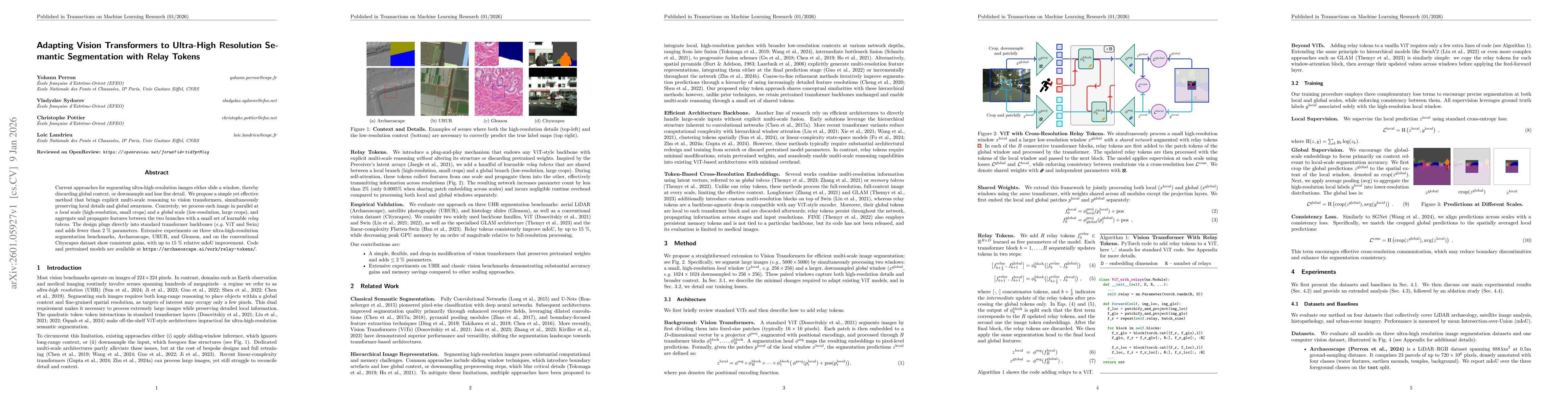
Current approaches for segmenting ultra high resolution images either slide a window, thereby discarding global context, or downsample and lose fine detail. We propose a simple yet effective method th...
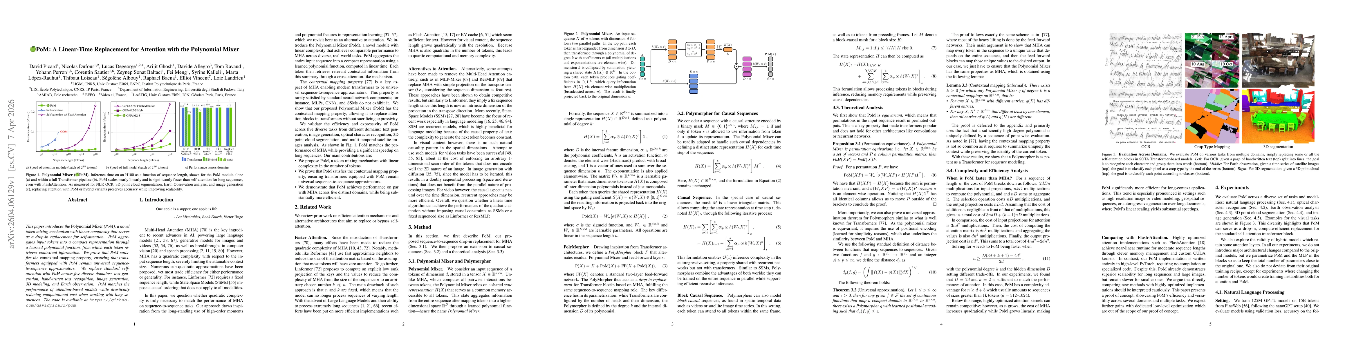
This paper introduces the Polynomial Mixer (PoM), a novel token mixing mechanism with linear complexity that serves as a drop-in replacement for self-attention. PoM aggregates input tokens into a comp...
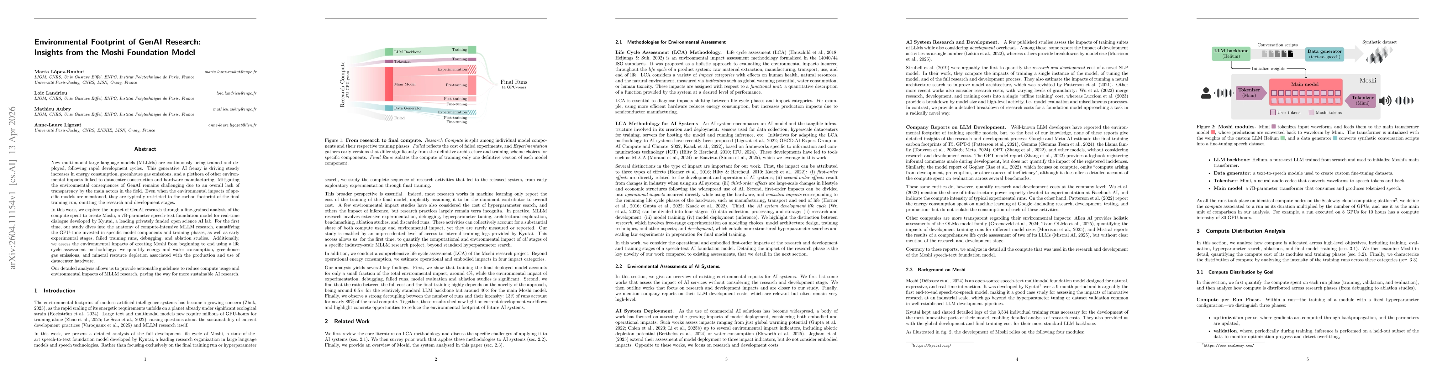
New multi-modal large language models (MLLMs) are continuously being trained and deployed, following rapid development cycles. This generative AI frenzy is driving steady increases in energy consumpti...
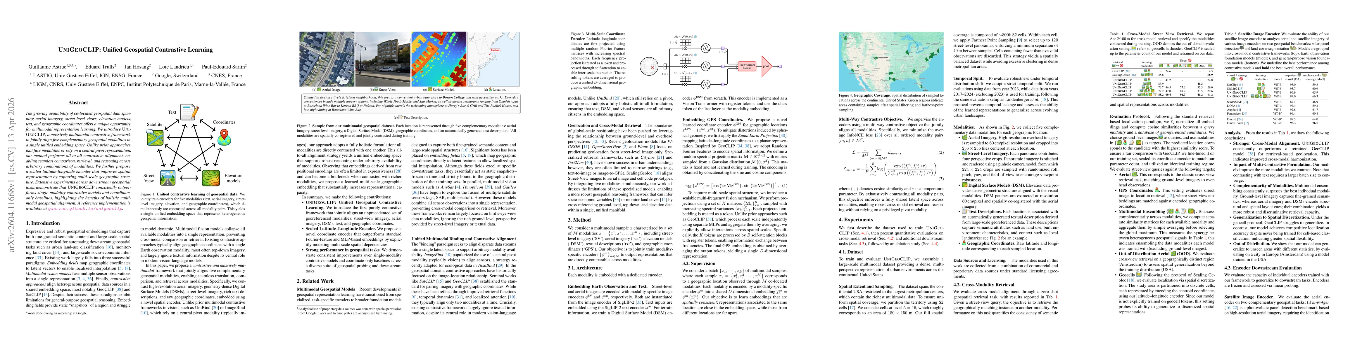
The growing availability of co-located geospatial data spanning aerial imagery, street-level views, elevation models, text, and geographic coordinates offers a unique opportunity for multimodal repres...

Vision Transformers (ViT) dominate computer vision. However, their reliance on rigid patch projectors hinders transfer to Earth Observation (EO), where input modalities, scales, and resolutions vary w...
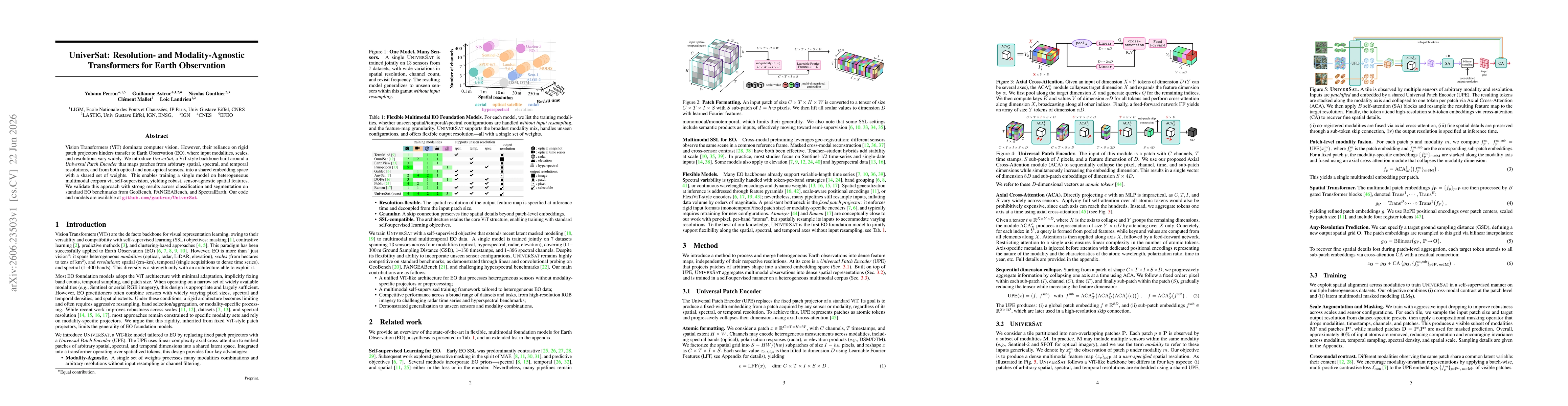
Vision Transformers (ViT) dominate computer vision. However, their reliance on rigid patch projectors hinders transfer to Earth Observation (EO), where input modalities, scales, and resolutions vary w...

Counting individual trees is a fundamental task for environmental monitoring, yet remains largely unexplored with satellite imagery. At these resolutions, isolated trees may still be identifiable, but...