This paper introduces a new dataset of historical maps for analyzing long-term land use and land cover evolution in France, providing a platform for large-scale, nationwide analyses with limited annotations.
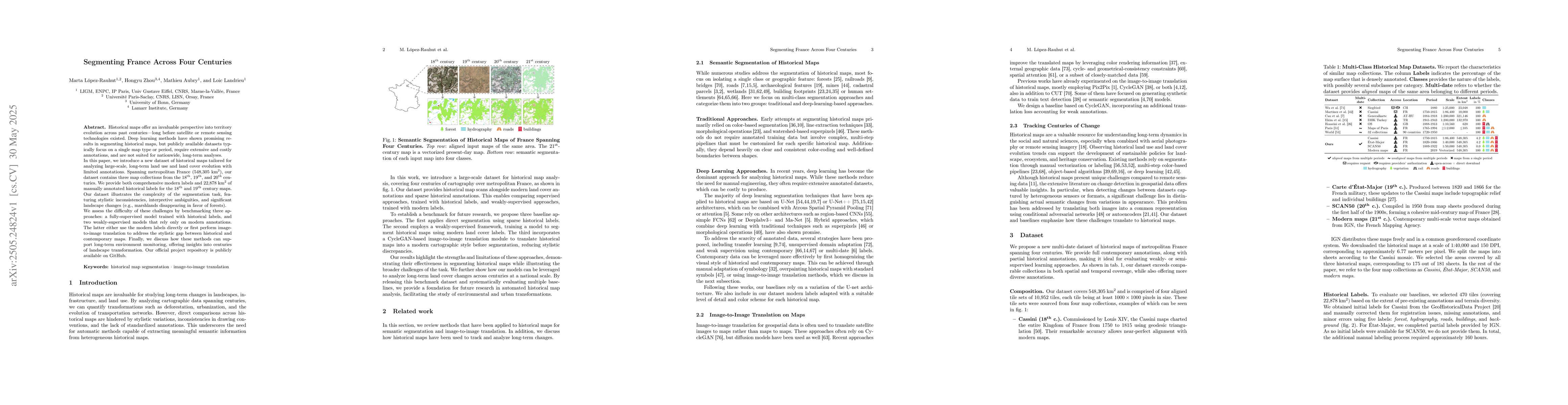
Historical maps offer an invaluable perspective into territory evolution across past centuries--long before satellite or remote sensing technologies existed. Deep learning methods have shown promising results in segmenting historical maps, but publicly available datasets typically focus on a single map type or period, require extensive and costly annotations, and are not suited for nationwide, long-term analyses. In this paper, we introduce a new dataset of historical maps tailored for analyzing large-scale, long-term land use and land cover evolution with limited annotations. Spanning metropolitan France (548,305 km^2), our dataset contains three map collections from the 18th, 19th, and 20th centuries. We provide both comprehensive modern labels and 22,878 km^2 of manually annotated historical labels for the 18th and 19th century maps. Our dataset illustrates the complexity of the segmentation task, featuring stylistic inconsistencies, interpretive ambiguities, and significant landscape changes (e.g., marshlands disappearing in favor of forests). We assess the difficulty of these challenges by benchmarking three approaches: a fully-supervised model trained with historical labels, and two weakly-supervised models that rely only on modern annotations. The latter either use the modern labels directly or first perform image-to-image translation to address the stylistic gap between historical and contemporary maps. Finally, we discuss how these methods can support long-term environment monitoring, offering insights into centuries of landscape transformation. Our official project repository is publicly available at https://github.com/Archiel19/FRAx4.git.
Generated Jun 09, 2025
The research introduces a dataset of historical maps from 18th, 19th, and 20th centuries in metropolitan France, providing both comprehensive modern labels and manually annotated historical labels for 18th and 19th-century maps. It benchmarks three approaches—a fully-supervised model, and two weakly-supervised models using modern annotations directly or via image-to-image translation—for segmenting historical maps.
This research is important as it introduces a dataset for historical map segmentation across four centuries, facilitating the evaluation of both fully- and weakly-supervised approaches. It highlights the potential of using modern labels to learn segmentation of unlabeled maps, enabling long-term monitoring of landscape features like forests across centuries.
The paper presents a novel dataset of historical maps with extensive contemporary annotations and partial historical labels, along with a translation+segmentation baseline that significantly enhances segmentation performance by translating historical maps into a modern style before applying a model trained on modern maps.
This work is novel as it combines extensive historical map annotations with modern labels to create a dataset suitable for evaluating both fully- and weakly-supervised approaches, thereby enabling long-term landscape monitoring using machine learning techniques.
Current paper (gray), citations (green), references (blue)
Display is limited for performance on very large graphs.
Sojung Lucia Kim, Taehong Jang, Joonmo Ahn et al.
F. Berrilli, S. Criscuoli, L. Bertello et al.
No citations found for this paper.
Comments (0)