ArxivLens
M
Researcher

M. Kiani

9 papers on arXiv

9 arXiv Papers
Profile

Academic Profile

Metrics

Statistics

9 arXiv Papers
Publications

Papers on arXiv

Thumbnail for Possibility of Land Movement Prediction for Creep or before Earthquake
  Using Lidar Geodetic Data in a Machine Learning Scheme
arXiv
Possibility of Land Movement Prediction for Creep or before Earthquake Using Lidar Geodetic Data in a Machine Learning Scheme

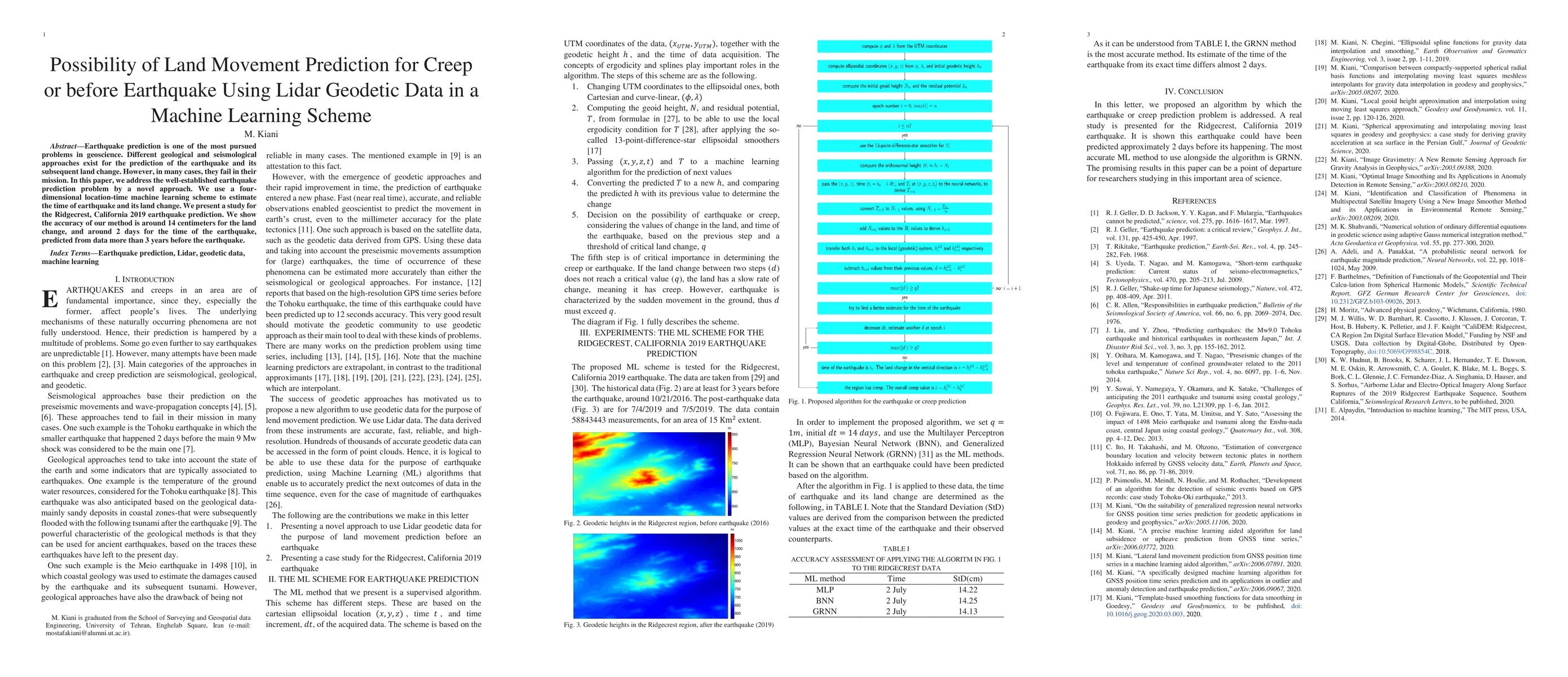
Earthquake prediction is one of the most pursued problems in geoscience. Different geological and seismological approaches exist for the prediction of the earthquake and its subsequent land change. ...

Thumbnail for A specifically designed machine learning algorithm for GNSS position
  time series prediction and its applications in outlier and anomaly detection
  and earthquake prediction
arXiv
A specifically designed machine learning algorithm for GNSS position time series prediction and its applications in outlier and anomaly detection and earthquake prediction

We present a simple yet efficient supervised machine learning algorithm that is designed for the GNSS position time series prediction. This algorithm has four steps. First, the mean value of the tim...

Thumbnail for Lateral land movement prediction from GNSS position time series in a
  machine learning aided algorithm
arXiv
Lateral land movement prediction from GNSS position time series in a machine learning aided algorithm

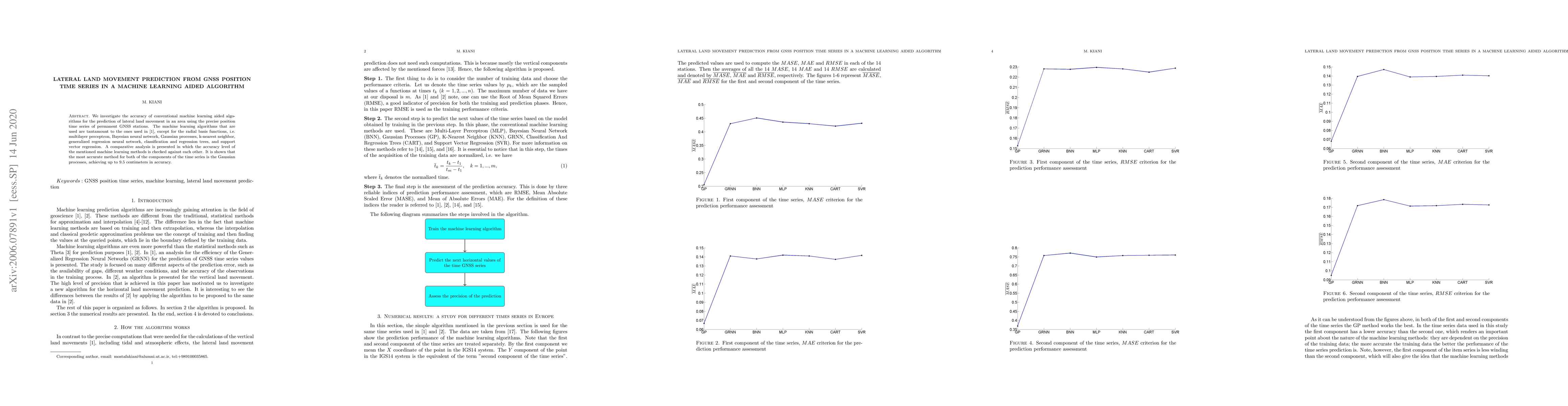
We investigate the accuracy of conventional machine learning aided algorithms for the prediction of lateral land movement in an area using the precise position time series of permanent GNSS stations...

Thumbnail for A precise machine learning aided algorithm for land subsidence or
  upheave prediction from GNSS time series
arXiv
A precise machine learning aided algorithm for land subsidence or upheave prediction from GNSS time series

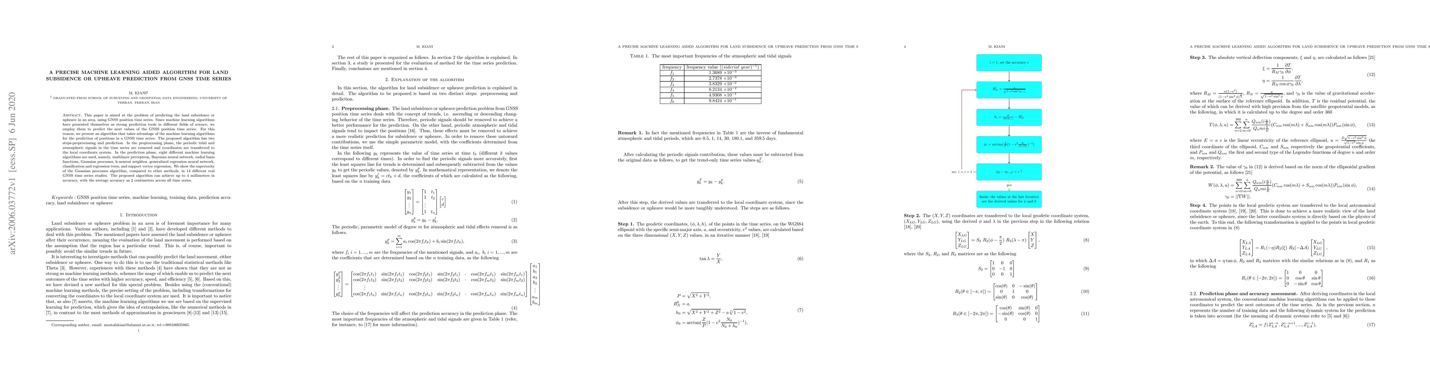
This paper is aimed at the problem of predicting the land subsidence or upheave in an area, using GNSS position time series. Since machine learning algorithms have presented themselves as strong pre...

Thumbnail for On the suitability of generalized regression neural networks for GNSS
  position time series prediction for geodetic applications in geodesy and
  geophysics
arXiv
On the suitability of generalized regression neural networks for GNSS position time series prediction for geodetic applications in geodesy and geophysics

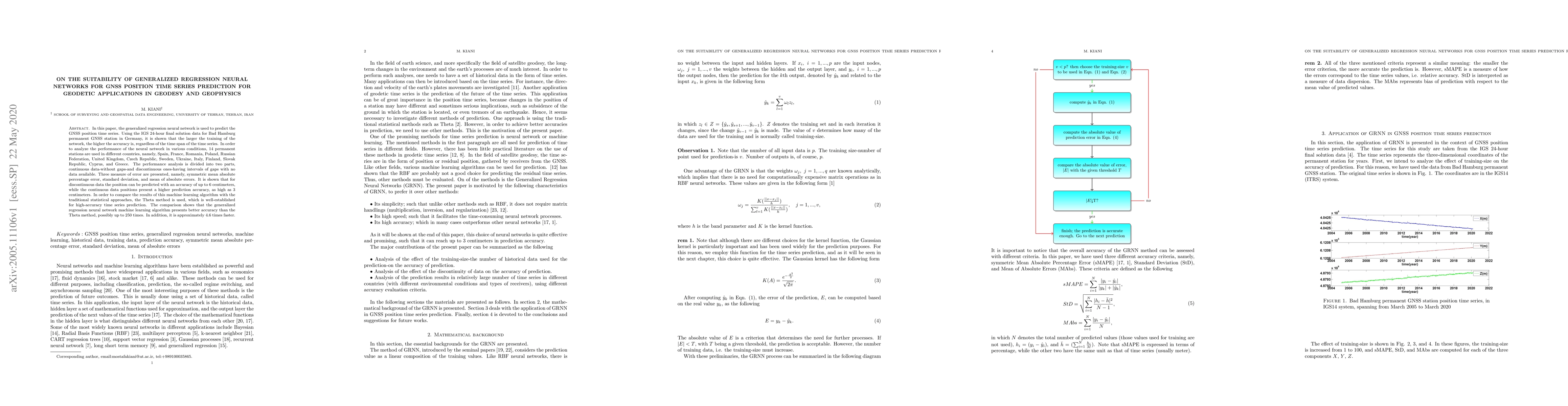
In this paper, the generalized regression neural network is used to predict the GNSS position time series. Using the IGS 24-hour final solution data for Bad Hamburg permanent GNSS station in Germany...

Thumbnail for Comparison between compactly-supported spherical radial basis functions
  and interpolating moving least squares meshless interpolants for gravity data
  interpolation in geodesy and geophysics
arXiv
Comparison between compactly-supported spherical radial basis functions and interpolating moving least squares meshless interpolants for gravity data interpolation in geodesy and geophysics

The present paper is focused on the comparison of the efficiency of two important meshless interpolants for gravity acceleration interpolation. Compactly-supported spherical radial basis functions a...

Thumbnail for Image Gravimetry: A New Remote Sensing Approach for Gravity Analysis in
  Geophysics
arXiv
Image Gravimetry: A New Remote Sensing Approach for Gravity Analysis in Geophysics

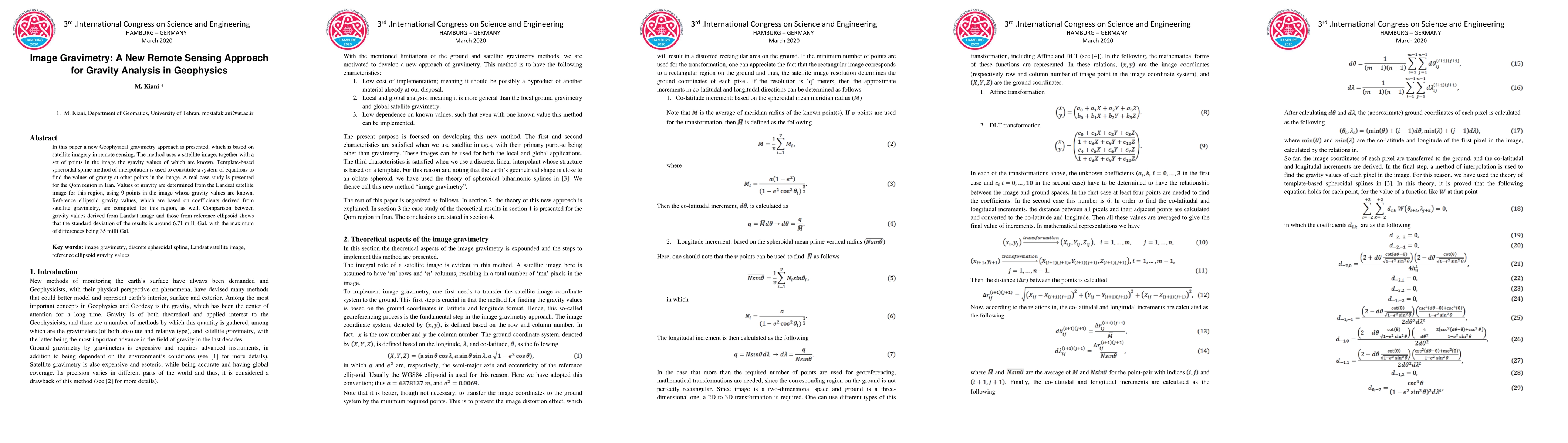
In this paper a new Geophysical gravimetry approach is presented, which is based on satellite imagery in remote sensing. The method uses a satellite image, together with a set of points in the image...

Thumbnail for Optimal Image Smoothing and Its Applications in Anomaly Detection in
  Remote Sensing
arXiv
Optimal Image Smoothing and Its Applications in Anomaly Detection in Remote Sensing

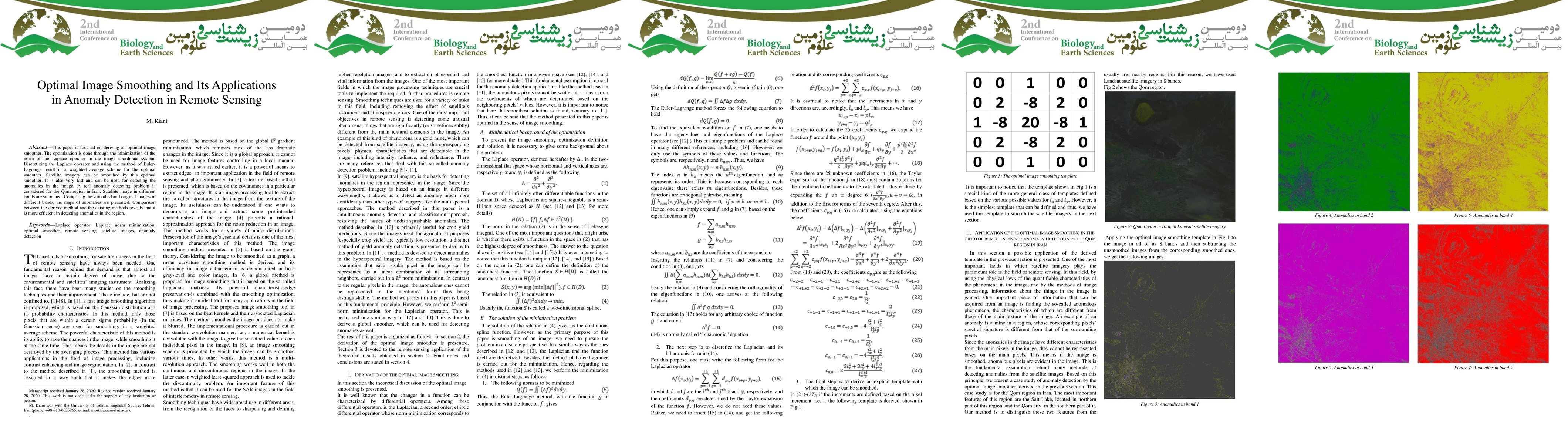
This paper is focused on deriving an optimal image smoother. The optimization is done through the minimization of the norm of the Laplace operator in the image coordinate system. Discretizing the La...

Thumbnail for Identification and Classification of Phenomena in Multispectral
  Satellite Imagery Using a New Image Smoother Method and its Applications in
  Environmental Remote Sensing
arXiv
Identification and Classification of Phenomena in Multispectral Satellite Imagery Using a New Image Smoother Method and its Applications in Environmental Remote Sensing

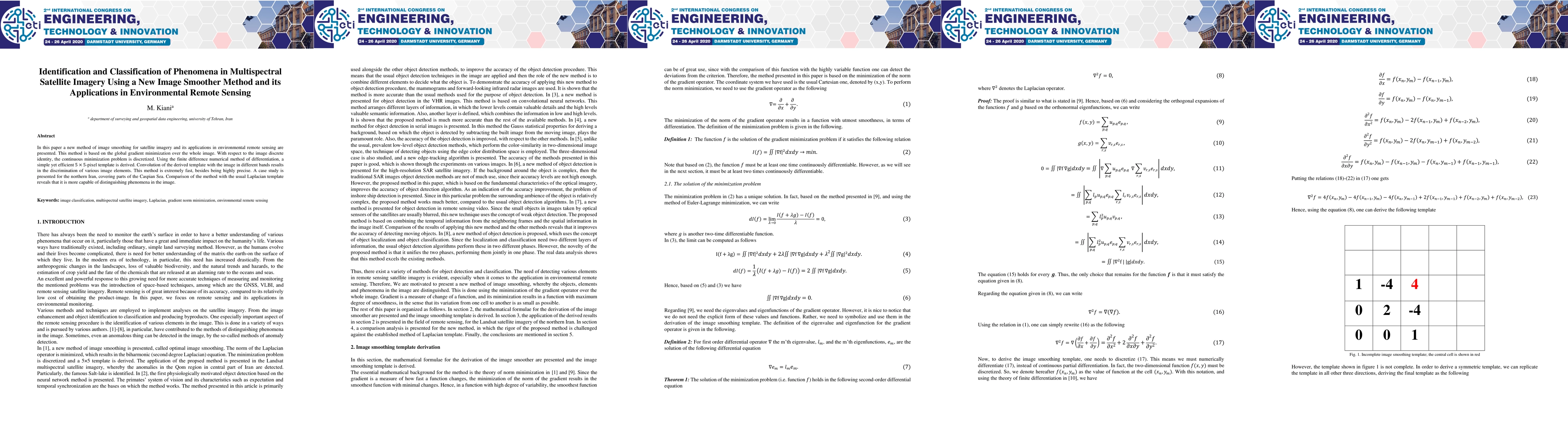
In this paper a new method of image smoothing for satellite imagery and its applications in environmental remote sensing are presented. This method is based on the global gradient minimization over ...

This website uses cookies to ensure you get the best experience. Learn more