A Dual-Branch Local-Global Framework for Cross-Resolution Land Cover Mapping
Publication
Metrics
Paper Preview
Abstract
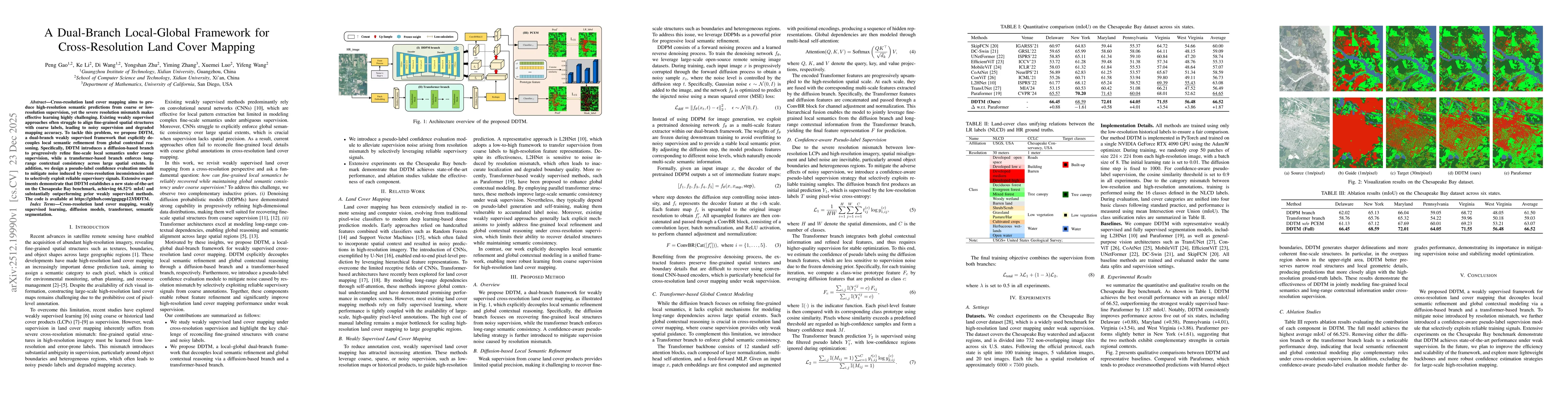
Cross-resolution land cover mapping aims to produce high-resolution semantic predictions from coarse or low-resolution supervision, yet the severe resolution mismatch makes effective learning highly challenging. Existing weakly supervised approaches often struggle to align fine-grained spatial structures with coarse labels, leading to noisy supervision and degraded mapping accuracy. To tackle this problem, we propose DDTM, a dual-branch weakly supervised framework that explicitly decouples local semantic refinement from global contextual reasoning. Specifically, DDTM introduces a diffusion-based branch to progressively refine fine-scale local semantics under coarse supervision, while a transformer-based branch enforces long-range contextual consistency across large spatial extents. In addition, we design a pseudo-label confidence evaluation module to mitigate noise induced by cross-resolution inconsistencies and to selectively exploit reliable supervisory signals. Extensive experiments demonstrate that DDTM establishes a new state-of-the-art on the Chesapeake Bay benchmark, achieving 66.52\% mIoU and substantially outperforming prior weakly supervised methods. The code is available at https://github.com/gpgpgp123/DDTM.
AI Key Findings
Get AI-generated insights about this paper's methodology, results, significance, and more — seven facets brought into focus.
Discussion 0