Summary
Accurate, cost-effective monitoring of plantation aboveground biomass (AGB) is crucial for supporting local livelihoods and carbon sequestration initiatives like the China Certified Emission Reduction (CCER) program. High-resolution canopy height maps (CHMs) are essential for this, but standard lidar-based methods are expensive. While deep learning with RGB imagery offers an alternative, accurately extracting canopy height features remains challenging. To address this, we developed a novel model for high-resolution CHM generation using a Large Vision Foundation Model (LVFM). Our model integrates a feature extractor, a self-supervised feature enhancement module to preserve spatial details, and a height estimator. Tested in Beijing's Fangshan District using 1-meter Google Earth imagery, our model outperformed existing methods, including conventional CNNs. It achieved a mean absolute error of 0.09 m, a root mean square error of 0.24 m, and a correlation of 0.78 against lidar-based CHMs. The resulting CHMs enabled over 90% success in individual tree detection, high accuracy in AGB estimation, and effective tracking of plantation growth, demonstrating strong generalization to non-training areas. This approach presents a promising, scalable tool for evaluating carbon sequestration in both plantations and natural forests.
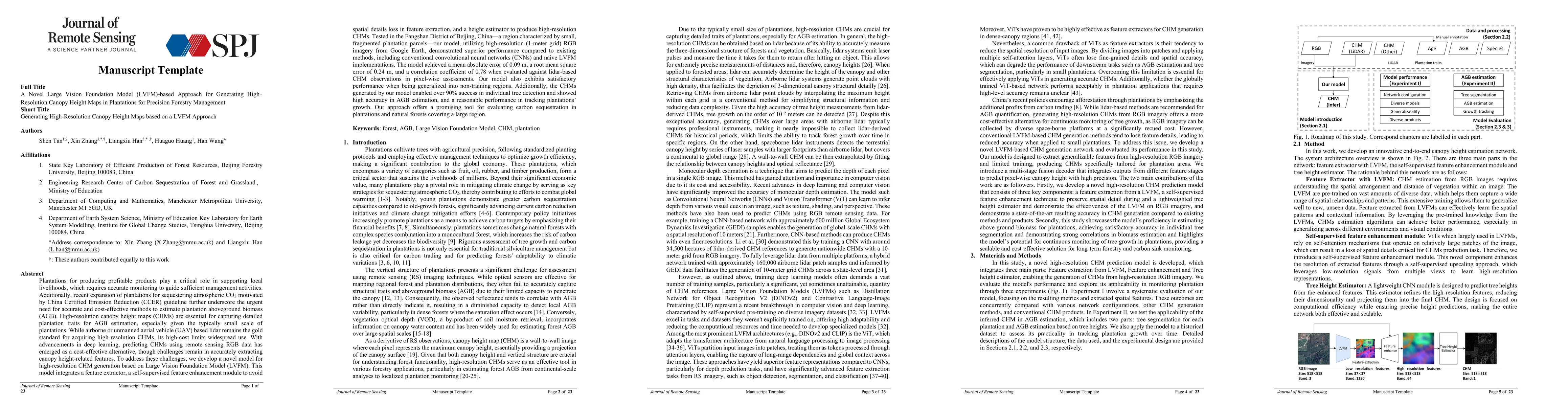
AI Key Findings
Get AI-generated insights about this paper's methodology, results, and significance.
Paper Details
PDF Preview
Citation Network
Current paper (gray), citations (green), references (blue)
Display is limited for performance on very large graphs.
Similar Papers
Found 4 papersOpen-Canopy: A Country-Scale Benchmark for Canopy Height Estimation at Very High Resolution
Philippe Ciais, Fajwel Fogel, Yohann Perron et al.
VibrantVS: A high-resolution multi-task transformer for forest canopy height estimation
Tony Chang, Kiarie Ndegwa, Andreas Gros et al.
Depth Any Canopy: Leveraging Depth Foundation Models for Canopy Height Estimation
Daniele Rege Cambrin, Isaac Corley, Paolo Garza
Vision Transformers, a new approach for high-resolution and large-scale mapping of canopy heights
Philippe Ciais, Martin Schwartz, Ibrahim Fayad et al.
No citations found for this paper.
Comments (0)