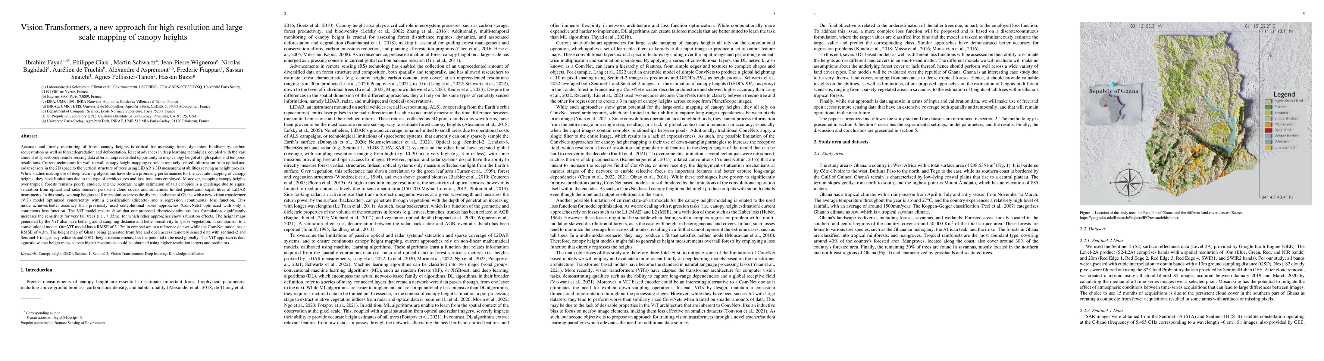
Quick Summary:

The paper introduces a vision transformer (ViT) model to map high-resolution canopy heights in Ghana, achieving better accuracy than traditional convolutional networks. The proposed discrete/continuous loss function enhances sensitivity to tall trees and sparse vegetation, reducing RMSE to 3.12m compared to 4.3m for ConvNets.

Summary

Accurate and timely monitoring of forest canopy heights is critical for assessing forest dynamics, biodiversity, carbon sequestration as well as forest degradation and deforestation. Recent advances in deep learning techniques, coupled with the vast amount of spaceborne remote sensing data offer an unprecedented opportunity to map canopy height at high spatial and temporal resolutions. Current techniques for wall-to-wall canopy height mapping correlate remotely sensed 2D information from optical and radar sensors to the vertical structure of trees using LiDAR measurements. While studies using deep learning algorithms have shown promising performances for the accurate mapping of canopy heights, they have limitations due to the type of architectures and loss functions employed. Moreover, mapping canopy heights over tropical forests remains poorly studied, and the accurate height estimation of tall canopies is a challenge due to signal saturation from optical and radar sensors, persistent cloud covers and sometimes the limited penetration capabilities of LiDARs. Here, we map heights at 10 m resolution across the diverse landscape of Ghana with a new vision transformer (ViT) model optimized concurrently with a classification (discrete) and a regression (continuous) loss function. This model achieves better accuracy than previously used convolutional based approaches (ConvNets) optimized with only a continuous loss function. The ViT model results show that our proposed discrete/continuous loss significantly increases the sensitivity for very tall trees (i.e., > 35m), for which other approaches show saturation effects. The height maps generated by the ViT also have better ground sampling distance and better sensitivity to sparse vegetation in comparison to a convolutional model. Our ViT model has a RMSE of 3.12m in comparison to a reference dataset while the ConvNet model has a RMSE of 4.3m.

AI Key Findings

Get AI-generated insights about this paper's methodology, results, and significance.

Paper Details

PDF Preview

Download PDF

Key Terms

height (0.218)
forest (0.218)
radar (0.176)
loss function (0.174)
mapping (0.167)
loss (0.166)
saturation (0.156)
trees (0.153)
optimized (0.151)
sensors (0.150)
wall (0.148)
continuous (0.139)
accurate (0.139)
convolutional (0.137)
sensitivity (0.136)
deep learning (0.130)
better (0.130)
map (0.124)
discrete (0.118)
comparison (0.116)

Citation Network

Current paper (gray), citations (green), references (blue)

Current Paper
Citations
References
Click to view
Title Authors Year Actions
Assessment and improvement of GEDI canopy height estimation in tropical and temperate forests
Myung-Sik Cho, David P. Roy, H. Kashongwe, Lin Yan, Meicheng Shen
2025
View Paper
Estimating canopy height in tropical forests: Integrating airborne LiDAR and multi-spectral optical data with machine learning
Brianna J. Pickstone, Hugh A. Graham, Andrew M. Cunliffe
2025
View Paper
Automatic Mapping of 10 m Tropical Evergreen Forest Cover in Central African Republic with Sentinel-2 Dynamic World Dataset
Wenqiong Zhao, Xinyan Zhong, Xiaodong Li, Xia Wang, Yun Du, Yihang Zhang
2025
View Paper
Canopy height model and NAIP imagery pairs across CONUS
Brady W Allred, Sarah E. McCord, S. Morford
2025
View Paper
Remote-sensing-based forest canopy height mapping: some models are useful, but might they provide us with even more insights when combined?
Nikola Besic, Nicolas Picard, Cédric Vega, J. Bontemps, Lionel Hertzog, Jean-Pierre Renaud, Fajwel Fogel, Martin Schwartz, Agnès Pellissier-Tanon, Gabriel Destouet, Frédéric Mortier, Milena Planells-Rodriguez, P. Ciais
2025
View Paper
Monitoring changes of forest height in California
Samuel Favrichon, Jake Lee, Yan Yang, Ricardo Dalagnol, F. Wagner, S. B. Le, Sassan Saatchi
2025
View Paper
High Resolution Tree Height Mapping of the Amazon Forest using Planet NICFI Images and LiDAR-Informed U-Net Model
F. Wagner, Ricardo Dalagnol, Griffin Carter, Mayumi C. M. Hirye, Shivraj Gill, S. B. Le, Samuel Favrichon, Michael Keller, J. P. Ometto, Lorena Alves, Cynthia Creze, Stephanie P. George‐Chacón, Shuang Li, Zhihua Liu, Adugna G. Mullissa, Yan Yang, Erone G Santos, Sarah R Worden, Martin Brandt, Philippe Ciais, Stephen C Hagen, Sassan Saatchi
2025
View Paper
A Comprehensive Evaluation of Deep Vision Transformers for Road Extraction from Very-high-resolution Satellite Data
Jan Bolcek, M. B. Gibril, R. Al-Ruzouq, Abdallah Shanableh, R. Jena, N. Hammouri, Mourtadha Sarhan Sachit, O. Ghorbanzadeh
2024
View Paper
Canopy height mapping in French Guiana using multi-source satellite data and environmental information in a U-Net architecture
Kamel Lahssini, Nicolas Baghdadi, Guerric le Maire, Ibrahim Fayad, Ludovic Villard
2024
View Paper
Enhancing high-resolution forest stand mean height mapping in China through an individual tree-based approach with close-range lidar data
Yuling Chen, Haitao Yang, Zekun Yang, Qiuli Yang, Weiyan Liu, Guoran Huang, Yu Ren, K. Cheng, Tianyu Xiang, Mengxi Chen, Danyang Lin, Zhiyong Qi, Jiachen Xu, Yixuan Zhang, Guangcai Xu, Qinghua Guo
2024
View Paper
Canopy Height Estimation in Brazilian Amazon using Multisource Remote Sensing Datasets
Paola Edith Ayma Quirita, Abdigal Gabriel Camargo Barra, L. M. P. Navarro, Amanda Lucas Pereira, José David Bermúdez Castro, Manoela Kohler, Marco Pacheco
2024
View Paper
Diverse Geographical Regions Based Biodiversity Conservation by LiDAR Image with Deep Learning Model
Gireesh Babu C. N., Chilukala Mahender Reddy, Mungara Kiran Kumar, Komatigunta Nagaraju, G. U. Maheswari, Ajmeera Kiran
2024
View Paper
Design, Performance, and Applications of AMMIS: A Novel Airborne Multimodular Imaging Spectrometer for High-Resolution Earth Observations
Jianxin Jia, Yueming Wang, Xiaorou Zheng, Liyin Yuan, Chunlai Li, Yi Cen, Fuqi Si, Gang Lv, Chongru Wang, Shengwei Wang, Changxing Zhang, Dong Zhang, Daogang He, Xiaoqiong Zhuang, Guicheng Han, Mingyang Zhang, Juha Hyyppä, Jianyu Wang
2024
View Paper
A Novel Spatio-Temporal Vision Transformer Model for Improving Wetland Mapping Using Multi-Seasonal Sentinel Data
Mohammad Marjani, F. Mohammadimanesh, M. Mahdianpari, Eric W. Gill
2024
View Paper
Towards Releasing ViT from Pre-training
Mario Haddad-Neto, André Silva, Rayol Mendonca-Neto, Moysés Lima, Luiz Cordovil
2024
View Paper
Combining satellite and field data reveals Congo's forest types structure, functioning and composition
Juliette Picard, Maïalicah M. Nungi‐Pambu Dembi, Nicolas Barbier, Guillaume Cornu, P. Couteron, É. Forni, Gwili Gibbon, Felix Lim, P. Ploton, Robin Pouteau, Paul Tresson, Tom van Loon, G. Viennois, M. Réjou‐Méchain
2024
View Paper
Combining satellite images with national forest inventory measurements for monitoring post-disturbance forest height growth
Agnès Pellissier-Tanon, Philippe Ciais, Martin Schwartz, Ibrahim Fayad, Yidi Xu, François Ritter, Aurélien De Truchis, J. Leban
2024
View Paper
Retrieval performance of mangrove tree heights using multiple machine learning regression models and UAV-LiDAR point clouds
Bolin Fu, Linhang Jiang, Han Yao, Yingying Wei, Mingming Jia, Weiwei Sun, Yanli Yang, Tengfang Deng
2024
View Paper
Status, advancements and prospects of deep learning methods applied in forest studies
Ting Yun, Jian Li, Lingfei Ma, Ji Zhou, Ruisheng Wang, Markus P. Eichhorn, Huaiqing Zhang
2024
View Paper
Estimating Canopy Height at Scale
Jan Pauls, Max Zimmer, Una M. Kelly, Martin Schwartz, Sassan Saatchi, P. Ciais, S. Pokutta, Martin Brandt, Fabian Gieseke
2024
View Paper
Retrieval of grassland aboveground biomass across three ecoregions in China during the past two decades using satellite remote sensing technology and machine learning algorithms
Huoqi Wu, S. An, Bin Meng, Xiaoqiu Chen, Fangjun Li, Shillong Ren
2024
View Paper
Get Your Embedding Space in Order: Domain-Adaptive Regression for Forest Monitoring
Sizhuo Li, Dimitri Gominski, Martin Brandt, X. Tong, P. Ciais
2024
View Paper
A deep learning framework for 3D vegetation extraction in complex urban environments
Jiahao Wu, Qingyan Meng, Liang Gao, Linlin Zhang, Maofan Zhao, Chen Su
2024
View Paper
Assimilating Sentinel-2 data in a modified vegetation photosynthesis and respiration model (VPRM) to improve the simulation of croplands CO2 fluxes in Europe
Hassan Bazzi, Philippe Ciais, Ezzeddine Abbessi, D. Makowski, D. Santaren, E. Ceschia, A. Brut, T. Tallec, N. Buchmann, R. Maier, Manuel Acosta, Benjamin Loubet, P. Buysse, Joël Léonard, Frédéric Bornet, Ibrahim Fayad, J. Lian, Nicolas N. Baghdadi, Ricard Segura Barrero, Christian Brümmer, Marius Schmidt, B. Heinesch, M. Mauder, T. Gruenwald
2024
View Paper
Forestry Applications of Space-Borne LiDAR Sensors: A Worldwide Bibliometric Analysis
F. Aguilar, Francisco A. Rodríguez, M. A. Aguilar, A. Nemmaoui, Flor Álvarez-Taboada
2024
View Paper
FORMS: Forest Multiple Source height, wood volume, and biomass maps in France at 10 to 30 m resolution based on Sentinel-1, Sentinel-2, and Global Ecosystem Dynamics Investigation (GEDI) data with a deep learning approach
Martin Schwartz, P. Ciais, Aurélien De Truchis, Jérôme Chave, Catherine Ottlé, Cédric Vega, J. Wigneron, Manuel Nicolas, Sami Jouaber, Siyu Liu, Martin Brandt, Ibrahim Fayad
2023
View Paper
Assessing the potential of machine learning and integrated satellite data for canopy height mapping: a case study on the Iberian Peninsula
Gonzalo Otón, Samuele Capobianco, M. Girardello, G. Ceccherini, M. Piccardo, Mark Pickering, Agata Elia, M. Migliavacca, A. Cescatti
2023
View Paper
Sub-Meter Tree Height Mapping of California using Aerial Images and LiDAR-Informed U-Net Model
F. Wagner, S. Roberts, Alison L. Ritz, Griffin Carter, Ricardo Dalagnol, Samuel Favrichon, Mayumi C. M. Hirye, M. Brandt, Philipe Ciais, Sassan Saatchi
2023
View Paper
Very high resolution canopy height maps from RGB imagery using self-supervised vision transformer and convolutional decoder trained on aerial lidar
James M. Tolan, Hung-I Yang, Ben Nosarzewski, Guillaume Couairon, Huy Q. Vo, J. Brandt, Justine Spore, S. Majumdar, Daniel Haziza, Janaki Vamaraju, Théo Moutakanni, Piotr Bojanowski, T. Johns, Brian White, T. Tiecke, C. Couprie
2023
View Paper
FORMS: Forest Multiple Source height, wood volume, and biomass maps in France at 10 to 30 m resolution based on Sentinel-1, Sentinel-2, and GEDI data with a deep learning approach
Martin Schwartz, P. Ciais, A. D. Truchis, J. Chave, C. Ottlé, Cédric Vega, J. Wigneron, M. Nicolas, Sami Jouaber, Siyu Liu, M. Brandt, Ibrahim Fayad
2023
View Paper

Comments (0)

This website uses cookies to ensure you get the best experience. Learn more