Academic Profile
Statistics
Similar Authors
Papers on arXiv
Estimating canopy height and canopy height change at meter resolution from satellite imagery has numerous applications, such as monitoring forest health, logging activities, wood resources, and carbon...
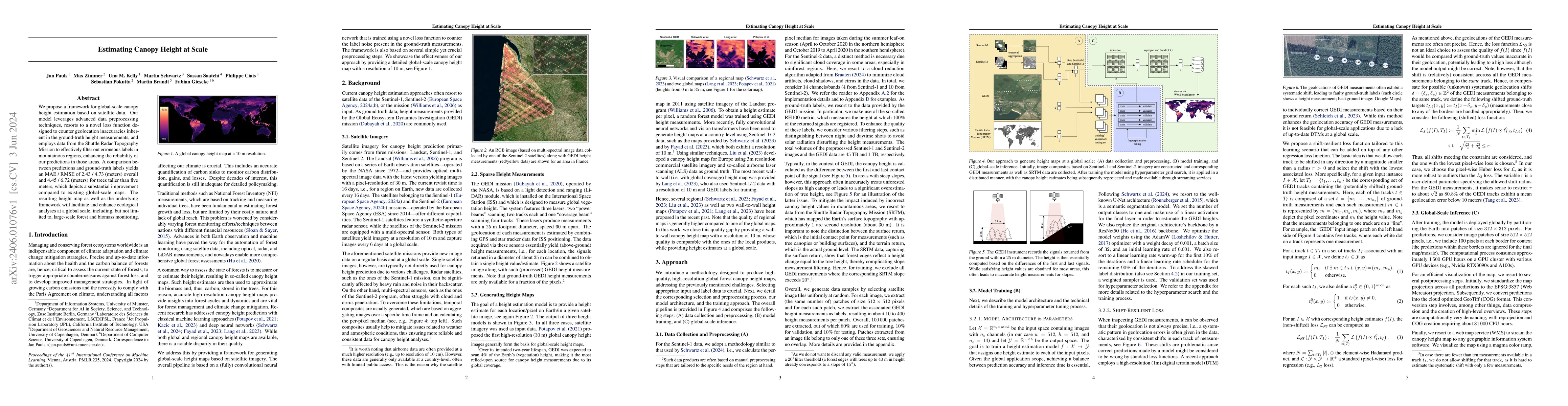
We propose a framework for global-scale canopy height estimation based on satellite data. Our model leverages advanced data preprocessing techniques, resorts to a novel loss function designed to cou...
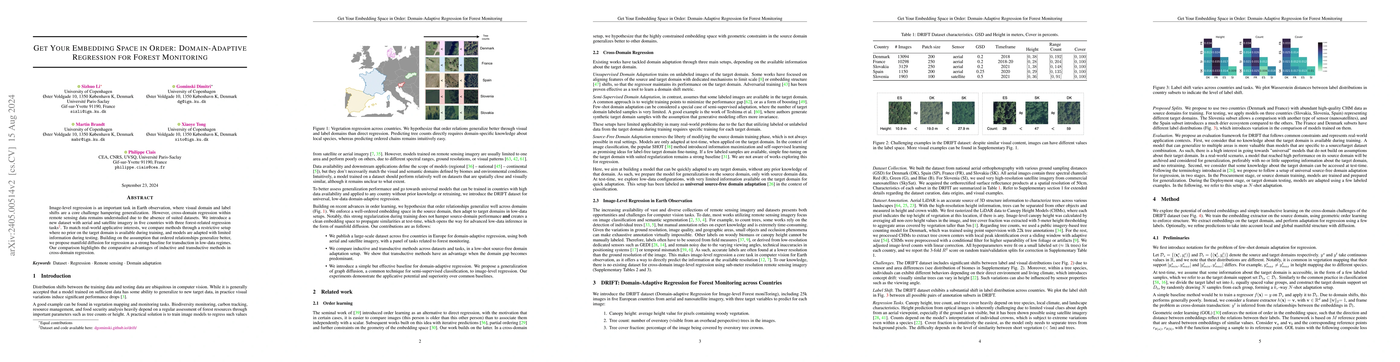
Image-level regression is an important task in Earth observation, where visual domain and label shifts are a core challenge hampering generalization. However, cross-domain regression with remote sen...
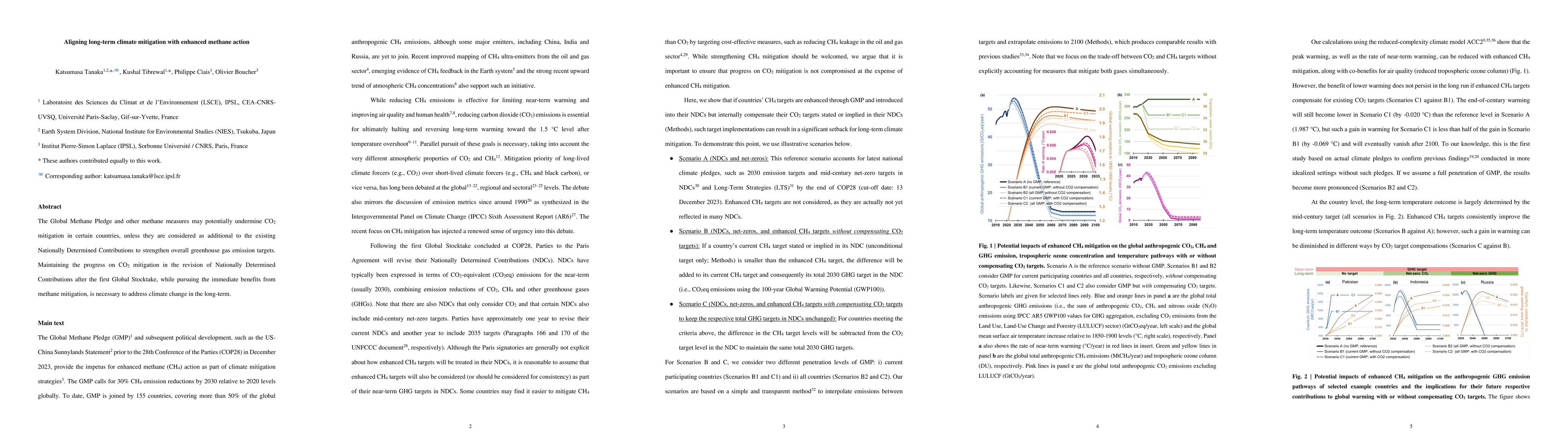
The Global Methane Pledge and other methane measures may potentially undermine CO2 mitigation in certain countries, unless they are considered as additional to the existing Nationally Determined Con...
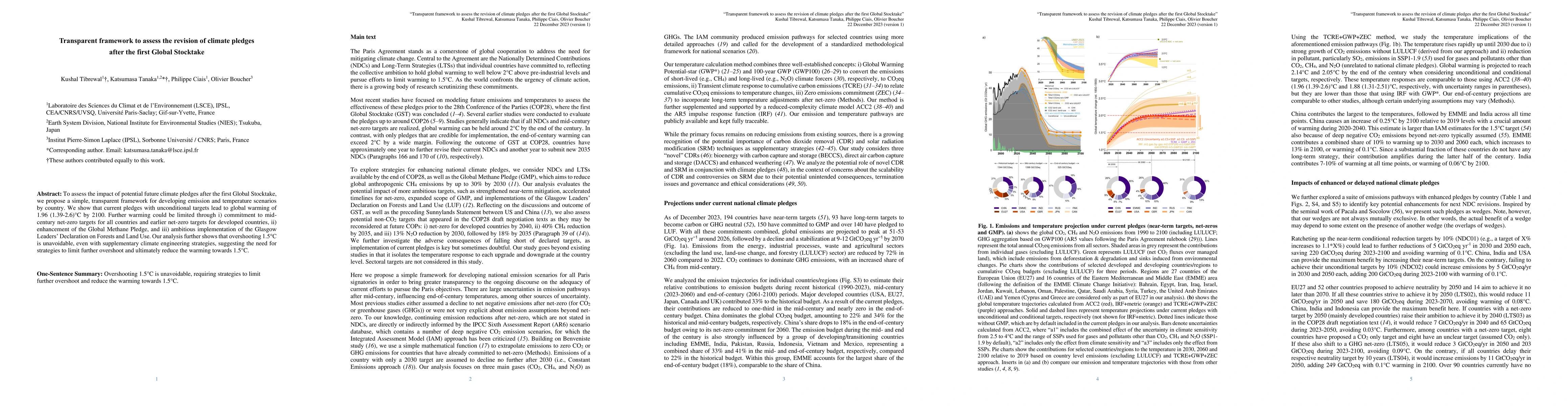
To assess the impact of potential future climate pledges after the first Global Stocktake, we propose a simple, transparent framework for developing emission and temperature scenarios by country. We...
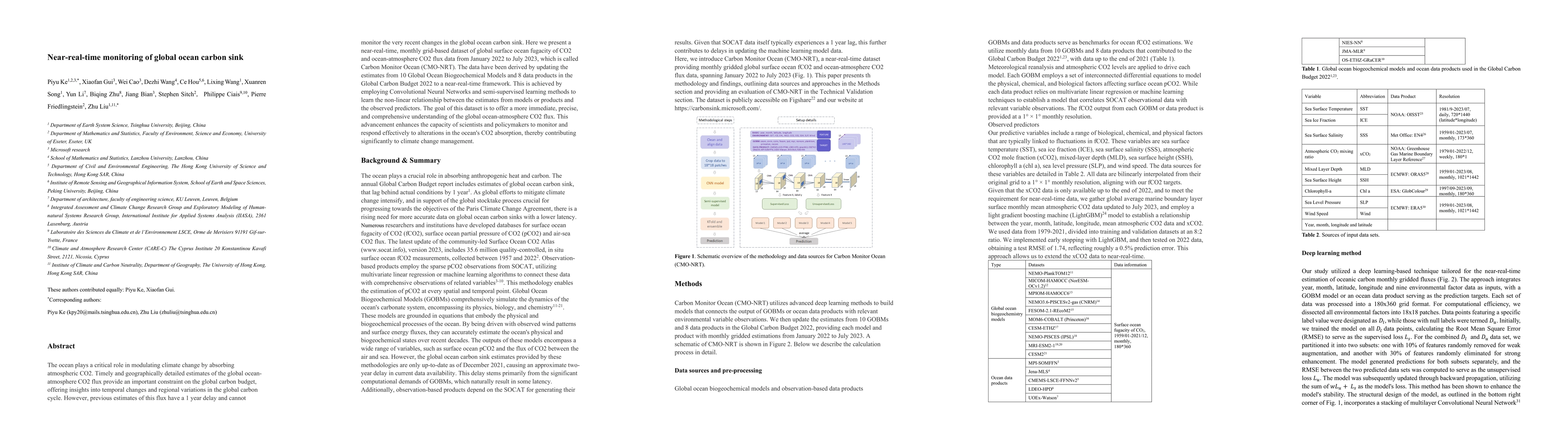
Mitigation of climate change will highly rely on a carbon emission trajectory that achieves carbon neutrality by the 2050s. The ocean plays a critical role in modulating climate change by sequesteri...
Urban decarbonization is one of the pillars for strategies to achieve carbon neutrality around the world. However, the current speed of urban decarbonization is insufficient to keep pace with effort...
Accurate and timely monitoring of forest canopy heights is critical for assessing forest dynamics, biodiversity, carbon sequestration as well as forest degradation and deforestation. Recent advances...
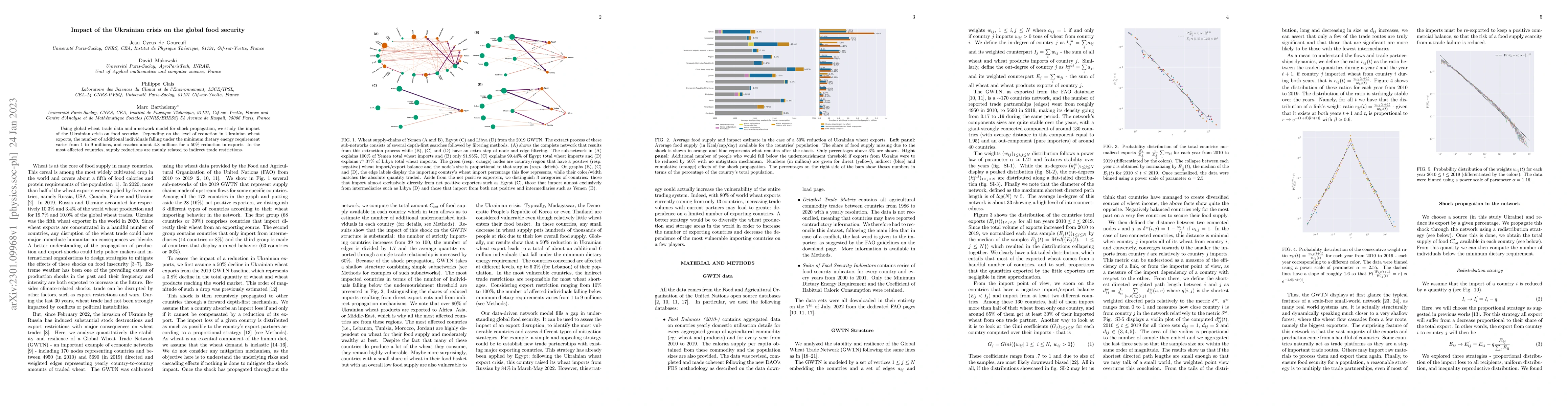
Using global wheat trade data and a network model for shock propagation, we study the impact of the Ukrainian crisis on food security. Depending on the level of reduction in Ukrainian wheat exports,...
We developed an emulator for Integrated Assessment Models (emIAM) based on a marginal abatement cost (MAC) curve approach. Using the output of IAMs in the ENGAGE Scenario Explorer and the GET model,...
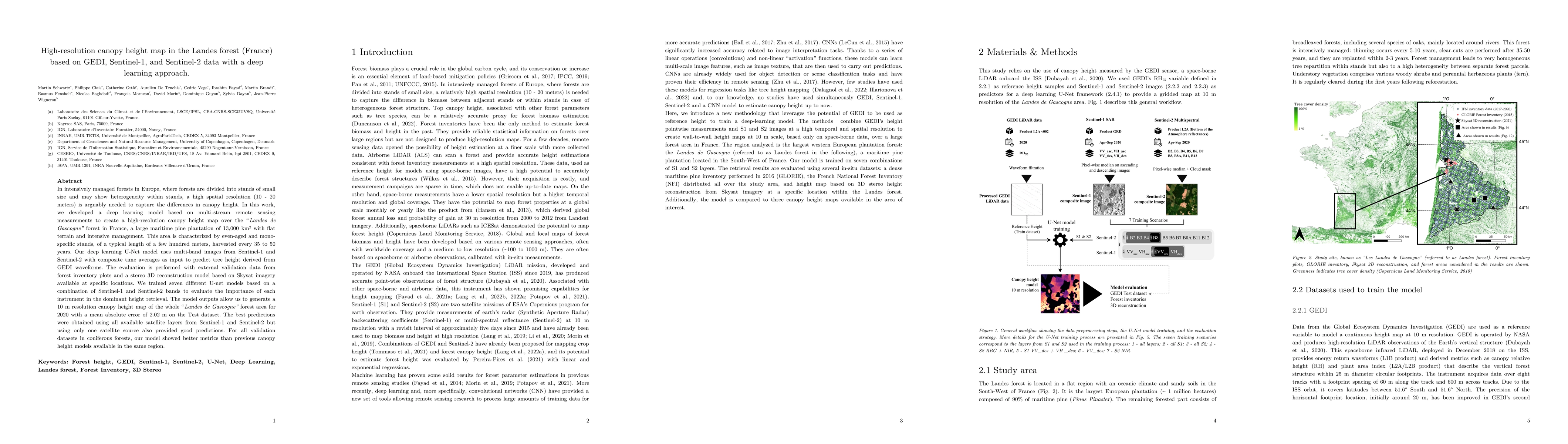
In intensively managed forests in Europe, where forests are divided into stands of small size and may show heterogeneity within stands, a high spatial resolution (10 - 20 meters) is arguably needed ...
With the urgent need to implement the EU countries pledges and to monitor the effectiveness of Green Deal plan, Monitoring Reporting and Verification tools are needed to track how emissions are chan...
We present a near-real-time global gridded daily CO$_2$ emissions dataset (GRACED) throughout 2021. GRACED provides gridded CO$_2$ emissions at a 0.1degree*0.1degree spatial resolution and 1-day tem...
We constructed a frequently updated, near-real-time global power generation dataset: Carbon Monitor-Power since January, 2016 at national levels with near-global coverage and hourly-to-daily time re...
Spatial-temporal dynamics of aboveground biomass (AGB) and forest area affect the carbon cycle, climate, and biodiversity in the Brazilian Amazon. Here we investigate inter-annual changes of AGB and...
Building on near-real-time and spatially explicit estimates of daily carbon dioxide (CO2) emissions, here we present and analyze a new city-level dataset of fossil fuel and cement emissions. Carbon ...
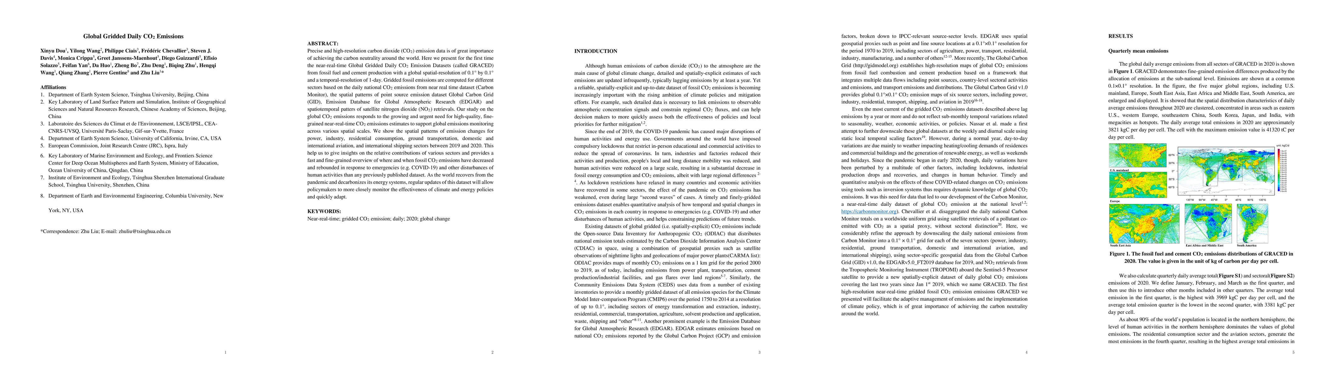
Precise and high-resolution carbon dioxide (CO$_2$) emission data is of great importance of achieving the carbon neutrality around the world. Here we present for the first time the near-real-time Gl...
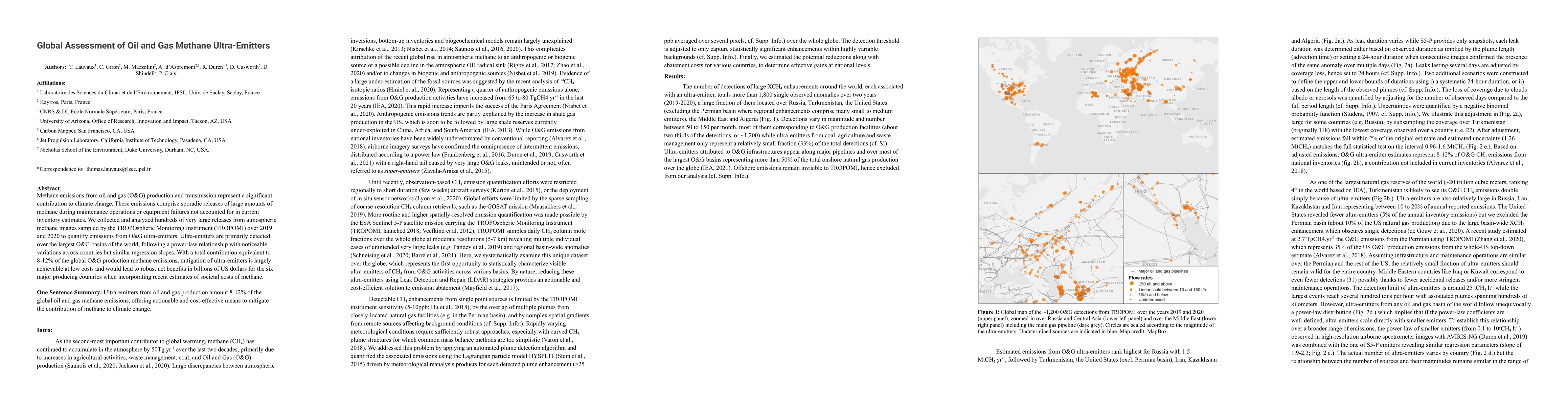
Methane emissions from oil and gas (O&G) production and transmission represent a significant contribution to climate change. These emissions comprise sporadic releases of large amounts of methane du...
As the COVID-19 virus spread over the world, governments restricted mobility to slow transmission. Public health measures had different intensities across European countries but all had significant ...
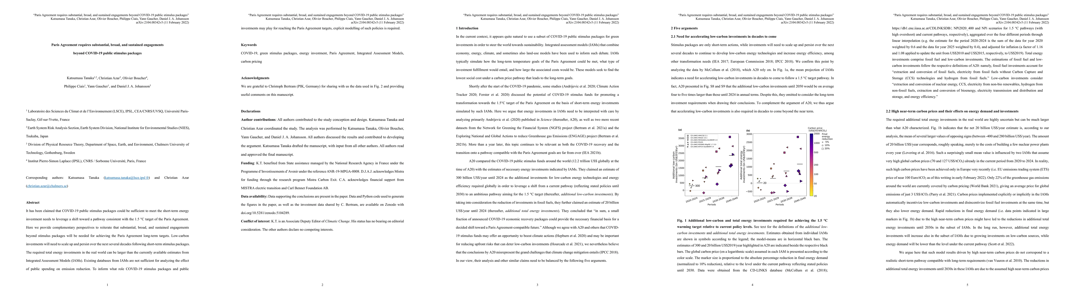
It has been claimed that COVID-19 public stimulus packages could be sufficient to meet the short-term energy investment needs to leverage a shift toward a pathway consistent with the 1.5 degrees C t...
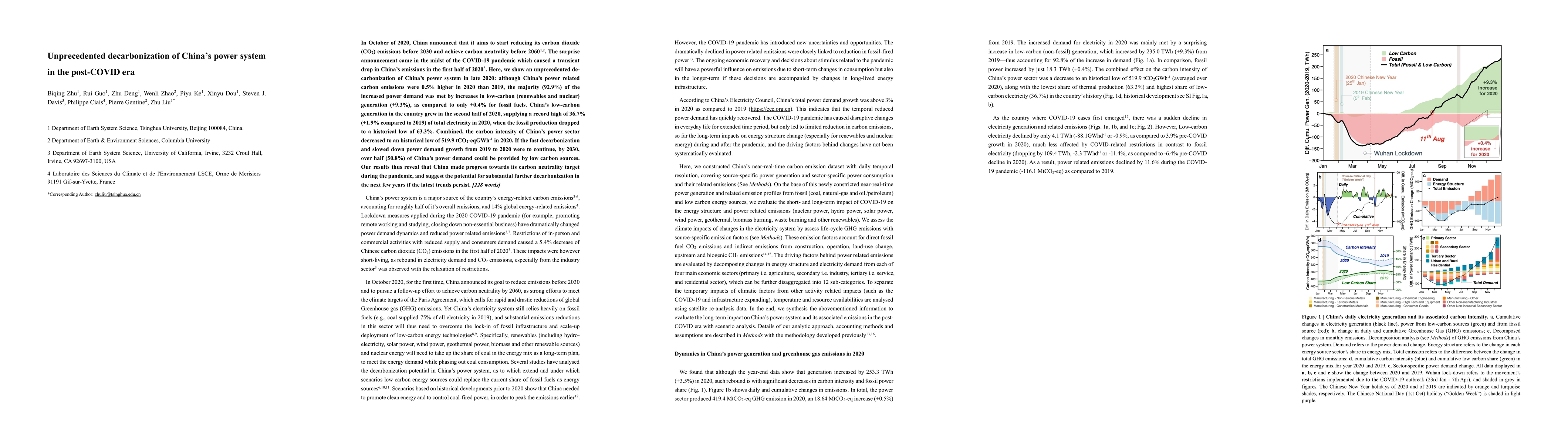
In October of 2020, China announced that it aims to start reducing its carbon dioxide (CO2) emissions before 2030 and achieve carbon neutrality before 20601. The surprise announcement came in the mi...
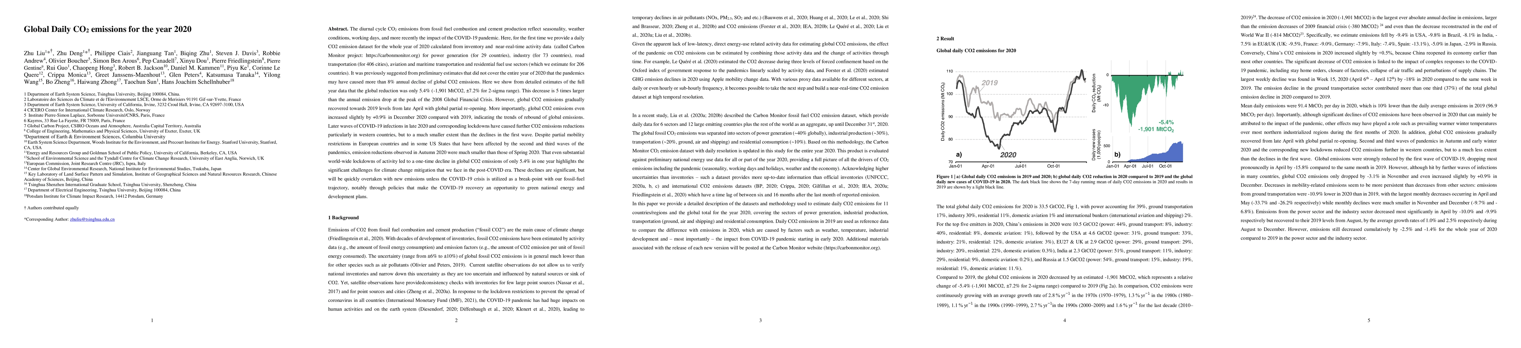
The diurnal cycle CO$_2$ emissions from fossil fuel combustion and cement production reflect seasonality, weather conditions, working days, and more recently the impact of the COVID-19 pandemic. Her...
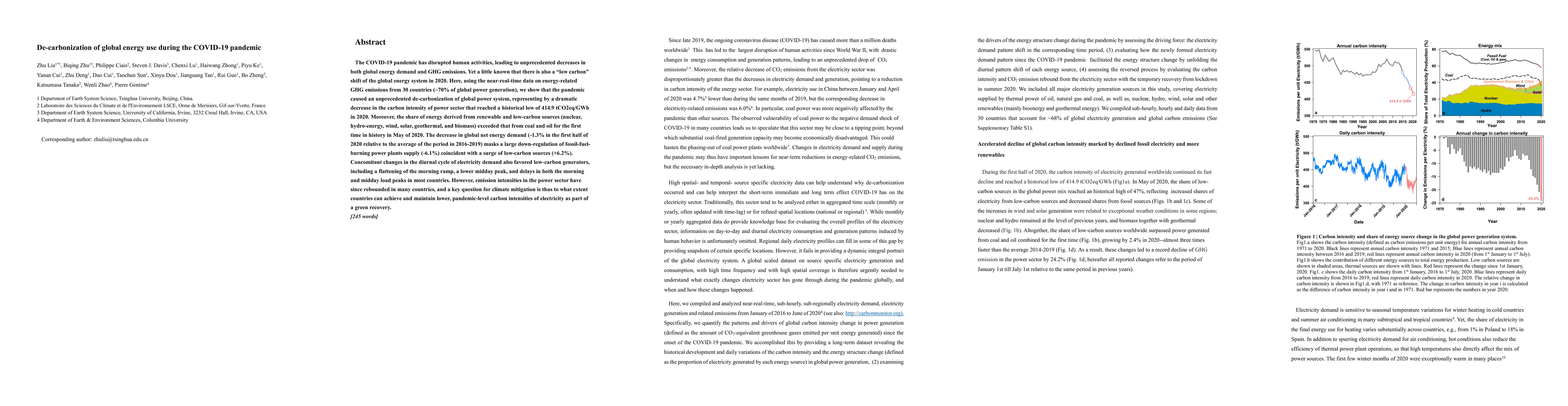
The COVID-19 pandemic has disrupted human activities, leading to unprecedented decreases in both global energy demand and GHG emissions. Yet a little known that there is also a low carbon shift of t...
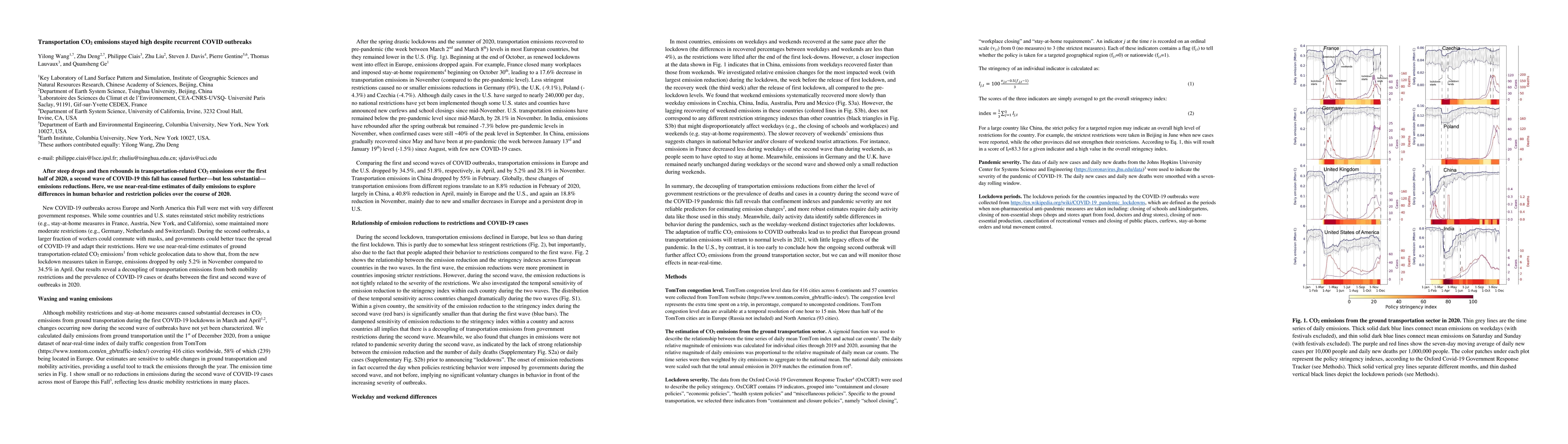
After steep drops and then rebounds in transportation-related CO$_2$ emissions over the first half of 2020, a second wave of COVID-19 this fall has caused further -- but less substantial -- emission...
Changes in CO$_2$ emissions during the COVID-19 pandemic have been estimated from indicators on activities like transportation and electricity generation. Here, we instead use satellite observations...
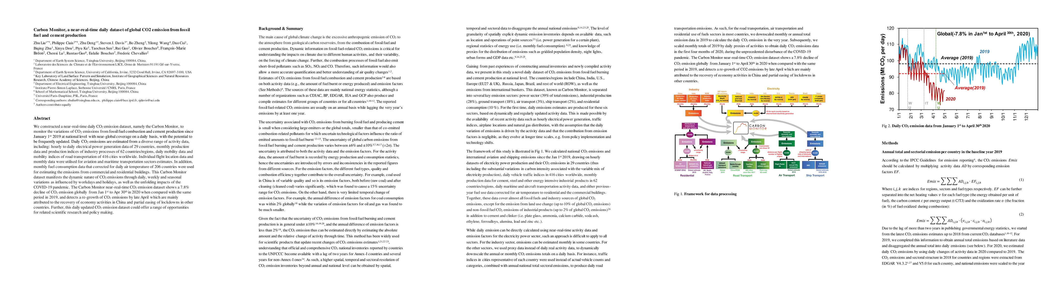
We constructed a near-real-time daily CO2 emission dataset, namely the Carbon Monitor, to monitor the variations of CO2 emissions from fossil fuel combustion and cement production since January 1st ...
The considerable cessation of human activities during the COVID-19 pandemic has affected global energy use and CO2 emissions. Here we show the unprecedented decrease in global fossil CO2 emissions f...
High temporal resolution CO2 emission data are crucial for understanding the drivers of emission changes, however, current emission dataset is only available on a yearly basis. Here, we extended a glo...
In 2023, the CO2 growth rate was 3.37 +/- 0.11 ppm at Mauna Loa, 86% above the previous year, and hitting a record high since observations began in 1958, while global fossil fuel CO2 emissions only in...
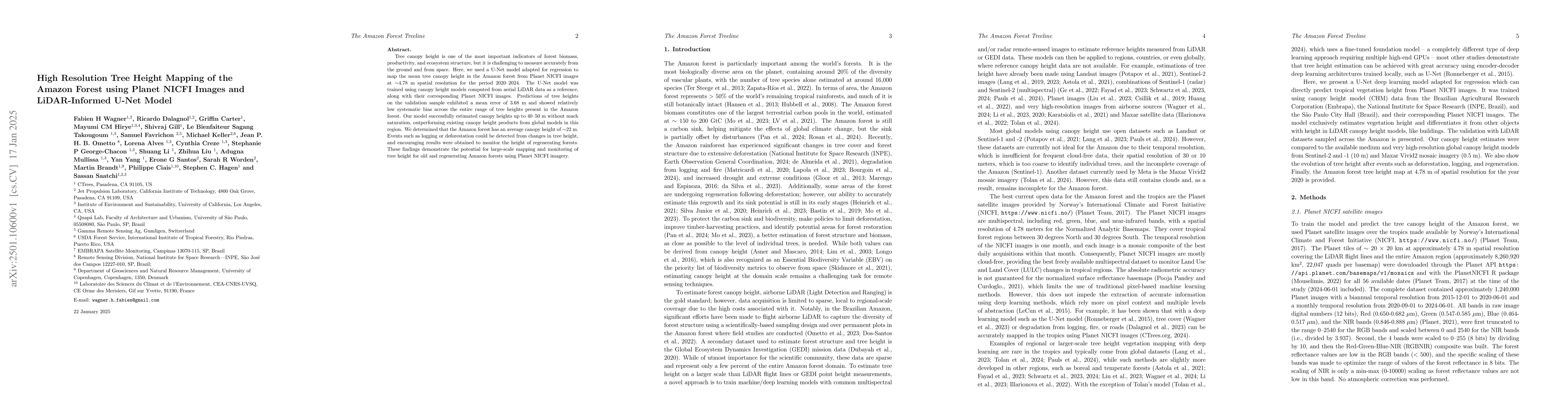
Tree canopy height is one of the most important indicators of forest biomass, productivity, and ecosystem structure, but it is challenging to measure accurately from the ground and from space. Here, w...
With the rise in global greenhouse gas emissions, accurate large-scale tree canopy height maps are essential for understanding forest structure, estimating above-ground biomass, and monitoring ecologi...
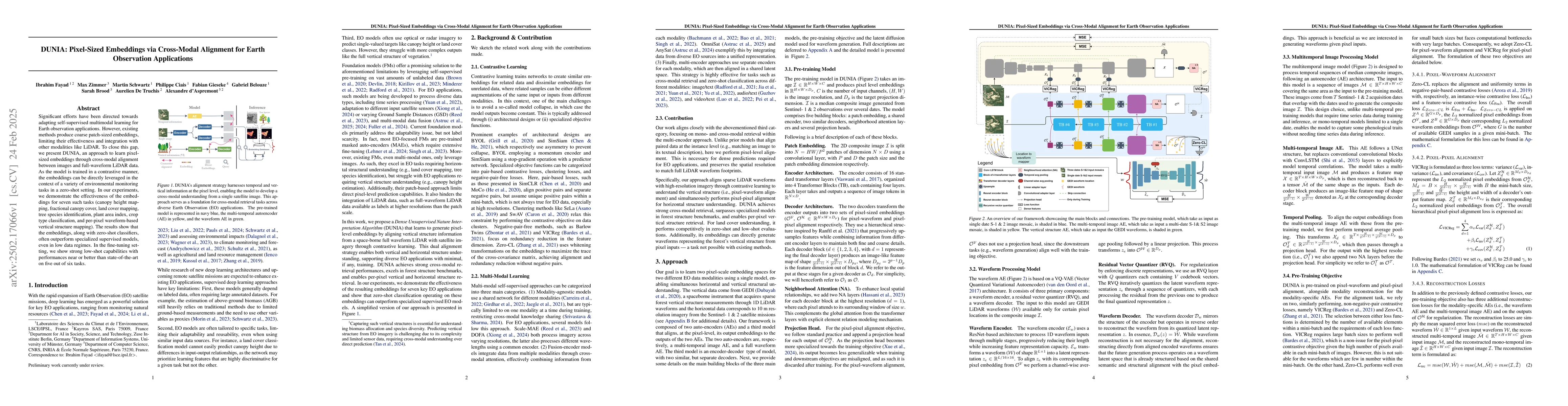
Significant efforts have been directed towards adapting self-supervised multimodal learning for Earth observation applications. However, existing methods produce coarse patch-sized embeddings, limitin...
The high growth rate of atmospheric CO2 in 2023 was found to be caused by a severe reduction of the global net land carbon sink. Here we update the global CO2 budget from January 1st to July 1st 2024,...
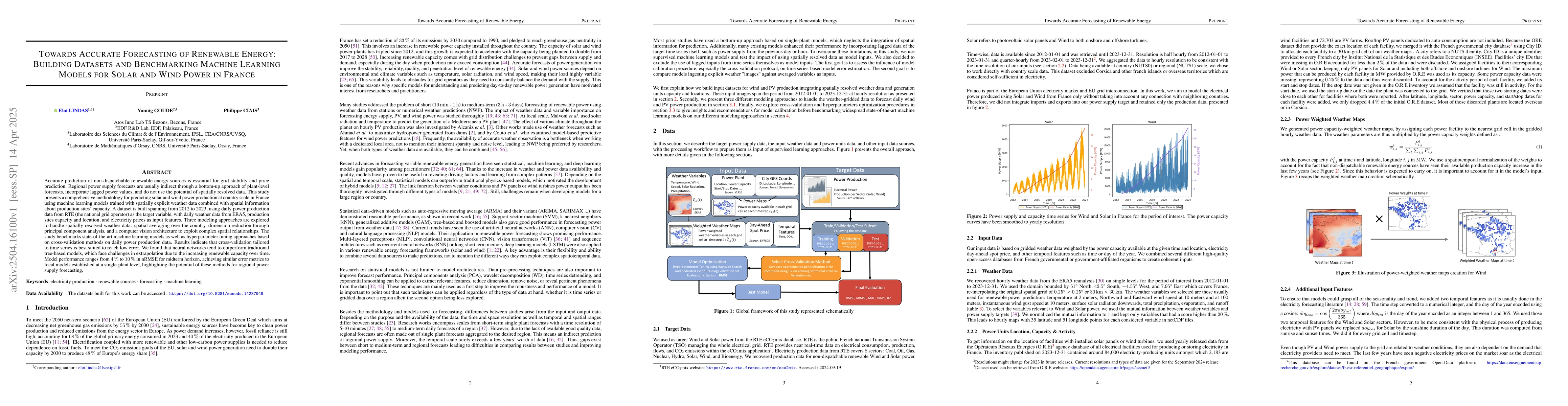
Accurate prediction of non-dispatchable renewable energy sources is essential for grid stability and price prediction. Regional power supply forecasts are usually indirect through a bottom-up approach...
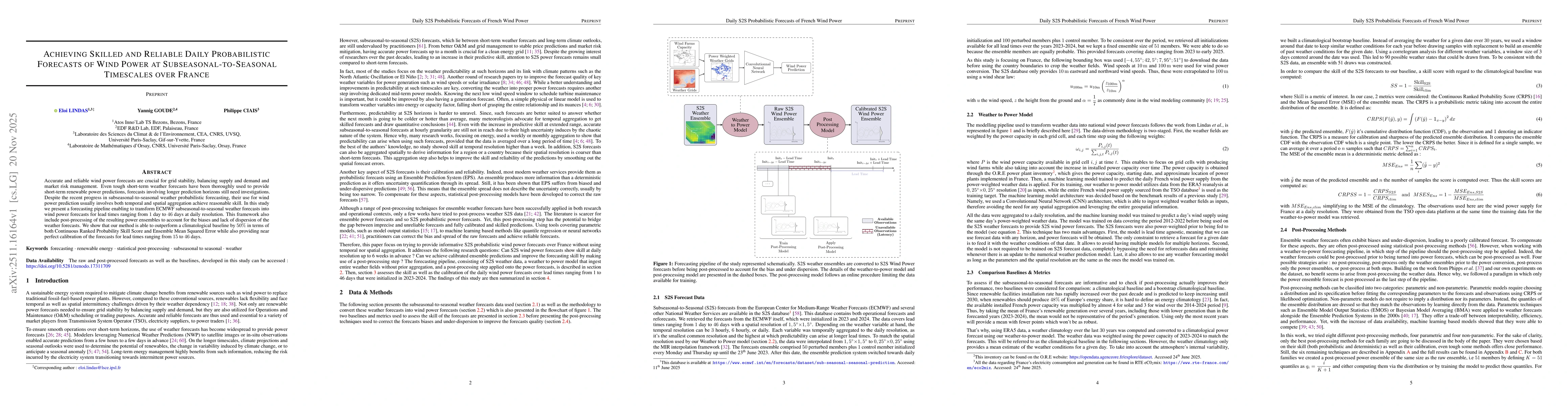
Accurate and reliable wind power forecasts are crucial for grid stability, balancing supply and demand, and market risk management. Even though short-term weather forecasts have been thoroughly used t...
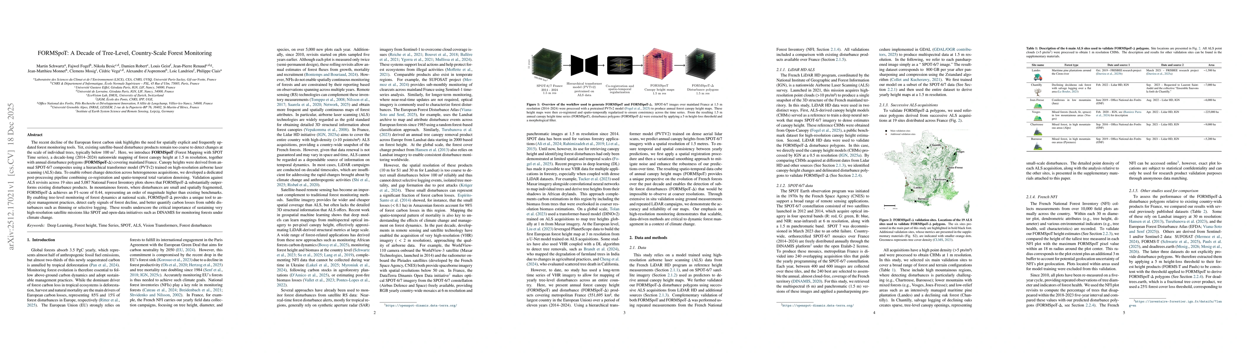
The recent decline of the European forest carbon sink highlights the need for spatially explicit and frequently updated forest monitoring tools. Yet, existing satellite-based disturbance products rema...
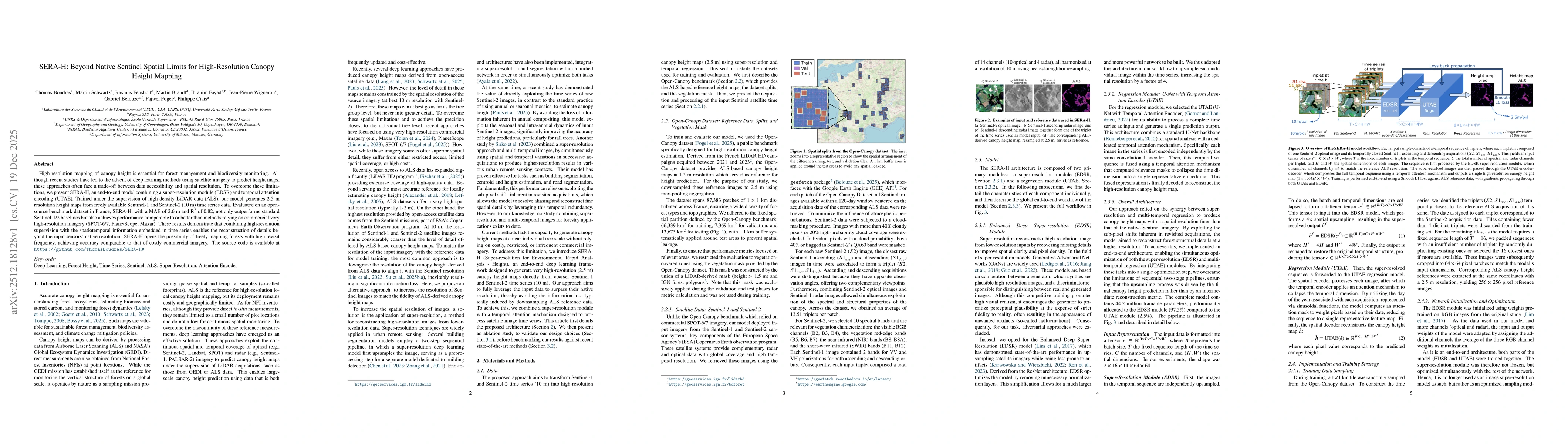
High-resolution mapping of canopy height is essential for forest management and biodiversity monitoring. Although recent studies have led to the advent of deep learning methods using satellite imagery...
Atmospheric Methane Removal (AMR) is a third class of climate intervention, along with Carbon Dioxide Removal (CDR) and Solar Radiation Management (SRM). We show that, unlike CDR, the avoided warming ...
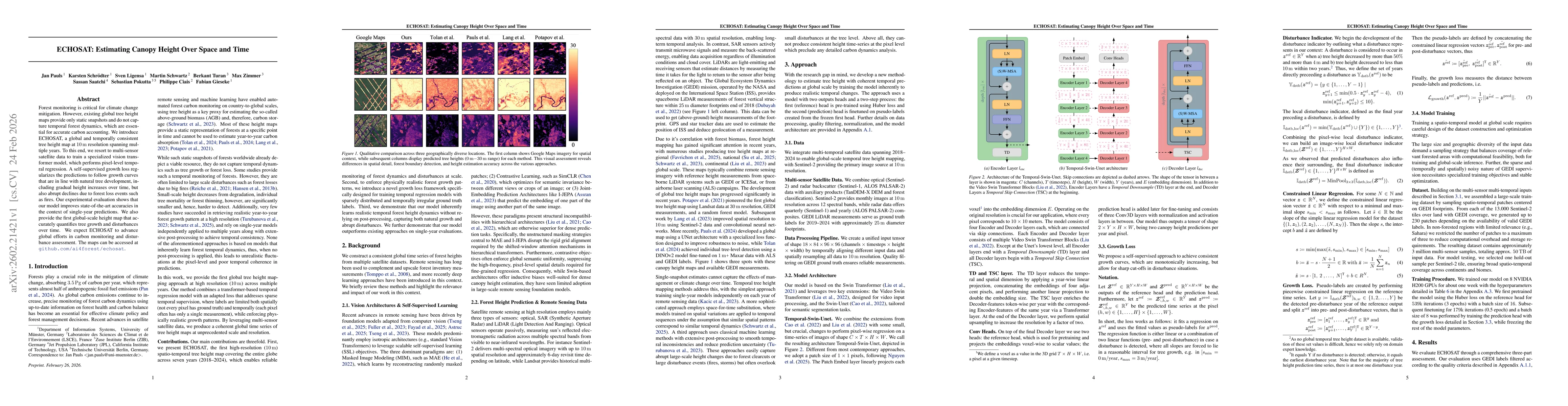
Forest monitoring is critical for climate change mitigation. However, existing global tree height maps provide only static snapshots and do not capture temporal forest dynamics, which are essential fo...