DUNIA: Pixel-Sized Embeddings via Cross-Modal Alignment for Earth Observation Applications

Source: ArXiv

AI Quick Summary

DUNIA presents a method to generate pixel-sized embeddings via cross-modal alignment between images and LiDAR data for Earth observation. These embeddings enable zero-shot performance in various environmental monitoring tasks, often surpassing specialized supervised models.

Share: Share on X LinkedIn

Summary

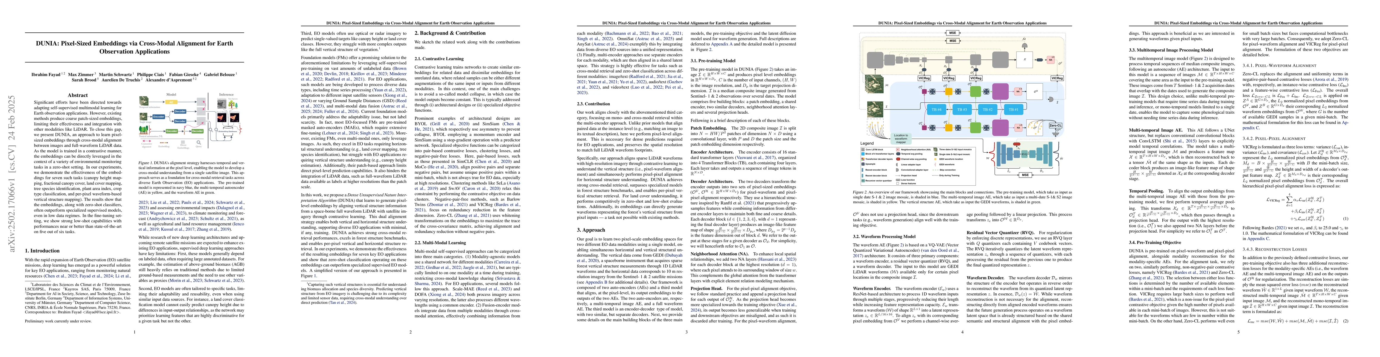
Significant efforts have been directed towards adapting self-supervised multimodal learning for Earth observation applications. However, existing methods produce coarse patch-sized embeddings, limiting their effectiveness and integration with other modalities like LiDAR. To close this gap, we present DUNIA, an approach to learn pixel-sized embeddings through cross-modal alignment between images and full-waveform LiDAR data. As the model is trained in a contrastive manner, the embeddings can be directly leveraged in the context of a variety of environmental monitoring tasks in a zero-shot setting. In our experiments, we demonstrate the effectiveness of the embeddings for seven such tasks (canopy height mapping, fractional canopy cover, land cover mapping, tree species identification, plant area index, crop type classification, and per-pixel waveform-based vertical structure mapping). The results show that the embeddings, along with zero-shot classifiers, often outperform specialized supervised models, even in low data regimes. In the fine-tuning setting, we show strong low-shot capabilities with performances near or better than state-of-the-art on five out of six tasks.

AI Key Findings

Generated Jun 11, 2025

Methodology

The research introduces DUNIA, a self-supervised approach for learning pixel-sized embeddings via cross-modal alignment between satellite images and LiDAR data. It employs a contrastive learning strategy, enabling zero-shot transferability for various environmental monitoring tasks.

Key Results

  • DUNIA embeddings outperform specialized supervised models in low data regimes for tasks like canopy height mapping, fractional canopy cover, land cover mapping, tree species identification, plant area index, crop type classification, and per-pixel waveform-based vertical structure mapping.
  • In fine-tuning, DUNIA demonstrates strong low-shot capabilities, achieving near or better performance than state-of-the-art methods on five out of six tasks.
  • The approach adapts well to varying input resolutions, benefiting Earth observation applications with diverse spatial resolutions.

Significance

This research is significant as it closes the gap in existing methods that produce coarse patch-sized embeddings, enhancing the integration of LiDAR data with other modalities for Earth observation applications.

Technical Contribution

DUNIA presents a novel self-supervised learning method for generating pixel-sized embeddings through cross-modal alignment of satellite imagery and LiDAR data, facilitating zero-shot transfer for multiple environmental monitoring tasks.

Novelty

DUNIA distinguishes itself by focusing on pixel-sized embeddings, contrastive learning for cross-modal alignment, and zero-shot transferability for various Earth observation tasks, surpassing existing patch-based approaches.

Limitations

  • The study does not extensively evaluate the model's performance on diverse geographical regions or under varying atmospheric conditions.
  • Limited exploration of computational efficiency and scalability for large-scale Earth observation datasets.

Future Work

  • Investigate the model's performance across diverse geographical regions and under varying atmospheric conditions.
  • Explore methods to improve computational efficiency and scalability for handling massive Earth observation datasets.

Paper Details

PDF Preview

Download PDF

Citation Network

Current paper (gray), citations (green), references (blue)

Display is limited for performance on very large graphs.

Current Paper
Citations
References
Click to view

No citations found for this paper.

Comments (0)

This website uses cookies to ensure you get the best experience. Learn more