Authors
Publication
Metrics
Quick Actions
AI Quick Summary
This research introduces a new method for generating high-resolution, temporal canopy height maps using Sentinel-2 satellite data, validated with GEDI LiDAR data. The study provides the first 10m resolution temporal canopy height map for Europe from 2019-2022, offering more precise estimates than previous studies and facilitating large-scale forest monitoring and ecological research.
Quick Answers
What is "Capturing Temporal Dynamics in Large-Scale Canopy Tree Height Estimation" about?
This research introduces a new method for generating high-resolution, temporal canopy height maps using Sentinel-2 satellite data, validated with GEDI LiDAR data. The study provides the first 10m resolution temporal canopy height map for Europe from 2019-2022, offering more precise estimates than previous studies and facilitating large-scale forest monitoring and ecological research.
What methodology did the authors use?
The research employs a 3DU-Net model utilizing a full 12-month Sentinel-2 imagery timeseries, avoiding the loss of information from median composites and capturing essential seasonal variations and geolocation shifts. The model is trained on GEDI LiDAR data to produce a 10m resolution tree canopy height map for Europe from 2019 to 2022. More in Methodology →
What are the key results?
The proposed method significantly outperforms existing state-of-the-art models, achieving substantially lower errors. — The model drastically improves accuracy for tall trees, crucial for precise biomass estimation and carbon stock assessments. More in Key Results →
Why is this work significant?
This study significantly advances forest monitoring by leveraging machine learning to incorporate temporal dynamics, resulting in tree canopy height maps over a four-year span (2019-2022) on a continental scale. The findings are crucial for effective forest management and conservation, supporting global initiatives like the UN's Sustainable Development Goals, the Bonn Challenge, and the Glasgow Declaration. More in Significance →
What are the main limitations?
The study's coarser 10m resolution of Sentinel-1/2 compared to Planet (3m) or Maxar (60cm) might affect the accuracy of height estimations for smaller trees. — Mapping minor tree growth is challenging due to the short time frame and slow natural growth rate of trees. More in Limitations →
Abstract
With the rise in global greenhouse gas emissions, accurate large-scale tree canopy height maps are essential for understanding forest structure, estimating above-ground biomass, and monitoring ecological disruptions. To this end, we present a novel approach to generate large-scale, high-resolution canopy height maps over time. Our model accurately predicts canopy height over multiple years given Sentinel-2 time series satellite data. Using GEDI LiDAR data as the ground truth for training the model, we present the first 10m resolution temporal canopy height map of the European continent for the period 2019-2022. As part of this product, we also offer a detailed canopy height map for 2020, providing more precise estimates than previous studies. Our pipeline and the resulting temporal height map are publicly available, enabling comprehensive large-scale monitoring of forests and, hence, facilitating future research and ecological analyses. For an interactive viewer, see https://europetreemap.projects.earthengine.app/view/temporalcanopyheight.
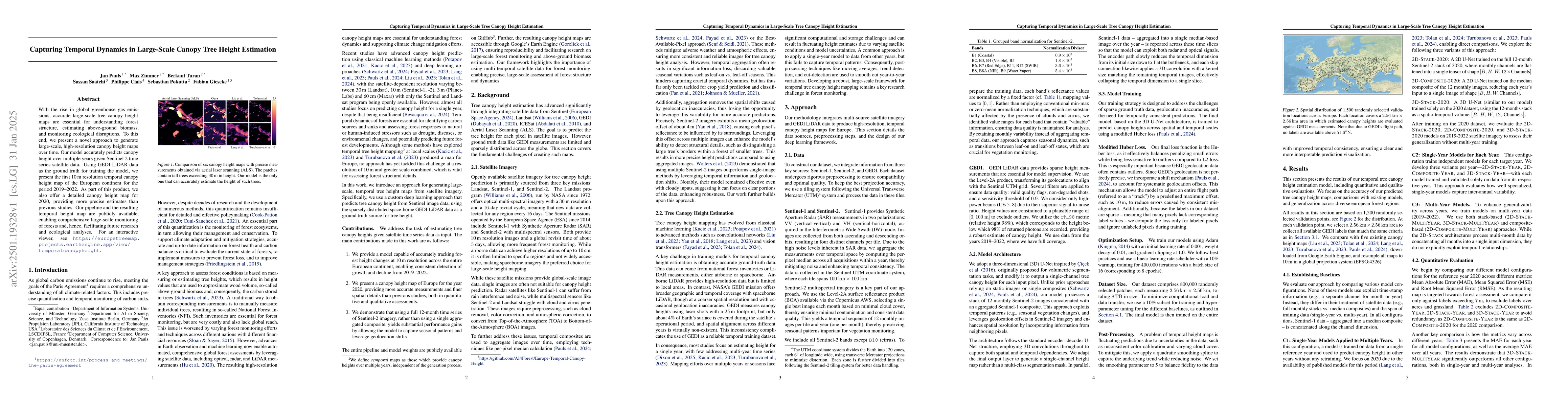
AI Key Findings
Generated Jun 12, 2025
Methodology — What approach did the authors take?
The research employs a 3DU-Net model utilizing a full 12-month Sentinel-2 imagery timeseries, avoiding the loss of information from median composites and capturing essential seasonal variations and geolocation shifts. The model is trained on GEDI LiDAR data to produce a 10m resolution tree canopy height map for Europe from 2019 to 2022.
Key Results — What are the main findings?
- The proposed method significantly outperforms existing state-of-the-art models, achieving substantially lower errors.
- The model drastically improves accuracy for tall trees, crucial for precise biomass estimation and carbon stock assessments.
- Temporal maps capture forest dynamics, such as deforestation and growth patterns, offering valuable insights for forest monitoring and ecological analyses.
Significance — Why does this research matter?
This study significantly advances forest monitoring by leveraging machine learning to incorporate temporal dynamics, resulting in tree canopy height maps over a four-year span (2019-2022) on a continental scale. The findings are crucial for effective forest management and conservation, supporting global initiatives like the UN's Sustainable Development Goals, the Bonn Challenge, and the Glasgow Declaration.
Technical Contribution — What is the technical contribution?
The development and application of a 3DU-Net model for high-resolution, large-scale temporal tree canopy height mapping using Sentinel-2 time series data.
Novelty — What is new about this work?
The research introduces a novel approach for generating high-resolution, large-scale temporal tree canopy height maps by utilizing a 3DU-Net model, capturing essential seasonal variations and geolocation shifts, and significantly improving accuracy for tall trees.
Limitations — What are the limitations of this study?
- The study's coarser 10m resolution of Sentinel-1/2 compared to Planet (3m) or Maxar (60cm) might affect the accuracy of height estimations for smaller trees.
- Mapping minor tree growth is challenging due to the short time frame and slow natural growth rate of trees.
Future Work — What did the authors propose for future work?
- Explore the integration of additional satellite data sources to enhance model performance and temporal resolution.
- Investigate the potential of incorporating other environmental factors and biotic interactions to improve the accuracy of biomass estimations.
Paper Details
How to Cite This Paper
@article{turan2025capturing,
title = {Capturing Temporal Dynamics in Large-Scale Canopy Tree Height Estimation},
author = {Turan, Berkant and Gieseke, Fabian and Pauls, Jan and others},
year = {2025},
eprint = {2501.19328},
archivePrefix = {arXiv},
primaryClass = {cs.LG},
}
Turan, B., Gieseke, F., Pauls, J., Zimmer, M., Ciais, P., Saatchi, S., & Pokutta, S. (2025). Capturing Temporal Dynamics in Large-Scale Canopy Tree Height Estimation. arXiv. https://arxiv.org/abs/2501.19328
Turan, Berkant, et al. "Capturing Temporal Dynamics in Large-Scale Canopy Tree Height Estimation." arXiv, 2025, arxiv.org/abs/2501.19328.
PDF Preview
Similar Papers
Found 4 papersOpen-Canopy: A Country-Scale Benchmark for Canopy Height Estimation at Very High Resolution
Fajwel Fogel, Yohann Perron, Nikola Besic et al.
Canopy Tree Height Estimation Using Quantile Regression: Modeling and Evaluating Uncertainty in Remote Sensing
Karsten Schrödter, Jan Pauls, Fabian Gieseke
Depth Any Canopy: Leveraging Depth Foundation Models for Canopy Height Estimation
Daniele Rege Cambrin, Isaac Corley, Paolo Garza
No citations found for this paper.
Comments (0)