Large language models (LLMs) are being used in data science code generation
tasks, but they often struggle with complex sequential tasks, leading to
logical errors. Their application to geospatial data processing is particularly
challenging due to difficulties in incorporating complex data structures and
spatial constraints, effectively utilizing diverse function calls, and the
tendency to hallucinate less-used geospatial libraries. To tackle these
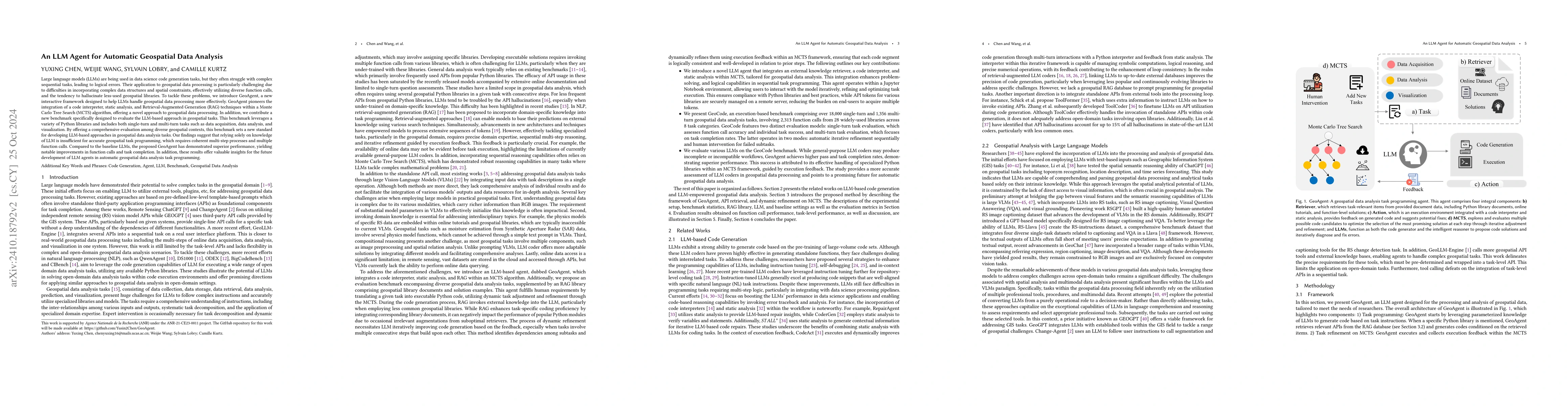
problems, we introduce GeoAgent, a new interactive framework designed to help
LLMs handle geospatial data processing more effectively. GeoAgent pioneers the
integration of a code interpreter, static analysis, and Retrieval-Augmented
Generation (RAG) techniques within a Monte Carlo Tree Search (MCTS) algorithm,
offering a novel approach to geospatial data processing. In addition, we
contribute a new benchmark specifically designed to evaluate the LLM-based
approach in geospatial tasks. This benchmark leverages a variety of Python
libraries and includes both single-turn and multi-turn tasks such as data
acquisition, data analysis, and visualization. By offering a comprehensive
evaluation among diverse geospatial contexts, this benchmark sets a new
standard for developing LLM-based approaches in geospatial data analysis tasks.
Our findings suggest that relying solely on knowledge of LLM is insufficient
for accurate geospatial task programming, which requires coherent multi-step
processes and multiple function calls. Compared to the baseline LLMs, the
proposed GeoAgent has demonstrated superior performance, yielding notable
improvements in function calls and task completion. In addition, these results
offer valuable insights for the future development of LLM agents in automatic
geospatial data analysis task programming.
Discussion 0