Assimilation of SAR-derived Flood Observations for Improving Fluvial Flood Forecast
Publication
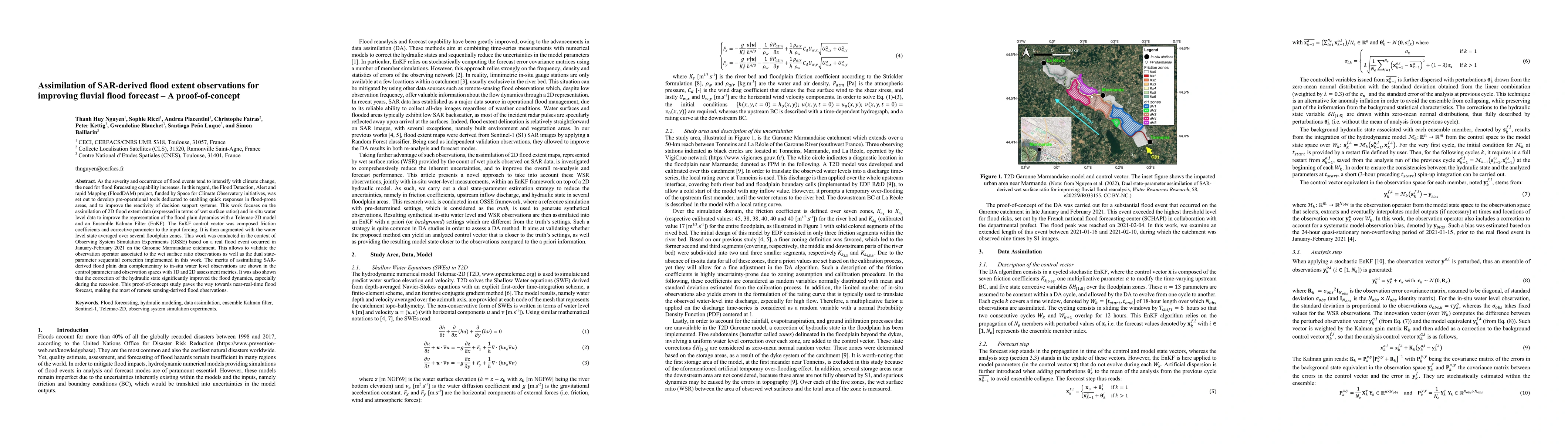
Metrics
AI Quick Summary
This study integrates Synthetic Aperture Radar (SAR)-derived flood extent data with in-situ water level observations to enhance fluvial flood forecast models using a Telemac-2D model and Ensemble Kalman Filter. The assimilation of SAR data significantly improves the representation of flood plain dynamics, particularly during the recession phase, demonstrating the potential for near-real-time flood forecasting.
Paper Preview
Abstract
As the severity and occurrence of flood events tend to intensify with climate change, the need for flood forecasting capability increases. In this regard, the Flood Detection, Alert and rapid Mapping (FloodDAM) project, funded by Space for Climate Observatory initiatives, was set out to develop pre-operational tools dedicated to enabling quick responses in flood-prone areas, and to improve the reactivity of decision support systems. This work focuses on the assimilation of 2D flood extent data (expressed in terms of wet surface ratios) and in-situ water level data to improve the representation of the flood plain dynamics with a Telemac-2D model and an Ensemble Kalman Filter (EnKF). The EnKF control vector was composed friction coefficients and corrective parameter to the input forcing. It is then augmented with the water level state averaged over several floodplain zones. This work was conducted in the context of Observing System Simulation Experiments (OSSE) based on a real flood event occurred in January-February 2021 on the Garonne Marmandaise catchment. This allows to validate the observation operator associated to the wet surface ratio observations as well as the dual state-parameter sequential correction implemented in this work. The merits of assimilating SAR- derived flood plain data complementary to in-situ water level observations are shown in the control parameter and observation spaces with 1D and 2D assessment metrics. It was also shown that the correction of the hydraulic state significantly improved the flood dynamics, especially during the recession. This proof-of-concept study paves the way towards near-real-time flood forecast, making the most of remote sensing-derived flood observations.
AI Key Findings
Get AI-generated insights about this paper's methodology, results, significance, and more — seven facets brought into focus.
Impact
Paper Details
Authors
PDF Preview
Key Terms
Citation Network
Current paper (gray), citations (green), references (blue)
Display is limited for performance on very large graphs.
Discussion 0