This paper introduces a novel method for continuous self-localization using on-board cameras and lidar sensors to align with aerial imagery, offering a robust alternative to GNSS and traditional maps. The proposed end-to-end differentiable model achieves state-of-the-art results on the KITTI datasets with a mean absolute position error of 0.94m.
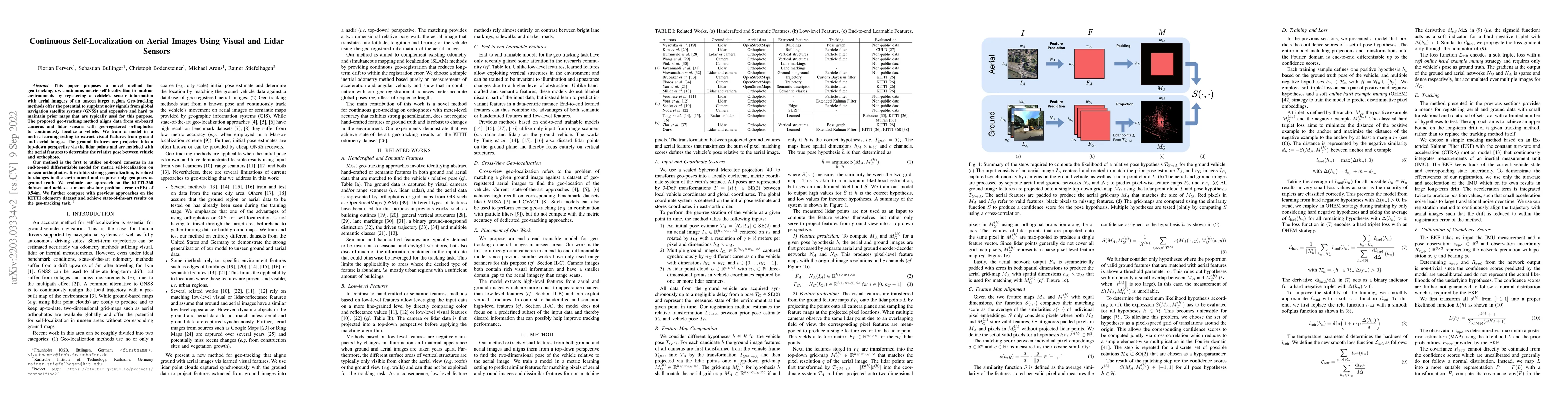
This paper proposes a novel method for geo-tracking, i.e. continuous metric self-localization in outdoor environments by registering a vehicle's sensor information with aerial imagery of an unseen target region. Geo-tracking methods offer the potential to supplant noisy signals from global navigation satellite systems (GNSS) and expensive and hard to maintain prior maps that are typically used for this purpose. The proposed geo-tracking method aligns data from on-board cameras and lidar sensors with geo-registered orthophotos to continuously localize a vehicle. We train a model in a metric learning setting to extract visual features from ground and aerial images. The ground features are projected into a top-down perspective via the lidar points and are matched with the aerial features to determine the relative pose between vehicle and orthophoto. Our method is the first to utilize on-board cameras in an end-to-end differentiable model for metric self-localization on unseen orthophotos. It exhibits strong generalization, is robust to changes in the environment and requires only geo-poses as ground truth. We evaluate our approach on the KITTI-360 dataset and achieve a mean absolute position error (APE) of 0.94m. We further compare with previous approaches on the KITTI odometry dataset and achieve state-of-the-art results on the geo-tracking task.
This graph shows how this paper is connected to other research. The current paper is shown in dark gray, papers that cite it are in green, and papers it references are in blue. You can:
• Hover over any node to see the paper title
• Click a node to view that paper's details
• Drag nodes to rearrange the graph
• Use the zoom controls (bottom right) to zoom in/out
Title | Authors | Year | Actions |
---|---|---|---|
RaSCL: Radar to Satellite Crossview Localization
|
Blerim Abdullai, Tony Wang, Xinyuan Qiao, Florian Shkurti, Tim D. Barfoot
|
2025
|
View Paper |
PIDLoc: Cross-View Pose Optimization Network Inspired by PID Controllers
|
Wooju Lee, Juhye Park, Dasol Hong, Chan-Yong Sung, Youngwoo Seo, Dongwan Kang, Hyun Myung
|
2025
|
View Paper |
LIVW-Localization: A Multimodal Information Fused Vehicle Localization Method for Complex, Large-Scale, and GNSS-Denied Environments
|
Jibo Wang, Zhaohui Shen, Zhengyang Lan, Chenglin Pang, Zheng Fang
|
2024
|
View Paper |
Increasing SLAM Pose Accuracy by Ground-to-Satellite Image Registration
|
Yanhao Zhang, Yujiao Shi, Shan Wang, Ankit Vora, Akhil Perincherry, Yongbo Chen, Hongdong Li
|
2024
|
View Paper |
AGL-Net: Aerial-Ground Cross-Modal Global Localization with Varying Scales
|
Tianrui Guan, Ruiqi Xian, Xijun Wang, Xiyang Wu, Mohamed Bashir Elnoor, Daeun Song, Dinesh Manocha
|
2024
|
View Paper |
C-BEV: Contrastive Bird's Eye View Training for Cross-View Image Retrieval and 3-DoF Pose Estimation
|
F. Fervers, Sebastian Bullinger, C. Bodensteiner, Michael Arens, Rainer Stiefelhagen
|
2023
|
View Paper |
Geo-Localization Based on Dynamically Weighted Factor-Graph
|
Miguel Ángel Muñoz-Bañón, Alejandro Olivas, Edison P. Velasco-Sánchez, F. Candelas, Fernando Torres
|
2023
|
View Paper |
View Consistent Purification for Accurate Cross-View Localization
|
Shan Wang, Yanhao Zhang, Akhil Perincherry, Ankit Vora, Hongdong Li
|
2023
|
View Paper |
Geo-Localization With Transformer-Based 2D-3D Match Network
|
Laijian Li, Yukai Ma, Kai Tang, Xiangrui Zhao, Chao Chen, Jianxin Huang, Jianbiao Mei, Yong Liu
|
2023
|
View Paper |
Real‐time mosaic of multiple fisheye surveillance videos based on geo‐registration and rectification
|
Jiongli Gao, Jun Wu, Mingyi Huang, Gang Xu
|
2023
|
View Paper |
Self-Supervised Lidar Place Recognition in Overhead Imagery Using Unpaired Data
|
T. Y. Tang, D. Martini
|
2023
|
View Paper |
Point-based metric and topological localisation between lidar and overhead imagery
|
T. Y. Tang, Daniele De Martini, Paul Newman
|
2023
|
View Paper |
Uncertainty-Aware Vision-Based Metric Cross-View Geolocalization
|
F. Fervers, Sebastian Bullinger, C. Bodensteiner, Michael Arens, R. Stiefelhagen
|
2022
|
View Paper |
Extraction and matching of 3D features for LiDAR-based self-localization in an urban environment
|
Marcus Hammer, Marcus Hebel, Michael Arens
|
2022
|
View Paper |
View-Invariant Localization using Semantic Objects in Changing Environments
|
Jacqueline Ankenbauer, Kaveh Fathian, J. How
|
2022
|
View Paper |
Satellite Image Based Cross-view Localization for Autonomous Vehicle
|
Shan Wang, Yanhao Zhang, Hongdong Li
|
2022
|
View Paper |
Autonomous Vehicle Localization Without Prior High-Definition Map
|
Sangmin Lee, Jee-Hwan Ryu
|
2024
|
View Paper |
Toward Precise Ambiguity-Aware Cross-Modality Global Self-Localization
|
Niklas Stannartz, Stefan Schütte, Markus Kuhn, Torsten Bertram
|
2023
|
View Paper |
Dynamically Weighted Factor-Graph for Feature-based Geo-localization
|
Miguel 'Angel Munoz-Ban'on, Alejandro Olivas, Edison P. Velasco-S'anchez, F. Candelas, Fernando Torres
|
2023
|
View Paper |
Matouš Vrba, Martin Saska, Václav Pritzl, Petr Štěpán
Published: 2023-07-03
Comments (0)