Authors
Publication
Metrics
Quick Actions
AI Quick Summary
This paper proposes an Iterative Homography Adjustment (IHA) scheme to enhance pose alignment in satellite-to-street-view image synthesis, and introduces a text-guided strategy for environmental control, significantly improving pose accuracy and realism while expanding environmental diversity.
Quick Answers
What methodology did the authors use?
The paper proposes a novel Iterative Homography Adjustment (IHA) scheme and a text-guided Zero-shot Environmental Control mechanism for satellite-to-street-view synthesis, addressing pose alignment and environmental diversity challenges. More in Methodology →
What are the key results?
The Iterative Homography Adjustment (IHA) scheme significantly improves pose accuracy and spatial consistency in generated street-view images. — The Text-guided Zero-shot Environmental Control enables fine-grained control over illumination and weather conditions, enhancing the realism and diversity of generated images. More in Key Results →
Why is this work significant?
This research is significant as it addresses the dual challenges of geometrical alignment and environmental diversity in satellite-to-street-view synthesis, which is crucial for autonomous driving and urban planning applications. More in Significance →
What are the main limitations?
The method might struggle with accurately restoring building details due to the significant discrepancy between satellite and ground views. — Lane marking generation shows inconsistencies with real-world lane markings, primarily due to misalignment of capture times between satellite maps and ground images. More in Limitations →
Abstract
Generating street-view images from satellite imagery is a challenging task, particularly in maintaining accurate pose alignment and incorporating diverse environmental conditions. While diffusion models have shown promise in generative tasks, their ability to maintain strict pose alignment throughout the diffusion process is limited. In this paper, we propose a novel Iterative Homography Adjustment (IHA) scheme applied during the denoising process, which effectively addresses pose misalignment and ensures spatial consistency in the generated street-view images. Additionally, currently, available datasets for satellite-to-street-view generation are limited in their diversity of illumination and weather conditions, thereby restricting the generalizability of the generated outputs. To mitigate this, we introduce a text-guided illumination and weather-controlled sampling strategy that enables fine-grained control over the environmental factors. Extensive quantitative and qualitative evaluations demonstrate that our approach significantly improves pose accuracy and enhances the diversity and realism of generated street-view images, setting a new benchmark for satellite-to-street-view generation tasks.
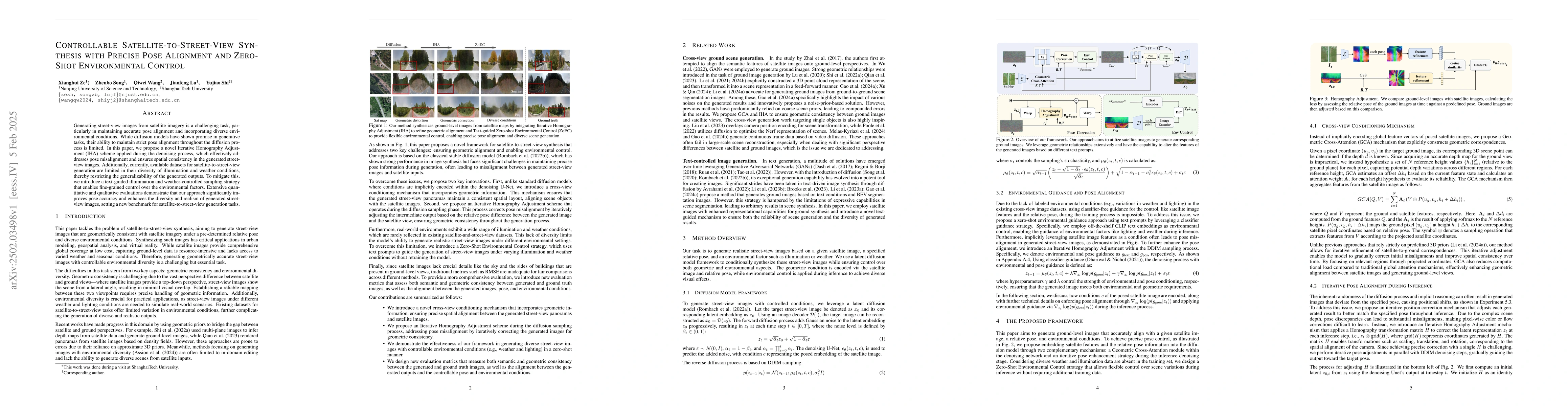
AI Key Findings
Generated Jun 11, 2025
Methodology — What approach did the authors take?
The paper proposes a novel Iterative Homography Adjustment (IHA) scheme and a text-guided Zero-shot Environmental Control mechanism for satellite-to-street-view synthesis, addressing pose alignment and environmental diversity challenges.
Key Results — What are the main findings?
- The Iterative Homography Adjustment (IHA) scheme significantly improves pose accuracy and spatial consistency in generated street-view images.
- The Text-guided Zero-shot Environmental Control enables fine-grained control over illumination and weather conditions, enhancing the realism and diversity of generated images.
- Extensive evaluations demonstrate that the proposed approach outperforms existing methods in both geometric accuracy and environmental adaptability.
- The method shows robustness in handling various initial noises and uncertainties during the diffusion process.
Significance — Why does this research matter?
This research is significant as it addresses the dual challenges of geometrical alignment and environmental diversity in satellite-to-street-view synthesis, which is crucial for autonomous driving and urban planning applications.
Technical Contribution — What is the technical contribution?
The paper introduces an Iterative Homography Adjustment (IHA) scheme and a Text-guided Zero-shot Environmental Control mechanism, both integrated into a diffusion model for improved satellite-to-street-view synthesis.
Novelty — What is new about this work?
The proposed method stands out by effectively addressing pose alignment and environmental control issues in satellite-to-street-view synthesis, setting a new benchmark for such tasks through extensive quantitative and qualitative evaluations.
Limitations — What are the limitations of this study?
- The method might struggle with accurately restoring building details due to the significant discrepancy between satellite and ground views.
- Lane marking generation shows inconsistencies with real-world lane markings, primarily due to misalignment of capture times between satellite maps and ground images.
Future Work — What did the authors propose for future work?
- Exploring methods to improve the accurate restoration of building details from satellite data.
- Investigating techniques to better align lane markings in generated images with real-world data.
How to Cite This Paper
@article{lu2025controllable,
title = {Controllable Satellite-to-Street-View Synthesis with Precise Pose
Alignment and Zero-Shot Environmental Control},
author = {Lu, Jianfeng and Wang, Qiwei and Ze, Xianghui and others},
year = {2025},
eprint = {2502.03498},
archivePrefix = {arXiv},
primaryClass = {eess.IV},
}
Lu, J., Wang, Q., Ze, X., Shi, Y., & Song, Z. (2025). Controllable Satellite-to-Street-View Synthesis with Precise Pose
Alignment and Zero-Shot Environmental Control. arXiv. https://arxiv.org/abs/2502.03498
Lu, Jianfeng, et al. "Controllable Satellite-to-Street-View Synthesis with Precise Pose
Alignment and Zero-Shot Environmental Control." arXiv, 2025, arxiv.org/abs/2502.03498.
PDF Preview
Citation Network
Current paper (gray), citations (green), references (blue)
Display is limited for performance on very large graphs.
Similar Papers
Found 4 papersDiffPortrait3D: Controllable Diffusion for Zero-Shot Portrait View Synthesis
Yuming Gu, You Xie, Hongyi Xu et al.
StreetCrafter: Street View Synthesis with Controllable Video Diffusion Models
Yunzhi Yan, Zhen Xu, Haotong Lin et al.
CrossViewDiff: A Cross-View Diffusion Model for Satellite-to-Street View Synthesis
Weijia Li, Jun He, Junyan Ye et al.
Coming Down to Earth: Satellite-to-Street View Synthesis for Geo-Localization
Maxim Maximov, Qunjie Zhou, Aysim Toker et al.
No citations found for this paper.
Comments (0)