Publication
Metrics
AI Quick Summary
This study evaluates the use of Google StreetView and Flickr images for predicting housing quality in Amsterdam, showing that Google StreetView provides more accurate scores than aerial images alone. By combining carefully filtered Flickr features with aerial images, the performance gap is reduced by half, suggesting viable alternatives to Google StreetView for liveability factor predictions.
Paper Preview
Abstract
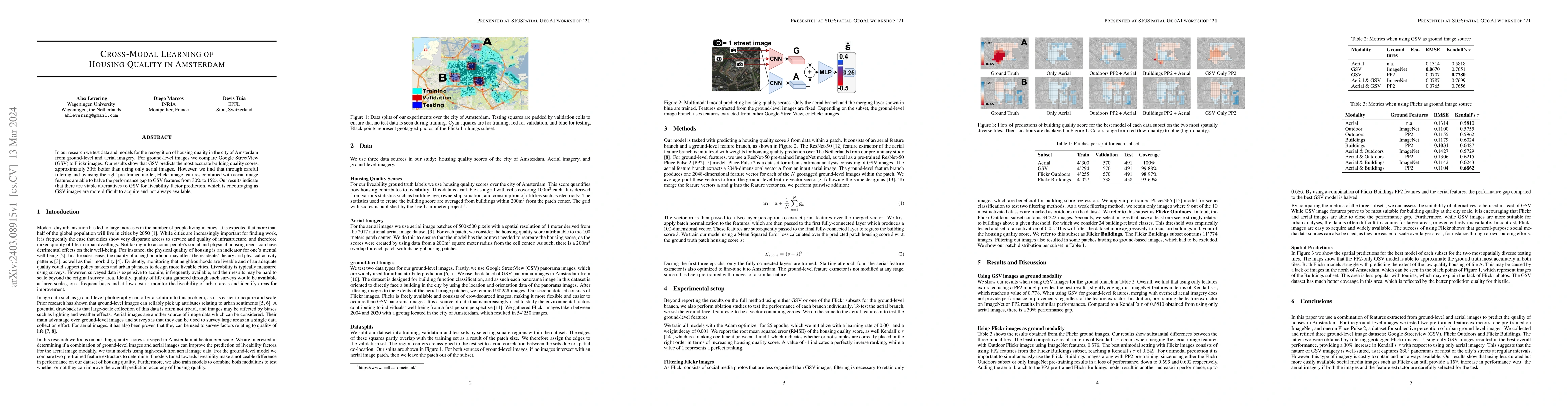
In our research we test data and models for the recognition of housing quality in the city of Amsterdam from ground-level and aerial imagery. For ground-level images we compare Google StreetView (GSV) to Flickr images. Our results show that GSV predicts the most accurate building quality scores, approximately 30% better than using only aerial images. However, we find that through careful filtering and by using the right pre-trained model, Flickr image features combined with aerial image features are able to halve the performance gap to GSV features from 30% to 15%. Our results indicate that there are viable alternatives to GSV for liveability factor prediction, which is encouraging as GSV images are more difficult to acquire and not always available.
AI Key Findings
Get AI-generated insights about this paper's methodology, results, significance, and more — seven facets brought into focus.
Impact
Paper Details
Authors
PDF Preview
Key Terms
Citation Network
Current paper (gray), citations (green), references (blue)
Display is limited for performance on very large graphs.
Discussion 0