ArxivLens

Publication

Published: Feb 21, 2026
Categories: cs.CV

Metrics

Source: ArXiv

Quick Answers

What methodology did the authors use?

We propose MM2D3D, a multi‑modal segmentation framework that uses camera images to guide 2D predictions via cross‑modal guided filtering and to supervise them with dynamic cross‑pseudo supervision, thereby densifying and improving intermediate 2D semantic maps before projecting back to 3D. More in Methodology →

What are the key results?

2D mIoU increased from 4.62% to 45.61% with MM2D3D — 3D mIoU increased from 74.72% to 77.53% More in Key Results →

Why is this work significant?

By converting sparse LiDAR projections into dense, accurate 2D predictions, the method substantially improves 3D segmentation accuracy, enabling more reliable perception for autonomous driving without heavy post‑processing. More in Significance →

What are the main limitations?

Requires synchronized camera images as auxiliary data — Struggles in sparse point regions such as traffic cones and distant pedestrians More in Limitations →

Paper Preview

Abstract

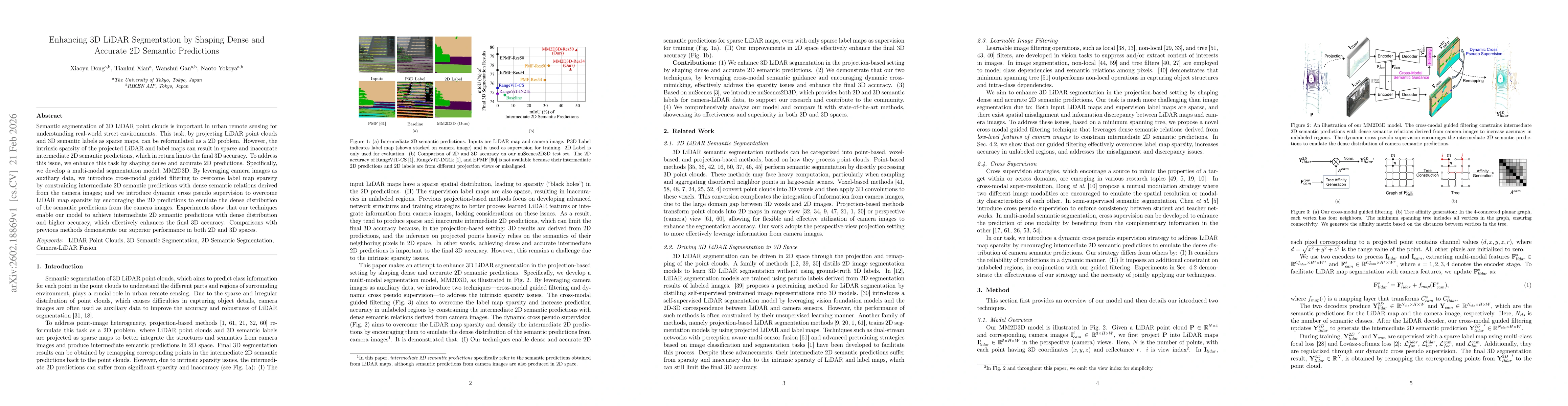
Semantic segmentation of 3D LiDAR point clouds is important in urban remote sensing for understanding real-world street environments. This task, by projecting LiDAR point clouds and 3D semantic labels as sparse maps, can be reformulated as a 2D problem. However, the intrinsic sparsity of the projected LiDAR and label maps can result in sparse and inaccurate intermediate 2D semantic predictions, which in return limits the final 3D accuracy. To address this issue, we enhance this task by shaping dense and accurate 2D predictions. Specifically, we develop a multi-modal segmentation model, MM2D3D. By leveraging camera images as auxiliary data, we introduce cross-modal guided filtering to overcome label map sparsity by constraining intermediate 2D semantic predictions with dense semantic relations derived from the camera images; and we introduce dynamic cross pseudo supervision to overcome LiDAR map sparsity by encouraging the 2D predictions to emulate the dense distribution of the semantic predictions from the camera images. Experiments show that our techniques enable our model to achieve intermediate 2D semantic predictions with dense distribution and higher accuracy, which effectively enhances the final 3D accuracy. Comparisons with previous methods demonstrate our superior performance in both 2D and 3D spaces.

Key Findings, in focus

Seven facets of this paper, analysed and brought into focus by AI.

AI-generated · verify against source Generated Feb 24, 2026
In focus · one-line synthesis

By converting sparse LiDAR projections into dense, accurate 2D predictions, the method substantially improves 3D segmentation accuracy, enabling more reliable perception for autonomous driving without heavy post‑processing.

01
MethodologyHow they did it

We propose MM2D3D, a multi‑modal segmentation framework that uses camera images to guide 2D predictions via cross‑modal guided filtering and to supervise them with dynamic cross‑pseudo supervision, thereby densifying and improving intermediate 2D semantic maps before projecting back to 3D.

02
ResultsWhat they found
  • 2D mIoU increased from 4.62% to 45.61% with MM2D3D
  • 3D mIoU increased from 74.72% to 77.53%
  • Outperforms prior projection‑based methods on nuScenes2D3D and nuScenes validation/test sets
03
SignificanceWhy it matters

By converting sparse LiDAR projections into dense, accurate 2D predictions, the method substantially improves 3D segmentation accuracy, enabling more reliable perception for autonomous driving without heavy post‑processing.

04
Technical ContributionsWhat's new technically

The joint use of cross‑modal guided filtering and dynamic cross‑pseudo supervision to densify 2D predictions, along with a dynamic weighting scheme that selects reliable pixels, constitutes the main technical advance.

05
NoveltyWhat sets it apart

This work is the first to shape dense 2D semantic predictions for LiDAR segmentation using cross‑modal guidance and dynamic pseudo supervision, achieving state‑of‑the‑art performance without post‑refinement.

06
LimitationsWhat to be cautious about
  • Requires synchronized camera images as auxiliary data
  • Struggles in sparse point regions such as traffic cones and distant pedestrians
07
Future WorkWhere it goes next
  • Explore unsupervised depth completion to reduce reliance on camera data
  • Investigate more robust alignment techniques to further mitigate misalignment between modalities

Paper Details

Paper ID: 2602.18869
Categories:
cs.CV

How to Cite This Paper

Reference manager: RIS EndNote


Discussion 0

This website uses cookies to ensure you get the best experience. Learn more