GAIR is a novel multimodal geo-foundation model architecture that integrates overhead remote sensing data with street view imagery and geolocation metadata to enhance geospatial task performance. It employs implicit neural representations to align street view images with remote sensing images, achieving superior results across diverse geospatial benchmarks.
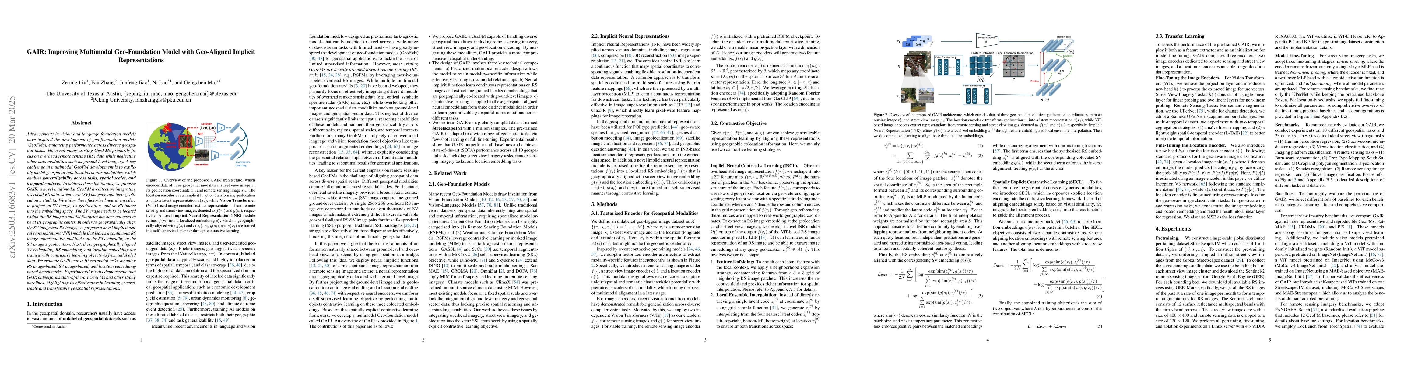
Advancements in vision and language foundation models have inspired the development of geo-foundation models (GeoFMs), enhancing performance across diverse geospatial tasks. However, many existing GeoFMs primarily focus on overhead remote sensing (RS) data while neglecting other data modalities such as ground-level imagery. A key challenge in multimodal GeoFM development is to explicitly model geospatial relationships across modalities, which enables generalizability across tasks, spatial scales, and temporal contexts. To address these limitations, we propose GAIR, a novel multimodal GeoFM architecture integrating overhead RS data, street view (SV) imagery, and their geolocation metadata. We utilize three factorized neural encoders to project an SV image, its geolocation, and an RS image into the embedding space. The SV image needs to be located within the RS image's spatial footprint but does not need to be at its geographic center. In order to geographically align the SV image and RS image, we propose a novel implicit neural representations (INR) module that learns a continuous RS image representation and looks up the RS embedding at the SV image's geolocation. Next, these geographically aligned SV embedding, RS embedding, and location embedding are trained with contrastive learning objectives from unlabeled data. We evaluate GAIR across 10 geospatial tasks spanning RS image-based, SV image-based, and location embedding-based benchmarks. Experimental results demonstrate that GAIR outperforms state-of-the-art GeoFMs and other strong baselines, highlighting its effectiveness in learning generalizable and transferable geospatial representations.
Generated Jun 10, 2025
The paper proposes GAIR, a multimodal geo-foundation model that integrates overhead remote sensing (RS) data, street view (SV) imagery, and their geolocation metadata. GAIR employs three factorized neural encoders to project SV images, their geolocations, and RS images into the embedding space, using an implicit neural representations (INR) module for geographical alignment.
This research is significant as it addresses the limitations of existing GeoFMs by focusing on multimodal data integration, improving generalizability across tasks, spatial scales, and temporal contexts, and demonstrating the effectiveness of geo-aligned implicit representations for geospatial tasks.
The paper introduces GAIR, a novel multimodal geo-foundation model architecture that integrates overhead RS data, street view imagery, and geolocation metadata using factorized neural encoders and an implicit neural representations (INR) module for geographical alignment.
GAIR's novelty lies in its approach to explicitly model cross-scale spatial relationships by leveraging implicit neural representations and spatially explicit contrastive learning, enabling the alignment of overhead and ground-level imagery while preserving geospatial proximity in learned embeddings.
Current paper (gray), citations (green), references (blue)
Display is limited for performance on very large graphs.
Yangxinyu Xie, Bowen Jiang, Xiaomeng Wang et al.
Xue Jiang, Yue Zhou, Junchi Yan et al.
Yifan Yang, Junzhou He, Yixian Zhang et al.
Title | Authors | Year | Actions |
---|
Comments (0)