GeomGS: LiDAR-Guided Geometry-Aware Gaussian Splatting for Robot Localization
Publication
Metrics
AI Quick Summary
GeomGS integrates LiDAR data into 3D Gaussian primitives via a probabilistic approach to enhance 3D map accuracy, introducing a Geometric Confidence Score for structural reliability. It achieves state-of-the-art localization and improved photometric performance in robotics and autonomous driving.
Paper Preview
Abstract
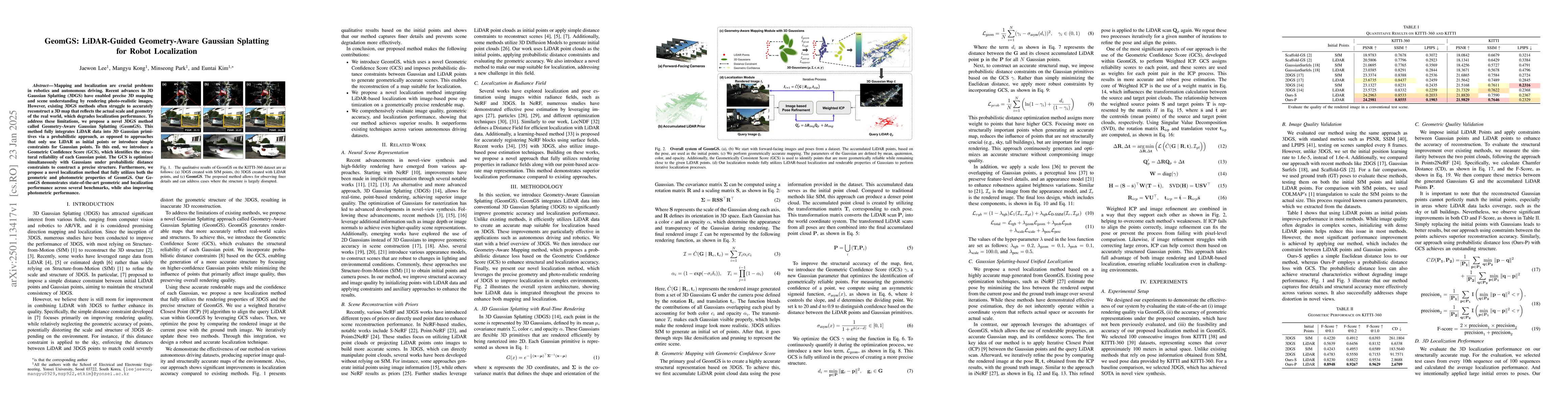
Mapping and localization are crucial problems in robotics and autonomous driving. Recent advances in 3D Gaussian Splatting (3DGS) have enabled precise 3D mapping and scene understanding by rendering photo-realistic images. However, existing 3DGS methods often struggle to accurately reconstruct a 3D map that reflects the actual scale and geometry of the real world, which degrades localization performance. To address these limitations, we propose a novel 3DGS method called Geometry-Aware Gaussian Splatting (GeomGS). This method fully integrates LiDAR data into 3D Gaussian primitives via a probabilistic approach, as opposed to approaches that only use LiDAR as initial points or introduce simple constraints for Gaussian points. To this end, we introduce a Geometric Confidence Score (GCS), which identifies the structural reliability of each Gaussian point. The GCS is optimized simultaneously with Gaussians under probabilistic distance constraints to construct a precise structure. Furthermore, we propose a novel localization method that fully utilizes both the geometric and photometric properties of GeomGS. Our GeomGS demonstrates state-of-the-art geometric and localization performance across several benchmarks, while also improving photometric performance.
AI Key Findings
Get AI-generated insights about this paper's methodology, results, significance, and more — seven facets brought into focus.
Paper Details
Authors
PDF Preview
Related Papers
No references found for this paper.
Discussion 0