Publication
Metrics
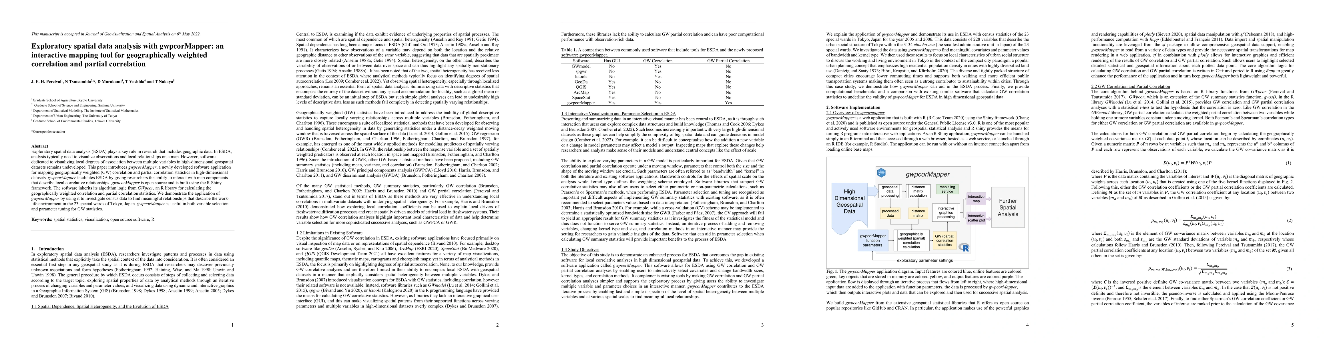
AI Quick Summary
gwpcorMapper is an interactive mapping tool developed for visualizing geographically weighted correlation and partial correlation in high-dimensional geospatial datasets. It facilitates exploratory spatial data analysis by allowing researchers to interact with maps that depict local relationships, demonstrating its utility in analyzing census data to uncover local variations in Tokyo's work-life environment.
Paper Preview
Abstract
Exploratory spatial data analysis (ESDA) plays a key role in research that includes geographic data. In ESDA, analysts often want to be able to visualize observations and local relationships on a map. However, software dedicated to visualizing local spatial relations be-tween multiple variables in high dimensional datasets remains undeveloped. This paper introduces gwpcorMapper, a newly developed software application for mapping geographically weighted correlation and partial correlation in large multivariate datasets. gwpcorMap-per facilitates ESDA by giving researchers the ability to interact with map components that describe local correlative relationships. We built gwpcorMapper using the R Shiny framework. The software inherits its core algorithm from GWpcor, an R library for calculating the geographically weighted correlation and partial correlation statistics. We demonstrate the application of gwpcorMapper by using it to explore census data in order to find meaningful relationships that describe the work-life environment in the 23 special wards of Tokyo, Japan. We show that gwpcorMapper is useful in both variable selection and parameter tuning for geographically weighted statistics. gwpcorMapper highlights that there are strong statistically clear local variations in the relationship between the number of commuters and the total number of hours worked when considering the total population in each district across the 23 special wards of Tokyo. Our application demonstrates that the ESDA process with high-dimensional geospatial data using gwpcorMapper has applications across multiple fields.
AI Key Findings
Get AI-generated insights about this paper's methodology, results, significance, and more — seven facets brought into focus.
Impact
Paper Details
Authors
PDF Preview
Key Terms
Citation Network
Current paper (gray), citations (green), references (blue)
Display is limited for performance on very large graphs.
Discussion 0