Joint Modelling of Line and Point Data on Metric Graphs

Source: ArXiv

AI Quick Summary

This paper presents a joint modelling approach for line and point data on metric graphs, showing that it leads to strong improvements in estimating parameters and predicting unobserved locations compared to a simplified method.

Share: Share on X LinkedIn

Summary

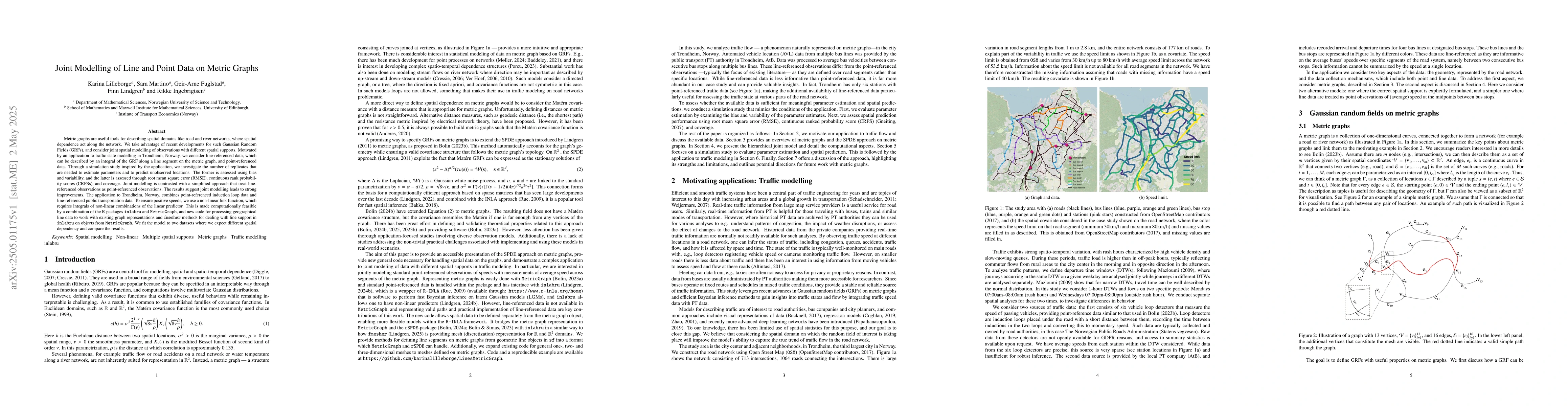
Metric graphs are useful tools for describing spatial domains like road and river networks, where spatial dependence act along the network. We take advantage of recent developments for such Gaussian Random Fields (GRFs), and consider joint spatial modelling of observations with different spatial supports. Motivated by an application to traffic state modelling in Trondheim, Norway, we consider line-referenced data, which can be described by an integral of the GRF along a line segment on the metric graph, and point-referenced data. Through a simulation study inspired by the application, we investigate the number of replicates that are needed to estimate parameters and to predict unobserved locations. The former is assessed using bias and variability, and the latter is assessed through root mean square error (RMSE), continuous rank probability scores (CRPSs), and coverage. Joint modelling is contrasted with a simplified approach that treat line-referenced observations as point-referenced observations. The results suggest joint modelling leads to strong improvements. The application to Trondheim, Norway, combines point-referenced induction loop data and line-referenced public transportation data. To ensure positive speeds, we use a non-linear link function, which requires integrals of non-linear combinations of the linear predictor. This is made computationally feasible by a combination of the R packages inlabru and MetricGraph, and new code for processing geographical line data to work with existing graph representations and fmesher methods for dealing with line support in inlabru on objects from MetricGraph. We fit the model to two datasets where we expect different spatial dependency and compare the results.

AI Key Findings

Generated May 28, 2025

Methodology

The research employs a joint modelling approach for line and point data on metric graphs, utilizing Gaussian Random Fields (GRFs) to describe spatial domains such as road and river networks. It investigates the number of replicates needed for accurate parameter estimation and prediction, contrasting joint modelling with a simplified approach treating line-referenced observations as point-referenced observations.

Key Results

  • Joint modelling leads to significant improvements over simplified approaches in both parameter estimation and prediction.
  • A simulation study suggests that using more than one replicate enhances the accuracy of estimations.
  • The application to Trondheim, Norway, successfully combines point-referenced and line-referenced data for traffic state modelling, demonstrating the practical utility of the method.

Significance

This research is significant as it provides a robust method for modelling spatial data with different supports, which is crucial for applications like traffic state modelling where both line (e.g., road segments) and point (e.g., traffic sensors) data are prevalent.

Technical Contribution

The paper extends the functionality of R packages to handle line-referenced data on metric graphs, facilitating joint modelling of line and point data through Gaussian Random Fields, which is a novel approach in spatial statistics.

Novelty

The novelty of this work lies in its comprehensive approach to joint modelling of line and point data on metric graphs, contrasting it with simpler point-referenced models and demonstrating its effectiveness through both simulation studies and a real-world application.

Limitations

  • The study is limited by the computational complexity of handling line-referenced data, which requires extensions to existing R packages like inlabru and MetricGraph.
  • The method's performance may depend on the quality and representativeness of the input data.

Future Work

  • Further research could explore the application of this method to other spatial domains with mixed line and point data, such as river networks or urban infrastructure.
  • Investigating the scalability of the method for very large datasets would be beneficial.

Paper Details

PDF Preview

Download PDF

Citation Network

Current paper (gray), citations (green), references (blue)

Display is limited for performance on very large graphs.

Current Paper
Citations
References
Click to view

No citations found for this paper.

Comments (0)

This website uses cookies to ensure you get the best experience. Learn more