Publication
Metrics
AI Quick Summary
This paper presents LIGHT, a unified multitask learning network for simultaneous individual building extraction and height estimation from satellite images. The proposed Gated Cross Task Interaction (GCTI) module enhances feature interaction between the instance segmentation and height estimation branches, achieving superior performance on the DFC2023 dataset.
Paper Preview
Abstract
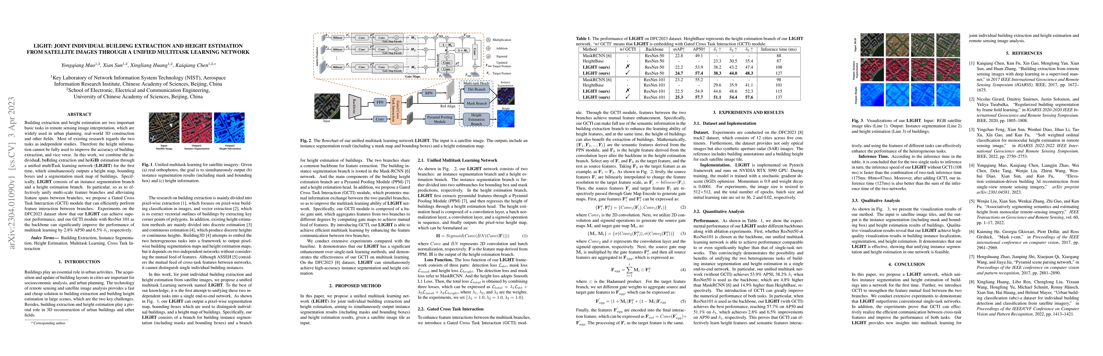
Building extraction and height estimation are two important basic tasks in remote sensing image interpretation, which are widely used in urban planning, real-world 3D construction, and other fields. Most of the existing research regards the two tasks as independent studies. Therefore the height information cannot be fully used to improve the accuracy of building extraction and vice versa. In this work, we combine the individuaL buIlding extraction and heiGHt estimation through a unified multiTask learning network (LIGHT) for the first time, which simultaneously outputs a height map, bounding boxes, and a segmentation mask map of buildings. Specifically, LIGHT consists of an instance segmentation branch and a height estimation branch. In particular, so as to effectively unify multi-scale feature branches and alleviate feature spans between branches, we propose a Gated Cross Task Interaction (GCTI) module that can efficiently perform feature interaction between branches. Experiments on the DFC2023 dataset show that our LIGHT can achieve superior performance, and our GCTI module with ResNet101 as the backbone can significantly improve the performance of multitask learning by 2.8% AP50 and 6.5% delta1, respectively.
AI Key Findings
Get AI-generated insights about this paper's methodology, results, significance, and more — seven facets brought into focus.
Impact
Paper Details
Authors
PDF Preview
Key Terms
Citation Network
Current paper (gray), citations (green), references (blue)
Display is limited for performance on very large graphs.
Discussion 0