MetaSegNet: Metadata-collaborative Vision-Language Representation Learning for Semantic Segmentation of Remote Sensing Images
Publication
Metrics
AI Quick Summary
MetaSegNet introduces a novel multimodal approach for semantic segmentation of remote sensing images by leveraging both visual data and metadata-derived text prompts. This method combines vision and language features to enhance reliability and generalization, achieving top performance on several datasets.
Paper Preview
Abstract
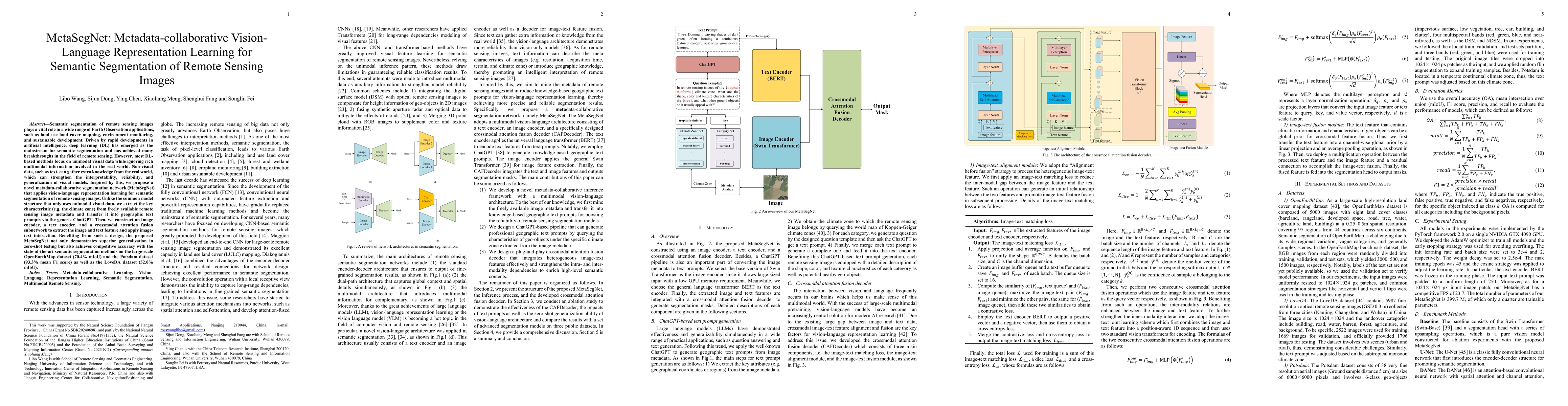
Semantic segmentation of remote sensing images plays a vital role in a wide range of Earth Observation (EO) applications, such as land use land cover mapping, environment monitoring, and sustainable development. Driven by rapid developments in Artificial Intelligence (AI), deep learning (DL) has emerged as the mainstream tool for semantic segmentation and has achieved many breakthroughs in the field of remote sensing. However, the existing DL-based methods mainly focus on unimodal visual data while ignoring the rich multimodal information involved in the real world, usually demonstrating weak reliability and generlization. Inspired by the success of Vision Transformers and large language models, we propose a novel metadata-collaborative multimodal segmentation network (MetaSegNet) that applies vision-language representation learning for semantic segmentation of remote sensing images. Unlike the common model structure that only uses unimodal visual data, we extract the key characteristic (e.g. the climate zone) from freely available remote sensing image metadata and transfer it into knowledge-based text prompts via the generic ChatGPT. Then, we construct an image encoder, a text encoder and a cross-modal attention fusion subnetwork to extract the image and text feature and apply image-text interaction. Benefiting from such a design, the proposed MetaSegNet demonstrates superior generalization and achieves competitive accuracy with the state-of-the-art semantic segmentation methods on the large-scale OpenEarthMap dataset (68.6% mIoU) and Potsdam dataset (93.3% mean F1 score) as well as LoveDA dataset (52.2% mIoU).
AI Key Findings
Get AI-generated insights about this paper's methodology, results, significance, and more — seven facets brought into focus.
Impact
Paper Details
Authors
PDF Preview
Key Terms
Citation Network
Current paper (gray), citations (green), references (blue)
Display is limited for performance on very large graphs.
Discussion 0