Authors
Publication
Metrics
Quick Actions
AI Quick Summary
A new navigation approach, LanBLoc-BMM, improves localization accuracy in GPS-denied environments by combining landmark-based localization with a battlefield-specific motion model and Extended Kalman Filter. It outperforms state-of-the-art visual localization algorithms on real-world datasets.
Quick Answers
What is "SafeNav: Safe Path Navigation using Landmark Based Localization in a GPS-denied Environment" about?
A new navigation approach, LanBLoc-BMM, improves localization accuracy in GPS-denied environments by combining landmark-based localization with a battlefield-specific motion model and Extended Kalman Filter. It outperforms state-of-the-art visual localization algorithms on real-world datasets.
What methodology did the authors use?
The research proposes LanBLoc-BMM, a navigation approach combining landmark-based localization (LanBLoc) with a battlefield-specific motion model (BMM) and Extended Kalman Filter (EKF). It benchmarks against three state-of-the-art visual localization algorithms, evaluating performance using metrics like ADE, FDE, and a new Average Weighted Risk Score (AWRS). More in Methodology →
What are the key results?
LanBLoc-BMM (with EKF) outperforms compared algorithms in ADE, FDE, and AWRS on real-imitated datasets. — Two safe navigation methods, SafeNav-CHull and SafeNav-Centroid, are introduced, integrating LanBLoc-BMM(EKF) with Risk-Aware RRT* for obstacle avoidance. More in Key Results →
Why is this work significant?
This research is significant as it addresses the vulnerability of GPS reliance in battlefield environments, ensuring safe and efficient maneuvering of military forces in contested and hazardous areas by providing an alternative localization and navigation method. More in Significance →
What are the main limitations?
The method's performance relies on the quality and availability of landmarks in the environment. — Computational demands could be a limiting factor for real-time applications on less powerful hardware. More in Limitations →
Abstract
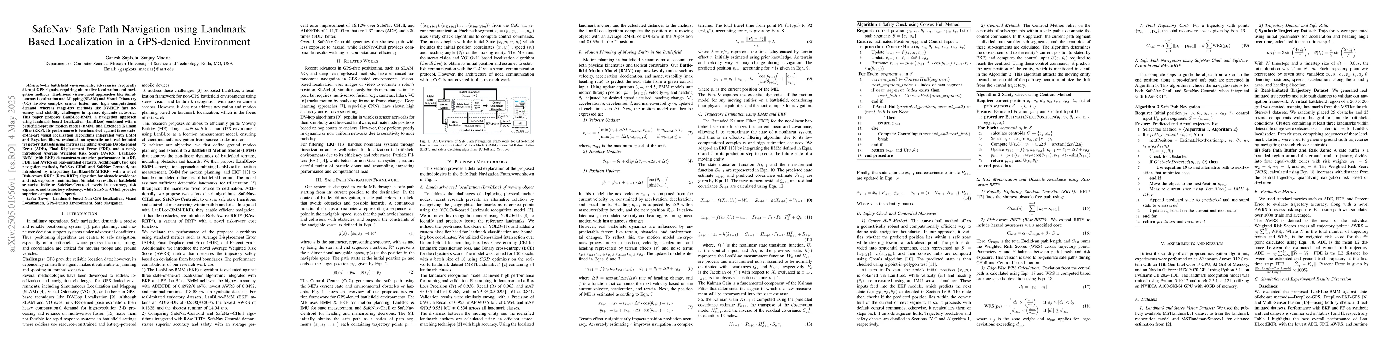
In battlefield environments, adversaries frequently disrupt GPS signals, requiring alternative localization and navigation methods. Traditional vision-based approaches like Simultaneous Localization and Mapping (SLAM) and Visual Odometry (VO) involve complex sensor fusion and high computational demand, whereas range-free methods like DV-HOP face accuracy and stability challenges in sparse, dynamic networks. This paper proposes LanBLoc-BMM, a navigation approach using landmark-based localization (LanBLoc) combined with a battlefield-specific motion model (BMM) and Extended Kalman Filter (EKF). Its performance is benchmarked against three state-of-the-art visual localization algorithms integrated with BMM and Bayesian filters, evaluated on synthetic and real-imitated trajectory datasets using metrics including Average Displacement Error (ADE), Final Displacement Error (FDE), and a newly introduced Average Weighted Risk Score (AWRS). LanBLoc-BMM (with EKF) demonstrates superior performance in ADE, FDE, and AWRS on real-imitated datasets. Additionally, two safe navigation methods, SafeNav-CHull and SafeNav-Centroid, are introduced by integrating LanBLoc-BMM(EKF) with a novel Risk-Aware RRT* (RAw-RRT*) algorithm for obstacle avoidance and risk exposure minimization. Simulation results in battlefield scenarios indicate SafeNav-Centroid excels in accuracy, risk exposure, and trajectory efficiency, while SafeNav-CHull provides superior computational speed.
AI Key Findings
Generated May 28, 2025
Methodology — What approach did the authors take?
The research proposes LanBLoc-BMM, a navigation approach combining landmark-based localization (LanBLoc) with a battlefield-specific motion model (BMM) and Extended Kalman Filter (EKF). It benchmarks against three state-of-the-art visual localization algorithms, evaluating performance using metrics like ADE, FDE, and a new Average Weighted Risk Score (AWRS).
Key Results — What are the main findings?
- LanBLoc-BMM (with EKF) outperforms compared algorithms in ADE, FDE, and AWRS on real-imitated datasets.
- Two safe navigation methods, SafeNav-CHull and SafeNav-Centroid, are introduced, integrating LanBLoc-BMM(EKF) with Risk-Aware RRT* for obstacle avoidance.
- Simulation results indicate SafeNav-Centroid excels in accuracy, risk exposure, and trajectory efficiency, while SafeNav-CHull provides superior computational speed.
Significance — Why does this research matter?
This research is significant as it addresses the vulnerability of GPS reliance in battlefield environments, ensuring safe and efficient maneuvering of military forces in contested and hazardous areas by providing an alternative localization and navigation method.
Technical Contribution — What is the technical contribution?
The main technical contribution is the development of LanBLoc-BMM, a novel navigation approach that combines landmark-based localization with a battlefield-specific motion model and EKF, providing robust localization and trajectory estimation in GPS-denied environments.
Novelty — What is new about this work?
This work introduces a novel combination of landmark-based localization, battlefield-specific motion modeling, and EKF for robust navigation in GPS-denied environments, outperforming existing methods in terms of accuracy, risk exposure, and computational efficiency.
Limitations — What are the limitations of this study?
- The method's performance relies on the quality and availability of landmarks in the environment.
- Computational demands could be a limiting factor for real-time applications on less powerful hardware.
Future Work — What did the authors propose for future work?
- Reducing computational demands to enhance real-time applicability.
- Improving adaptability to dynamic obstacles and hazard scenarios.
- Exploring alternative localization strategies for environments lacking identifiable landmarks.
How to Cite This Paper
@article{sapkota2025safenav,
title = {SafeNav: Safe Path Navigation using Landmark Based Localization in a
GPS-denied Environment},
author = {Sapkota, Ganesh and Madria, Sanjay},
year = {2025},
eprint = {2505.01956},
archivePrefix = {arXiv},
primaryClass = {cs.RO},
}
Sapkota, G., & Madria, S. (2025). SafeNav: Safe Path Navigation using Landmark Based Localization in a
GPS-denied Environment. arXiv. https://arxiv.org/abs/2505.01956
Sapkota, Ganesh, and Sanjay Madria. "SafeNav: Safe Path Navigation using Landmark Based Localization in a
GPS-denied Environment." arXiv, 2025, arxiv.org/abs/2505.01956.
PDF Preview
Citation Network
Current paper (gray), citations (green), references (blue)
Display is limited for performance on very large graphs.
Similar Papers
Found 4 papersSecure Navigation using Landmark-based Localization in a GPS-denied Environment
Ganesh Sapkota, Sanjay Madria
Landmark-based Localization using Stereo Vision and Deep Learning in GPS-Denied Battlefield Environment
Ganesh Sapkota, Sanjay Madria
Landmark-based Distributed Topological Mapping and Navigation in GPS-denied Urban Environments Using Teams of Low-cost Robots
Mohammad Saleh Teymouri, Subhrajit Bhattacharya
No citations found for this paper.
Comments (0)