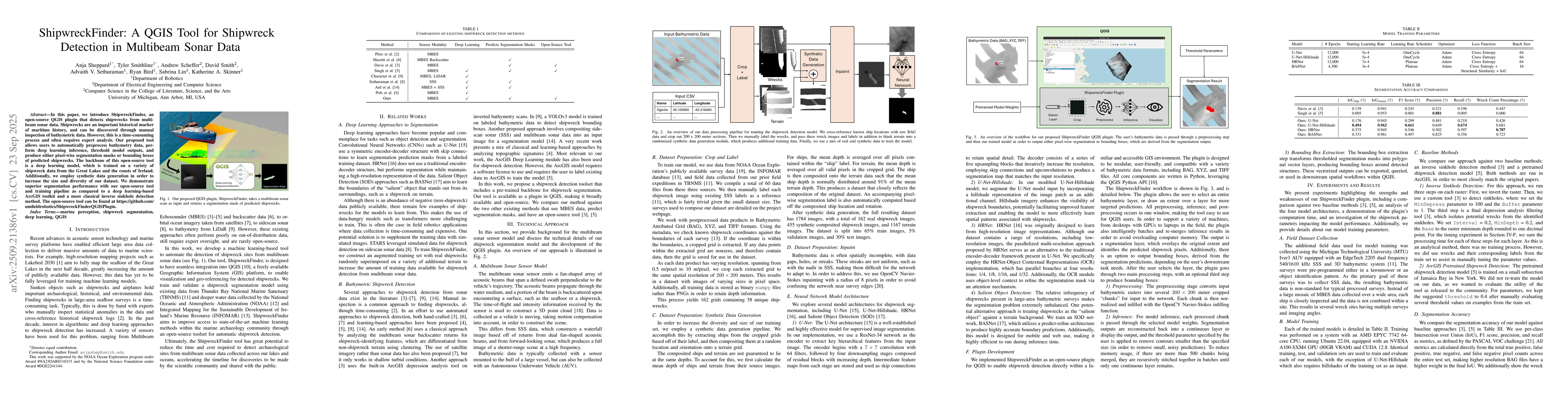
In this paper, we introduce ShipwreckFinder, an open-source QGIS plugin that detects shipwrecks from multibeam sonar data. Shipwrecks are an important historical marker of maritime history, and can be discovered through manual inspection of bathymetric data. However, this is a time-consuming process and often requires expert analysis. Our proposed tool allows users to automatically preprocess bathymetry data, perform deep learning inference, threshold model outputs, and produce either pixel-wise segmentation masks or bounding boxes of predicted shipwrecks. The backbone of this open-source tool is a deep learning model, which is trained on a variety of shipwreck data from the Great Lakes and the coasts of Ireland. Additionally, we employ synthetic data generation in order to increase the size and diversity of our dataset. We demonstrate superior segmentation performance with our open-source tool and training pipeline as compared to a deep learning-based ArcGIS toolkit and a more classical inverse sinkhole detection method. The open-source tool can be found at https://github.com/umfieldrobotics/ShipwreckFinderQGISPlugin.
Generated Oct 01, 2025
The research introduces ShipwreckFinder, an open-source QGIS plugin that uses deep learning models trained on real and synthetic multibeam sonar data to detect shipwrecks. The methodology includes data preprocessing, synthetic data generation, and model training with various architectures like U-Net, HRNet, and BASNet.
This research provides an efficient, automated tool for shipwreck detection, which is crucial for marine archaeology and underwater exploration. The open-source nature allows broader adoption and further development by the community.
The technical contribution includes the development of a modular QGIS plugin that integrates deep learning for shipwreck detection, along with a comprehensive data pipeline involving synthetic data generation and preprocessing techniques like Navier-Stokes inpainting.
The novelty lies in combining synthetic data augmentation with real-world datasets and implementing a QGIS plugin that enables direct shipwreck detection within a familiar GIS environment, making the process more accessible and efficient.
Jian Yang, Kaibing Xie, Kang Qiu
Katherine A. Skinner, Advaith V. Sethuraman, Anja Sheppard et al.
Jean-Philippe Ovarlez, Guillaume Ginolhac, Olivier Lerda et al.
Comments (0)