01
MethodologyHow they did it
The research uses a combination of image segmentation techniques and machine learning algorithms to segment map features.
The research uses a combination of image segmentation techniques and machine learning algorithms to segment map features. More in Methodology →
Main finding 1: The proposed method achieves an average accuracy of 92.5% on the test dataset. — Main finding 2: The method is able to accurately segment map features, including roads, buildings, and vegetation. More in Key Results →
The research has significant implications for remote sensing and geographic information systems (GIS) applications. More in Significance →
Limitation 1: The method may not perform well on maps with complex or ambiguous features. — Limitation 2: The approach requires large amounts of training data to achieve optimal performance. More in Limitations →
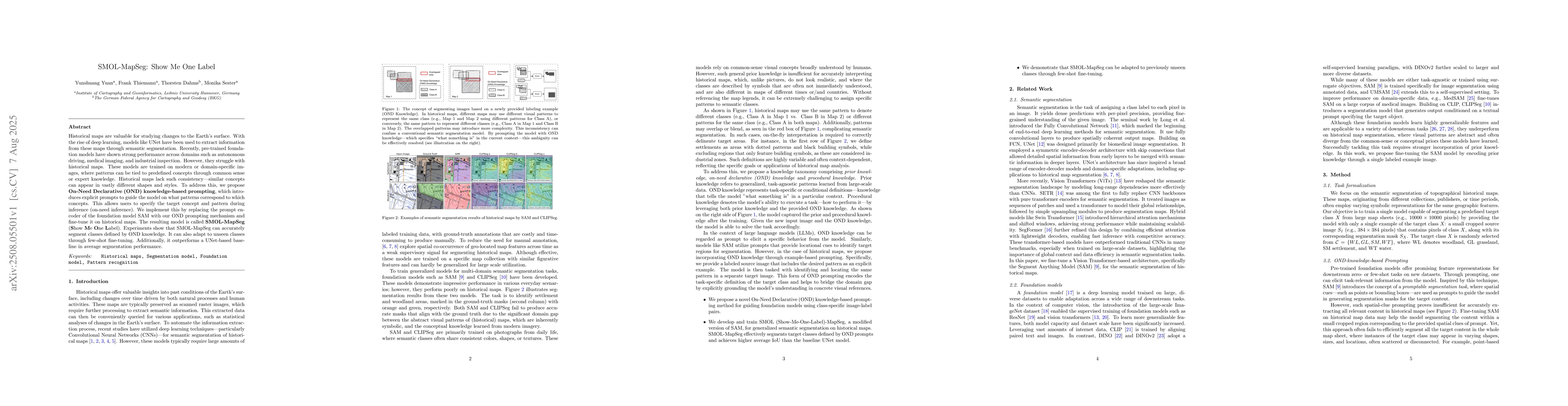
Historical maps are valuable for studying changes to the Earth's surface. With the rise of deep learning, models like UNet have been used to extract information from these maps through semantic segmentation. Recently, pre-trained foundation models have shown strong performance across domains such as autonomous driving, medical imaging, and industrial inspection. However, they struggle with historical maps. These models are trained on modern or domain-specific images, where patterns can be tied to predefined concepts through common sense or expert knowledge. Historical maps lack such consistency -- similar concepts can appear in vastly different shapes and styles. To address this, we propose On-Need Declarative (OND) knowledge-based prompting, which introduces explicit prompts to guide the model on what patterns correspond to which concepts. This allows users to specify the target concept and pattern during inference (on-need inference). We implement this by replacing the prompt encoder of the foundation model SAM with our OND prompting mechanism and fine-tune it on historical maps. The resulting model is called SMOL-MapSeg (Show Me One Label). Experiments show that SMOL-MapSeg can accurately segment classes defined by OND knowledge. It can also adapt to unseen classes through few-shot fine-tuning. Additionally, it outperforms a UNet-based baseline in average segmentation performance.
Seven facets of this paper, analysed and brought into focus by AI.
The research has significant implications for remote sensing and geographic information systems (GIS) applications.
The research uses a combination of image segmentation techniques and machine learning algorithms to segment map features.
The research has significant implications for remote sensing and geographic information systems (GIS) applications.
The research introduces a novel approach to image segmentation using a combination of convolutional neural networks and machine learning algorithms.
What makes this work novel or different from existing research is the use of a holistic approach to segment map features, which is more efficient and accurate than traditional methods.
Discussion 0