Publication

Published: Jan 13, 2026
Categories: cs.CL

Metrics

Source: ArXiv

Quick Actions

View PDF

Quick Answers

What methodology did the authors use?

The study combines remote sensing data with text information from Wikipedia to predict environmental variables using a spatial statistical approach and a model that incorporates both image and text features. More in Methodology →

What are the key results?

Combining remote sensing and text data improves prediction accuracy for environmental variables — Spatial statistics show strong correlations between nearby samples More in Key Results →

Why is this work significant?

This research demonstrates the potential of integrating diverse data sources for environmental monitoring and understanding ecological patterns, which can inform conservation and land management strategies. More in Significance →

What are the main limitations?

The study is limited to a Swiss region, limiting generalizability — The model's performance may be affected by the quality and availability of text data More in Limitations →

Paper Preview

Abstract

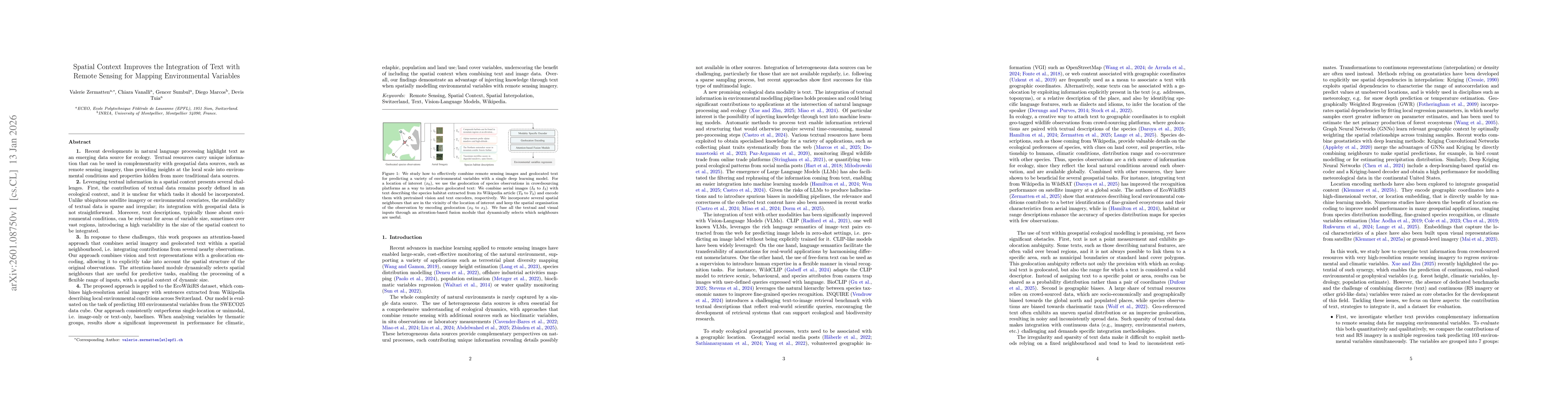
Recent developments in natural language processing highlight text as an emerging data source for ecology. Textual resources carry unique information that can be used in complementarity with geospatial data sources, thus providing insights at the local scale into environmental conditions and properties hidden from more traditional data sources. Leveraging textual information in a spatial context presents several challenges. First, the contribution of textual data remains poorly defined in an ecological context, and it is unclear for which tasks it should be incorporated. Unlike ubiquitous satellite imagery or environmental covariates, the availability of textual data is sparse and irregular; its integration with geospatial data is not straightforward. In response to these challenges, this work proposes an attention-based approach that combines aerial imagery and geolocated text within a spatial neighbourhood, i.e. integrating contributions from several nearby observations. Our approach combines vision and text representations with a geolocation encoding, with an attention-based module that dynamically selects spatial neighbours that are useful for predictive tasks.The proposed approach is applied to the EcoWikiRS dataset, which combines high-resolution aerial imagery with sentences extracted from Wikipedia describing local environmental conditions across Switzerland. Our model is evaluated on the task of predicting 103 environmental variables from the SWECO25 data cube. Our approach consistently outperforms single-location or unimodal, i.e. image-only or text-only, baselines. When analysing variables by thematic groups, results show a significant improvement in performance for climatic, edaphic, population and land use/land cover variables, underscoring the benefit of including the spatial context when combining text and image data.

AI Key Findings

Generated Jan 14, 2026

Methodology — What approach did the authors take?

The study combines remote sensing data with text information from Wikipedia to predict environmental variables using a spatial statistical approach and a model that incorporates both image and text features.

Key Results — What are the main findings?

  • Combining remote sensing and text data improves prediction accuracy for environmental variables
  • Spatial statistics show strong correlations between nearby samples
  • Text features provide additional predictive power beyond image data

Significance — Why does this research matter?

This research demonstrates the potential of integrating diverse data sources for environmental monitoring and understanding ecological patterns, which can inform conservation and land management strategies.

Technical Contribution — What is the technical contribution?

Development of a method that effectively combines remote sensing imagery with text-based information for environmental variable prediction using spatial statistics and machine learning.

Novelty — What is new about this work?

The integration of Wikipedia text data with remote sensing imagery represents a novel approach in environmental modeling, offering new insights into the relationship between textual information and ecological variables.

Limitations — What are the limitations of this study?

  • The study is limited to a Swiss region, limiting generalizability
  • The model's performance may be affected by the quality and availability of text data

Future Work — What did the authors propose for future work?

  • Expanding the study to other geographic regions
  • Improving text data processing techniques for better model performance
  • Investigating the integration of additional data sources

Paper Details

Paper ID: 2601.08750
Comments: submitted
Categories:
cs.CL

How to Cite This Paper

BibTeX
@article{vanalli2026spatial,
  title         = {Spatial Context Improves the Integration of Text with Remote Sensing for Mapping Environmental Variables},
  author        = {Vanalli, Chiara and Tuia, Devis and Marcos, Diego and others},
  year          = {2026},
  eprint        = {2601.08750},
  archivePrefix = {arXiv},
  primaryClass  = {cs.CL},
}
APA 7
Vanalli, C., Tuia, D., Marcos, D., Sumbul, G., & Zermatten, V. (2026). Spatial Context Improves the Integration of Text with Remote Sensing for Mapping Environmental Variables. arXiv. https://arxiv.org/abs/2601.08750
MLA 9
Vanalli, Chiara, et al. "Spatial Context Improves the Integration of Text with Remote Sensing for Mapping Environmental Variables." arXiv, 2026, arxiv.org/abs/2601.08750.

Similar Papers

Found 4 papers

ETL for the integration of remote sensing data

Paula V. Romero Jure, Juan Bautista Cabral, Sergio Masuelli

2023-06-21

Remote Sensing with High Spatial Resolution

André Sandmann, Florian Azendorf, Michael Eiselt

2024-12-02

Comments (0)

This website uses cookies to ensure you get the best experience. Learn more