ArxivLens

Publication

Published: Sep 17, 2025
Categories: cs.LG, cs.CL

Metrics

Source: ArXiv

Quick Answers

What methodology did the authors use?

The research employed a combination of natural language processing and geospatial analysis to evaluate large language models' ability to reverse navigation routes. It involved generating detailed route instructions, assessing model outputs through similarity checks, and analyzing confidence levels in generated directions. More in Methodology →

What are the key results?

LLMs demonstrate strong grasp of popular landmarks but struggle with less common locations and geospatial transformations — Lower temperature settings improved consistency in route reversal tasks, though randomness persisted even at 0.0 temperature More in Key Results →

Why is this work significant?

This research provides critical insights into the capabilities and limitations of LLMs in geospatial navigation tasks, which has implications for improving route planning systems and understanding AI's role in spatial cognition. More in Significance →

What are the main limitations?

Information loss occurs during translation between natural language and geometric representations — High density road networks and roundabouts pose significant challenges for accurate route reversal More in Limitations →

Paper Preview

Abstract

Humans can interpret geospatial information through natural language, while the geospatial cognition capabilities of Large Language Models (LLMs) remain underexplored. Prior research in this domain has been constrained by non-quantifiable metrics, limited evaluation datasets and unclear research hierarchies. Therefore, we propose a large-scale benchmark and conduct a comprehensive evaluation of the geospatial route cognition of LLMs. We create a large-scale evaluation dataset comprised of 36000 routes from 12 metropolises worldwide. Then, we introduce PathBuilder, a novel tool for converting natural language instructions into navigation routes, and vice versa, bridging the gap between geospatial information and natural language. Finally, we propose a new evaluation framework and metrics to rigorously assess 11 state-of-the-art (SOTA) LLMs on the task of route reversal. The benchmark reveals that LLMs exhibit limitation to reverse routes: most reverse routes neither return to the starting point nor are similar to the optimal route. Additionally, LLMs face challenges such as low robustness in route generation and high confidence for their incorrect answers. Code\ \&\ Data available here: \href{https://github.com/bghjmn32/EMNLP2025_Turnback}{TurnBack.}
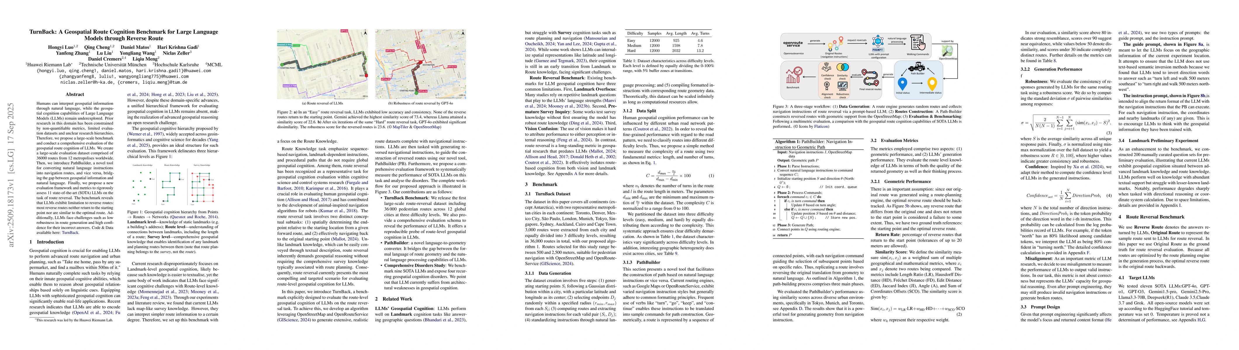
Key Findings, in focus

Seven facets of this paper, analysed and brought into focus by AI.

AI-generated · verify against source Generated Sep 30, 2025
In focus · one-line synthesis

This research provides critical insights into the capabilities and limitations of LLMs in geospatial navigation tasks, which has implications for improving route planning systems and understanding AI's role in spatial cognition.

01
MethodologyHow they did it

The research employed a combination of natural language processing and geospatial analysis to evaluate large language models' ability to reverse navigation routes. It involved generating detailed route instructions, assessing model outputs through similarity checks, and analyzing confidence levels in generated directions.

02
ResultsWhat they found
  • LLMs demonstrate strong grasp of popular landmarks but struggle with less common locations and geospatial transformations
  • Lower temperature settings improved consistency in route reversal tasks, though randomness persisted even at 0.0 temperature
  • Model confidence scores correlated with accuracy, with higher confidence generally indicating better performance
03
SignificanceWhy it matters

This research provides critical insights into the capabilities and limitations of LLMs in geospatial navigation tasks, which has implications for improving route planning systems and understanding AI's role in spatial cognition.

04
Technical ContributionsWhat's new technically

The study introduces a novel framework for evaluating LLMs' geospatial reasoning capabilities through route reversal tasks, incorporating confidence measurement and similarity checks for objective assessment.

05
NoveltyWhat sets it apart

This work is novel in its systematic evaluation of LLMs' geospatial navigation abilities through route reversal tasks, combined with confidence analysis and benchmarking against diverse models.

06
LimitationsWhat to be cautious about
  • Information loss occurs during translation between natural language and geometric representations
  • High density road networks and roundabouts pose significant challenges for accurate route reversal
07
Future WorkWhere it goes next
  • Developing more sophisticated methods to handle complex geospatial transformations
  • Enhancing models' ability to understand and represent spatial relationships
  • Creating comprehensive benchmarks for evaluating geospatial reasoning in LLMs

Paper Details

Paper ID: 2509.18173
Comments: Accepted to EMNLP 2025 (Main). This is the camera-ready/author version
Categories:
cs.LG cs.CL

How to Cite This Paper

Reference manager: RIS EndNote


Discussion 0

This website uses cookies to ensure you get the best experience. Learn more