Publication

Published: Oct 21, 2025
Categories: cs.RO

Metrics

Source: ArXiv

Quick Actions

View PDF

Quick Answers

What methodology did the authors use?

The research employed a combination of calibration strategies, SLAM pipelines, and underwater exploration in challenging environments to evaluate the performance of the Sonar3D-15 sensor. More in Methodology →

What are the key results?

The fusion approach achieved a re-visitation error of 6.76 meters, close to the theoretical bound. — The system successfully reconstructed complex structures in acoustically challenging environments. More in Key Results →

Why is this work significant?

This research advances underwater robotics by providing robust mapping and exploration capabilities, enabling more effective navigation and data collection in challenging underwater environments. More in Significance →

What are the main limitations?

Multipath effects still pose challenges in accurate range measurements. — Limited field of view in narrow tunnels caused systematic drift. More in Limitations →

Paper Preview

Abstract

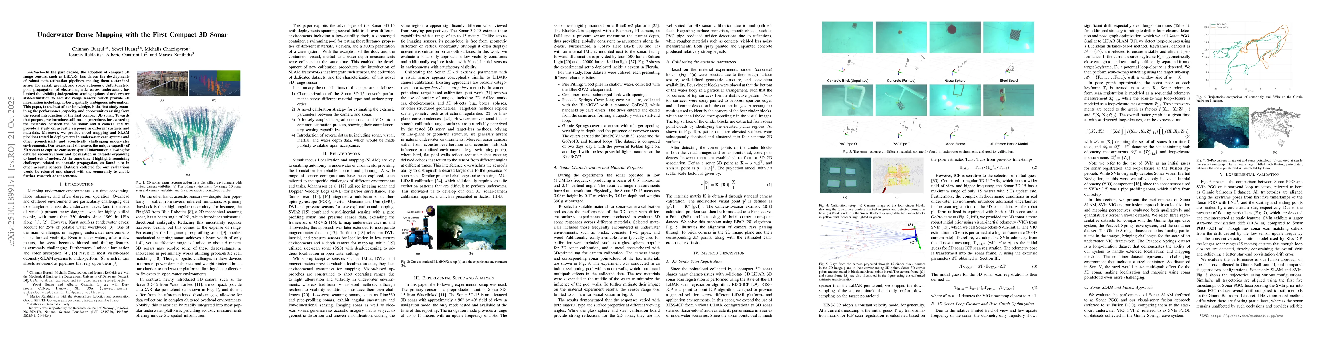
In the past decade, the adoption of compact 3D range sensors, such as LiDARs, has driven the developments of robust state-estimation pipelines, making them a standard sensor for aerial, ground, and space autonomy. Unfortunately, poor propagation of electromagnetic waves underwater, has limited the visibility-independent sensing options of underwater state-estimation to acoustic range sensors, which provide 2D information including, at-best, spatially ambiguous information. This paper, to the best of our knowledge, is the first study examining the performance, capacity, and opportunities arising from the recent introduction of the first compact 3D sonar. Towards that purpose, we introduce calibration procedures for extracting the extrinsics between the 3D sonar and a camera and we provide a study on acoustic response in different surfaces and materials. Moreover, we provide novel mapping and SLAM pipelines tested in deployments in underwater cave systems and other geometrically and acoustically challenging underwater environments. Our assessment showcases the unique capacity of 3D sonars to capture consistent spatial information allowing for detailed reconstructions and localization in datasets expanding to hundreds of meters. At the same time it highlights remaining challenges related to acoustic propagation, as found also in other acoustic sensors. Datasets collected for our evaluations would be released and shared with the community to enable further research advancements.

AI Key Findings

Generated Oct 24, 2025

Methodology — What approach did the authors take?

The research employed a combination of calibration strategies, SLAM pipelines, and underwater exploration in challenging environments to evaluate the performance of the Sonar3D-15 sensor.

Key Results — What are the main findings?

  • The fusion approach achieved a re-visitation error of 6.76 meters, close to the theoretical bound.
  • The system successfully reconstructed complex structures in acoustically challenging environments.
  • The integration of acoustic, visual, and inertial data improved localization accuracy in confined spaces.

Significance — Why does this research matter?

This research advances underwater robotics by providing robust mapping and exploration capabilities, enabling more effective navigation and data collection in challenging underwater environments.

Technical Contribution — What is the technical contribution?

The paper presents a novel calibration strategy and SLAM pipelines for 3D acoustic sensing, along with datasets for research acceleration.

Novelty — What is new about this work?

The work introduces a tightly coupled optimization framework integrating acoustic, visual, inertial, and depth data, differing from previous systems with non-overlapping fields of view.

Limitations — What are the limitations of this study?

  • Multipath effects still pose challenges in accurate range measurements.
  • Limited field of view in narrow tunnels caused systematic drift.

Future Work — What did the authors propose for future work?

  • Developing online correction methods using probabilistic map representations.
  • Exploring advanced representations like Gaussiansplatting for integration into state estimation processes.

Paper Details

Paper ID: 2510.18991
Comments: 8 pages, 12 figures
Categories:
cs.RO

How to Cite This Paper

BibTeX
@article{burgul2025underwater,
  title         = {Underwater Dense Mapping with the First Compact 3D Sonar},
  author        = {Burgul, Chinmay and Huang, Yewei and Chatzispyrou, Michalis and others},
  year          = {2025},
  eprint        = {2510.18991},
  archivePrefix = {arXiv},
  primaryClass  = {cs.RO},
}
APA 7
Burgul, C., Huang, Y., Chatzispyrou, M., Rekleitis, I., Li, A., & Xanthidis, M. (2025). Underwater Dense Mapping with the First Compact 3D Sonar. arXiv. https://arxiv.org/abs/2510.18991
MLA 9
Burgul, Chinmay, et al. "Underwater Dense Mapping with the First Compact 3D Sonar." arXiv, 2025, arxiv.org/abs/2510.18991.

Comments (0)

This website uses cookies to ensure you get the best experience. Learn more