This paper presents a method combining transfer learning and weak supervision to delineate crop fields in smallholder farming systems, overcoming the challenges of small field sizes and lack of ground labels. The approach achieves a median Intersection over Union (IoU) of 0.86 using high-resolution imagery and pre-training on a different region, significantly reducing the need for local labels.
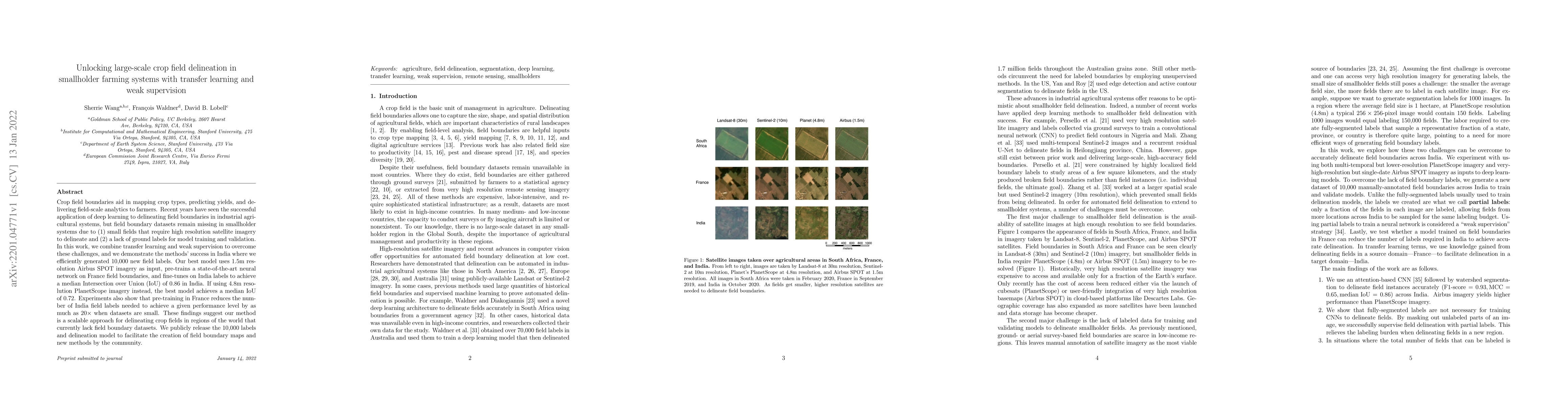
Crop field boundaries aid in mapping crop types, predicting yields, and delivering field-scale analytics to farmers. Recent years have seen the successful application of deep learning to delineating field boundaries in industrial agricultural systems, but field boundary datasets remain missing in smallholder systems due to (1) small fields that require high resolution satellite imagery to delineate and (2) a lack of ground labels for model training and validation. In this work, we combine transfer learning and weak supervision to overcome these challenges, and we demonstrate the methods' success in India where we efficiently generated 10,000 new field labels. Our best model uses 1.5m resolution Airbus SPOT imagery as input, pre-trains a state-of-the-art neural network on France field boundaries, and fine-tunes on India labels to achieve a median Intersection over Union (IoU) of 0.86 in India. If using 4.8m resolution PlanetScope imagery instead, the best model achieves a median IoU of 0.72. Experiments also show that pre-training in France reduces the number of India field labels needed to achieve a given performance level by as much as $20\times$ when datasets are small. These findings suggest our method is a scalable approach for delineating crop fields in regions of the world that currently lack field boundary datasets. We publicly release the 10,000 labels and delineation model to facilitate the creation of field boundary maps and new methods by the community.
This graph shows how this paper is connected to other research. The current paper is shown in dark gray, papers that cite it are in green, and papers it references are in blue. You can:
• Hover over any node to see the paper title
• Click a node to view that paper's details
• Drag nodes to rearrange the graph
• Use the zoom controls (bottom right) to zoom in/out
Title | Authors | Year | Actions |
---|---|---|---|
FieldSeg: A scalable agricultural field extraction framework based on the Segment Anything Model and 10-m Sentinel-2 imagery
|
Lucas B. Ferreira, Vitor S. Martins, U. R. Aires, N. Wijewardane, Xin Zhang, Sathishkumar Samiappan
|
2025
|
View Paper |
Extracting vectorized agricultural parcels from high-resolution satellite images using a Point-Line-Region interactive multitask model
|
Mengmeng Li, Chengwen Lu, Mengjing Lin, Xiaolong Xiu, Jiang Long, Xiaoqin Wang
|
2025
|
View Paper |
SIDEST: A sample-free framework for crop field boundary delineation by integrating super-resolution image reconstruction and dual edge-corrected Segment Anything model
|
Haoran Sun, Zhijian Wei, Weiguo Yu, Gaoxiang Yang, Junnan She, Hengbiao Zheng, Chongya Jiang, Xia Yao, Yan Zhu, Weixing Cao, T. Cheng, Iftikhar Ali
|
2025
|
View Paper |
Advancements in crop mapping through remote sensing: A comprehensive review of concept, data sources, and procedures over four decades
|
Iman Khosravi
|
2025
|
View Paper |
Non-Uniformity Correction of Spatial Object Images Using Multi-Scale Residual Cycle Network (CycleMRSNet)
|
Chunfeng Jiang, Zhengwei Li, Yubo Wang, Tao Chen
|
2025
|
View Paper |
To enhance sustainable development goal research, open up commercial satellite image archives
|
Philippe Rufin, P. Meyfroidt, Felicia O Akinyemi, Lyndon D. Estes, Esther Shupel Ibrahim, Meha Jain, Hannah Kerner, Sá Nogueira Lisboa, David B. Lobell, Catherine Nakalembe, Claudio Persello, Michelle C A Picoli, Natasha Ribeiro, A. Sitoe, Katharina Waha, Sherrie Wang
|
2025
|
View Paper |
Lightweight Deep Learning Model, ConvNeXt-U: An Improved U-Net Network for Extracting Cropland in Complex Landscapes from Gaofen-2 Images
|
Shukuan Liu, Shi Cao, Xia Lu, Jiqing Peng, Lina Ping, Xiang Fan, Feiyu Teng, Xiangnan Liu
|
2025
|
View Paper |
A cost-effective and robust mapping method for diverse crop types using weakly supervised semantic segmentation with sparse point samples
|
Zhiwen Cai, Baodong Xu, Qiangyi Yu, Xinyu Zhang, Jingya Yang, Haodong Wei, Shiqi Li, Qian Song, Hang Xiong, Hao Wu, Wenbin Wu, Zhihua Shi, Qiong Hu
|
2024
|
View Paper |
Transforming Agricultural Productivity with AI-Driven Forecasting: Innovations in Food Security and Supply Chain Optimization
|
S. Dhal, Debashish Kar
|
2024
|
View Paper |
CropSight: Towards a large-scale operational framework for object-based crop type ground truth retrieval using street view and PlanetScope satellite imagery
|
Yin Liu, C. Diao, Weiye Mei, Chishan Zhang
|
2024
|
View Paper |
Semantic Segmentation and Classification of Active and Abandoned Agricultural Fields through Deep Learning in the Southern Peruvian Andes
|
James Zimmer-Dauphinee, Steven A. Wernke
|
2024
|
View Paper |
Tackling fluffy clouds: field boundaries detection using time series of S2 and/or S1 imagery
|
F. Diakogiannis, Zheng-Shu Zhou, Jeff Wang, Gonzalo Mata, Dave Henry, R. Lawes, Amy Parker, P. Caccetta, Rodrigo Ibata, O. Hlinka, Jonathan Richetti, Kathryn Batchelor, Chris Herrmann, Andrew F. Toovey, John Taylor
|
2024
|
View Paper |
Satellite Sunroof: High-res Digital Surface Models and Roof Segmentation for Global Solar Mapping
|
Vishal Batchu, Alex Wilson, Betty Peng, Carl Elkin, Umangi Jain, Christopher Van Arsdale, Ross Goroshin, Varun Gulshan
|
2024
|
View Paper |
Evaluation of computer vision pipeline for farm-level analytics: A case study in Sugarcane
|
Sambal Shikhar, Rajiv Ranjan, Aman Sa, Anshika Srivastava, Yash Srivastava, Dinesh Kumar, Shashank Tamaskar, Anupam Sobti
|
2024
|
View Paper |
Advancing Application Development with Analysis-Ready Data in the Digital Earth Africa Program
|
Fang Yuan, Lisa-Maria Rebelo, Michael Wellington, Lavender Liu, Caitlin Adams, Meghan Halabisky, Mpho Sadiki, Edward Boamah, Adam Lewis, Lisa Hall, Maša Arnež, G. Milcinski
|
2024
|
View Paper |
Deep learning in cropland field identification: A review
|
Fan Xu, X. Yao, Kangxin Zhang, Hao Yang, Quanlong Feng, Ying Li, Shuai Yan, Bingbo Gao, Shaoshuai Li, Jianyu Yang, Chao Zhang, Yahui Lv, Dehai Zhu, Sijing Ye
|
2024
|
View Paper |
FieldSeg-DA2.0: Further enhancing the spatiotemporal transferability of an individual arable field (IAF) extraction network using multisource remote sensing and land cover data
|
Chun Tian, Xuehong Chen, Jin Chen, Ruyin Cao, Shuaijun Liu
|
2024
|
View Paper |
Investigating the Segment Anything Foundation Model for Mapping Smallholder Agriculture Field Boundaries Without Training Labels
|
Pratyush Tripathy, Kathy Baylis, Kyle Wu, Jyles Watson, Ruizhe Jiang
|
2024
|
View Paper |
OnionFoliageSET: Labeled dataset for small onion and foliage flower crop detection
|
Juan Felipe Restrepo-Arias, John W. Branch-Bedoya, Paulina Arregocés-Guerra
|
2024
|
View Paper |
Responsible AI for Earth Observation
|
Pedram Ghamisi, Weikang Yu, Andrea Marinoni, C. Gevaert, Claudio Persello, Sivasakthy Selvakumaran, Manuela Girotto, Benjamin P. Horton, Philippe Rufin, P. Hostert, Fabio Pacifici, Peter M. Atkinson
|
2024
|
View Paper |
Can we estimate farm size from field size? An empirical investigation of the field size to farm size relationship.
|
Clemens Jänicke, Maximilian Wesemeyer, Cristina Chiarella, Tobia Lakes, Christian Levers, P. Meyfroidt, Daniel Müller, Marie Pratzer, Philippe Rufin
|
2024
|
View Paper |
Multi-Region Transfer Learning for Segmentation of Crop Field Boundaries in Satellite Images with Limited Labels
|
Hannah Kerner, Saketh Sundar, Mathan Satish
|
2024
|
View Paper |
Spatially Explicit Active Learning for Crop-Type Mapping from Satellite Image Time Series
|
Beatrice Kaijage, Mariana Belgiu, W. Bijker
|
2024
|
View Paper |
Crop field extraction from high resolution remote sensing images based on semantic edges and spatial structure map
|
Liegang Xia, Ruiyan Liu, Yishao Su, Shulin Mi, Dezhi Yang, Jun Chen, Zhanfeng Shen
|
2024
|
View Paper |
A Unified Framework for Cropland Field Boundary Detection and Segmentation
|
Rodrigo Fill Rangel Seedz, Vítor Nascimento Lourenço Gaivota, Lucas Volochen Oldoni Seedz, Ana Flavia Carrara Bonamigo Seedz, Wallas Santos Gaivota, Bruno Silva Oliveira Seedz, Mateus Neves Barreto Seedz
|
2024
|
View Paper |
Taking it further: leveraging pseudo labels for field delineation across label-scarce smallholder regions
|
Philippe Rufin, Sherrie Wang, Sá Nogueira Lisboa, Jan Hemmerling, M. Tulbure, P. Meyfroidt
|
2023
|
View Paper |
AI for Agriculture: the Comparison of Semantic Segmentation Methods for Crop Mapping with Sentinel-2 Imagery
|
Irina Korotkova, Natalia Efremova
|
2023
|
View Paper |
Improving agricultural field parcel delineation with a dual branch spatiotemporal fusion network by integrating multimodal satellite data
|
Zhiwen Cai, Qiong Hu, Xinyu Zhang, Jingya Yang, Haodong Wei, Jiayue Wang, Yelu Zeng, Gaofei Yin, Wenjuan Li, Liangzhi You, Baodong Xu, Z. Shi
|
2023
|
View Paper |
Fewshot learning on global multimodal embeddings for earth observation tasks
|
Matt Allen, Francisco Dorr, Joseph A. Gallego-Mejia, Laura Mart'inez-Ferrer, Anna Jungbluth, Freddie Kalaitzis, Ra'ul Ramos-Poll'an
|
2023
|
View Paper |
Comparison of an Optimised Multiresolution Segmentation Approach with Deep Neural Networks for Delineating Agricultural Fields from Sentinel-2 Images
|
G. Tetteh, M. Schwieder, S. Erasmi, Christopher Conrad, A. Gocht
|
2023
|
View Paper |
Considerations for AI-EO for agriculture in Sub-Saharan Africa
|
C. Nakalembe, H. Kerner
|
2023
|
View Paper |
AI4Boundaries: an open AI-ready dataset to map field boundaries with Sentinel-2 and aerial photography
|
R. d’Andrimont, M. Claverie, P. Kempeneers, D. Muraro, Momchil Yordanov, D. Peressutti, M. Batič, F. Waldner
|
2023
|
View Paper |
Nonuniform Correction of Ground-Based Optical Telescope Image Based on Conditional Generative Adversarial Network
|
Xiangji Guo, Tao Chen, Junchi Liu, Yuan-Jui Liu, Q. An, Chunfeng Jiang
|
2023
|
View Paper |
Methodological approaches to identifying and mapping fields of specific crops on a basis of high-resolution satellite images using phenological, geographic, and regional statistical information
|
Alexey Unagaev, Irina Korotkova, Natalia Efremova
|
2025
|
View Paper |
A novel architecture for automated delineation of the agricultural fields using partial training data in remote sensing images
|
Sumesh Kc, J. Aryal, Dongryeol Ryu
|
2025
|
View Paper |
A Deep Learning Method for Cultivated Land Parcels’ (CLPs) Delineation From High-Resolution Remote Sensing Images With High-Generalization Capability
|
Yu Zhu, Yaozhong Pan, Dujuan Zhang, Hanyi Wu, Chuanwu Zhao
|
2024
|
View Paper |
AI4SmallFarms: A Dataset for Crop Field Delineation in Southeast Asian Smallholder Farms
|
C. Persello, Jeroen Grift, Xinyan Fan, Claudia Paris, R. Hänsch, M. Koeva, Andrew Nelson
|
2023
|
View Paper |
Creating Next Generation Field Boundary and Crop Type Maps Rigorous Multi-Scale Groundtruth Provides Sustainable Extension
|
2022
|
View Paper | |
Supporting
|
Matthias Klückmann
|
2020
|
View Paper |
Untangling intercropping in heterogeneous smallholder maize-cassava farming systems 1 with remote sensing
|
Felicia O. Akinyemi, Philippe Rufin, Esther Shupel, P. Hostert, L. Ogunsumi, O. Egbetokun, Ifejika Speranza
|
View Paper |
Jan Hemmerling, Philippe Rufin, Patrick Meyfroidt, Sherrie Wang, Sá Nogueira Lisboa, Mirela G. Tulbure
Published: 2023-12-15
Sherrie Wang, Jordi Laguarta Soler, Thomas Friedel
Published: 2024-02-01
Hannah Kerner, Saketh Sundar, Mathan Satish
Published: 2024-04-02
Saba Zahid, Sajid Ghuffar, Obaid-ur-Rehman, Syed Roshaan Ali Shah
Published: 2024-11-24
Comments (0)