VoxCity: A Seamless Framework for Open Geospatial Data Integration, Grid-Based Semantic 3D City Model Generation, and Urban Environment Simulation

Source: ArXiv

AI Quick Summary

VoxCity is an open-source Python package that automates 3D city model generation and urban environment simulation for cities worldwide, reducing manual effort and promoting sustainable urban design.

Share: Share on X LinkedIn

Summary

Three-dimensional urban environment simulation is a powerful tool for informed urban planning. However, the intensive manual effort required to prepare input 3D city models has hindered its widespread adoption. To address this challenge, we present VoxCity, an open-source Python package that provides a one-stop solution for grid-based 3D city model generation and urban environment simulation for cities worldwide. VoxCity's `generator' subpackage automatically downloads building heights, tree canopy heights, land cover, and terrain elevation within a specified target area, and voxelizes buildings, trees, land cover, and terrain to generate an integrated voxel city model. The `simulator' subpackage enables users to conduct environmental simulations, including solar radiation and view index analyses. Users can export the generated models using several file formats compatible with external software, such as ENVI-met (INX), Blender, and Rhino (OBJ). We generated 3D city models for eight global cities, and demonstrated the calculation of solar irradiance, sky view index, and green view index. We also showcased microclimate simulation and 3D rendering visualization through ENVI-met and Rhino, respectively, through the file export function. Additionally, we reviewed openly available geospatial data to create guidelines to help users choose appropriate data sources depending on their target areas and purposes. VoxCity can significantly reduce the effort and time required for 3D city model preparation and promote the utilization of urban environment simulations. This contributes to more informed urban and architectural design that considers environmental impacts, and in turn, fosters sustainable and livable cities. VoxCity is released openly at https://github.com/kunifujiwara/VoxCity.
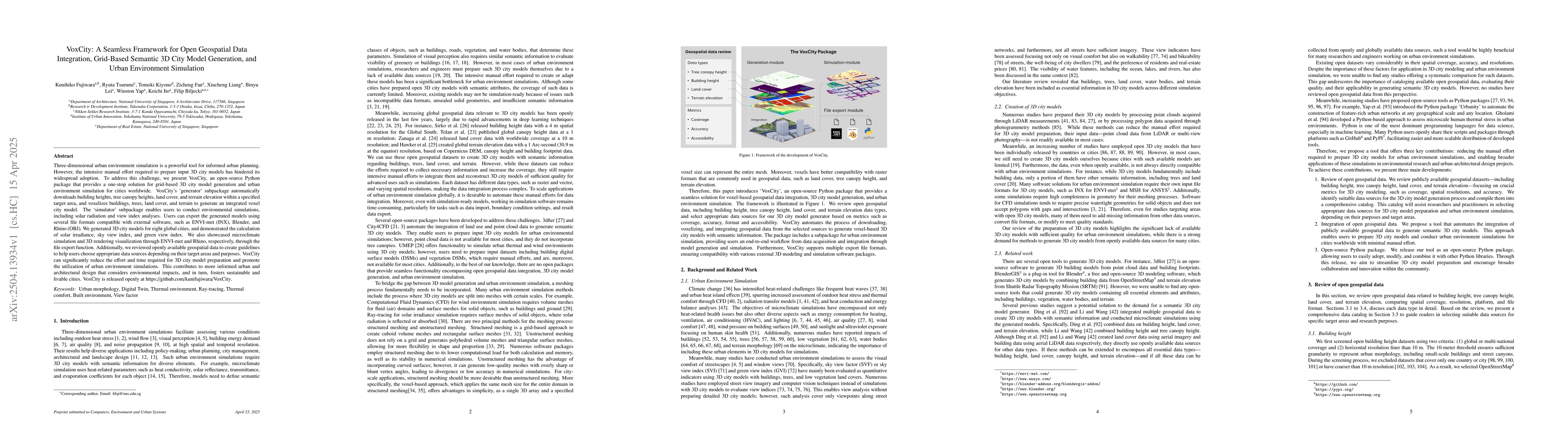
AI Key Findings

Generated Jun 09, 2025

Methodology

VoxCity is a Python package that integrates open geospatial data for 3D city model generation and urban environment simulation, focusing on building height, tree canopy height, land cover, and terrain elevation.

Key Results

  • VoxCity automatically downloads and voxelizes these datasets to create integrated 3D city models.
  • The framework supports various simulations, including solar radiation and view index analyses.

Significance

This research significantly reduces manual effort in preparing 3D city models, promoting the use of urban environment simulations for informed urban planning and sustainable city development.

Technical Contribution

VoxCity provides a seamless, automatic method for preparing 3D city models and running urban environment simulations, integrating four geospatial data types to generate semantic 3D city models.

Novelty

VoxCity stands out by offering a comprehensive, end-to-end solution for 3D city model generation, urban environment simulations, and visualization, leveraging data from OSM to maintain up-to-date representations of urban forms.

Limitations

  • VoxCity currently does not support complex civil engineering structures like bridges and elevated highways.
  • The processing time can vary depending on selected data sources.

Future Work

  • Integration of advanced 3D data models (e.g., CityGML, CityJSON) for broader interdisciplinary adoption.
  • Incorporation of building surface material information and window-to-wall ratio (WWR) for detailed urban environment simulations.

Paper Details

PDF Preview

Download PDF

Citation Network

Current paper (gray), citations (green), references (blue)

Display is limited for performance on very large graphs.

Current Paper
Citations
References
Click to view

No citations found for this paper.

Comments (0)

This website uses cookies to ensure you get the best experience. Learn more