ArxivLens
ArXiv cs.RO cs.CV

WildOS: Open-Vocabulary Object Search in the Wild

Deegan Atha, Erica Tevere, Hardik Shah, Jonas Frey, Manthan Patel, Marcel Kaufmann, Marco Hutter, Patrick Spieler

2602.19308 Published Feb 22, 2026
View PDF

Publication

Published: Feb 22, 2026
Categories: cs.RO, cs.CV

Metrics

Source: ArXiv

Quick Answers

What methodology did the authors use?

WildOS integrates a sparse navigation graph with a foundation-model-based vision module (ExploRFM) that scores frontier nodes for traversability, visual frontiers, and object similarity; it uses particle-based triangulation for coarse target localization and a goal-agnostic multi-headings scoring strategy for robust exploration. More in Methodology →

What are the key results?

WildOS outperforms purely geometric and purely vision-based baselines in both trajectory length and traversal time across diverse off-road and urban terrains. — The system achieves successful end-to-end open-vocabulary object search from language queries, including zero-shot generalization to unseen categories. More in Key Results →

Why is this work significant?

By combining foundation-model visual reasoning with geometric memory, WildOS demonstrates that robots can autonomously navigate long-range, unstructured outdoor environments while grounding arbitrary language queries, paving the way for scalable, open-world robotic exploration. More in Significance →

What are the main limitations?

The particle-based triangulation and visual scoring rely on accurate depth ranges; performance degrades when depth estimates are noisy or when objects are occluded. — The system exhibits oscillatory behavior in long-horizon exploration due to limited horizon planning and may require manual intervention in highly dynamic settings. More in Limitations →

Paper Preview

Abstract

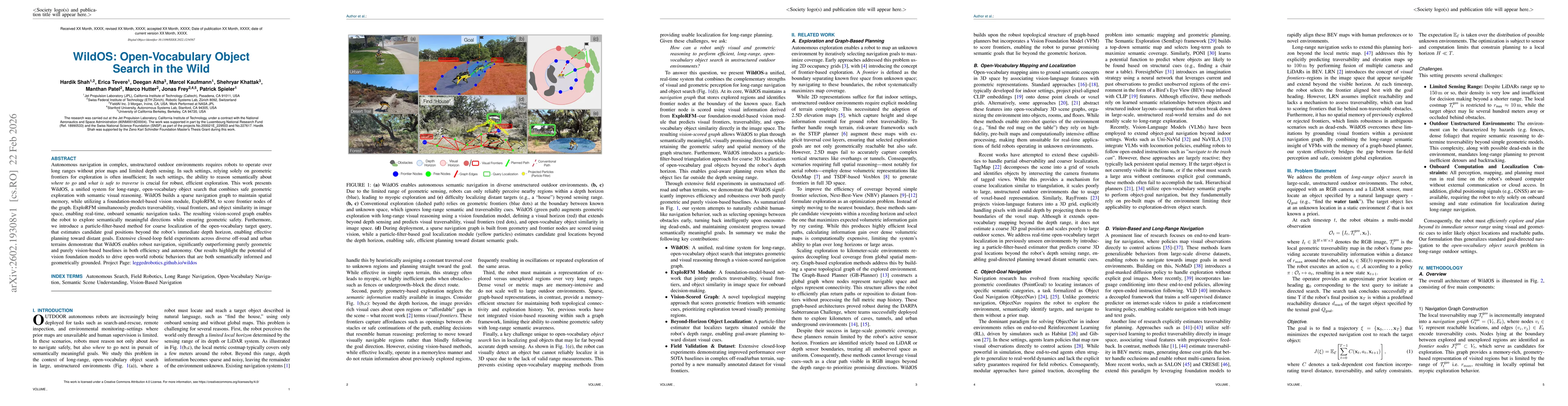
Autonomous navigation in complex, unstructured outdoor environments requires robots to operate over long ranges without prior maps and limited depth sensing. In such settings, relying solely on geometric frontiers for exploration is often insufficient. In such settings, the ability to reason semantically about where to go and what is safe to traverse is crucial for robust, efficient exploration. This work presents WildOS, a unified system for long-range, open-vocabulary object search that combines safe geometric exploration with semantic visual reasoning. WildOS builds a sparse navigation graph to maintain spatial memory, while utilizing a foundation-model-based vision module, ExploRFM, to score frontier nodes of the graph. ExploRFM simultaneously predicts traversability, visual frontiers, and object similarity in image space, enabling real-time, onboard semantic navigation tasks. The resulting vision-scored graph enables the robot to explore semantically meaningful directions while ensuring geometric safety. Furthermore, we introduce a particle-filter-based method for coarse localization of the open-vocabulary target query, that estimates candidate goal positions beyond the robot's immediate depth horizon, enabling effective planning toward distant goals. Extensive closed-loop field experiments across diverse off-road and urban terrains demonstrate that WildOS enables robust navigation, significantly outperforming purely geometric and purely vision-based baselines in both efficiency and autonomy. Our results highlight the potential of vision foundation models to drive open-world robotic behaviors that are both semantically informed and geometrically grounded. Project Page: https://leggedrobotics.github.io/wildos/

Key Findings, in focus

Seven facets of this paper, analysed and brought into focus by AI.

AI-generated · verify against source Generated Feb 24, 2026
In focus · one-line synthesis

By combining foundation-model visual reasoning with geometric memory, WildOS demonstrates that robots can autonomously navigate long-range, unstructured outdoor environments while grounding arbitrary language queries, paving the way for scalable, open-world robotic exploration.

01
MethodologyHow they did it

WildOS integrates a sparse navigation graph with a foundation-model-based vision module (ExploRFM) that scores frontier nodes for traversability, visual frontiers, and object similarity; it uses particle-based triangulation for coarse target localization and a goal-agnostic multi-headings scoring strategy for robust exploration.

02
ResultsWhat they found
  • WildOS outperforms purely geometric and purely vision-based baselines in both trajectory length and traversal time across diverse off-road and urban terrains.
  • The system achieves successful end-to-end open-vocabulary object search from language queries, including zero-shot generalization to unseen categories.
  • Maintaining a scored navigation graph with visual-semantic memory enables robust recovery from dead-ends and reduces oscillatory behavior compared to memory-less vision-only planners.
03
SignificanceWhy it matters

By combining foundation-model visual reasoning with geometric memory, WildOS demonstrates that robots can autonomously navigate long-range, unstructured outdoor environments while grounding arbitrary language queries, paving the way for scalable, open-world robotic exploration.

04
Technical ContributionsWhat's new technically

A scored navigation graph that fuses geometric frontiers with vision-based semantic scores, enabling efficient high-level planning that respects both traversability and object similarity, along with a particle-based triangulation method for coarse target localization.

05
NoveltyWhat sets it apart

First open-vocabulary object search system operating in unstructured outdoor settings that leverages foundation-model vision for real-time semantic scoring, combined with a memory-aware navigation graph, achieving zero-shot generalization without task-specific training.

06
LimitationsWhat to be cautious about
  • The particle-based triangulation and visual scoring rely on accurate depth ranges; performance degrades when depth estimates are noisy or when objects are occluded.
  • The system exhibits oscillatory behavior in long-horizon exploration due to limited horizon planning and may require manual intervention in highly dynamic settings.
07
Future WorkWhere it goes next
  • Develop hierarchical or global planning modules to extend horizon planning beyond the current visual horizon and mitigate oscillations.
  • Integrate additional sensory modalities (e.g., thermal, LiDAR point cloud segmentation) to improve robustness in low-visibility or cluttered environments.

Paper Details

Paper ID: 2602.19308
Comments: 28 pages, 16 figures, 2 tables
Categories:
cs.RO cs.CV

How to Cite This Paper

Reference manager: RIS EndNote

Related Papers

4 found


Discussion 0

This website uses cookies to ensure you get the best experience. Learn more