ArxivLens

Publication

Published: Apr 08, 2026
Categories: cs.CL, cs.AI

Metrics

Source: ArXiv

Quick Answers

What methodology did the authors use?

DFR-Gemma aligns high-dimensional geospatial embeddings with an LLM’s latent space using a lightweight two‑layer MLP projector, injects the projected embeddings as soft tokens interleaved with natural language prompts, and trains the system on a multi‑task geospatial QA benchmark that includes single‑ and multi‑embedding queries, feature description, and comparison tasks. More in Methodology →

What are the key results?

DFR-Gemma achieves up to 33% higher accuracy on complex multi‑embedding reasoning tasks compared to text‑based baselines while using fewer tokens. — The projector‑only training regime preserves the LLM’s core reasoning abilities and yields performance comparable to full‑model fine‑tuning, avoiding catastrophic forgetting. More in Key Results →

Why is this work significant?

By enabling LLMs to reason directly over dense geospatial embeddings, the work eliminates token‑inefficient textualization, reduces computational cost, and provides a scalable, robust foundation for multimodal geospatial intelligence applications. More in Significance →

What are the main limitations?

Performance depends on the quality and richness of the underlying geospatial foundation model (e.g., PDFM). — The approach has been validated mainly on 4‑B parameter LLMs; scalability to larger models or different architectures remains to be explored. More in Limitations →

Paper Preview

Abstract

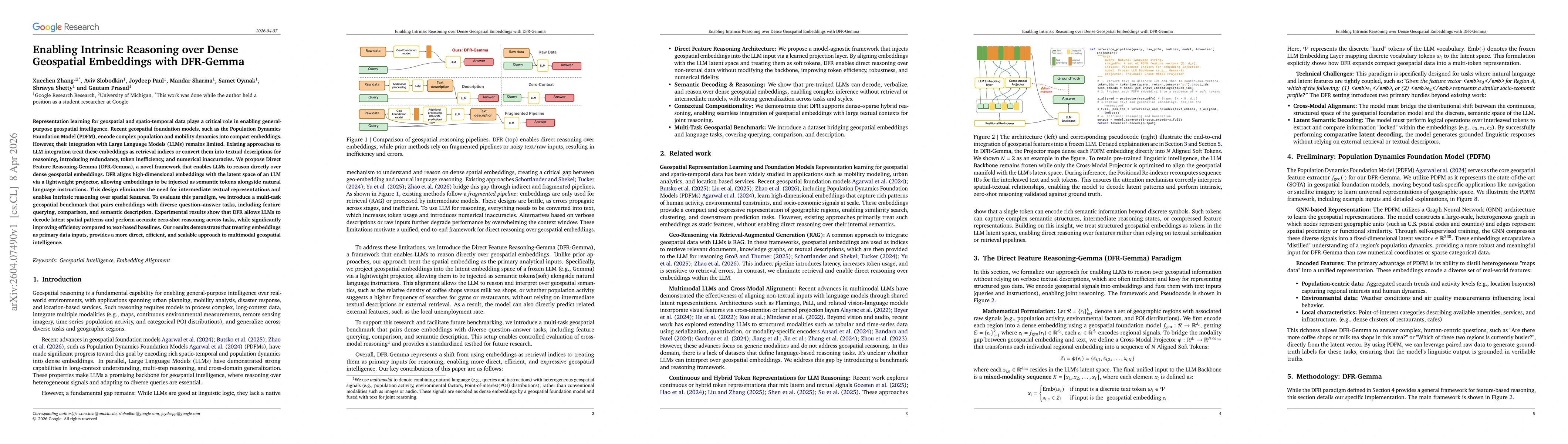
Representation learning for geospatial and spatio-temporal data plays a critical role in enabling general-purpose geospatial intelligence. Recent geospatial foundation models, such as the Population Dynamics Foundation Model (PDFM), encode complex population and mobility dynamics into compact embeddings. However, their integration with Large Language Models (LLMs) remains limited. Existing approaches to LLM integration treat these embeddings as retrieval indices or convert them into textual descriptions for reasoning, introducing redundancy, token inefficiency, and numerical inaccuracies. We propose Direct Feature Reasoning-Gemma (DFR-Gemma), a novel framework that enables LLMs to reason directly over dense geospatial embeddings. DFR aligns high-dimensional embeddings with the latent space of an LLM via a lightweight projector, allowing embeddings to be injected as semantic tokens alongside natural language instructions. This design eliminates the need for intermediate textual representations and enables intrinsic reasoning over spatial features. To evaluate this paradigm, we introduce a multi-task geospatial benchmark that pairs embeddings with diverse question-answer tasks, including feature querying, comparison, and semantic description. Experimental results show that DFR allows LLMs to decode latent spatial patterns and perform accurate zero-shot reasoning across tasks, while significantly improving efficiency compared to text-based baselines. Our results demonstrate that treating embeddings as primary data inputs, provides a more direct, efficient, and scalable approach to multimodal geospatial intelligence.

Key Findings, in focus

Seven facets of this paper, analysed and brought into focus by AI.

AI-generated · verify against source Generated Apr 11, 2026
In focus · one-line synthesis

By enabling LLMs to reason directly over dense geospatial embeddings, the work eliminates token‑inefficient textualization, reduces computational cost, and provides a scalable, robust foundation for multimodal geospatial intelligence applications.

01
MethodologyHow they did it

DFR-Gemma aligns high-dimensional geospatial embeddings with an LLM’s latent space using a lightweight two‑layer MLP projector, injects the projected embeddings as soft tokens interleaved with natural language prompts, and trains the system on a multi‑task geospatial QA benchmark that includes single‑ and multi‑embedding queries, feature description, and comparison tasks.

02
ResultsWhat they found
  • DFR-Gemma achieves up to 33% higher accuracy on complex multi‑embedding reasoning tasks compared to text‑based baselines while using fewer tokens.
  • The projector‑only training regime preserves the LLM’s core reasoning abilities and yields performance comparable to full‑model fine‑tuning, avoiding catastrophic forgetting.
  • DFR-Gemma demonstrates strong robustness to linguistic style changes and geographic distribution shifts, outperforming baselines that rely on textual descriptions or retrieval pipelines.
  • Hybrid contrastive learning further improves alignment but is optional, showing the projector’s effectiveness even with pure language‑model loss.
  • The mixed (shared‑projector) training strategy outperforms task‑specific projectors on multi‑task settings, indicating better generalization.
03
SignificanceWhy it matters

By enabling LLMs to reason directly over dense geospatial embeddings, the work eliminates token‑inefficient textualization, reduces computational cost, and provides a scalable, robust foundation for multimodal geospatial intelligence applications.

04
Technical ContributionsWhat's new technically

A lightweight projector‑based alignment module that maps dense geospatial embeddings into an LLM’s latent space, enabling intrinsic reasoning via soft token injection, and a multi‑task benchmark that demonstrates efficiency, robustness, and parameter‑efficiency.

05
NoveltyWhat sets it apart

First framework to treat dense geospatial embeddings as primary inputs to an LLM, avoiding intermediate textualization, and to demonstrate that soft token injection yields superior accuracy, token efficiency, and robustness compared to existing retrieval‑or‑description‑based pipelines.

06
LimitationsWhat to be cautious about
  • Performance depends on the quality and richness of the underlying geospatial foundation model (e.g., PDFM).
  • The approach has been validated mainly on 4‑B parameter LLMs; scalability to larger models or different architectures remains to be explored.
07
Future WorkWhere it goes next
  • Extend the framework to additional modalities such as satellite imagery and temporal dynamics for broader geospatial intelligence.
  • Investigate adaptive calibration techniques (few‑shot or contrastive) for rapid domain shift adaptation and integration with retrieval‑augmented generation pipelines.

Paper Details

Paper ID: 2604.07490
Categories:
cs.CL cs.AI

How to Cite This Paper

Reference manager: RIS EndNote


Discussion 0

This website uses cookies to ensure you get the best experience. Learn more