Mesogeos: A multi-purpose dataset for data-driven wildfire modeling in the Mediterranean
Publication
Metrics
AI Quick Summary
Mesogeos is a comprehensive dataset for wildfire modeling in the Mediterranean, integrating key variables and historical wildfire data. It aims to facilitate machine learning applications in forecasting wildfire danger and estimating burned areas.
Paper Preview
Abstract
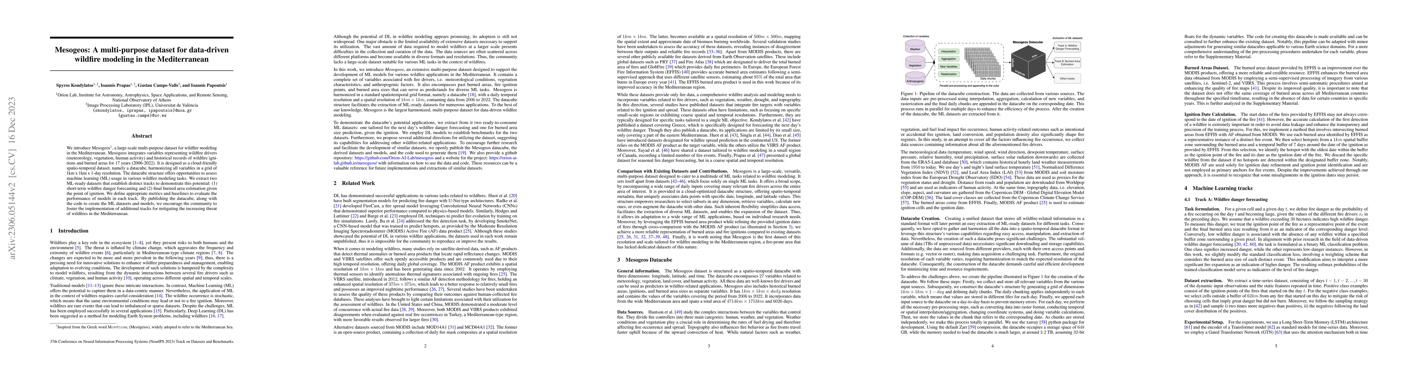
We introduce Mesogeos, a large-scale multi-purpose dataset for wildfire modeling in the Mediterranean. Mesogeos integrates variables representing wildfire drivers (meteorology, vegetation, human activity) and historical records of wildfire ignitions and burned areas for 17 years (2006-2022). It is designed as a cloud-friendly spatio-temporal dataset, namely a datacube, harmonizing all variables in a grid of 1km x 1km x 1-day resolution. The datacube structure offers opportunities to assess machine learning (ML) usage in various wildfire modeling tasks. We extract two ML-ready datasets that establish distinct tracks to demonstrate this potential: (1) short-term wildfire danger forecasting and (2) final burned area estimation given the point of ignition. We define appropriate metrics and baselines to evaluate the performance of models in each track. By publishing the datacube, along with the code to create the ML datasets and models, we encourage the community to foster the implementation of additional tracks for mitigating the increasing threat of wildfires in the Mediterranean.
AI Key Findings
Get AI-generated insights about this paper's methodology, results, significance, and more — seven facets brought into focus.
Impact
Paper Details
Authors
PDF Preview
Key Terms
Citation Network
Current paper (gray), citations (green), references (blue)
Display is limited for performance on very large graphs.
Discussion 0