Quick Answers
What methodology did the authors use?
The research proposes a traversability-aware situational graph construction method that integrates robot-terrain interaction information with semantic scene understanding. It employs hierarchical representations for real-time localization and mapping, combining LiDAR data with semantic segmentation to build more meaningful and consistent scene graphs. More in Methodology →
What are the key results?
Achieved higher room re-detection frequency compared to S-graphs+ and existing methods — Improved semantic consistency with higher DCS scores through better scene graph construction More in Key Results →
Why is this work significant?
This research advances semantic SLAM systems by creating more accurate and contextually meaningful scene representations, which can improve robot navigation reliability and efficiency in structured indoor environments. More in Significance →
What are the main limitations?
Dependence on high-quality LiDAR data which may limit real-world applicability — Computational complexity may affect real-time performance in resource-constrained systems More in Limitations →
Abstract
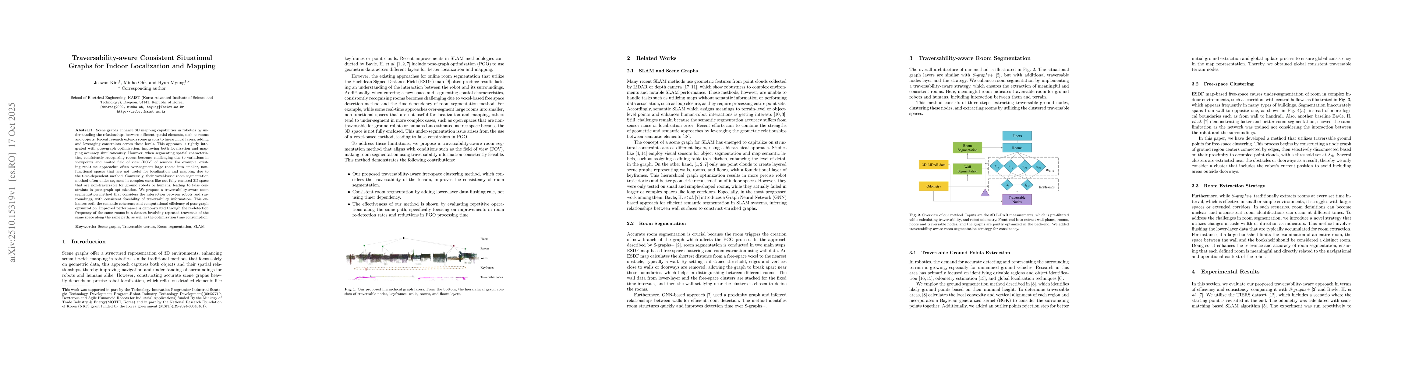
Scene graphs enhance 3D mapping capabilities in robotics by understanding the relationships between different spatial elements, such as rooms and objects. Recent research extends scene graphs to hierarchical layers, adding and leveraging constraints across these levels. This approach is tightly integrated with pose-graph optimization, improving both localization and mapping accuracy simultaneously. However, when segmenting spatial characteristics, consistently recognizing rooms becomes challenging due to variations in viewpoints and limited field of view (FOV) of sensors. For example, existing real-time approaches often over-segment large rooms into smaller, non-functional spaces that are not useful for localization and mapping due to the time-dependent method. Conversely, their voxel-based room segmentation method often under-segment in complex cases like not fully enclosed 3D space that are non-traversable for ground robots or humans, leading to false constraints in pose-graph optimization. We propose a traversability-aware room segmentation method that considers the interaction between robots and surroundings, with consistent feasibility of traversability information. This enhances both the semantic coherence and computational efficiency of pose-graph optimization. Improved performance is demonstrated through the re-detection frequency of the same rooms in a dataset involving repeated traversals of the same space along the same path, as well as the optimization time consumption.
AI Key Findings
Generated Oct 20, 2025
Methodology — What approach did the authors take?
The research proposes a traversability-aware situational graph construction method that integrates robot-terrain interaction information with semantic scene understanding. It employs hierarchical representations for real-time localization and mapping, combining LiDAR data with semantic segmentation to build more meaningful and consistent scene graphs.
Key Results — What are the main findings?
- Achieved higher room re-detection frequency compared to S-graphs+ and existing methods
- Improved semantic consistency with higher DCS scores through better scene graph construction
- Reduced PGO time consumption by eliminating redundant room extractions
Significance — Why does this research matter?
This research advances semantic SLAM systems by creating more accurate and contextually meaningful scene representations, which can improve robot navigation reliability and efficiency in structured indoor environments.
Technical Contribution — What is the technical contribution?
Proposed a novel traversability-aware framework that enhances situational graph construction through semantic-terrain interaction modeling and efficient hierarchical representation techniques
Novelty — What is new about this work?
Introduces a method that explicitly incorporates robot-terrain interaction information into scene graph construction, providing more meaningful semantic context compared to previous approaches that focused solely on geometric representations
Limitations — What are the limitations of this study?
- Dependence on high-quality LiDAR data which may limit real-world applicability
- Computational complexity may affect real-time performance in resource-constrained systems
Future Work — What did the authors propose for future work?
- Exploring how free-space clustering varies with sensor orientation and height
- Assessing segmentation consistency across different robot platforms
- Developing cooperative scene graph construction in multi-platform environments
Paper Details
How to Cite This Paper
@article{myung2025traversability,
title = {Traversability-aware Consistent Situational Graphs for Indoor
Localization and Mapping},
author = {Myung, Hyun and Kim, Jeewon and Oh, Minho},
year = {2025},
eprint = {2510.15319},
archivePrefix = {arXiv},
primaryClass = {cs.RO},
}
Myung, H., Kim, J., & Oh, M. (2025). Traversability-aware Consistent Situational Graphs for Indoor
Localization and Mapping. arXiv. https://arxiv.org/abs/2510.15319
Myung, Hyun, et al. "Traversability-aware Consistent Situational Graphs for Indoor
Localization and Mapping." arXiv, 2025, arxiv.org/abs/2510.15319.
PDF Preview
Similar Papers
Found 4 papersTACS-Graphs: Traversability-Aware Consistent Scene Graphs for Ground Robot Indoor Localization and Mapping
Jeewon Kim, Minho Oh, Hyun Myung
Situational Graphs for Robot Navigation in Structured Indoor Environments
Hriday Bavle, Muhammad Shaheer, Jose Luis Sanchez-Lopez et al.
Advanced Situational Graphs for Robot Navigation in Structured Indoor Environments
Hriday Bavle, Jose Luis Sanchez-Lopez, Muhammad Shaheer et al.
Towards Ubiquitous Mapping and Localization for Dynamic Indoor Environments
Halim Djerroud, Nico Steyn, Olivier Rabreau et al.
Comments (0)