Academic Profile
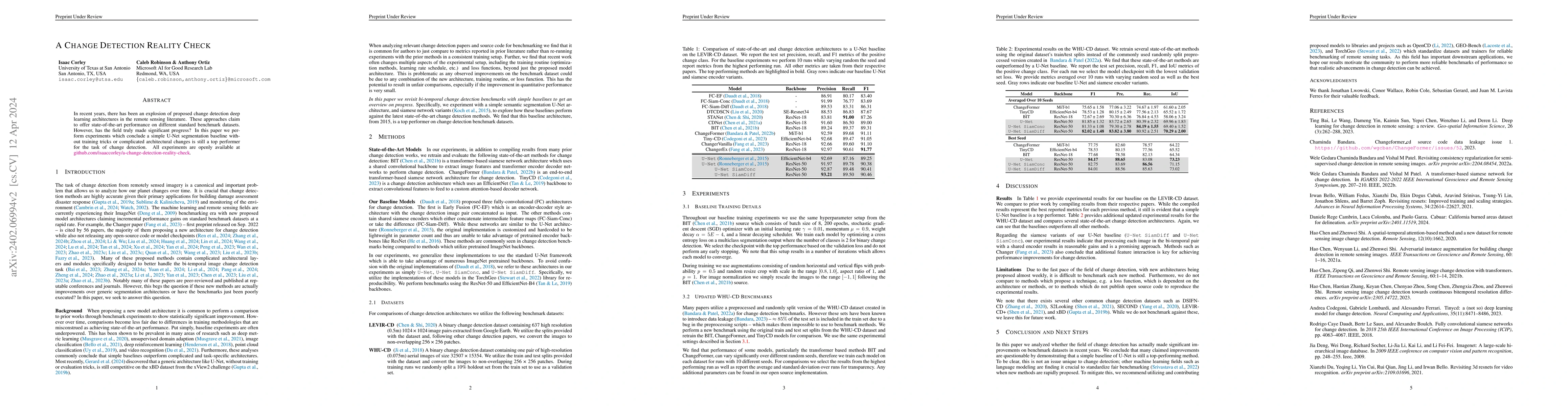
Statistics
Similar Authors
Papers on arXiv
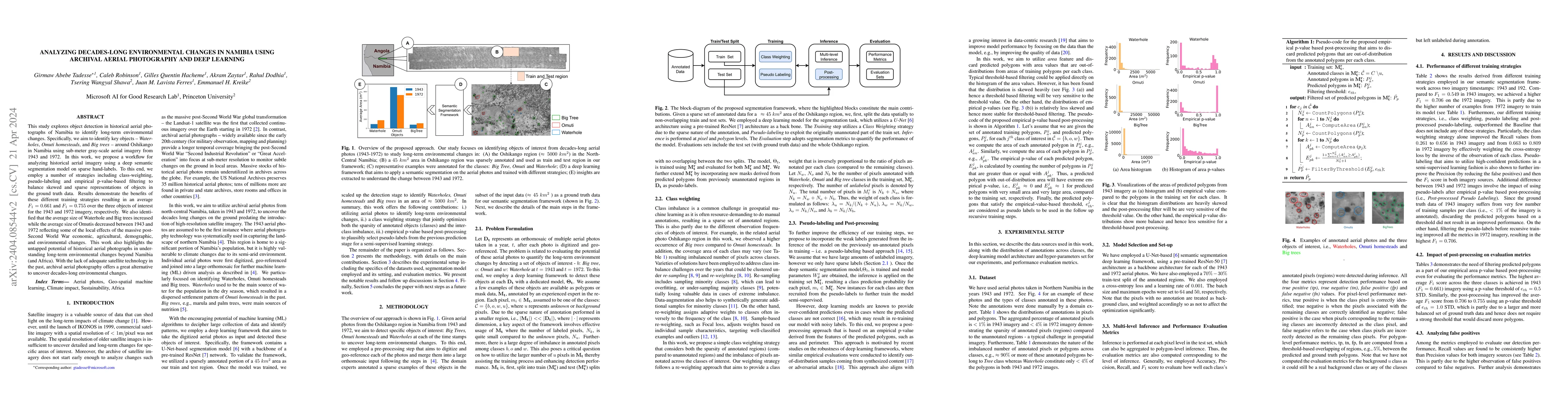
This study explores object detection in historical aerial photographs of Namibia to identify long-term environmental changes. Specifically, we aim to identify key objects -- Waterholes, Omuti homest...
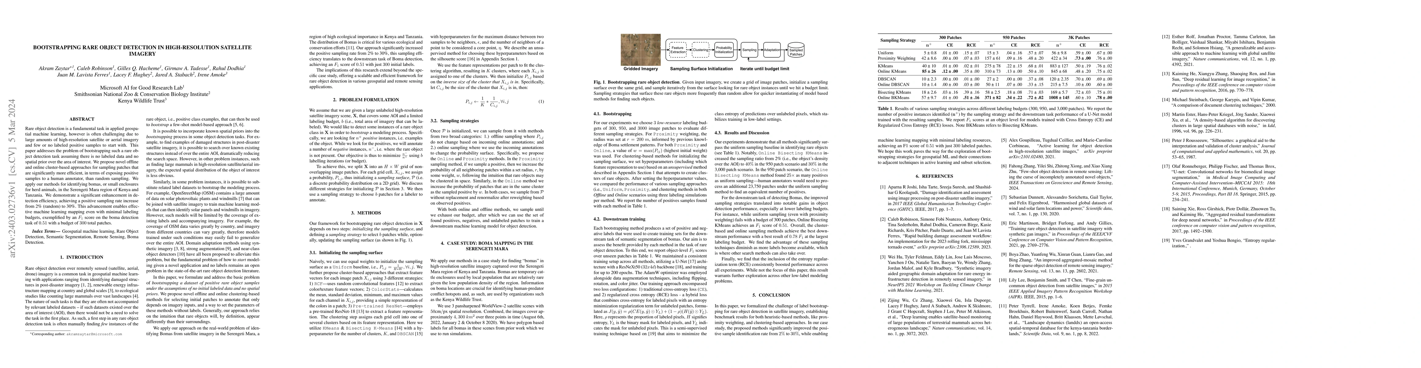
Rare object detection is a fundamental task in applied geospatial machine learning, however is often challenging due to large amounts of high-resolution satellite or aerial imagery and few or no lab...
In recent years, there has been an explosion of proposed change detection deep learning architectures in the remote sensing literature. These approaches claim to offer state-of-the-art performance o...
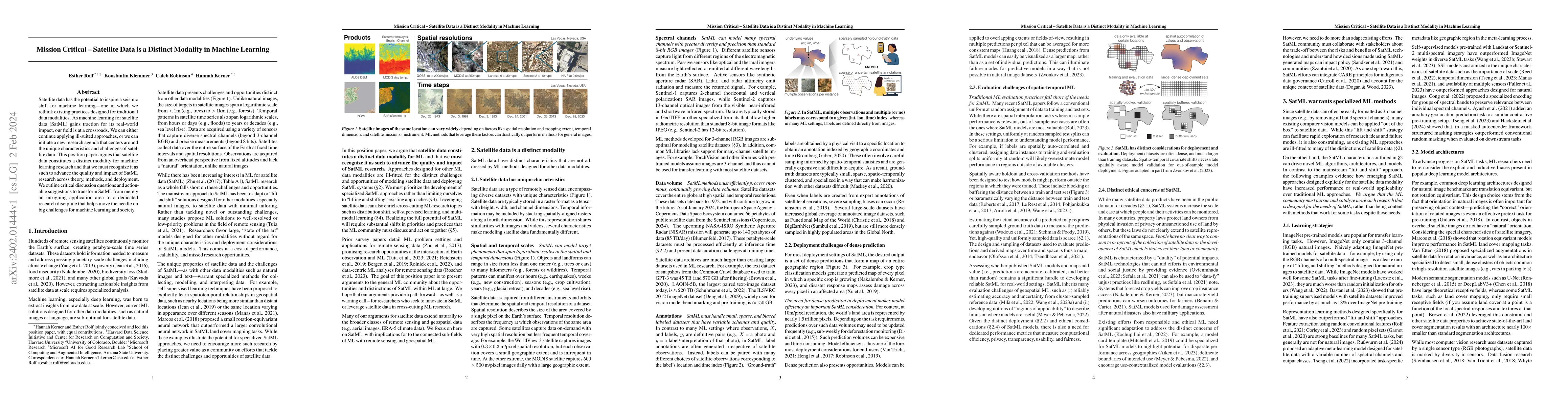
Satellite data has the potential to inspire a seismic shift for machine learning -- one in which we rethink existing practices designed for traditional data modalities. As machine learning for satel...
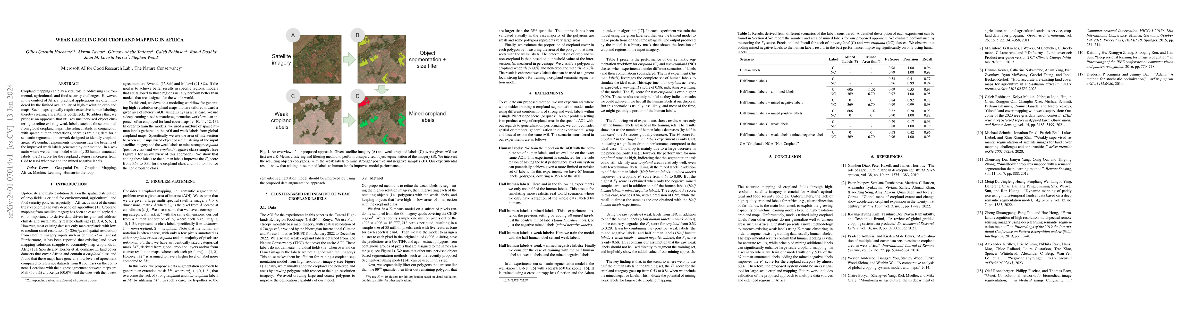
Cropland mapping can play a vital role in addressing environmental, agricultural, and food security challenges. However, in the context of Africa, practical applications are often hindered by the li...
Fully understanding a complex high-resolution satellite or aerial imagery scene often requires spatial reasoning over a broad relevant context. The human object recognition system is able to underst...
This paper introduces a no-code, machine-readable documentation framework for open datasets, with a focus on responsible AI (RAI) considerations. The framework aims to improve comprehensibility, and...
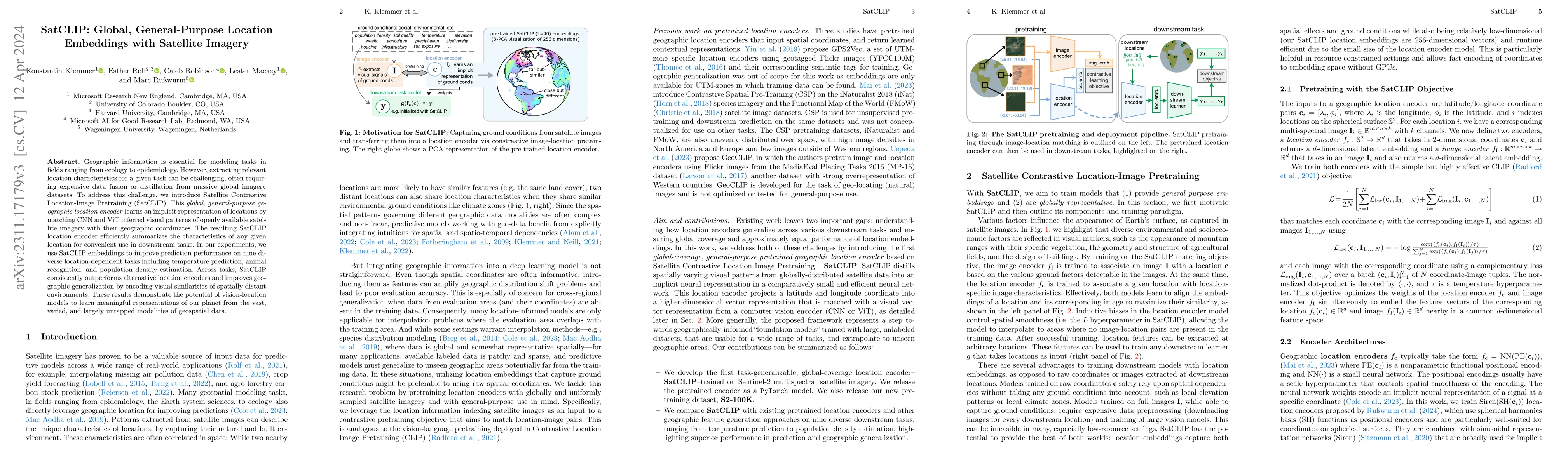
Geographic information is essential for modeling tasks in fields ranging from ecology to epidemiology. However, extracting relevant location characteristics for a given task can be challenging, ofte...
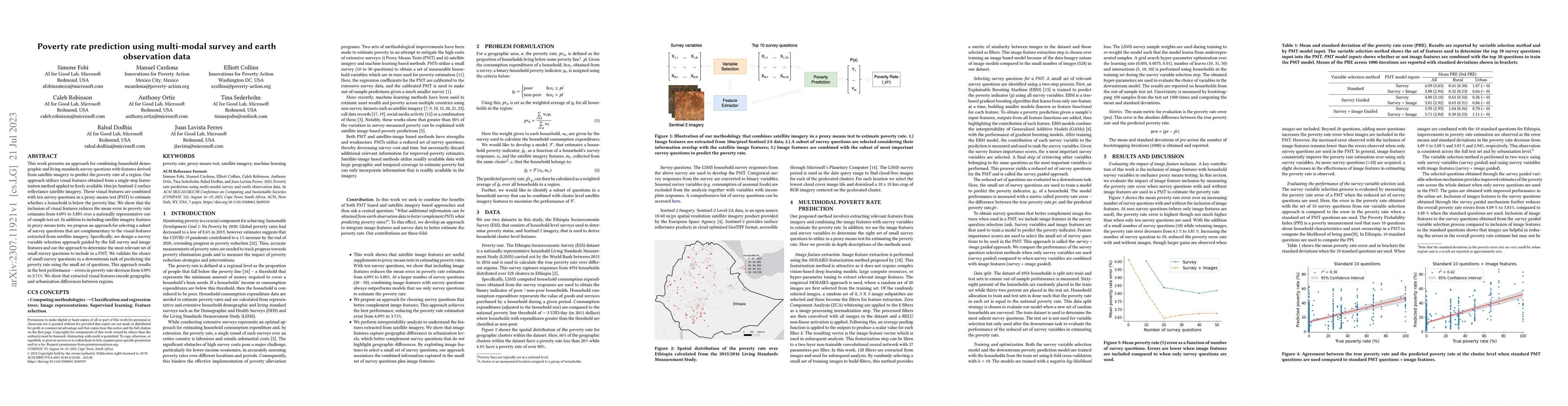
This work presents an approach for combining household demographic and living standards survey questions with features derived from satellite imagery to predict the poverty rate of a region. Our app...
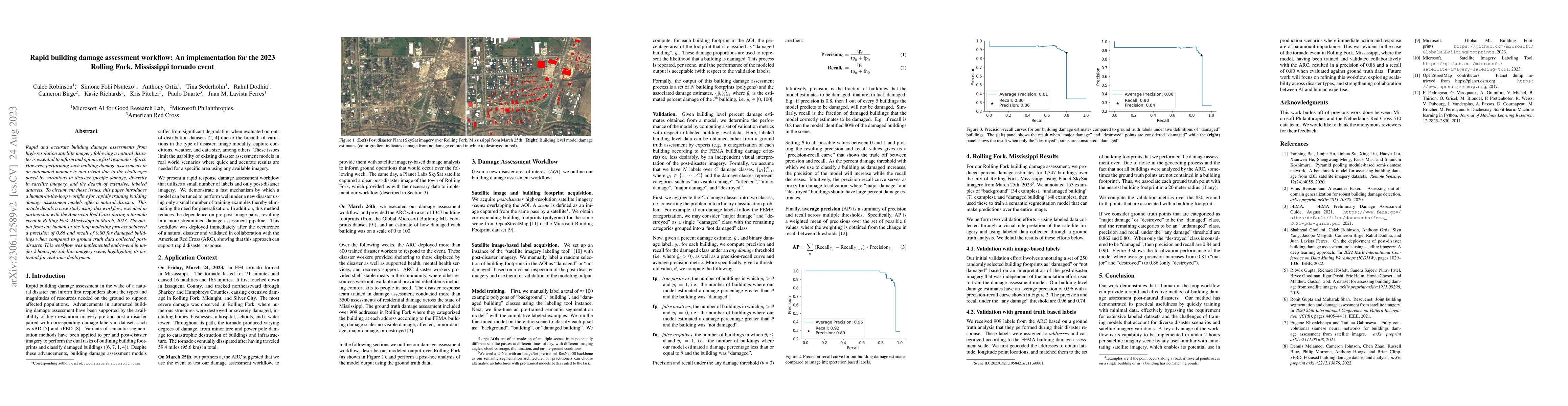
Rapid and accurate building damage assessments from high-resolution satellite imagery following a natural disaster is essential to inform and optimize first responder efforts. However, performing su...
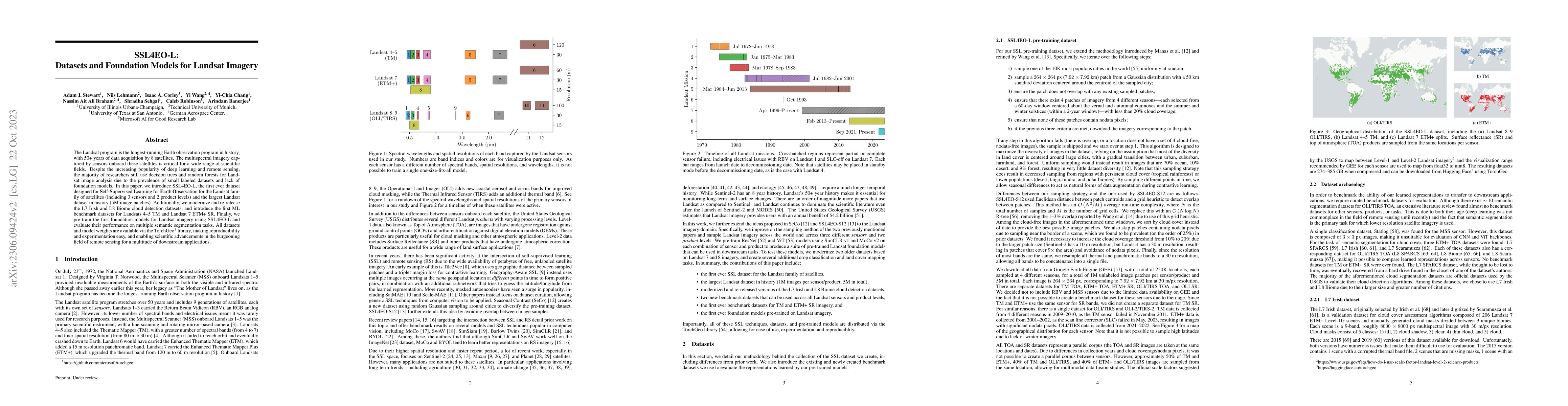
The Landsat program is the longest-running Earth observation program in history, with 50+ years of data acquisition by 8 satellites. The multispectral imagery captured by sensors onboard these satel...
GitHub is the world's largest platform for collaborative software development, with over 100 million users. GitHub is also used extensively for open data collaboration, hosting more than 800 million...
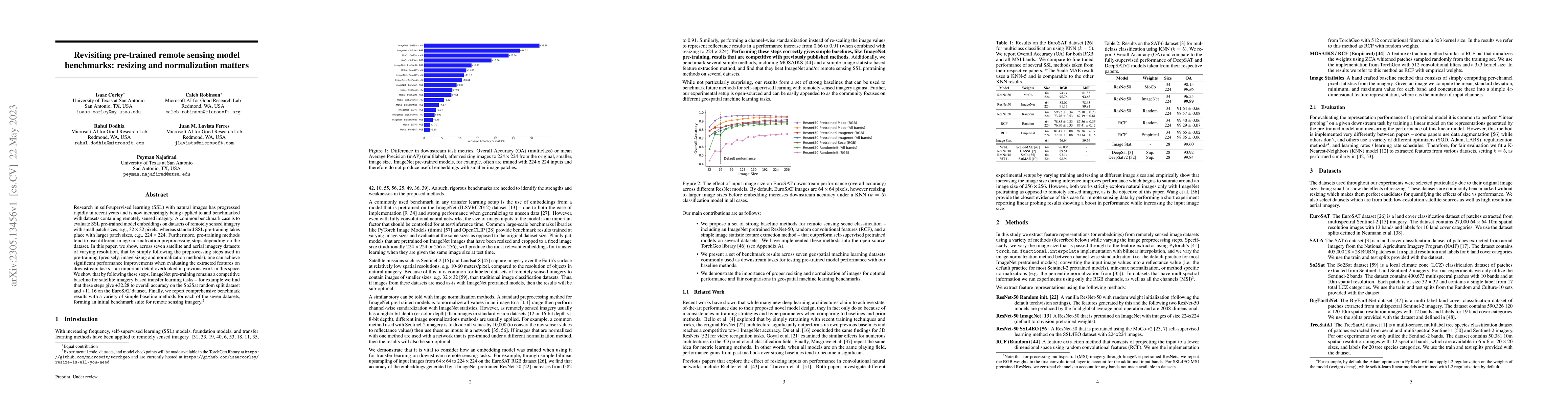
Research in self-supervised learning (SSL) with natural images has progressed rapidly in recent years and is now increasingly being applied to and benchmarked with datasets containing remotely sense...
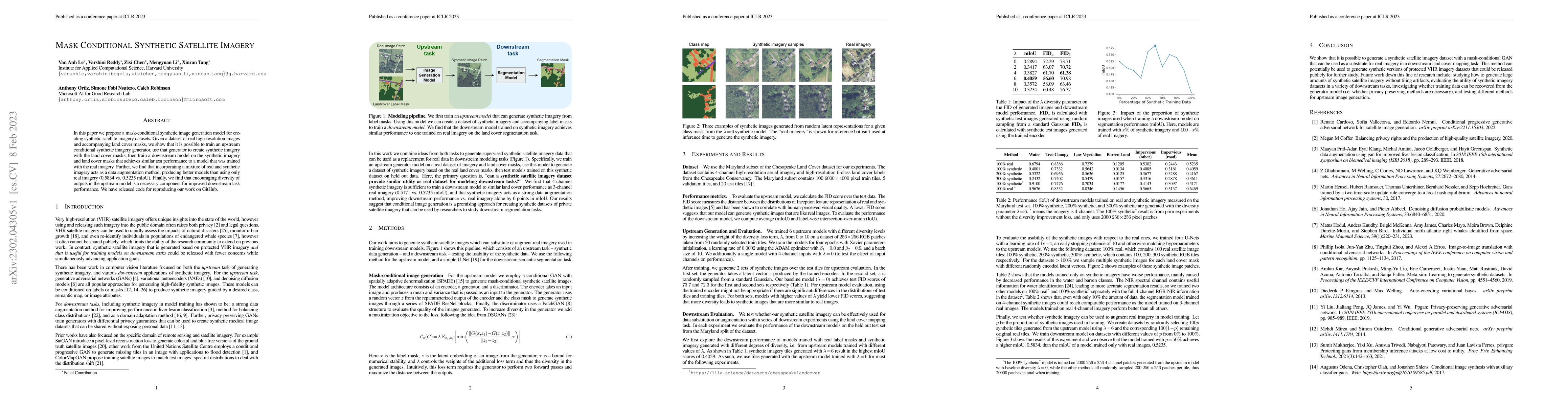
In this paper we propose a mask-conditional synthetic image generation model for creating synthetic satellite imagery datasets. Given a dataset of real high-resolution images and accompanying land c...
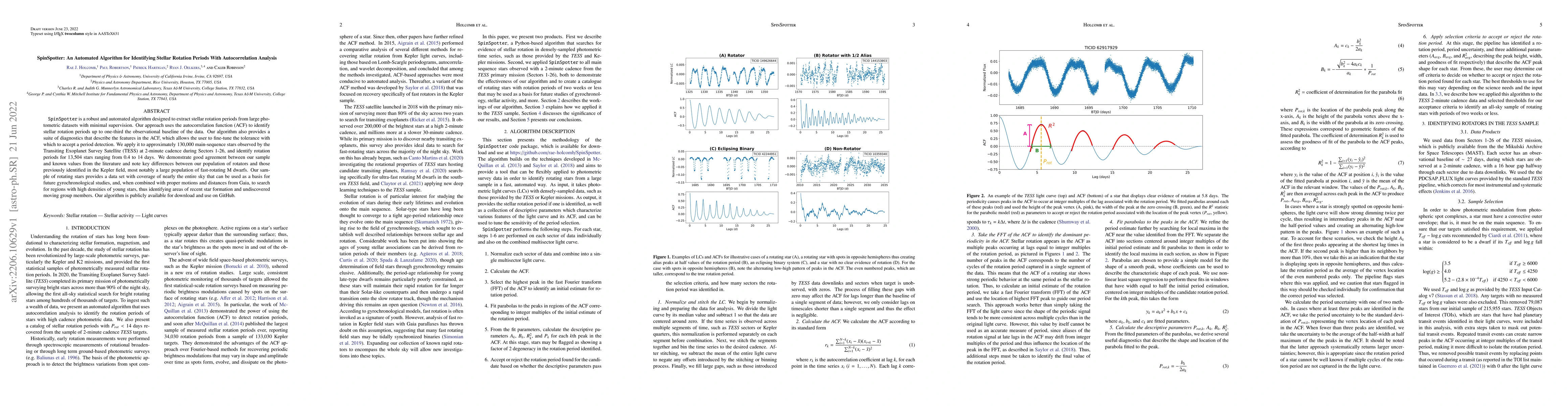
Spinspotter is a robust and automated algorithm designed to extract stellar rotation periods from large photometric datasets with minimal supervision. Our approach uses the autocorrelation function ...
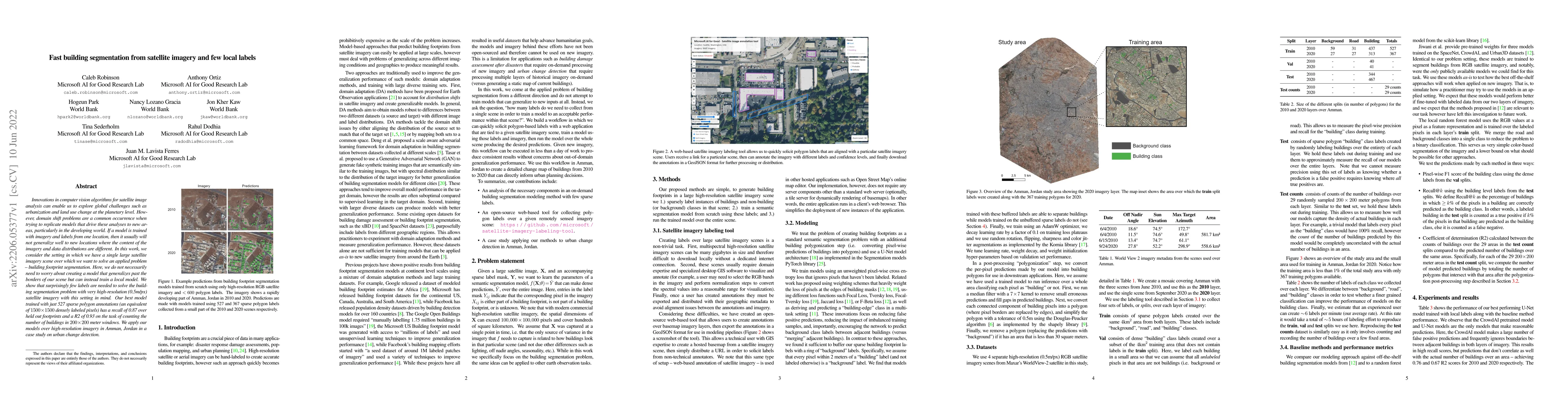
Innovations in computer vision algorithms for satellite image analysis can enable us to explore global challenges such as urbanization and land use change at the planetary level. However, domain shi...
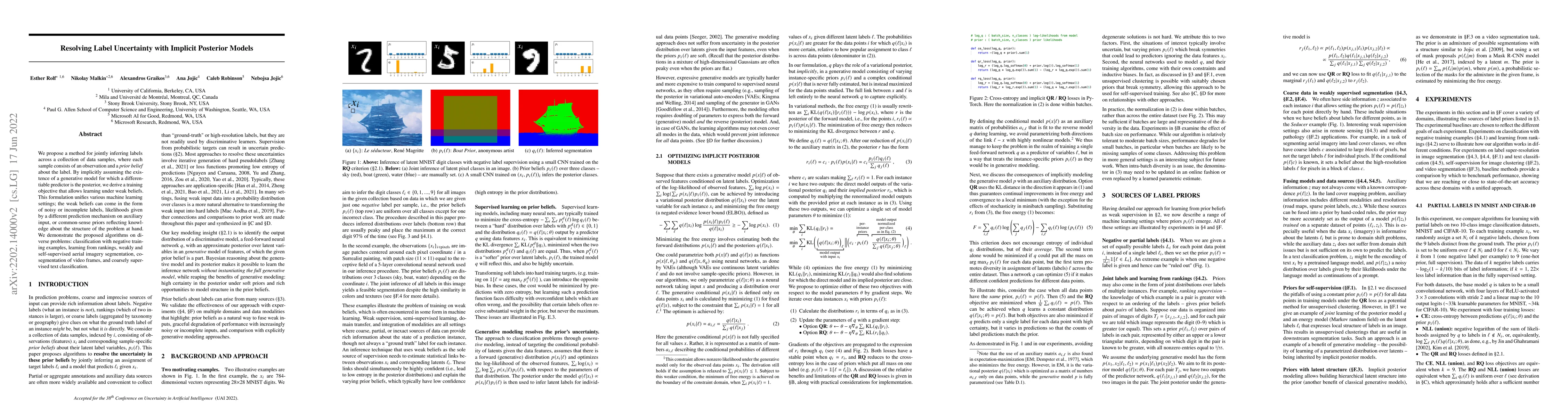
We propose a method for jointly inferring labels across a collection of data samples, where each sample consists of an observation and a prior belief about the label. By implicitly assuming the exis...

Rapid development of renewable energy sources, particularly solar photovoltaics (PV), is critical to mitigate climate change. As a result, India has set ambitious goals to install 500 gigawatts of s...
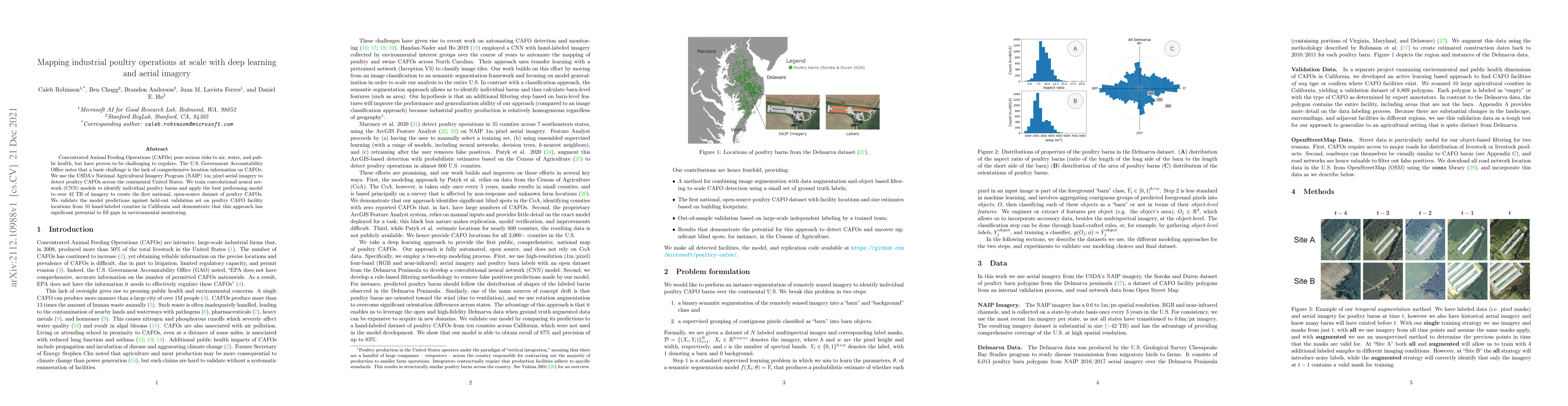
Concentrated Animal Feeding Operations (CAFOs) pose serious risks to air, water, and public health, but have proven to be challenging to regulate. The U.S. Government Accountability Office notes tha...
Remotely sensed geospatial data are critical for applications including precision agriculture, urban planning, disaster monitoring and response, and climate change research, among others. Deep learn...
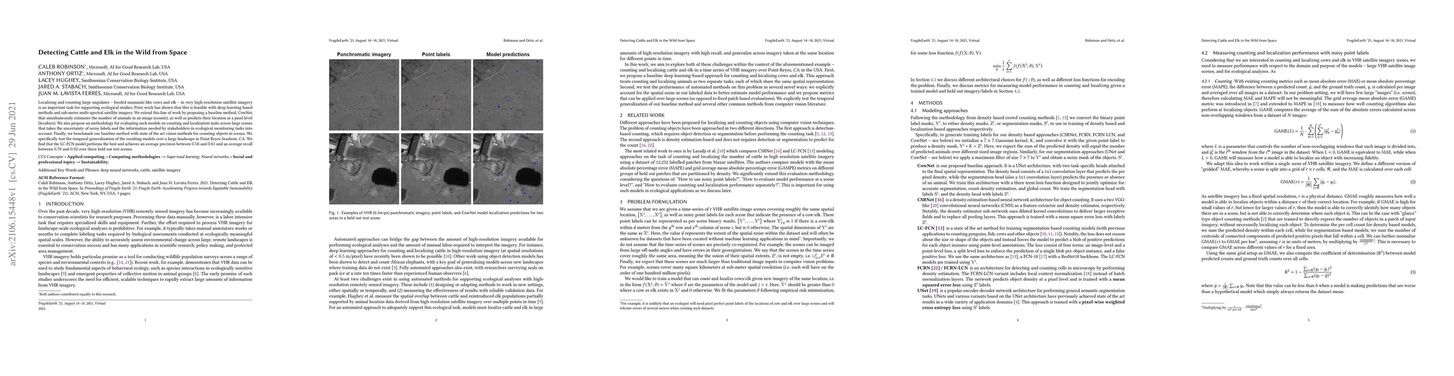
Localizing and counting large ungulates -- hoofed mammals like cows and elk -- in very high-resolution satellite imagery is an important task for supporting ecological studies. Prior work has shown ...
AI for good (AI4G) projects involve developing and applying artificial intelligence (AI) based solutions to further goals in areas such as sustainability, health, humanitarian aid, and social justic...
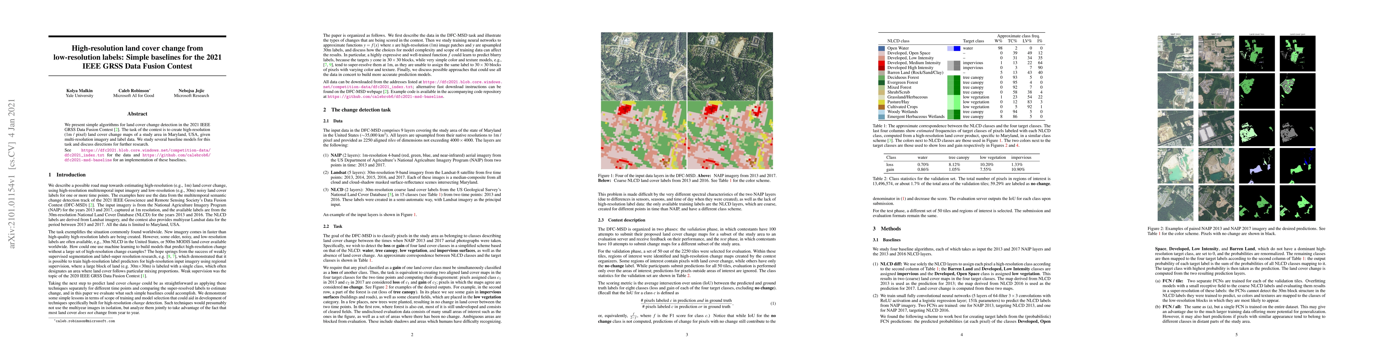
We present simple algorithms for land cover change detection in the 2021 IEEE GRSS Data Fusion Contest. The task of the contest is to create high-resolution (1m / pixel) land cover change maps of a ...
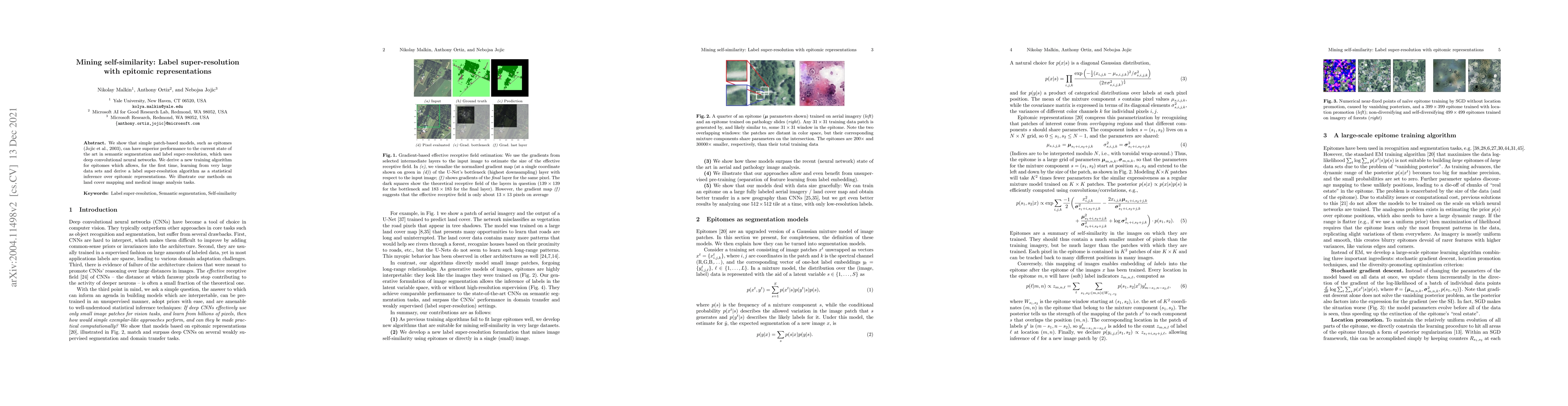
We show that simple patch-based models, such as epitomes, can have superior performance to the current state of the art in semantic segmentation and label super-resolution, which uses deep convoluti...
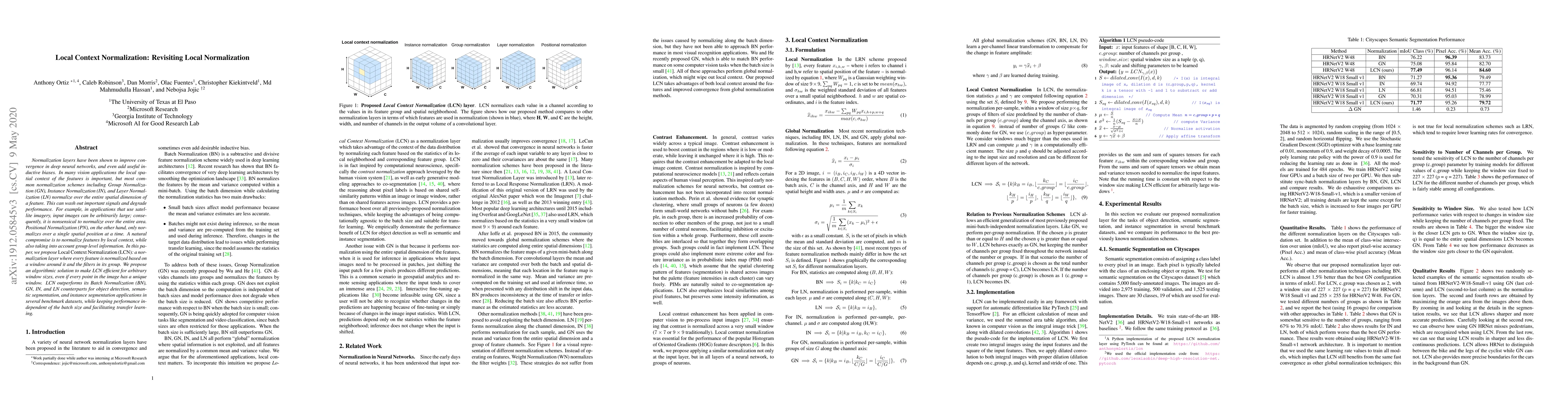
Normalization layers have been shown to improve convergence in deep neural networks, and even add useful inductive biases. In many vision applications the local spatial context of the features is im...
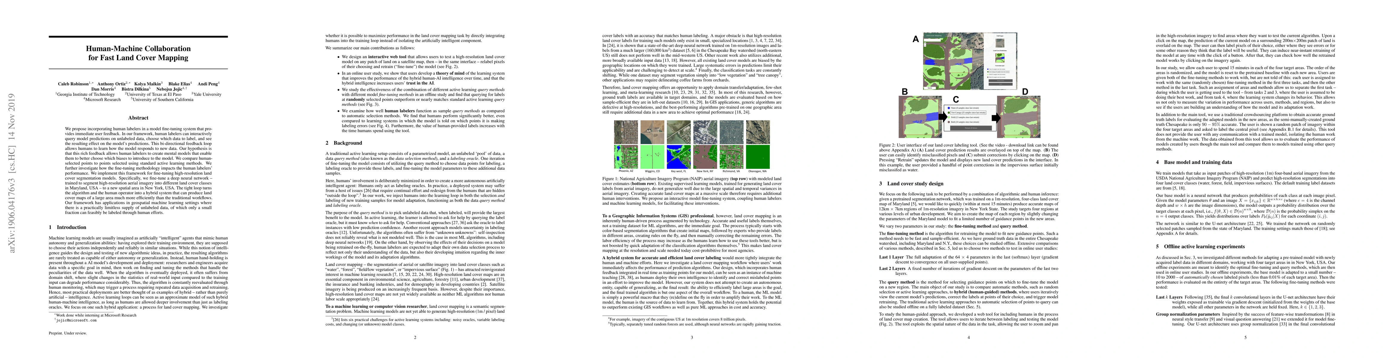
We propose incorporating human labelers in a model fine-tuning system that provides immediate user feedback. In our framework, human labelers can interactively query model predictions on unlabeled d...
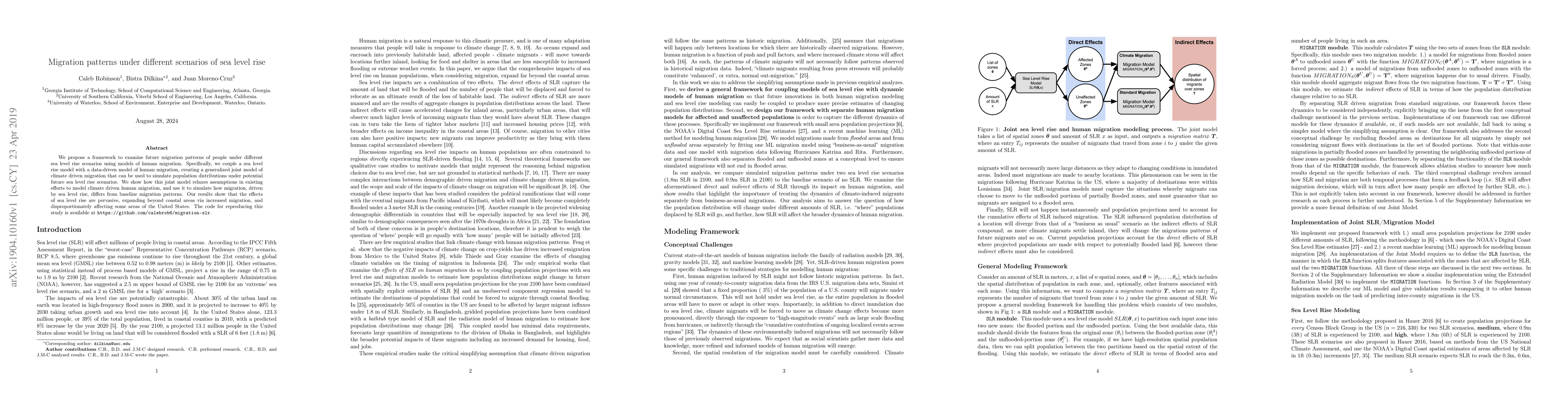
We propose a framework to examine future migration patterns of people under different sea level rise scenarios using models of human migration. Specifically, we couple a sea level rise model with a ...
Crop field boundaries are foundational datasets for agricultural monitoring and assessments but are expensive to collect manually. Machine learning (ML) methods for automatically extracting field boun...
Approximately 20% of Africa's population suffered from undernourishment, and 868 million people experienced moderate to severe food insecurity in 2022. Land-use and land-cover maps provide crucial ins...
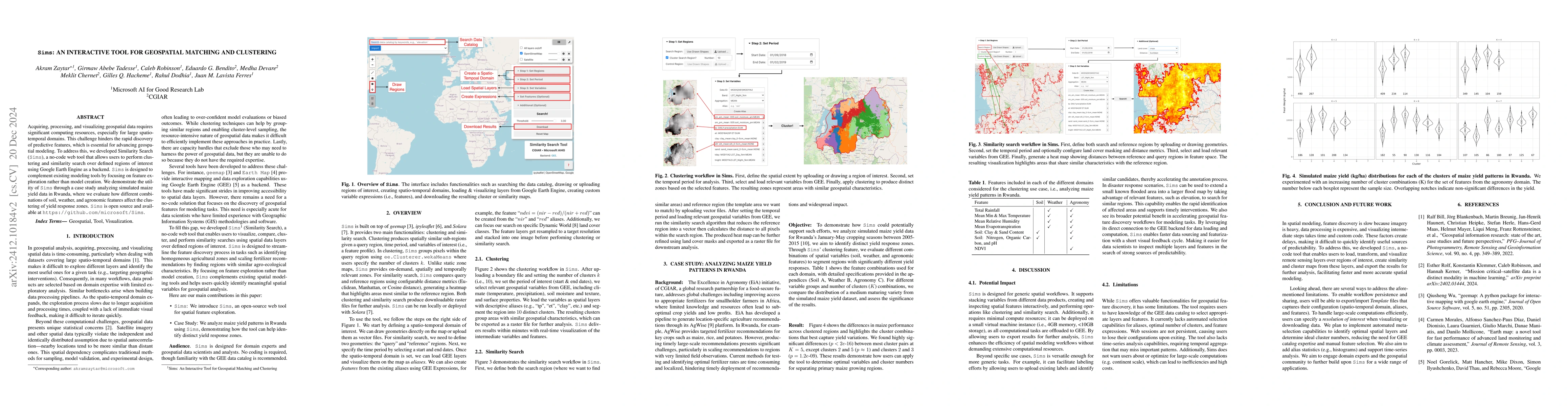
Acquiring, processing, and visualizing geospatial data requires significant computing resources, especially for large spatio-temporal domains. This challenge hinders the rapid discovery of predictive ...
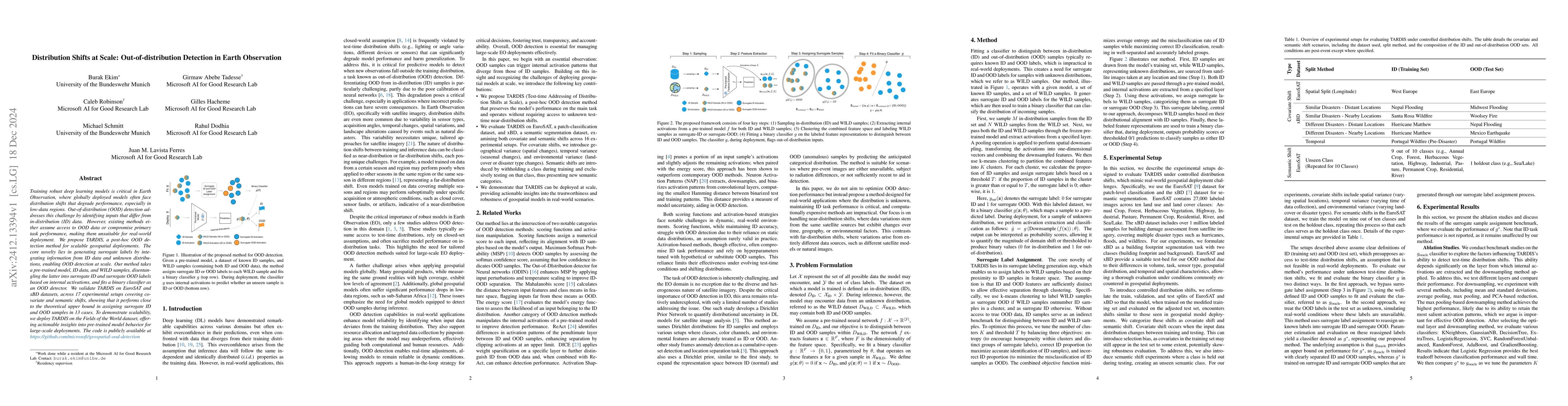
Training robust deep learning models is critical in Earth Observation, where globally deployed models often face distribution shifts that degrade performance, especially in low-data regions. Out-of-di...
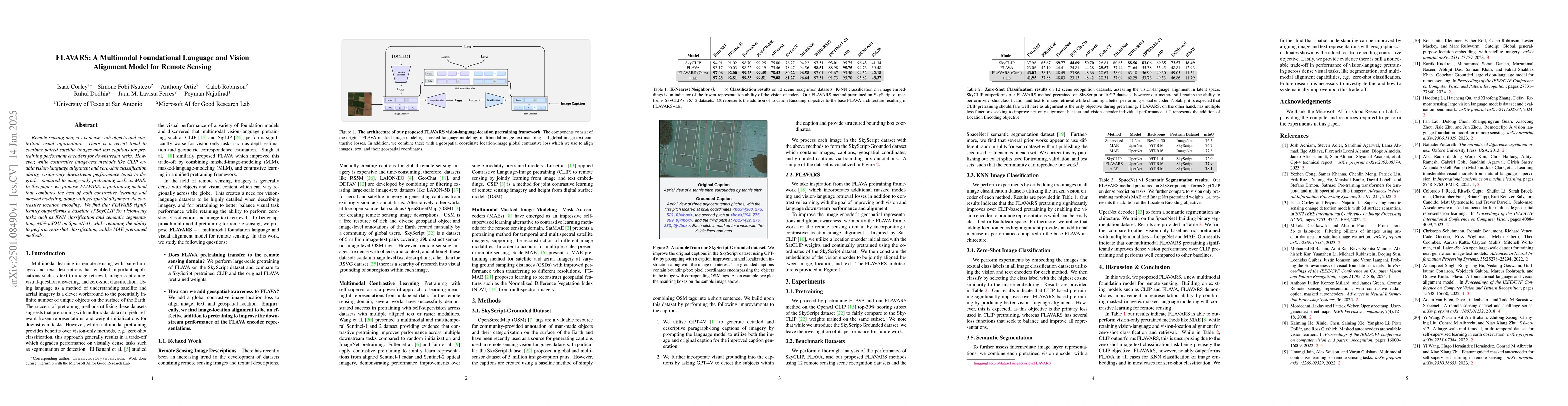
Remote sensing imagery is dense with objects and contextual visual information. There is a recent trend to combine paired satellite images and text captions for pretraining performant encoders for dow...
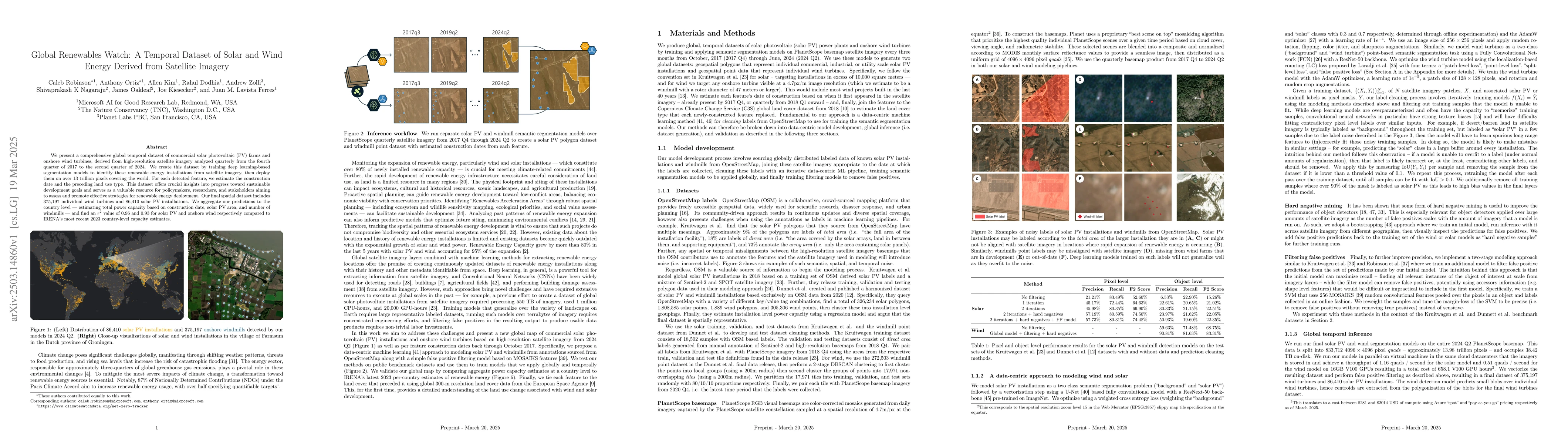
We present a comprehensive global temporal dataset of commercial solar photovoltaic (PV) farms and onshore wind turbines, derived from high-resolution satellite imagery analyzed quarterly from the fou...
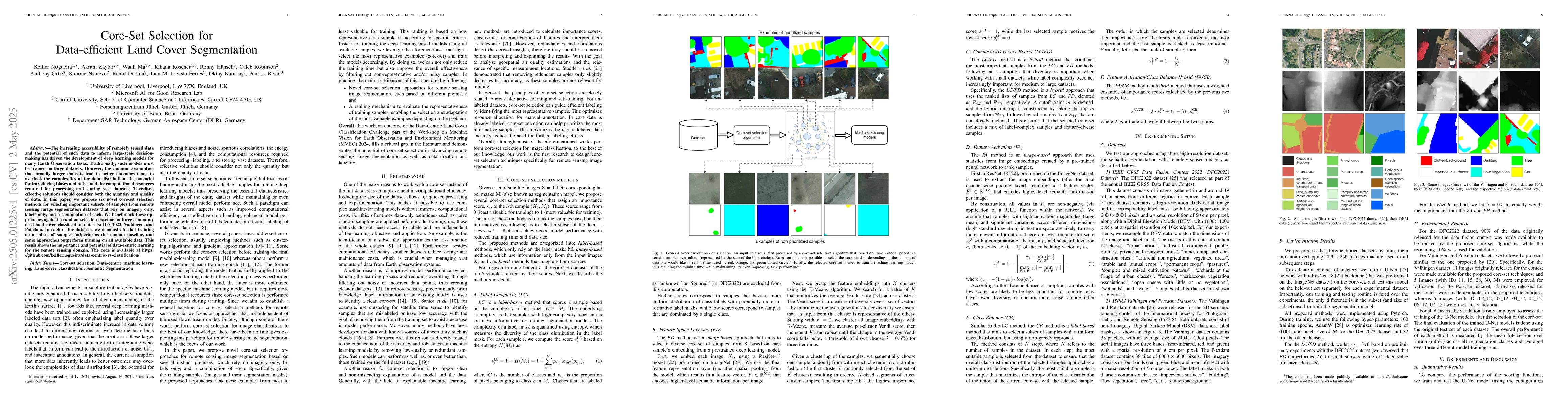
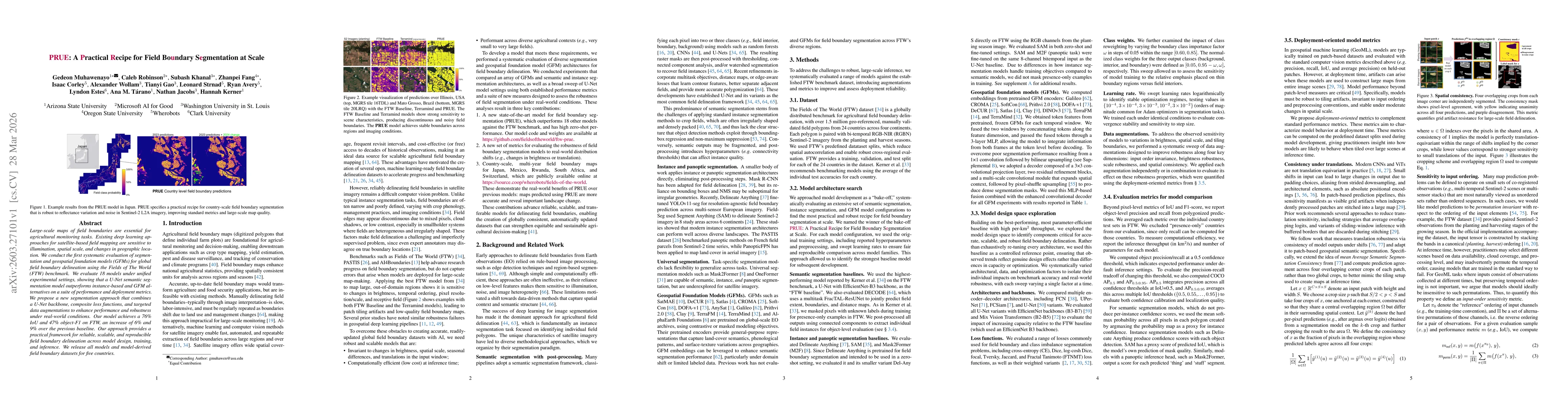
The increasing accessibility of remotely sensed data and the potential of such data to inform large-scale decision-making has driven the development of deep learning models for many Earth Observation ...
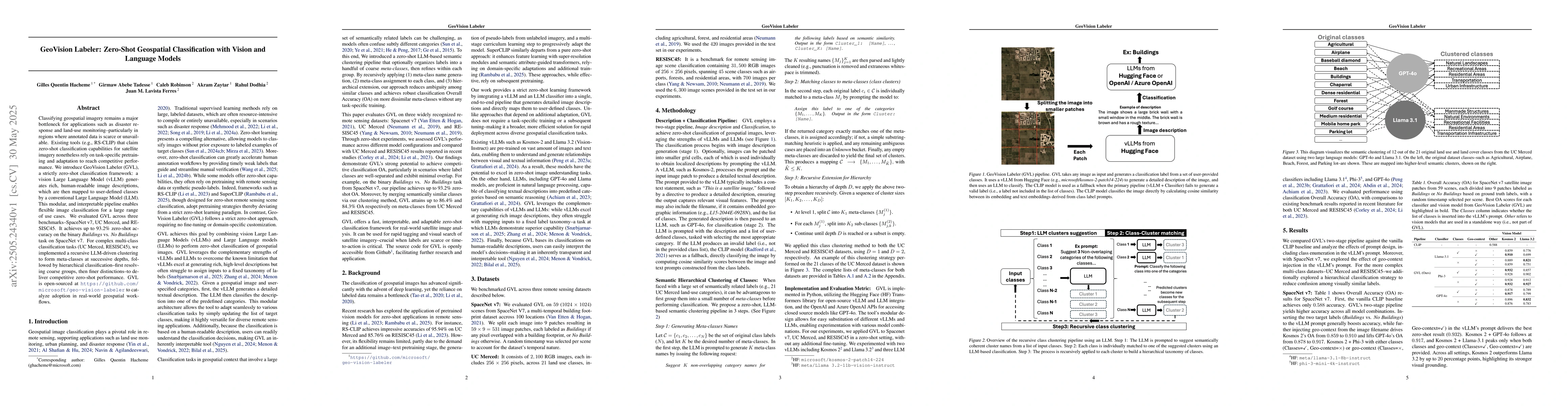
Classifying geospatial imagery remains a major bottleneck for applications such as disaster response and land-use monitoring-particularly in regions where annotated data is scarce or unavailable. Exis...
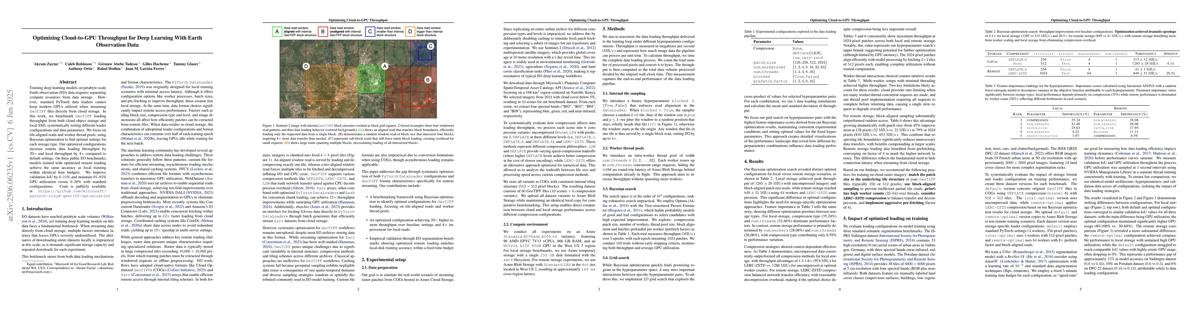
Training deep learning models on petabyte-scale Earth observation (EO) data requires separating compute resources from data storage. However, standard PyTorch data loaders cannot keep modern GPUs util...
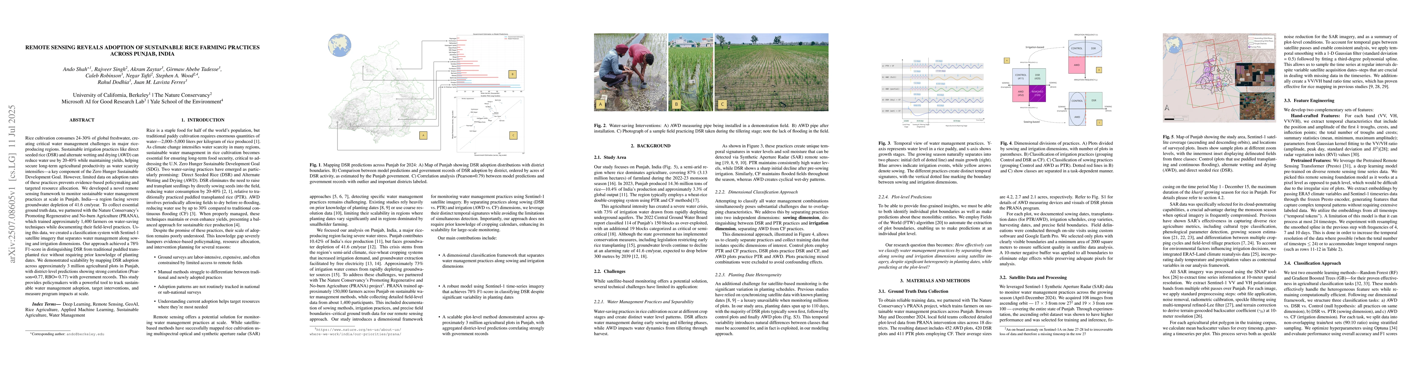
Rice cultivation consumes 24-30% of global freshwater, creating critical water management challenges in major rice-producing regions. Sustainable irrigation practices like direct seeded rice (DSR) and...
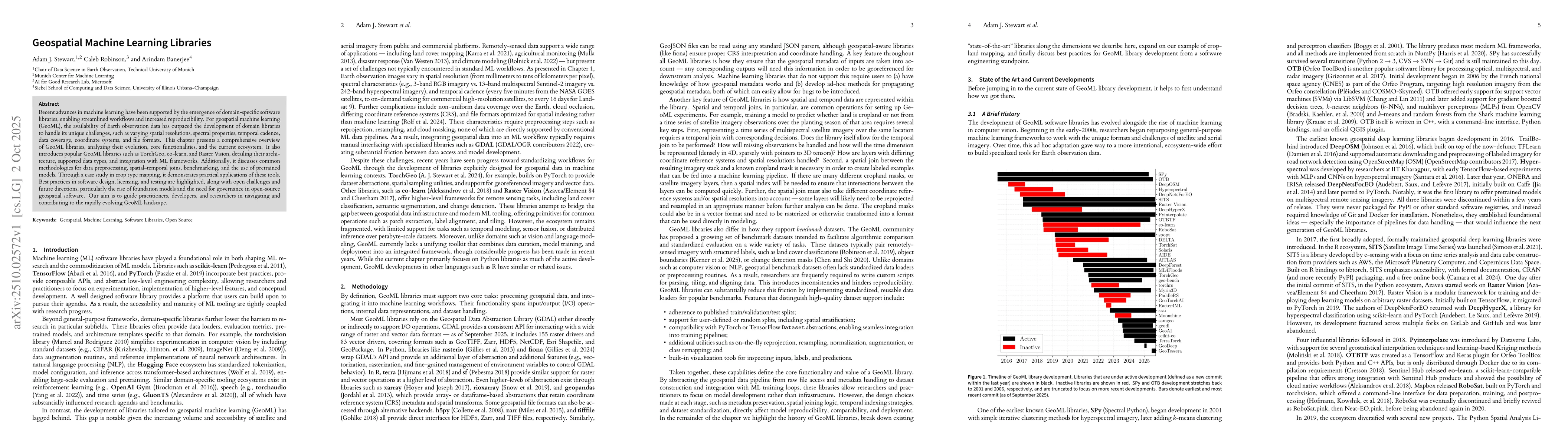
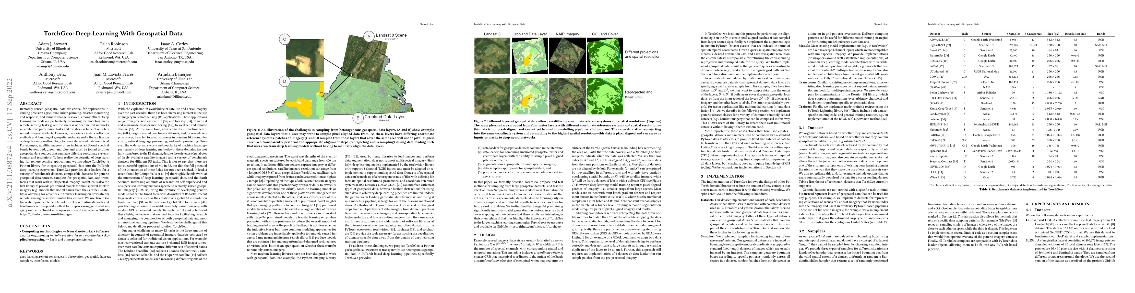
Recent advances in machine learning have been supported by the emergence of domain-specific software libraries, enabling streamlined workflows and increased reproducibility. For geospatial machine lea...
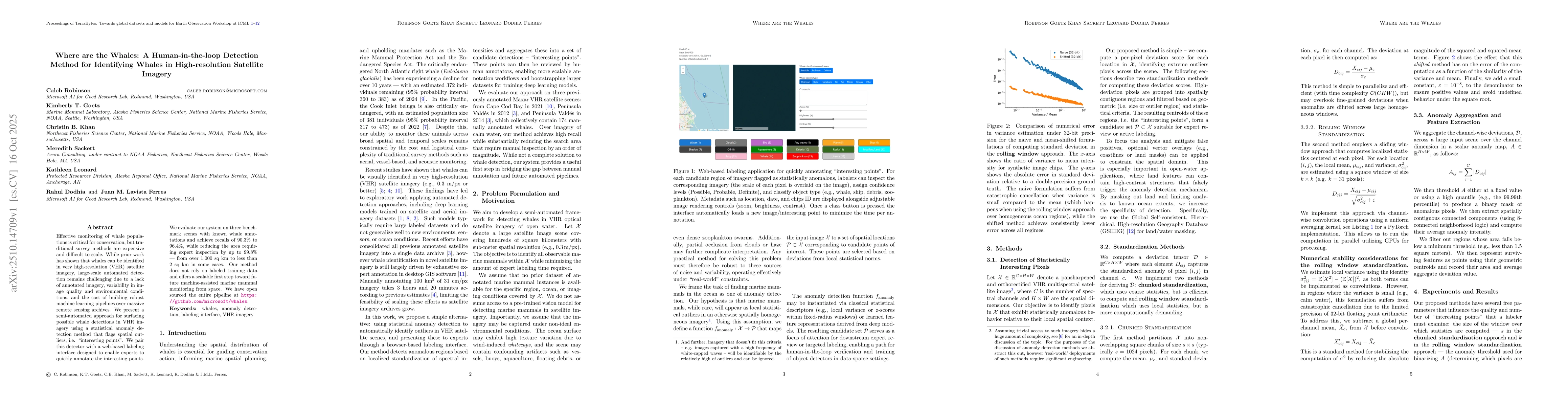
Effective monitoring of whale populations is critical for conservation, but traditional survey methods are expensive and difficult to scale. While prior work has shown that whales can be identified in...
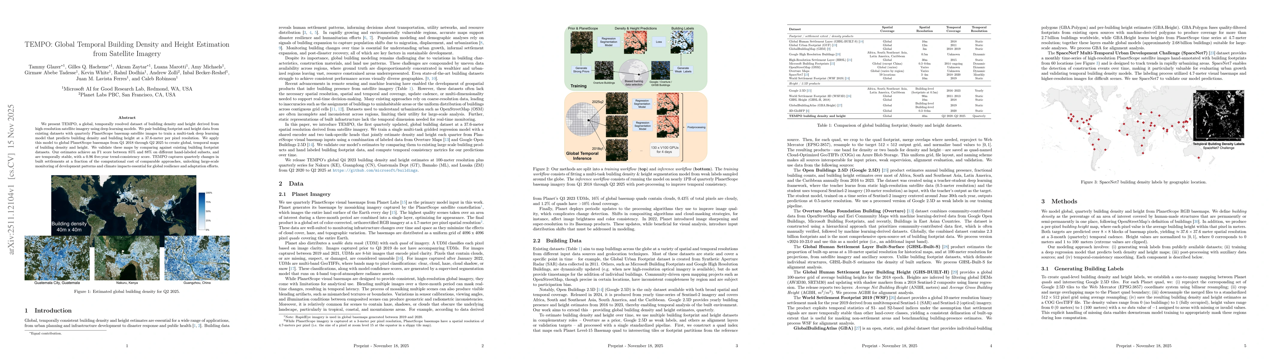
We present TEMPO, a global, temporally resolved dataset of building density and height derived from high-resolution satellite imagery using deep learning models. We pair building footprint and height ...
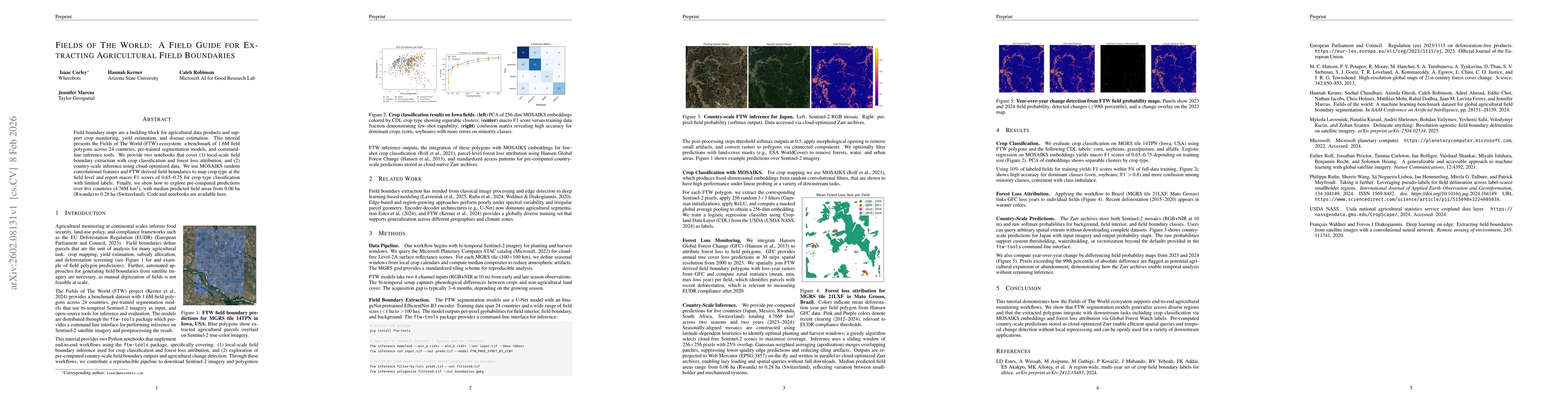
Field boundary maps are a building block for agricultural data products and support crop monitoring, yield estimation, and disease estimation. This tutorial presents the Fields of The World (FTW) ecos...
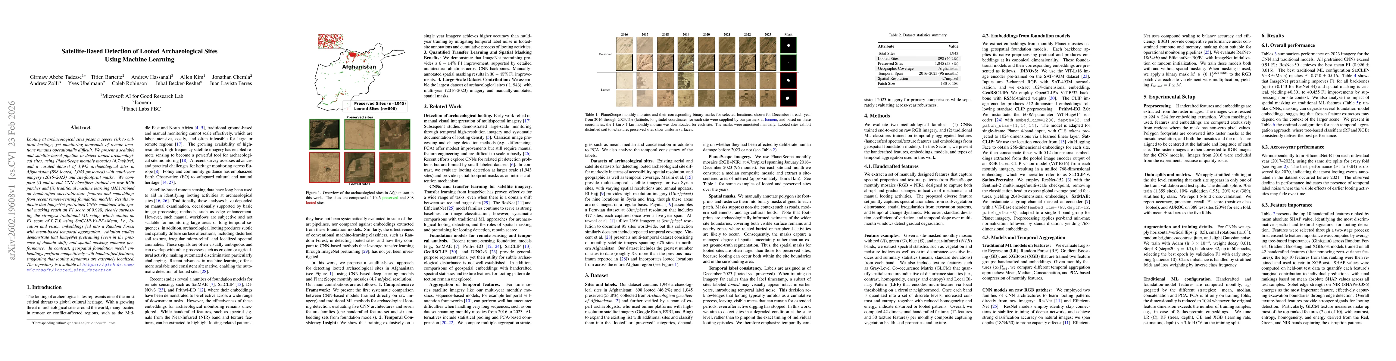
Looting at archaeological sites poses a severe risk to cultural heritage, yet monitoring thousands of remote locations remains operationally difficult. We present a scalable and satellite-based pipeli...
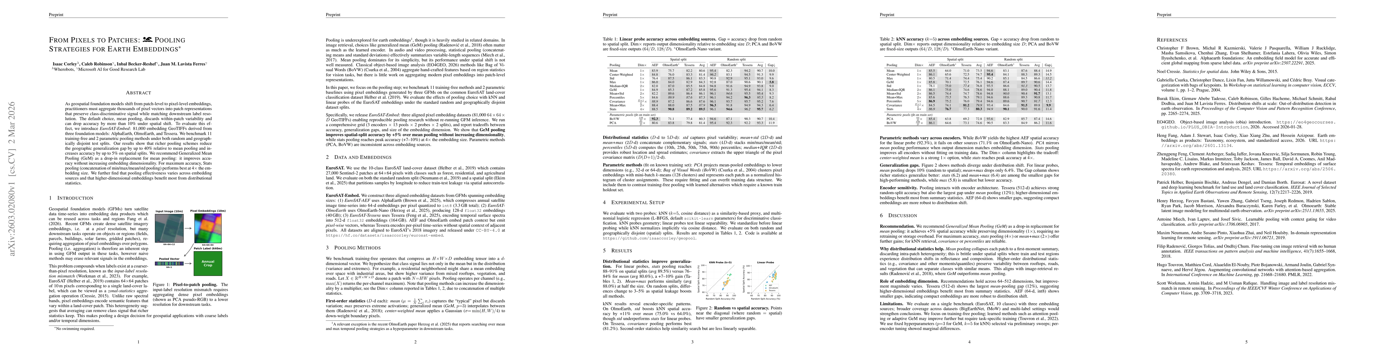
As geospatial foundation models shift from patch-level to pixel-level embeddings, practitioners must aggregate thousands of pixel vectors into patch representations that preserve class-discriminative ...
Earth observation machine learning pipelines differ fundamentally from standard computer vision workflows. Imagery is typically delivered as large, georeferenced scenes, labels may be raster masks or ...
Large-scale maps of field boundaries are essential for agricultural monitoring tasks. Existing deep learning approaches for satellite-based field mapping are sensitive to illumination, spatial scale, ...
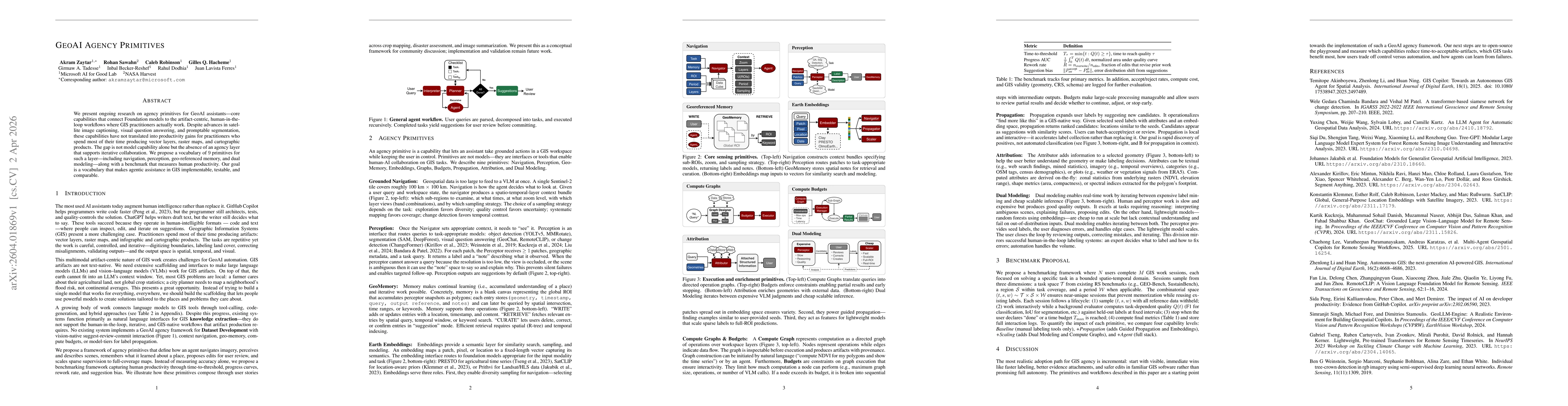
We present ongoing research on agency primitives for GeoAI assistants -- core capabilities that connect Foundation models to the artifact-centric, human-in-the-loop workflows where GIS practitioners a...
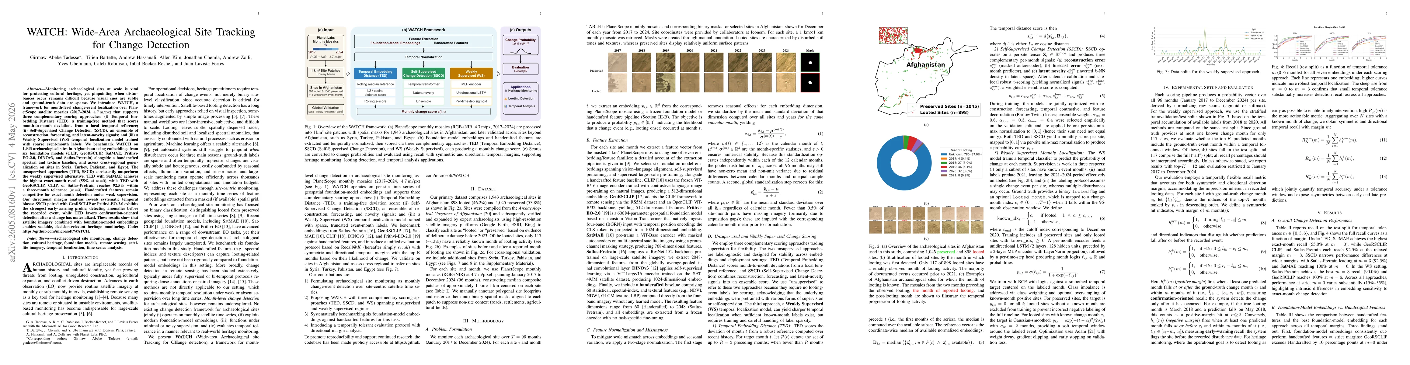
Monitoring archaeological sites at scale is vital for protecting cultural heritage, yet pinpointing when disturbances occur remains difficult because visual cues are subtle and ground-truth data are s...
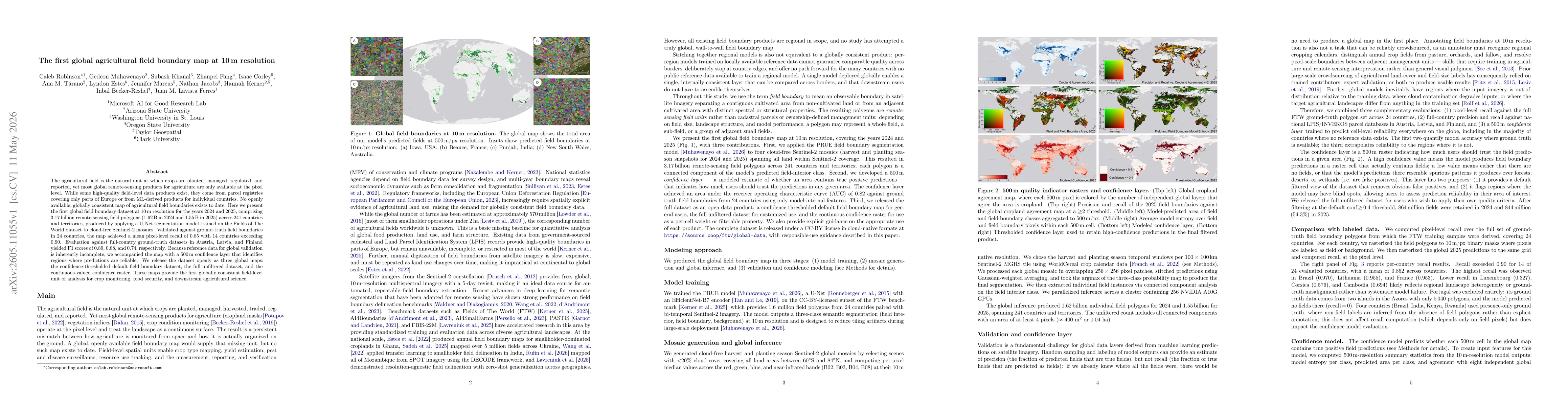
The agricultural field is the natural unit at which crops are planted, managed, regulated, and reported, yet most global remote-sensing products for agriculture are only available at the pixel level. ...
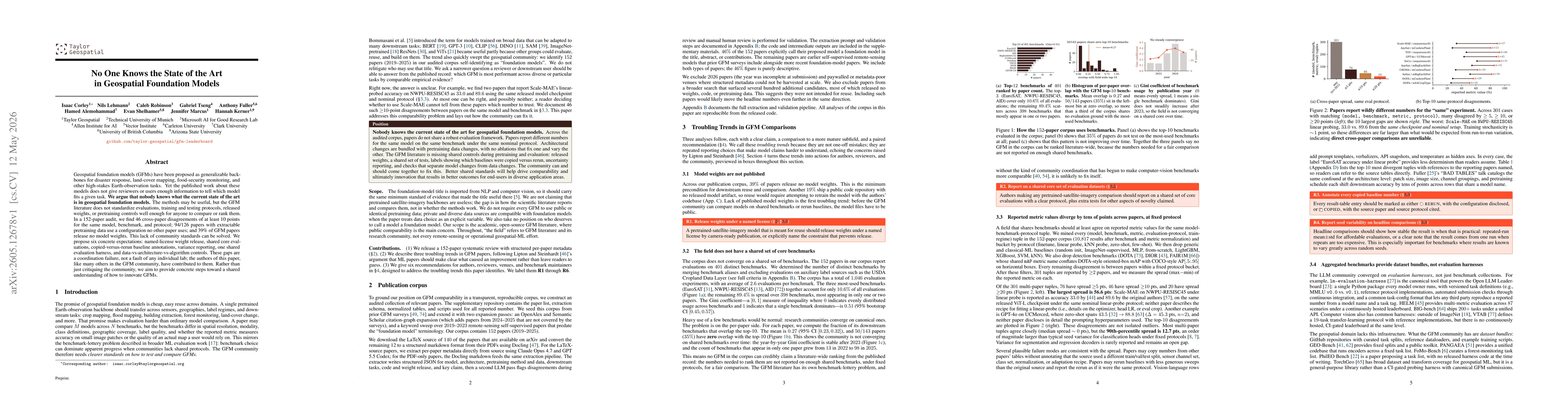
Geospatial foundation models (GFMs) have been proposed as generalizable backbones for disaster response, land-cover mapping, food-security monitoring, and other high-stakes Earth-observation tasks. Ye...
Automated aerial wildlife surveys increasingly rely on deep learning, yet standard object detectors require bounding-box annotations, reported to be up to seven times slower and three times more expen...