Quick Summary:

SatCLIP introduces a global, general-purpose location encoder that learns representations from satellite imagery, improving prediction performance across various location-dependent tasks by encoding visual similarities. It consistently outperforms alternative methods, demonstrating the value of vision-location models in geospatial data.

Summary

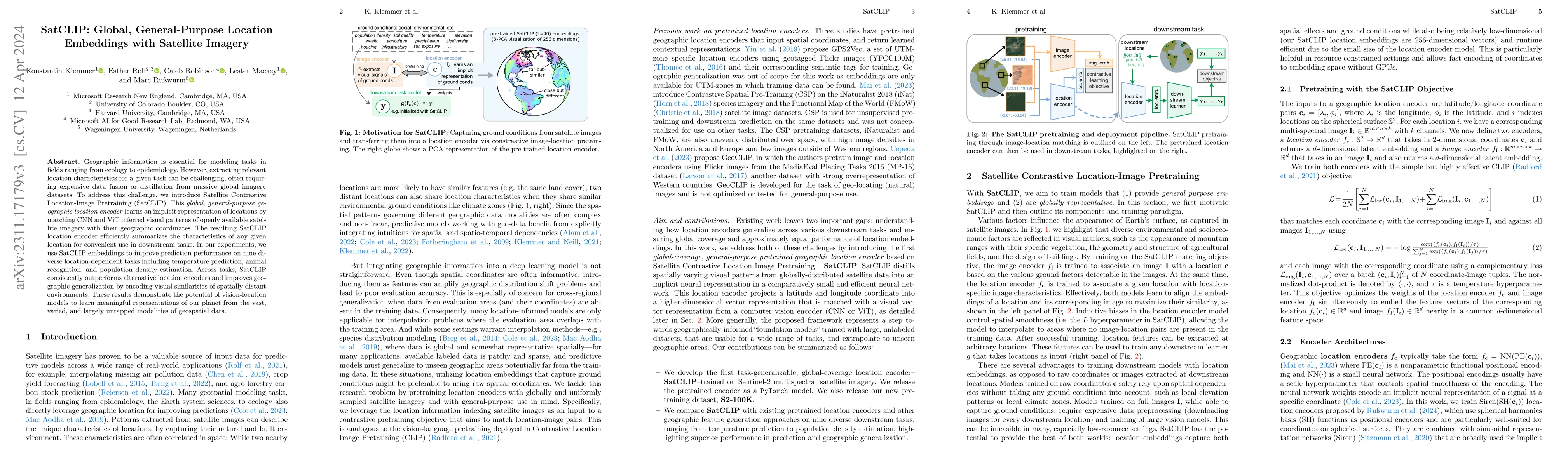
Geographic information is essential for modeling tasks in fields ranging from ecology to epidemiology. However, extracting relevant location characteristics for a given task can be challenging, often requiring expensive data fusion or distillation from massive global imagery datasets. To address this challenge, we introduce Satellite Contrastive Location-Image Pretraining (SatCLIP). This global, general-purpose geographic location encoder learns an implicit representation of locations by matching CNN and ViT inferred visual patterns of openly available satellite imagery with their geographic coordinates. The resulting SatCLIP location encoder efficiently summarizes the characteristics of any given location for convenient use in downstream tasks. In our experiments, we use SatCLIP embeddings to improve prediction performance on nine diverse location-dependent tasks including temperature prediction, animal recognition, and population density estimation. Across tasks, SatCLIP consistently outperforms alternative location encoders and improves geographic generalization by encoding visual similarities of spatially distant environments. These results demonstrate the potential of vision-location models to learn meaningful representations of our planet from the vast, varied, and largely untapped modalities of geospatial data.

AI Key Findings

Get AI-generated insights about this paper's methodology, results, and significance.

Paper Details

PDF Preview

Download PDF

Key Terms

location (0.307)
satellite (0.189)
tasks (0.187)
encoder (0.186)
visual (0.163)
characteristics (0.149)
prediction (0.142)
global (0.135)
pretraining (0.128)
contrastive (0.128)
downstream tasks (0.126)
distillation (0.123)
similarities (0.122)
convenient (0.122)
vast (0.120)
meaningful (0.120)
varied (0.119)
planet (0.116)
extracting (0.116)
modalities (0.115)

Citation Network

Current paper (gray), citations (green), references (blue)

Current Paper
Citations
References
Click to view
Title Authors Year Actions
A Survey on Remote Sensing Foundation Models: From Vision to Multimodality
Ziyue Huang, Hongxi Yan, Qiqi Zhan, Shuai Yang, Mingming Zhang, Chenkai Zhang, YiMing Lei, Zeming Liu, Qingjie Liu, Yunhong Wang
2025
View Paper
LRSCLIP: A Vision-Language Foundation Model for Aligning Remote Sensing Image with Longer Text
Weizhi Chen, Jingbo Chen, Yupeng Deng, Jiansheng Chen, Yuman Feng, Zhihao Xi, Diyou Liu, Kai Li, Yu Meng
2025
View Paper
GAIR: Improving Multimodal Geo-Foundation Model with Geo-Aligned Implicit Representations
Zeping Liu, Fan Zhang, Junfeng Jiao, Ni Lao, Gengchen Mai
2025
View Paper
MaskSDM with Shapley values to improve flexibility, robustness, and explainability in species distribution modeling
Robin Zbinden, Nina Van Tiel, Gencer Sumbul, Chiara Vanalli, B. Kellenberger, D. Tuia
2025
View Paper
Towards a Unified Copernicus Foundation Model for Earth Vision
Yi Wang, Zhitong Xiong, Chenying Liu, Adam J. Stewart, Thomas Dujardin, N. Bountos, Angelos Zavras, Franziska Gerken, Ioannis Papoutsis, Laura Leal-Taix'e, Xiao Xiang Zhu
2025
View Paper
Robustness to Geographic Distribution Shift using Location Encoders
Ruth Crasto
2025
View Paper
Integrating remote sensing with OpenStreetMap data for comprehensive scene understanding through multi-modal self-supervised learning
Lubin Bai, Xiuyuan Zhang, Haoyu Wang, Shihong Du
2025
View Paper
RANGE: Retrieval Augmented Neural Fields for Multi-Resolution Geo-Embeddings
Aayush Dhakal, S. Sastry, Subash Khanal, Adeel Ahmad, Eric Xing, Nathan Jacobs
2025
View Paper
TerraTrace - Spatio-Temporal Vegetation Signatures for Land Use Analytics
Angela Busheska, Vikram Iyer, B. Silva, Peder A. Olsen, Ranveer Chandra, V. Ranganathan
2025
View Paper
Few-shot Species Range Estimation
Christian Lange, Max Hamilton, Elijah Cole, Alexander Shepard, Samuel Heinrich, Angela Zhu, Subhransu Maji, Grant Van Horn, Oisin Mac Aodha
2025
View Paper
GAIA: A Global, Multi-modal, Multi-scale Vision-Language Dataset for Remote Sensing Image Analysis
Angelos Zavras, Dimitrios Michail, Xiao Xiang Zhu, Begum Demir, Ioannis Papoutsis
2025
View Paper
SpaCE: a spatial counterfactual explainable deep learning model for predicting out-of-hospital cardiac arrest survival outcome
Jielu Zhang, Lan Mu, Donglan Zhang, Zhuo Chen, Janani Rajbhandari-Thapa, José A. Pagán, Yan Li, Gengchen Mai, Zhongliang Zhou
2025
View Paper
Can Location Embeddings Enhance Super-Resolution of Satellite Imagery?
Daniel Panangian, Ksenia Bittner
2025
View Paper
General Geospatial Inference with a Population Dynamics Foundation Model
Mohit Agarwal, Mimi Sun, C. Kamath, Arbaaz Muslim, Prithul Sarker, Joydeep Paul, Hector Yee, M. Sieniek, Kim Jablonski, Yael Mayer, David Fork, Sheila de Guia, Jamie McPike, Adam Boulanger, T. Shekel, David Schottlander, Yao Xiao, Manjit Chakravarthy Manukonda, Yun Liu, Neslihan Bulut, Sami Abu-El-Haija, Arno Eigenwillig, Parth Kothari, Bryan Perozzi, Monica Bharel, Von Nguyen, Luke Barrington, Niv Efron, Yossi Matias, G. Corrado, Krish Eswaran, Shruthi Prabhakara, S. Shetty, Gautam Prasad
2024
View Paper
TaxaBind: A Unified Embedding Space for Ecological Applications
S. Sastry, Subash Khanal, Aayush Dhakal, Adeel Ahmad, Nathan Jacobs
2024
View Paper
Community search signatures as foundation features for human-centered geospatial modeling
Mimi Sun, C. Kamath, Mohit Agarwal, Arbaaz Muslim, Hector Yee, David Schottlander, S. Bavadekar, Niv Efron, S. Shetty, Gautam Prasad
2024
View Paper
Enhancing GeoAI and location encoding with spatial point pattern statistics: A Case Study of Terrain Feature Classification
Sizhe Wang, Wenwen Li
2024
View Paper
Combining Observational Data and Language for Species Range Estimation
Max Hamilton, Christian Lange, Elijah Cole, Alexander Shepard, Samuel Heinrich, Oisin Mac Aodha, Grant Van Horn, Subhransu Maji
2024
View Paper
Hybrid Spatial Representations for Species Distribution Modeling
Shiran Yuan, Hao Zhao
2024
View Paper
MALPOLON: A Framework for Deep Species Distribution Modeling
Théo Larcher, Lukáš Picek, Benjamin Deneu, Titouan Lorieul, Maximilien Servajean, Alexis Joly
2024
View Paper
Tackling fluffy clouds: field boundaries detection using time series of S2 and/or S1 imagery
F. Diakogiannis, Zheng-Shu Zhou, Jeff Wang, Gonzalo Mata, Dave Henry, R. Lawes, Amy Parker, P. Caccetta, Rodrigo Ibata, O. Hlinka, Jonathan Richetti, Kathryn Batchelor, Chris Herrmann, Andrew F. Toovey, John Taylor
2024
View Paper
GeoAI for Science and the Science of GeoAI
Wenwen Li, S. Arundel, Song Gao, Michael Goodchild, Yingjie Hu, Shaowen Wang, Alexander Zipf
2024
View Paper
Artificial intelligence for geoscience: Progress, challenges, and perspectives
Tianjie Zhao, Sheng Wang, Chaojun Ouyang, Min Chen, Chenying Liu, Jin Zhang, Long Yu, Fei Wang, Yong Xie, Jun Li, Fang Wang, Sabine Grunwald, Bryan M. Wong, Fan Zhang, Zhen Qian, Yongjun Xu, Chengqing Yu, Wei Han, Tao Sun, Zezhi Shao, Tangwen Qian, Zhao Chen, Jiangyuan Zeng, Huai Zhang, H. Letu, Bing Zhang, Li Wang, Lei Luo, Chong Shi, Hongjun Su, Hongsheng Zhang, Shuai Yin, Ni Huang, Wei Zhao, Nan Li, Chaolei Zheng, Yang Zhou, Changping Huang, Defeng Feng, Qingsong Xu, Yan Wu, Danfeng Hong, Zhenyu Wang, Yinyi Lin, Tangtang Zhang, Prashant Kumar, Antonio Plaza, J. Chanussot, Jiabao Zhang, Jiancheng Shi, Lizhe Wang
2024
View Paper
KidSat: satellite imagery to map childhood poverty dataset and benchmark
Makkunda Sharma, Fan Yang, Duy-Nhat Vo, Esra Suel, Swapnil Mishra, Samir Bhatt, Oliver Fiala, William Rudgard, S. Flaxman
2024
View Paper
Mapping Land Naturalness from Sentinel-2 using Deep Contextual and Geographical Priors
Burak Ekim, Michael Schmitt
2024
View Paper
TorchSpatial: A Location Encoding Framework and Benchmark for Spatial Representation Learning
Nemin Wu, Qian Cao, Zhangyu Wang, Zeping Liu, Yanlin Qi, Jielu Zhang, Joshua Ni, Xiaobai Yao, Hongxu Ma, Lan Mu, Stefano Ermon, T. Ganu, A. Nambi, Ni Lao, Gengchen Mai
2024
View Paper
(Street) Lights Will Guide You: Georeferencing Nighttime Astronaut Photography of Earth
Alex Stoken, Peter Ilhardt, Mark Lambert, Kenton Fisher
2024
View Paper
A2-MAE: A spatial-temporal-spectral unified remote sensing pre-training method based on anchor-aware masked autoencoder
Lixian Zhang, Yi Zhao, Runmin Dong, Jinxiao Zhang, Shuai Yuan, Shilei Cao, Mengxuan Chen, Juepeng Zheng, Weijia Li, Wei Liu, Wayne Zhang, Litong Feng, Haohuan Fu
2024
View Paper
SeeFar: Satellite Agnostic Multi-Resolution Dataset for Geospatial Foundation Models
James Lowman, Kelly Liu Zheng, Roydon Fraser, J. The, Mojtaba Valipour
2024
View Paper
Sat-SINR: High-Resolution Species Distribution Models Through Satellite Imagery
Johannes Dollinger, Philipp Brun, Vivien Sainte Fare Garnot, Jan Dirk Wegner
2024
View Paper
Multimodal Power Outage Prediction for Rapid Disaster Response and Resource Allocation
Alejandro Aparcedo, Christian Lopez, Abhinav Kotta, Mengjie Li
2024
View Paper
Zero Shot Classification for Change Detection in Satellite Imagery
Kürşat Kömürcü, Linas Petkevičius
2024
View Paper
Composed Image Retrieval for Remote Sensing
Bill Psomas, Ioannis Kakogeorgiou, Nikos Efthymiadis, Giorgos Tolias, Ondřej Chum, Yannis Avrithis, Konstantinos Karantzalos
2024
View Paper
Zero-shot urban function inference with street view images through prompting a pretrained vision-language model
Weiming Huang, Jing Wang, Gao Cong
2024
View Paper
MMEarth: Exploring Multi-Modal Pretext Tasks For Geospatial Representation Learning
Vishal Nedungadi, A. Kariryaa, Stefan Oehmcke, Serge J. Belongie, Christian Igel, Nico Lang
2024
View Paper
Seeing Through the Clouds: Cloud Gap Imputation with Prithvi Foundation Model
Denys Godwin, Hanxi Li, Michael Cecil, Hamed Alemohammad
2024
View Paper
GeoBind: Binding Text, Image, and Audio through Satellite Images
Aayush Dhakal, Subash Khanal, S. Sastry, Adeel Ahmad, Nathan Jacobs
2024
View Paper
WildGraph: Realistic Long-Horizon Trajectory Generation with Limited Sample Size
Ali Al-Lawati, Elsayed Eshra, Prasenjit Mitra
2024
View Paper
GeoSynth: Contextually-Aware High-Resolution Satellite Image Synthesis
S. Sastry, Subash Khanal, Aayush Dhakal, Nathan Jacobs
2024
View Paper
Application-Driven Innovation in Machine Learning
D. Rolnick, Alán Aspuru-Guzik, Sara Beery, B. Dilkina, P. Donti, Marzyeh Ghassemi, Hannah Kerner, C. Monteleoni, Esther Rolf, Milind Tambe, Adam White
2024
View Paper
Neural Plasticity-Inspired Multimodal Foundation Model for Earth Observation
Zhitong Xiong, Yi Wang, Fahong Zhang, Adam J. Stewart, Joelle Hanna, Damian Borth, Ioannis Papoutsis, B. L. Saux, G. Camps-Valls, Xiao Xiang Zhu
2024
View Paper
Major TOM: Expandable Datasets for Earth Observation
Alistair Francis, Mikolaj Czerkawski
2024
View Paper
Prospector Heads: Generalized Feature Attribution for Large Models & Data
Gautam Machiraju, Alexander Derry, Arjun Desai, Neel Guha, Amir-Hossein Karimi, James Zou, Russ B. Altman, Christopher R'e, Parag Mallick
2024
View Paper
Mind the Modality Gap: Towards a Remote Sensing Vision-Language Model via Cross-modal Alignment
Angelos Zavras, Dimitrios Michail, Begum Demir, Ioannis Papoutsis
2024
View Paper
Mission Critical - Satellite Data is a Distinct Modality in Machine Learning
Esther Rolf, Konstantin Klemmer, Caleb Robinson, Hannah Kerner
2024
View Paper
PhilEO Bench: Evaluating Geo-Spatial Foundation Models
Casper Fibaek, Luke Camilleri, Andreas Luyts, Nikolaos Dionelis, B. L. Saux
2024
View Paper
Generating Physically-Consistent Satellite Imagery for Climate Visualizations
Björn Lütjens, B. Leshchinskiy, O. Boulais, F. Chishtie, Natalia Díaz-Rodríguez, Margaux Masson-Forsythe, Ana Mata-Payerro, C. Requena-Mesa, Aruna Sankaranarayanan, A. Piña, Y. Gal, Chedy Raïssi, Alexander Lavin, Dava Newman
2021
View Paper
Neural Plasticity-Inspired Foundation Model for Observing the Earth Crossing Modalities
Zhitong Xiong, Yi Wang, Fahong Zhang, Adam J. Stewart, Joelle Hanna, Damian Borth, Ioannis Papoutsis, B. L. Saux, G. Camps-Valls, Xiao Xiang Zhu
2024
View Paper
Terra: A Multimodal Spatio-Temporal Dataset Spanning the Earth
Wei Chen, Xixuan Hao, Yuankai Wu, Yuxuan Liang
2024
View Paper
Learning to Adapt: A Representation Learning Fine-Tuning Method for Incomplete Multispectral Imagery
Darie Petcu, Inske Groenen, Dr. Arnoud Visser, Dr. Stevan Rudinac
View Paper
GIMI: A G EOGRAPHICAL G ENERALIZABLE I MAGE - TO -I MAGE S EARCH E NGINE WITH L OCATION - EXPLICIT C ONTRASTIVE E MBEDDING
Hao Li, Jiapan Wang, Balthasar Teuscher, Peng Luo, Martin Werner, Gengchen Mai, Danfeng Hong
View Paper
On the added value of sequential deep learning for upscaling of evapotranspiration
Basil Kraft, Jacob A. Nelson, Sophia Walther, Fabian Gans, Ulrich Weber, G. Duveiller, M. Reichstein, Weijie Zhang, Marc Rußwurm, D. Tuia, Marco Körner, Zayd Mahmoud Hamdi, Martin Jung
View Paper
A J OINT S PACE -T IME E NCODER FOR G EOGRAPHIC T IME -S ERIES D ATA
View Paper
AI-POWERED SCHOOL MAPPING AND CONNECTIVITY STATUS PREDICTION USING E ARTH O BSERVATION
Kelsey Doerksen, Isabelle Tingzon, Casper Fibaek, Rochelle Schneider, Do-Hyung Kim
View Paper

Comments (0)

This website uses cookies to ensure you get the best experience. Learn more