ArxivLens

Publication

Published: May 11, 2026
Categories: cs.CV, cs.LG

Metrics

Source: ArXiv

AI Quick Summary

This paper presents the first global 10 m resolution map of agricultural field boundaries for 2024–2025, producing 3.17 billion field polygons across 241 countries using a U‑Net model trained on the Fields of The World dataset and Sentinel-2 data. It includes a 500 m confidence layer for reliability, validates well against multiple country datasets, and releases three open global maps to enable consistent field-level analysis for crop monitoring and food security.

Quick Answers

What methodology did the authors use?

The study trains a U-Net segmentation model on the Fields of The World dataset and applies it to cloud-free Sentinel-2 mosaics to generate global field boundary polygons at 10m resolution for 2024 and 2025. Polygons are rasterized to a 10m grid, and a 500m confidence layer accompanies predictions. Validation uses ground-truth boundaries across 24 countries and full-country datasets in Austria,... More in Methodology →

What are the key results?

Mean pixel-level recall on 24-country validation is 0.85, with 14 countries above 0.90; F1 scores in Austria, Latvia, and Finland are 0.89, 0.88, and 0.74 respectively on full-country landscapes. — The global map comprises 3.17 billion field polygons across 241 countries, demonstrating large-scale field-level delineation at 10m resolution. More in Key Results →

Why is this work significant?

First openly available, globally consistent 10m field boundary map enabling field-level analysis for crop monitoring, food security, and downstream agricultural science, bridging the mismatch between pixel-level remote sensing products and ground-identified field units. More in Significance →

What are the main limitations?

Global validation data are inherently incomplete, leading to uncertainty in overall accuracy estimates. — Performance varies by country (e.g., Finland 0.74 F1) due to differences in training data and land-use patterns. More in Limitations →

Paper Preview

Abstract

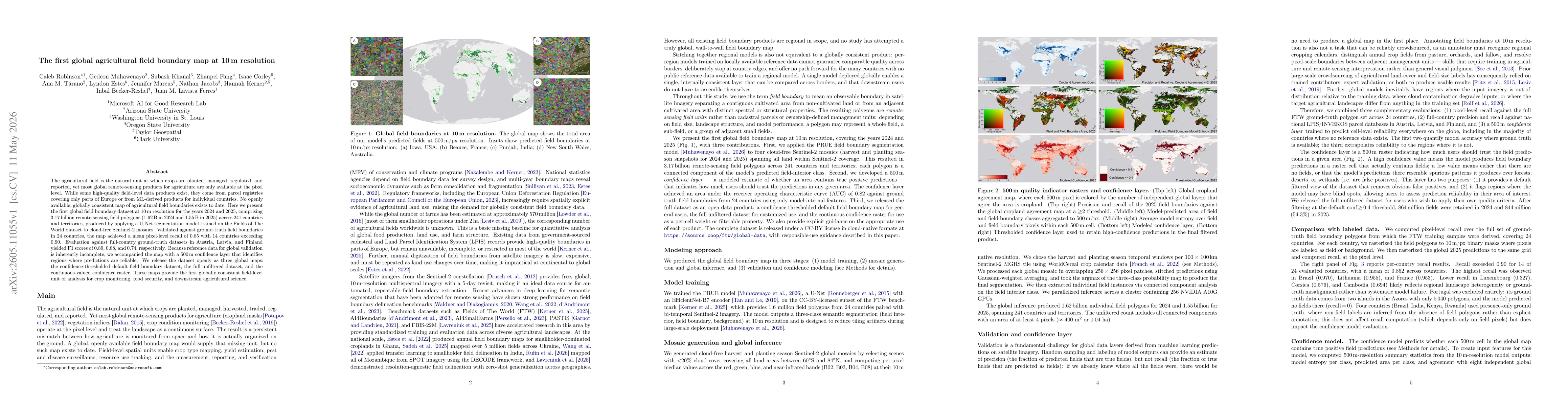
The agricultural field is the natural unit at which crops are planted, managed, regulated, and reported, yet most global remote-sensing products for agriculture are only available at the pixel level. While some high-quality field-level data products exist, they come from parcel registries covering only parts of Europe or from ML-derived products for individual countries. No openly available, globally consistent map of agricultural field boundaries exists to date. Here we present the first global field boundary dataset at 10\,m resolution for the years 2024 and 2025, comprising 3.17 billion remote-sensing field polygons (1.62 B in 2024 and 1.55 B in 2025) across 241 countries and territories, produced by applying a U-Net segmentation model trained on the Fields of The World dataset to cloud-free Sentinel-2 mosaics. Validated against ground-truth field boundaries in 24 countries, the map achieved a mean pixel-level recall of 0.85 with 14 countries exceeding 0.90. Evaluation against full-country ground-truth datasets in Austria, Latvia, and Finland yielded F1 scores of 0.89, 0.88, and 0.74, respectively. Because reference data for global validation is inherently incomplete, we accompanied the map with a 500 m confidence layer that identifies regions where predictions are reliable. We release the dataset openly as three global maps: the confidence-thresholded default field boundary dataset, the full unfiltered dataset, and the continuous-valued confidence raster. These maps provide the first globally consistent field-level unit of analysis for crop monitoring, food security, and downstream agricultural science.

Key Findings, in focus

Seven facets of this paper, analysed and brought into focus by AI.

AI-generated · verify against source Generated May 13, 2026
In focus · one-line synthesis

First openly available, globally consistent 10m field boundary map enabling field-level analysis for crop monitoring, food security, and downstream agricultural science, bridging the mismatch between pixel-level remote sensing products and ground-identified field units.

01
MethodologyHow they did it

The study trains a U-Net segmentation model on the Fields of The World dataset and applies it to cloud-free Sentinel-2 mosaics to generate global field boundary polygons at 10m resolution for 2024 and 2025. Polygons are rasterized to a 10m grid, and a 500m confidence layer accompanies predictions. Validation uses ground-truth boundaries across 24 countries and full-country datasets in Austria, Latvia, and Finland, with pixel-level metrics derived from a PRUE-like evaluation on a filtered subset of annual crops. Confidence-thresholded outputs are provided as default, full unfiltered datasets, and a continuous confidence raster.

02
ResultsWhat they found
  • Mean pixel-level recall on 24-country validation is 0.85, with 14 countries above 0.90; F1 scores in Austria, Latvia, and Finland are 0.89, 0.88, and 0.74 respectively on full-country landscapes.
  • The global map comprises 3.17 billion field polygons across 241 countries, demonstrating large-scale field-level delineation at 10m resolution.
  • A 500m confidence layer identifies regions where predictions are reliable, addressing incomplete global reference data during validation.
03
SignificanceWhy it matters

First openly available, globally consistent 10m field boundary map enabling field-level analysis for crop monitoring, food security, and downstream agricultural science, bridging the mismatch between pixel-level remote sensing products and ground-identified field units.

04
Technical ContributionsWhat's new technically

A global 10m-resolution field boundary dataset generated by a U-Net semantic segmentation model trained on FTW data and deployed on Sentinel-2 mosaics, including a 500m confidence layer and three global map outputs (default, unfiltered, and continuous confidence).

05
NoveltyWhat sets it apart

First global, openly available field boundary map at 10m resolution covering 241 countries for 2024–2025, enabling field-level analysis at planetary scale previously unavailable in open data.

06
LimitationsWhat to be cautious about
  • Global validation data are inherently incomplete, leading to uncertainty in overall accuracy estimates.
  • Performance varies by country (e.g., Finland 0.74 F1) due to differences in training data and land-use patterns.
  • Boundary delineation for small or irregular plots may be affected by imagery quality and model generalization across geographies.
07
Future WorkWhere it goes next
  • Expand validation with additional ground-truth datasets across more regions to better quantify global accuracy.
  • Improve model generalization by incorporating more diverse training samples and temporal mosaics to handle land-use changes.
  • Enhance the confidence layer by calibrating across more tile extents and integrating uncertainty quantification into downstream applications.

Paper Details

Paper ID: 2605.11055
Categories:
cs.CV cs.LG

How to Cite This Paper

Reference manager: RIS EndNote


Discussion 0

This website uses cookies to ensure you get the best experience. Learn more