Automated Floodwater Depth Estimation Using Large Multimodal Model for Rapid Flood Mapping
Publication
Metrics
AI Quick Summary
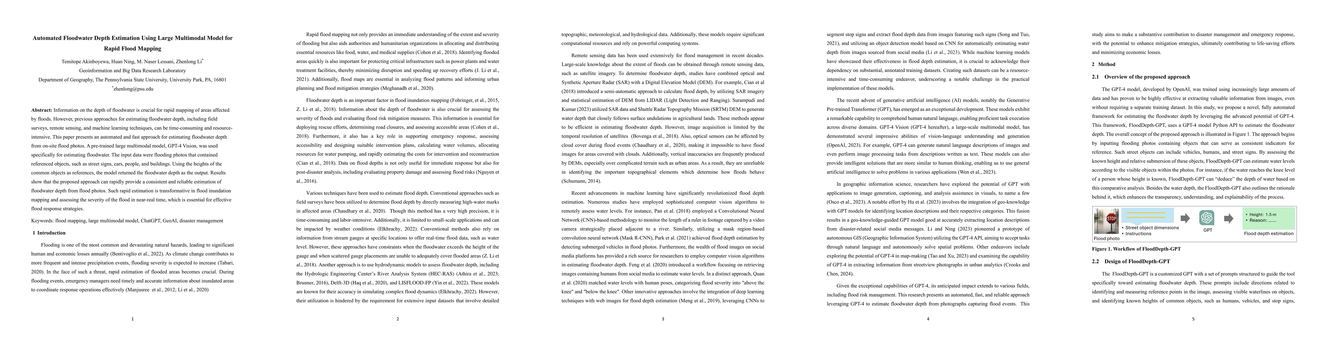
This paper introduces an automated method using a large multimodal model, GPT-4 Vision, to rapidly estimate floodwater depth from on-site photos by referencing object heights. The approach provides fast, consistent, and reliable flood depth estimations, significantly aiding in near-real-time flood mapping and response strategies.
Paper Preview
Abstract
Information on the depth of floodwater is crucial for rapid mapping of areas affected by floods. However, previous approaches for estimating floodwater depth, including field surveys, remote sensing, and machine learning techniques, can be time-consuming and resource-intensive. This paper presents an automated and fast approach for estimating floodwater depth from on-site flood photos. A pre-trained large multimodal model, GPT-4 Vision, was used specifically for estimating floodwater. The input data were flooding photos that contained referenced objects, such as street signs, cars, people, and buildings. Using the heights of the common objects as references, the model returned the floodwater depth as the output. Results show that the proposed approach can rapidly provide a consistent and reliable estimation of floodwater depth from flood photos. Such rapid estimation is transformative in flood inundation mapping and assessing the severity of the flood in near-real time, which is essential for effective flood response strategies.
AI Key Findings
Get AI-generated insights about this paper's methodology, results, significance, and more — seven facets brought into focus.
Impact
Paper Details
Authors
PDF Preview
Key Terms
Citation Network
Current paper (gray), citations (green), references (blue)
Display is limited for performance on very large graphs.
Discussion 0