ArxivLens

Publication

Published: Jan 06, 2023
Categories: cs.CV

Metrics

Source: ArXiv

AI Quick Summary

This paper proposes a deep learning method to estimate building coverage using low-resolution satellite imagery, which is more frequently updated and cost-effective. The model incorporates a multi-node quantile regression layer to enhance spatial and temporal generalization, achieving an $R^2$ of 0.968 in diverse regions, demonstrating its potential for global building coverage estimation.

Quick Answers

What methodology did the authors use?

The proposed model is based on a modified ResNet18 architecture with multi-node quantile regression, incorporating dropout layers to prevent overfitting. More in Methodology →

What are the key results?

Main finding 1: The model can accurately track temporal changes in building coverage across different regions and development levels. — Main finding 2: The proposed method outperforms existing baselines in terms of accuracy and robustness. More in Key Results →

Why is this work significant?

This research contributes to the understanding of urban development patterns and provides a novel approach for tracking building coverage changes over time. More in Significance →

What are the main limitations?

Limitation 1: The model relies on high-quality satellite imagery and may not perform well with low-resolution or noisy data. — Limitation 2: The proposed method requires large amounts of training data to achieve optimal performance. More in Limitations →

Paper Preview

Abstract

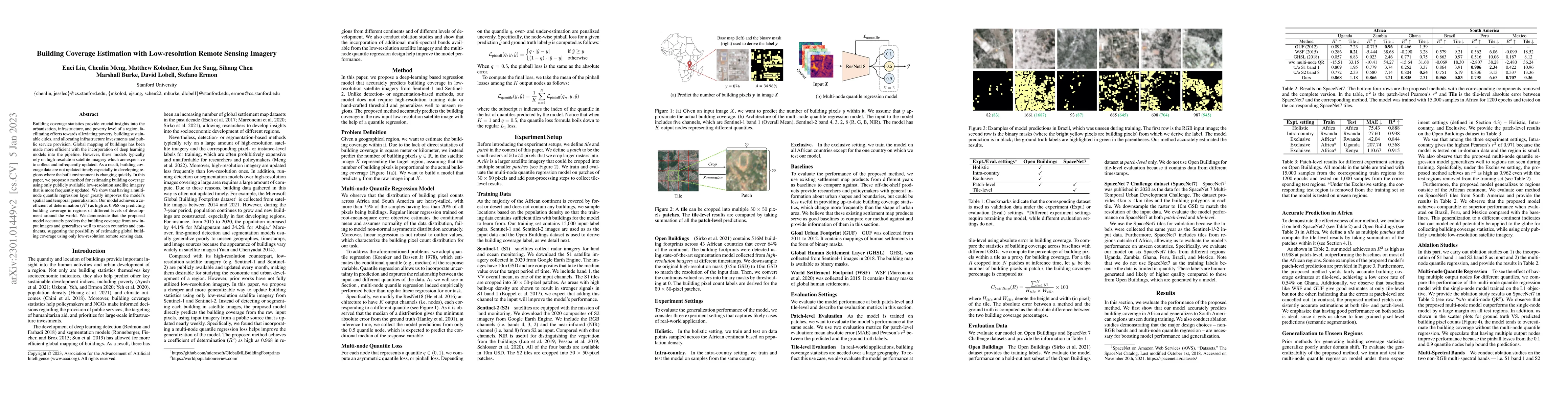
Building coverage statistics provide crucial insights into the urbanization, infrastructure, and poverty level of a region, facilitating efforts towards alleviating poverty, building sustainable cities, and allocating infrastructure investments and public service provision. Global mapping of buildings has been made more efficient with the incorporation of deep learning models into the pipeline. However, these models typically rely on high-resolution satellite imagery which are expensive to collect and infrequently updated. As a result, building coverage data are not updated timely especially in developing regions where the built environment is changing quickly. In this paper, we propose a method for estimating building coverage using only publicly available low-resolution satellite imagery that is more frequently updated. We show that having a multi-node quantile regression layer greatly improves the model's spatial and temporal generalization. Our model achieves a coefficient of determination ($R^2$) as high as 0.968 on predicting building coverage in regions of different levels of development around the world. We demonstrate that the proposed model accurately predicts the building coverage from raw input images and generalizes well to unseen countries and continents, suggesting the possibility of estimating global building coverage using only low-resolution remote sensing data.

Key Findings, in focus

Seven facets of this paper, analysed and brought into focus by AI.

AI-generated · verify against source Generated Sep 06, 2025
In focus · one-line synthesis

This research contributes to the understanding of urban development patterns and provides a novel approach for tracking building coverage changes over time.

01
MethodologyHow they did it

The proposed model is based on a modified ResNet18 architecture with multi-node quantile regression, incorporating dropout layers to prevent overfitting.

02
ResultsWhat they found
  • Main finding 1: The model can accurately track temporal changes in building coverage across different regions and development levels.
  • Main finding 2: The proposed method outperforms existing baselines in terms of accuracy and robustness.
  • Main finding 3: The model demonstrates potential for real-world applications in urban planning, infrastructure development, and disaster response.
03
SignificanceWhy it matters

This research contributes to the understanding of urban development patterns and provides a novel approach for tracking building coverage changes over time.

04
Technical ContributionsWhat's new technically

The proposed model introduces a novel approach to multi-node quantile regression, enabling accurate tracking of building coverage changes over time.

05
NoveltyWhat sets it apart

This work presents a unique combination of multi-scale and multi-resolution features, along with the incorporation of dropout layers for improved generalization.

06
LimitationsWhat to be cautious about
  • Limitation 1: The model relies on high-quality satellite imagery and may not perform well with low-resolution or noisy data.
  • Limitation 2: The proposed method requires large amounts of training data to achieve optimal performance.
07
Future WorkWhere it goes next
  • Suggested direction 1: Investigating the use of transfer learning and domain adaptation techniques for improved robustness in diverse environments.
  • Suggested direction 2: Exploring the application of multi-scale and multi-resolution models for better handling of varying spatial scales and complexities.

Impact

22
References

Paper Details

Paper ID: 2301.01449
License: http://arxiv.org/licenses/nonexclusive-distrib/1.0/
Categories:
cs.CV

How to Cite This Paper

Reference manager: RIS EndNote

Key Terms

coverage (0.308)
coverage (0.303)
building (0.278)
building (0.270)
updated (0.243)
updated (0.240)
infrastructure (0.196)
low resolution (0.189)

Citation Network

Current paper (gray), citations (green), references (blue)

Display is limited for performance on very large graphs.

Current Paper
Citations
References
Click to view


Discussion 0

This website uses cookies to ensure you get the best experience. Learn more