ArxivLens

Quick Summary:

This paper proposes a framework, Building3D, for reconstructing 3D urban building models from single-view remote sensing imagery. It introduces a Semantic Flow Field-guided DSM Estimation (SFFDE) network with modules for elevation semantic globalization and local-to-global registration, achieving superior DSM estimation and 3D model reconstruction compared to state-of-the-art methods.

DOI: 10.1109/TGRS.2023.3266477
arXiv Id: 2301.04581
Date Published: 2023-07-19
Date Updated: 2023-07-19

Categories:

Key Terms (TF-IDF):

semantic (0.248)
semantic (0.242)
building (0.238)
building (0.230)
reconstruction (0.228)
reconstruction (0.224)
registration (0.199)
multi view (0.190)
point cloud (0.190)
remote sensing (0.187)
remote (0.185)
point cloud (0.174)
view (0.163)
remote (0.161)
view (0.159)
estimation (0.152)
sensing (0.149)
estimation (0.146)
flow (0.146)
flow (0.146)
License: http://arxiv.org/licenses/nonexclusive-distrib/1.0/

Summary:

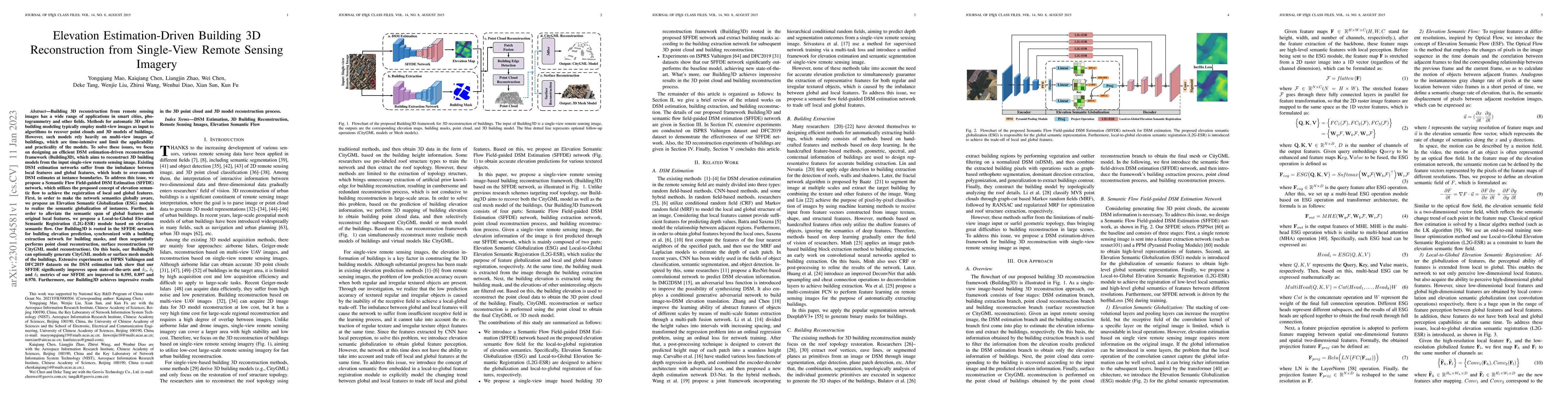
Building 3D reconstruction from remote sensing images has a wide range of applications in smart cities, photogrammetry and other fields. Methods for automatic 3D urban building modeling typically employ multi-view images as input to algorithms to recover point clouds and 3D models of buildings. However, such models rely heavily on multi-view images of buildings, which are time-intensive and limit the applicability and practicality of the models. To solve these issues, we focus on designing an efficient DSM estimation-driven reconstruction framework (Building3D), which aims to reconstruct 3D building models from the input single-view remote sensing image. First, we propose a Semantic Flow Field-guided DSM Estimation (SFFDE) network, which utilizes the proposed concept of elevation semantic flow to achieve the registration of local and global features. Specifically, in order to make the network semantics globally aware, we propose an Elevation Semantic Globalization (ESG) module to realize the semantic globalization of instances. Further, in order to alleviate the semantic span of global features and original local features, we propose a Local-to-Global Elevation Semantic Registration (L2G-ESR) module based on elevation semantic flow. Our Building3D is rooted in the SFFDE network for building elevation prediction, synchronized with a building extraction network for building masks, and then sequentially performs point cloud reconstruction, surface reconstruction (or CityGML model reconstruction). On this basis, our Building3D can optionally generate CityGML models or surface mesh models of the buildings. Extensive experiments on ISPRS Vaihingen and DFC2019 datasets on the DSM estimation task show that our SFFDE significantly improves upon state-of-the-arts. Furthermore, our Building3D achieves impressive results in the 3D point cloud and 3D model reconstruction process.

Citation & Reference Network Visualization

This graph shows how this paper is connected to other research. The current paper is shown in dark gray, papers that cite it are in green, and papers it references are in blue. You can:

Current Paper
Papers citing this work (Citations)
Papers cited by this work (References)

• Hover over any node to see the paper title

• Click a node to view that paper's details

• Drag nodes to rearrange the graph

• Use the zoom controls (bottom right) to zoom in/out

Citations and References

Title Authors Year Actions
RingMoE: Mixture-of-Modality-Experts Multi-Modal Foundation Models for Universal Remote Sensing Image Interpretation
Hanbo Bi, Yingchao Feng, Boyuan Tong, Mengyu Wang, Haichen Yu, Yongqiang Mao, Hao Chang, Wenhui Diao, Peijin Wang, Yue Yu, Hanyang Peng, Yehong Zhang, Kun Fu, Xian Sun
2025
View Paper
LOD1 3D city model from LiDAR: The impact of segmentation accuracy on quality of urban 3D modeling and morphology extraction
Fatemeh Chajaei, Hossein Bagheri
2025
View Paper
Single-Step Latent Consistency Model for Remote Sensing Image Super-Resolution
Xiaohui Sun, Jiangwei Mo, Hanlin Wu, Jie Ma
2025
View Paper
CMAB: A Multi-Attribute Building Dataset of China
Yecheng Zhang, Huimin Zhao, Ying Long
2025
View Paper
Building extraction from remote sensing images with deep learning: A survey on vision techniques
Yuan Yuan, Xiaofeng Shi, Jun-Ge Gao
2024
View Paper
Latent Diffusion, Implicit Amplification: Efficient Continuous-Scale Super-Resolution for Remote Sensing Images
Hanlin Wu, Jiangwei Mo, Xiaohui Sun, Jie Ma
2024
View Paper
HENet: A Height Estimation Network for Estimating the Height of Buildings from Single Optical Image
Yachen Wang, Huayong Tang, Yejian Zhou, Guanyong Wang
2024
View Paper
Prompt-and-Transfer: Dynamic Class-Aware Enhancement for Few-Shot Segmentation
Hanbo Bi, Yingchao Feng, Wenhui Diao, Peijin Wang, Yongqiang Mao, Kun Fu, Hongqi Wang, Xian Sun
2024
View Paper
CMAB: A First National-Scale Multi-Attribute Building Dataset in China Derived from Open Source Data and GeoAI
Yecheng Zhang, Huimin Zhao, Ying Long
2024
View Paper
SynRS3D: A Synthetic Dataset for Global 3D Semantic Understanding from Monocular Remote Sensing Imagery
Jian Song, Hongruixuan Chen, Weihao Xuan, Junshi Xia, Naoto Yokoya
2024
View Paper
Twin Deformable Point Convolutions for Point Cloud Semantic Segmentation in Remote Sensing Scenes
Yongqiang Mao, Hanbo Bi, Xuexue Li, Kaiqiang Chen, Zhirui Wang, Xian Sun, Kun Fu
2024
View Paper
SDL-MVS: View Space and Depth Deformable Learning Paradigm for Multiview Stereo Reconstruction in Remote Sensing
Yongqiang Mao, Hanbo Bi, Liangyu Xu, Kaiqiang Chen, Zhirui Wang, Xian Sun, Kun Fu
2024
View Paper
GABLE: A first fine-grained 3D building model of China on a national scale from very high resolution satellite imagery
Xian Sun, Xingliang Huang, Yongqiang Mao, Taowei Sheng, Jihao Li, Zhirui Wang, Xue Lu, Xiaoliang Ma, Deke Tang, Kaiqiang Chen
2024
View Paper
3D Building Reconstruction from Monocular Remote Sensing Images with Multi-level Supervisions
Weijia Li, Haote Yang, Zhenghao Hu, Juepeng Zheng, Gui-Song Xia, Conghui He
2024
View Paper
Enhancing Building Point Cloud Reconstruction from RGB UAV Data with Machine-Learning-Based Image Translation
E. J. Dippold, Fuan Tsai
2024
View Paper
TAFormer: A Unified Target-Aware Transformer for Video and Motion Joint Prediction in Aerial Scenes
Liangyu Xu, Wanxuan Lu, Hongfeng Yu, Yongqiang Mao, Hanbo Bi, Chenglong Liu, Xian Sun, Kun Fu
2024
View Paper
Deep-Learning-Based Automated Building Information Modeling Reconstruction Using Orthophotos with Digital Surface Models
Dejiang Wang, Quanming Jiang, Jinzheng Liu
2024
View Paper
SFTformer: A Spatial-Frequency-Temporal Correlation-Decoupling Transformer for Radar Echo Extrapolation
Liangyu Xu, Wanxuan Lu, Hongfeng Yu, Fanglong Yao, Xian Sun, Kun Fu
2024
View Paper
Reconstruction of 3D Information of Buildings from Single-View Images Based on Shadow Information
Zhixin Li, Song Ji, D. Fan, Zhen Yan, Fengyi Wang, Ren Wang
2024
View Paper
HeightFormer: A Multilevel Interaction and Image-Adaptive Classification-Regression Network for Monocular Height Estimation with Aerial Images
Zhan Chen, Yidan Zhang, Xiyu Qi, Yongqiang Mao, Xin Zhou, Lei Wang, Yunping Ge
2024
View Paper
Self-guided Few-shot Semantic Segmentation for Remote Sensing Imagery Based on Large Vision Models
Xiyu Qi, Yifan Wu, Yongqiang Mao, Wenhui Zhang, Yidan Zhang
2023
View Paper
Vehicle Detection and Attribution from a Multi-Sensor Dataset Using a Rule-Based Approach Combined with Data Fusion
Lindsey A. Bowman, Ram M. Narayanan, Timothy J. Kane, Eliza S. Bradley, Matthew S. Baran
2023
View Paper
Not Just Learning From Others but Relying on Yourself: A New Perspective on Few-Shot Segmentation in Remote Sensing
Hanbo Bi, Yingchao Feng, Zhiyuan Yan, Yongqiang Mao, Wenhui Diao, Hongqi Wang, Xian Sun
2023
View Paper
HeightFormer: A Multilevel Interaction and Image-adaptive Classification-regression Network for Monocular Height Estimation with Aerial Images
Zhan Chen, Yidan Zhang, Xiyu Qi, Yongqiang Mao, Xin Zhou, Lulu Niu, Hui Wu, Lei Wang, Yunping Ge
2023
View Paper
Light: Joint Individual Building Extraction and Height Estimation from Satellite Images Through a Unified Multitask Learning Network
Yongqiang Mao, Xian Sun, Xingliang Huang, Kaiqiang Chen
2023
View Paper
DSMF-Net: Dual Semantic Metric Learning Fusion Network for Few-Shot Aerial Image Semantic Segmentation
Xiyu Qi, Yidan Zhang, Lei Wang, Yifan Wu, Yi Xin, Zhan Chen, Yunping Ge
2025
View Paper
FRORS: An Effective Fine-Grained Retrieval Framework for Optical Remote Sensing Images
Yong-Qiang Mao, Zhizhuo Jiang, Yu Liu, Yiming Zhang, Kehan Qi, Hanbo Bi, You He
2025
View Paper
Weakly Supervised 3-D Building Reconstruction From Monocular Remote Sensing Images
Weijia Li, Zhenghao Hu, Lingxuan Meng, Jinwang Wang, Juepeng Zheng, Runmin Dong, Conghui He, Gui-Song Xia, Haohuan Fu, Dahua Lin
2024
View Paper
SIRS: Multitask Joint Learning for Remote Sensing Foreground-Entity Image–Text Retrieval
Zicong Zhu, Jian Kang, Wenhui Diao, Yingchao Feng, Junxi Li, Jing Ni
2024
View Paper
A Novel LOD Rendering Method With Multilevel Structure-Keeping Mesh Simplification and Fast Texture Alignment for Realistic 3-D Models
Yingwei Ge, Xiongwu Xiao, Bingxuan Guo, Zhenfeng Shao, Jianya Gong, Deren Li
2024
View Paper
SingleRecon: Reconstructing Building 3-D Models of LoD1 From a Single Off-Nadir Remote Sensing Image
Ruizhe Shao, Jiangjiang Wu, Jun Li, Shuang Peng, Hao Chen, C. Du
2024
View Paper

Similar Papers

3D Building Reconstruction from Monocular Remote Sensing Images with Multi-level Supervisions

Weijia Li, Haote Yang, Conghui He, Gui-Song Xia, Juepeng Zheng, Zhenghao Hu

Published: 2024-04-09

SynRS3D: A Synthetic Dataset for Global 3D Semantic Understanding from Monocular Remote Sensing Imagery

Jian Song, Hongruixuan Chen, Weihao Xuan, Junshi Xia, Naoto Yokoya

Published: 2024-06-26

Building Coverage Estimation with Low-resolution Remote Sensing Imagery

Stefano Ermon, Chenlin Meng, Marshall Burke, David Lobell, Matthew Kolodner, Sihang Chen, Enci Liu, Eun Jee Sung

Published: 2023-01-06

Building Height Estimation Using Shadow Length in Satellite Imagery

Murtaza Taj, Mahd Qureshi, Shayaan Chaudhry, Sana Jabba

Published: 2024-11-14

Comments (0)

This website uses cookies to ensure you get the best experience. Learn more