Visibility analysis is one of the fundamental analytics methods in urban
planning and landscape research, traditionally conducted through computational
simulations based on the Line-of-Sight (LoS) principle. However, when assessing
the visibility of named urban objects such as landmarks, geometric intersection
alone fails to capture the contextual and perceptual dimensions of visibility
as experienced in the real world. The study challenges the traditional
LoS-based approaches by introducing a new, image-based visibility analysis
method. Specifically, a Vision Language Model (VLM) is applied to detect the
target object within a direction-zoomed Street View Image (SVI). Successful
detection represents the object's visibility at the corresponding SVI location.
Further, a heterogeneous visibility graph is constructed to address the complex
interaction between observers and target objects. In the first case study, the
method proves its reliability in detecting the visibility of six tall landmark
constructions in global cities, with an overall accuracy of 87%. Furthermore,
it reveals broader contextual differences when the landmarks are perceived and
experienced. In the second case, the proposed visibility graph uncovers the
form and strength of connections for multiple landmarks along the River Thames
in London, as well as the places where these connections occur. Notably,
bridges on the River Thames account for approximately 30% of total connections.
Our method complements and enhances traditional LoS-based visibility analysis,
and showcases the possibility of revealing the prevalent connection of any
visual objects in the urban environment. It opens up new research perspectives
for urban planning, heritage conservation, and computational social science.
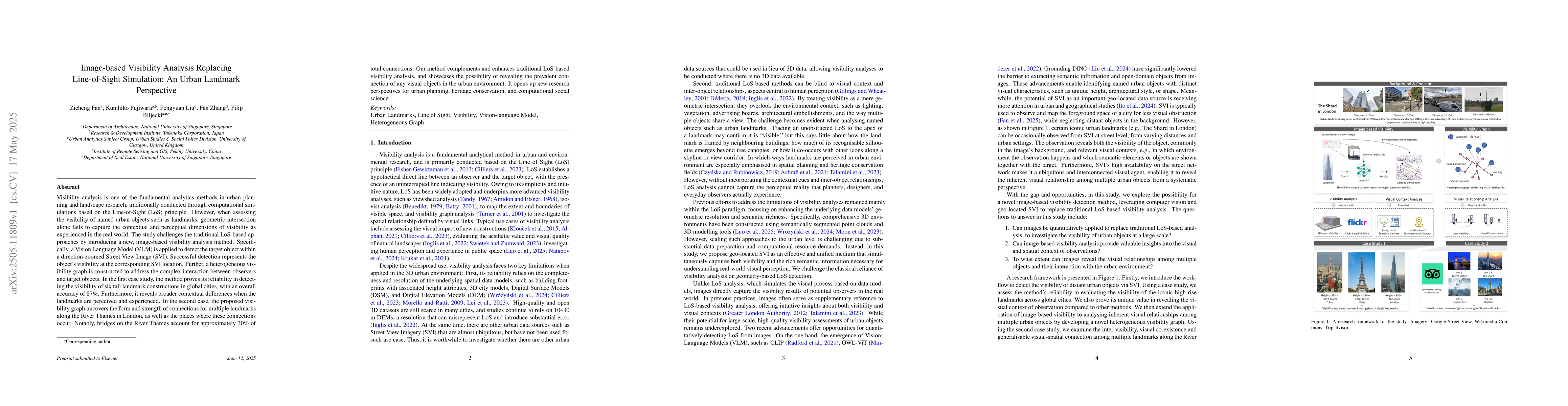
Discussion 0