Increasing SLAM Pose Accuracy by Ground-to-Satellite Image Registration
Publication
Metrics
AI Quick Summary
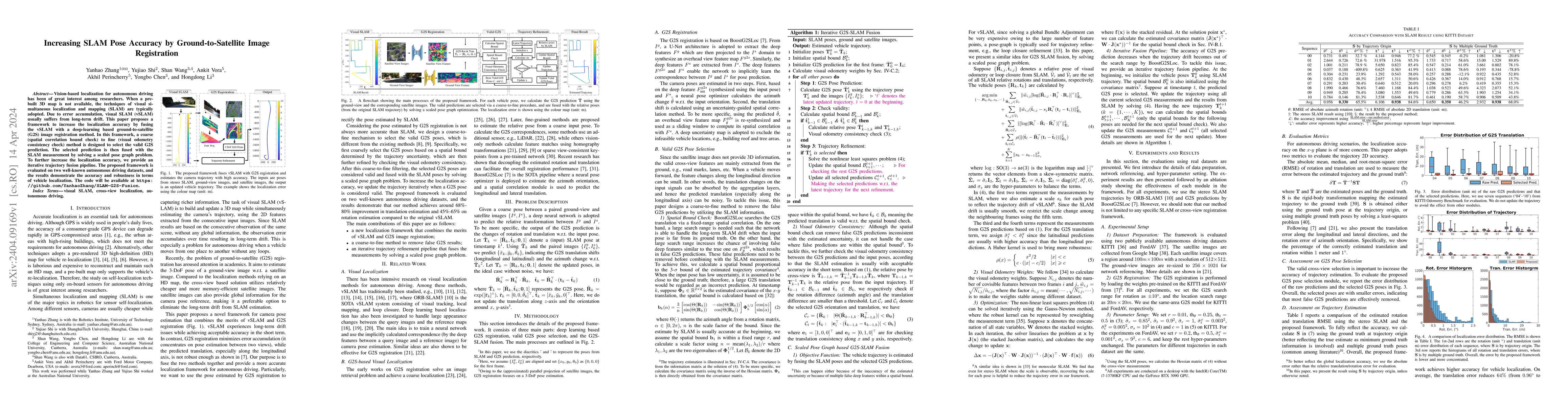
This paper proposes a framework to enhance SLAM pose accuracy by integrating a deep-learning-based ground-to-satellite image registration method to correct drift errors. It uses a coarse-to-fine selection process for valid satellite predictions fused into the SLAM system through an iterative trajectory fusion pipeline, demonstrating improved localization accuracy on autonomous driving datasets.
Paper Preview
Abstract
Vision-based localization for autonomous driving has been of great interest among researchers. When a pre-built 3D map is not available, the techniques of visual simultaneous localization and mapping (SLAM) are typically adopted. Due to error accumulation, visual SLAM (vSLAM) usually suffers from long-term drift. This paper proposes a framework to increase the localization accuracy by fusing the vSLAM with a deep-learning-based ground-to-satellite (G2S) image registration method. In this framework, a coarse (spatial correlation bound check) to fine (visual odometry consistency check) method is designed to select the valid G2S prediction. The selected prediction is then fused with the SLAM measurement by solving a scaled pose graph problem. To further increase the localization accuracy, we provide an iterative trajectory fusion pipeline. The proposed framework is evaluated on two well-known autonomous driving datasets, and the results demonstrate the accuracy and robustness in terms of vehicle localization.
AI Key Findings
Get AI-generated insights about this paper's methodology, results, significance, and more — seven facets brought into focus.
Impact
Paper Details
Authors
PDF Preview
Key Terms
Citation Network
Current paper (gray), citations (green), references (blue)
Display is limited for performance on very large graphs.
Discussion 0