This paper develops a two-stage hierarchical Bayesian model to estimate forest biomass density and total from sparsely sampled LiDAR and georeferenced forest inventory plots in Tanana, Alaska. The model provides stratum-level biomass estimates and compares well with design-based estimates from the USDA Forest Service Forest Inventory and Analysis program.
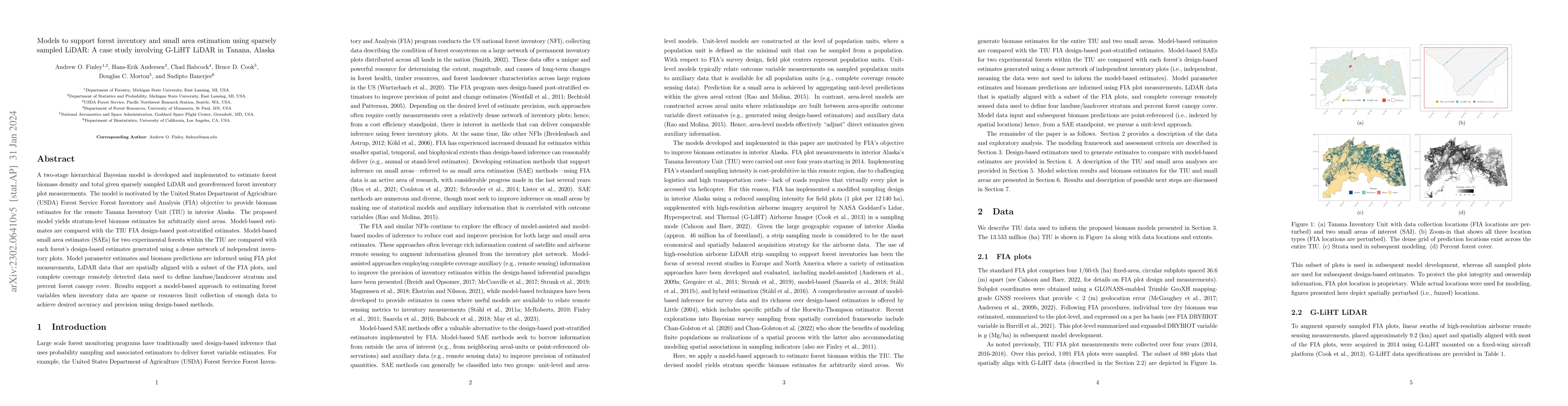
A two-stage hierarchical Bayesian model is developed and implemented to estimate forest biomass density and total given sparsely sampled LiDAR and georeferenced forest inventory plot measurements. The model is motivated by the United States Department of Agriculture (USDA) Forest Service Forest Inventory and Analysis (FIA) objective to provide biomass estimates for the remote Tanana Inventory Unit (TIU) in interior Alaska. The proposed model yields stratum-level biomass estimates for arbitrarily sized areas. Model-based estimates are compared with the TIU FIA design-based post-stratified estimates. Model-based small area estimates (SAEs) for two experimental forests within the TIU are compared with each forest's design-based estimates generated using a dense network of independent inventory plots. Model parameter estimates and biomass predictions are informed using FIA plot measurements, LiDAR data that are spatially aligned with a subset of the FIA plots, and complete coverage remotely detected data used to define landuse/landcover stratum and percent forest canopy cover. Results support a model-based approach to estimating forest variables when inventory data are sparse or resources limit collection of enough data to achieve desired accuracy and precision using design-based methods.
Generated Sep 02, 2025
A two-stage hierarchical Bayesian model was developed and implemented to estimate forest biomass density and total using sparsely sampled LiDAR and georeferenced forest inventory plot measurements in the remote Tanana Inventory Unit (TIU), Alaska.
This research supports a model-based approach to estimating forest variables when inventory data are sparse or resources limit collection of enough data for desired accuracy and precision using design-based methods.
The paper presents a novel two-stage hierarchical Bayesian model that effectively estimates forest biomass using sparse LiDAR data and georeferenced forest inventory plots, providing a solution for remote and data-limited areas.
The model's ability to exploit spatial structure in data and incorporate information from canopy structure sets it apart from traditional design-based inference methods, offering more precise uncertainty quantification for biomass estimation.
Current paper (gray), citations (green), references (blue)
Display is limited for performance on very large graphs.
Grayson W. White, Tracey S. Frescino, Josh K. Yamamoto et al.
Jeffrey W. Doser, Andrew O. Finley, Grant M. Domke et al.
Title | Authors | Year | Actions |
---|
Comments (0)