Patchwork: Concentric Zone-based Region-wise Ground Segmentation with Ground Likelihood Estimation Using a 3D LiDAR Sensor
Publication
Metrics
AI Quick Summary
This paper introduces Patchwork, a novel ground segmentation method for terrestrial mobile platforms using a 3D LiDAR sensor, which employs a Concentric Zone Model and Region-wise Ground Plane Fitting to efficiently segment ground regions, achieving over 40 Hz processing speed and significantly reducing false positives. Experimentally validated on SemanticKITTI and rough terrain datasets, Patchwork outperforms existing plane fitting-based methods.
Paper Preview
Abstract
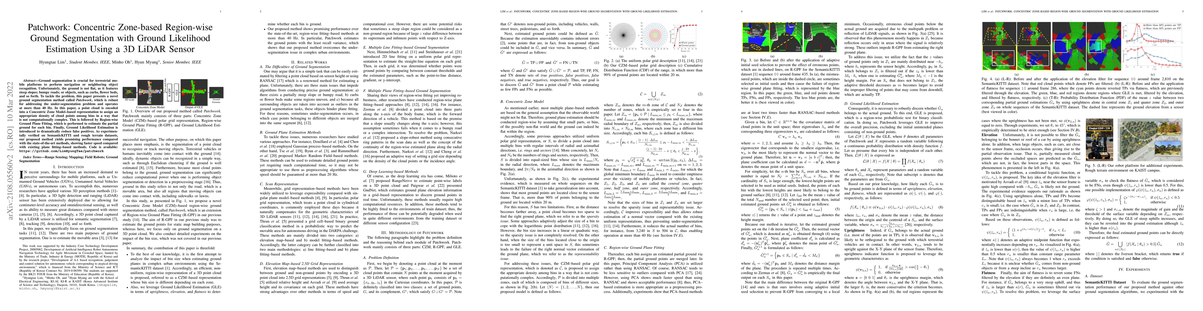
Ground segmentation is crucial for terrestrial mobile platforms to perform navigation or neighboring object recognition. Unfortunately, the ground is not flat, as it features steep slopes; bumpy roads; or objects, such as curbs, flower beds, and so forth. To tackle the problem, this paper presents a novel ground segmentation method called \textit{Patchwork}, which is robust for addressing the under-segmentation problem and operates at more than 40 Hz. In this paper, a point cloud is encoded into a Concentric Zone Model-based representation to assign an appropriate density of cloud points among bins in a way that is not computationally complex. This is followed by Region-wise Ground Plane Fitting, which is performed to estimate the partial ground for each bin. Finally, Ground Likelihood Estimation is introduced to dramatically reduce false positives. As experimentally verified on SemanticKITTI and rough terrain datasets, our proposed method yields promising performance compared with the state-of-the-art methods, showing faster speed compared with existing plane fitting--based methods. Code is available: https://github.com/LimHyungTae/patchwork
AI Key Findings
Get AI-generated insights about this paper's methodology, results, significance, and more — seven facets brought into focus.
Impact
Paper Details
Authors
PDF Preview
Key Terms
Citation Network
Current paper (gray), citations (green), references (blue)
Display is limited for performance on very large graphs.
Discussion 0