Plant detection from ultra high resolution remote sensing images: A Semantic Segmentation approach based on fuzzy loss
Publication
Metrics
AI Quick Summary
This study presents a semantic segmentation approach for identifying plant species in ultra high resolution remote sensing images using a fuzzy loss function to address the challenge of distinguishing plant boundaries. The method employs an RGB dataset with millimeter-level resolution and demonstrates initial results on both a curated dataset and a public one, indicating the effectiveness and potential for further enhancement.
Paper Preview
Abstract
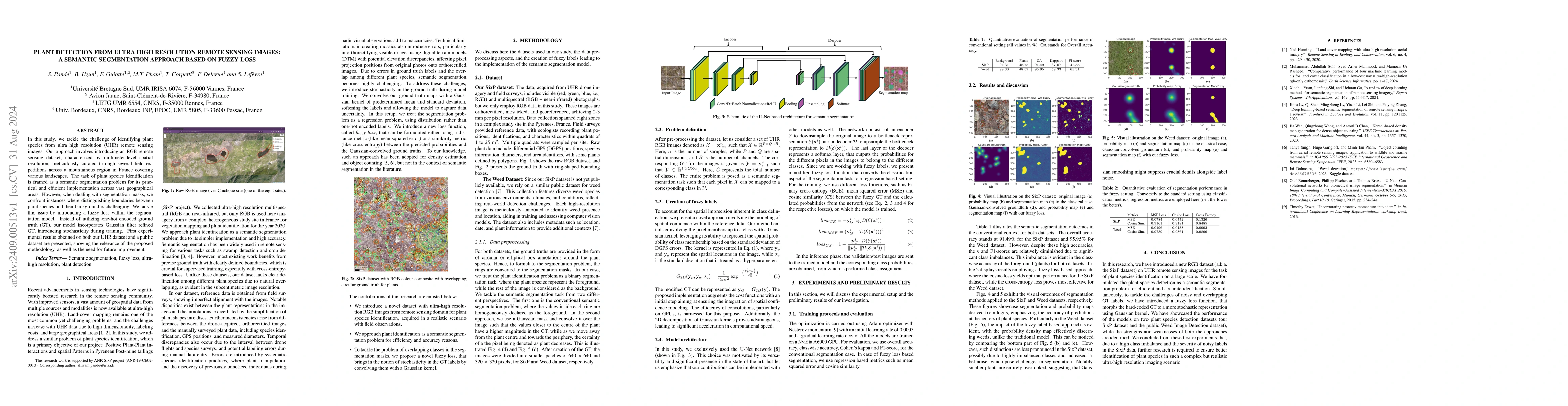
In this study, we tackle the challenge of identifying plant species from ultra high resolution (UHR) remote sensing images. Our approach involves introducing an RGB remote sensing dataset, characterized by millimeter-level spatial resolution, meticulously curated through several field expeditions across a mountainous region in France covering various landscapes. The task of plant species identification is framed as a semantic segmentation problem for its practical and efficient implementation across vast geographical areas. However, when dealing with segmentation masks, we confront instances where distinguishing boundaries between plant species and their background is challenging. We tackle this issue by introducing a fuzzy loss within the segmentation model. Instead of utilizing one-hot encoded ground truth (GT), our model incorporates Gaussian filter refined GT, introducing stochasticity during training. First experimental results obtained on both our UHR dataset and a public dataset are presented, showing the relevance of the proposed methodology, as well as the need for future improvement.
AI Key Findings
Get AI-generated insights about this paper's methodology, results, significance, and more — seven facets brought into focus.
Impact
Paper Details
Authors
PDF Preview
Citation Network
Current paper (gray), citations (green), references (blue)
Display is limited for performance on very large graphs.
Discussion 0