SEN12-WATER: A New Dataset for Hydrological Applications and its Benchmarking
Publication
Metrics
AI Quick Summary
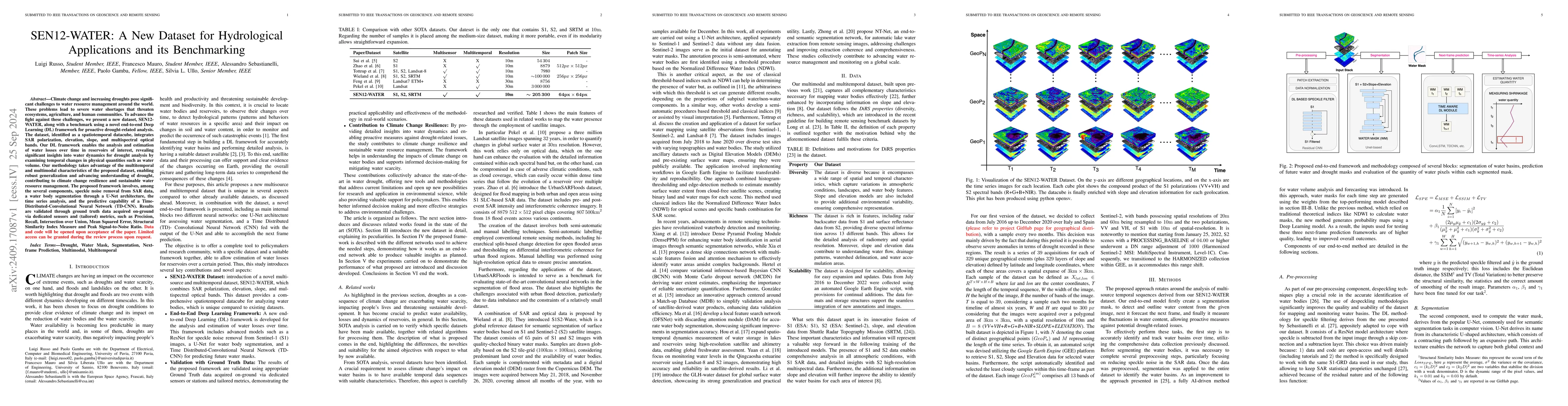
The paper introduces SEN12-WATER, a new spatiotemporal dataset combining SAR, elevation, and optical bands, and presents a Deep Learning framework for analyzing drought-related water loss in reservoirs. The framework, which includes speckle noise removal, U-Net segmentation, time series analysis, and TD-CNN predictions, is validated against ground truth data using various metrics.
Paper Preview
Abstract
Climate change and increasing droughts pose significant challenges to water resource management around the world. These problems lead to severe water shortages that threaten ecosystems, agriculture, and human communities. To advance the fight against these challenges, we present a new dataset, SEN12-WATER, along with a benchmark using a novel end-to-end Deep Learning (DL) framework for proactive drought-related analysis. The dataset, identified as a spatiotemporal datacube, integrates SAR polarization, elevation, slope, and multispectral optical bands. Our DL framework enables the analysis and estimation of water losses over time in reservoirs of interest, revealing significant insights into water dynamics for drought analysis by examining temporal changes in physical quantities such as water volume. Our methodology takes advantage of the multitemporal and multimodal characteristics of the proposed dataset, enabling robust generalization and advancing understanding of drought, contributing to climate change resilience and sustainable water resource management. The proposed framework involves, among the several components, speckle noise removal from SAR data, a water body segmentation through a U-Net architecture, the time series analysis, and the predictive capability of a Time-Distributed-Convolutional Neural Network (TD-CNN). Results are validated through ground truth data acquired on-ground via dedicated sensors and (tailored) metrics, such as Precision, Recall, Intersection over Union, Mean Squared Error, Structural Similarity Index Measure and Peak Signal-to-Noise Ratio.
AI Key Findings
Get AI-generated insights about this paper's methodology, results, significance, and more — seven facets brought into focus.
Impact
Paper Details
Authors
PDF Preview
Citation Network
Current paper (gray), citations (green), references (blue)
Display is limited for performance on very large graphs.
Discussion 0