Sphere2Vec: A General-Purpose Location Representation Learning over a Spherical Surface for Large-Scale Geospatial Predictions
Publication
Metrics
AI Quick Summary
Sphere2Vec is a novel multi-scale location encoder designed to accurately represent points on a spherical surface, preserving spherical distances. It outperforms existing models in geospatial prediction tasks, especially in polar regions and data-sparse areas, due to its ability to mitigate map projection distortions and spherical-to-Euclidean distance approximation errors.
Paper Preview
Abstract
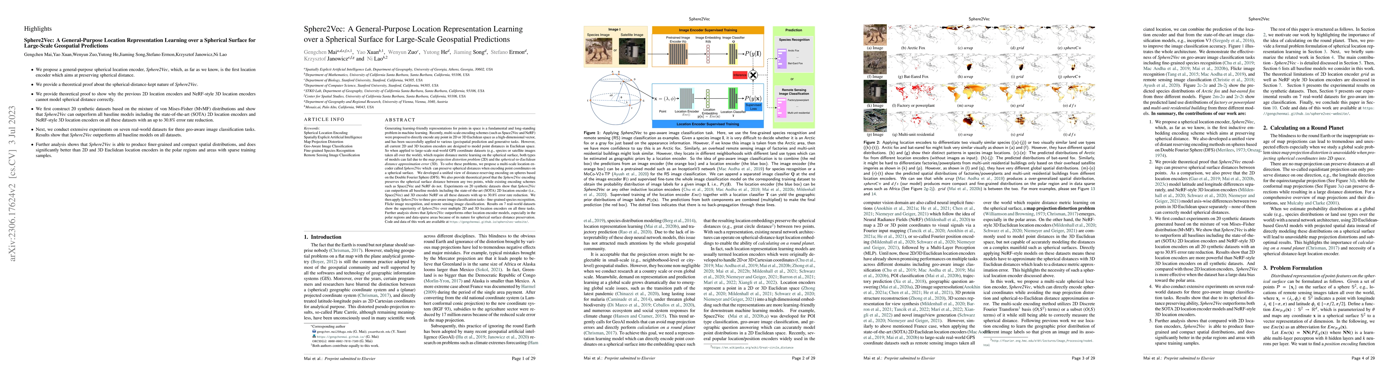
Generating learning-friendly representations for points in space is a fundamental and long-standing problem in ML. Recently, multi-scale encoding schemes (such as Space2Vec and NeRF) were proposed to directly encode any point in 2D/3D Euclidean space as a high-dimensional vector, and has been successfully applied to various geospatial prediction and generative tasks. However, all current 2D and 3D location encoders are designed to model point distances in Euclidean space. So when applied to large-scale real-world GPS coordinate datasets, which require distance metric learning on the spherical surface, both types of models can fail due to the map projection distortion problem (2D) and the spherical-to-Euclidean distance approximation error (3D). To solve these problems, we propose a multi-scale location encoder called Sphere2Vec which can preserve spherical distances when encoding point coordinates on a spherical surface. We developed a unified view of distance-reserving encoding on spheres based on the DFS. We also provide theoretical proof that the Sphere2Vec preserves the spherical surface distance between any two points, while existing encoding schemes do not. Experiments on 20 synthetic datasets show that Sphere2Vec can outperform all baseline models on all these datasets with up to 30.8% error rate reduction. We then apply Sphere2Vec to three geo-aware image classification tasks - fine-grained species recognition, Flickr image recognition, and remote sensing image classification. Results on 7 real-world datasets show the superiority of Sphere2Vec over multiple location encoders on all three tasks. Further analysis shows that Sphere2Vec outperforms other location encoder models, especially in the polar regions and data-sparse areas because of its nature for spherical surface distance preservation. Code and data are available at https://gengchenmai.github.io/sphere2vec-website/.
AI Key Findings
Get AI-generated insights about this paper's methodology, results, significance, and more — seven facets brought into focus.
Impact
Paper Details
Authors
PDF Preview
Key Terms
Citation Network
Current paper (gray), citations (green), references (blue)
Display is limited for performance on very large graphs.
Discussion 0