Summary

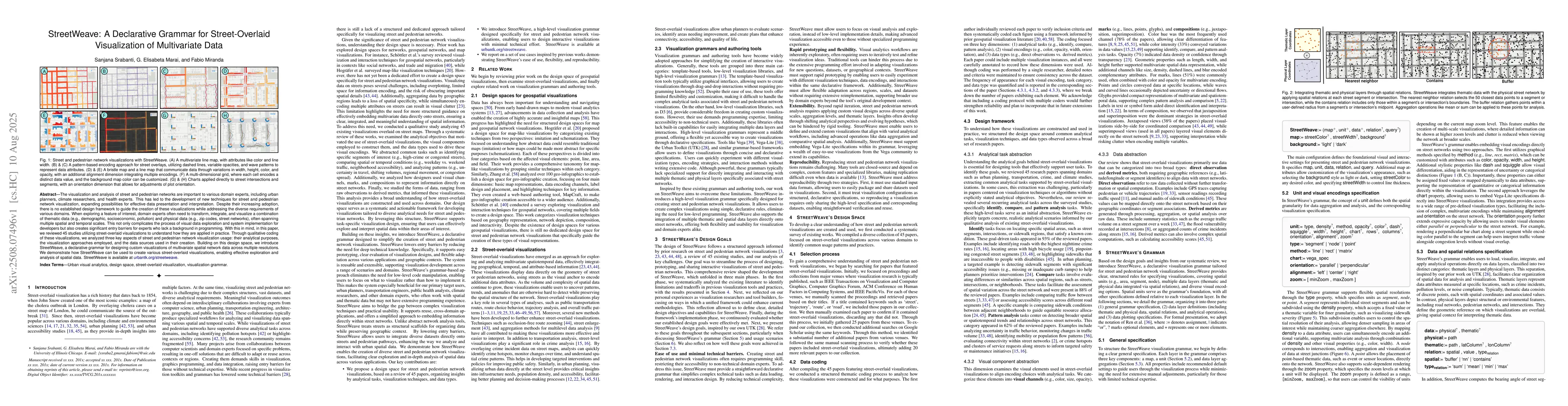
The visualization and analysis of street and pedestrian networks are important to various domain experts, including urban planners, climate researchers, and health experts. This has led to the development of new techniques for street and pedestrian network visualization, expanding how data can be shown and understood more effectively. Despite their increasing adoption, there is no established design framework to guide the creation of these visualizations while addressing the diverse requirements of various domains. When exploring a feature of interest, domain experts often need to transform, integrate, and visualize a combination of thematic data (e.g., demographic, socioeconomic, pollution) and physical data (e.g., zip codes, street networks), often spanning multiple spatial and temporal scales. This not only complicates the process of visual data exploration and system implementation for developers but also creates significant entry barriers for experts who lack a background in programming. With this in mind, in this paper, we reviewed 45 studies utilizing street-overlaid visualizations to understand how they are used. Through qualitative coding of these visualizations, we analyzed three key aspects of street and pedestrian network visualization usage: the analytical purpose they serve, the visualization approaches employed, and the data sources used in their creation. Building on this design space, we introduce StreetWeave, a declarative grammar for designing custom visualizations of multivariate spatial network data across multiple resolutions. We demonstrate how StreetWeave can be used to create various street-overlaid visualizations, enabling effective exploration and analysis of spatial data. StreetWeave is available at https://urbantk.org/streetweave.

AI Key Findings

Generated Aug 14, 2025

Methodology

The paper reviewed 45 studies on street-overlaid visualizations, coding them based on analytical tasks, visualization approaches, and data sources. A declarative grammar, StreetWeave, was developed for designing custom visualizations of multivariate spatial network data.

Key Results

  • StreetWeave identifies three key aspects of street and pedestrian network visualization usage: analytical purpose, visualization approaches, and data sources.
  • StreetWeave supports various analytical tasks, such as identifying, comparing, and pattern analysis, across diverse domains.
  • The paper introduces a design framework for street-overlaid visualizations, focusing on common analytical tasks, visualization techniques, and data types.
  • StreetWeave enables the creation of various street-overlaid visualizations, facilitating effective exploration and analysis of spatial data.

Significance

This research is significant as it addresses the lack of an established design framework for street and pedestrian network visualizations, which are crucial for domain experts in urban planning, climate research, and health.

Technical Contribution

The main technical contribution is the development of StreetWeave, a declarative grammar for designing custom visualizations of multivariate spatial network data across multiple resolutions.

Novelty

StreetWeave's novelty lies in its structured approach to designing street-overlaid visualizations, addressing diverse domain requirements and reducing the entry barrier for non-programmer domain experts.

Limitations

  • The paper acknowledges that including a coding protocol with multiple coders would further strengthen reliability.
  • The review primarily focused on published research papers, potentially overlooking unpublished work or grey literature.

Future Work

  • The authors plan to incorporate multiple coders in future extensions of this work to enhance reliability.
  • They aim to expand the dataset by including unpublished and grey literature to provide a more comprehensive review.

Paper Details

PDF Preview

Download PDF

Similar Papers

Found 4 papers

Comments (0)

This website uses cookies to ensure you get the best experience. Learn more