Publication

Published: Jun 01, 2026
Categories: cs.AI

Metrics

Source: ArXiv

Quick Actions

View PDF

Quick Answers

What methodology did the authors use?

The paper presents a perspective and conceptual framework advocating joint Spatial Representation Learning (SRL) to unify raster perception with vector-based reasoning in geospatial foundation models. It synthesizes existing multimodal geospatial learning efforts, analyzes foundational concepts, articulates technical challenges, and proposes directions for integrating heterogeneous spatial data in a shared embedding space to enable cross-modal alignment between raster patterns and vector... More in Methodology →

What are the key results?

Raster and vector modalities offer complementary information, and unified SRL could enable more accurate and semantically grounded Earth understanding than raster-alone approaches. — Current EOFMs are largely raster-centric and rely on lossy transformations to connect to vector data, which limits cross-modality reasoning and interpretability. More in Key Results →

Why is this work significant?

The work argues for a paradigm shift in geospatial AI toward joint SRL, which is deemed essential for robust, interpretable, and semantically rich models capable of handling complex human-geography interactions and downstream tasks across climate, urban, and disaster domains. More in Significance →

What are the main limitations?

The paper is conceptual and lacks empirical experiments validating unified SRL concepts on real datasets. — Practical challenges such as modality alignment, data quality heterogeneity, and scalable training dynamics are not resolved. More in Limitations →

Paper Preview

Abstract

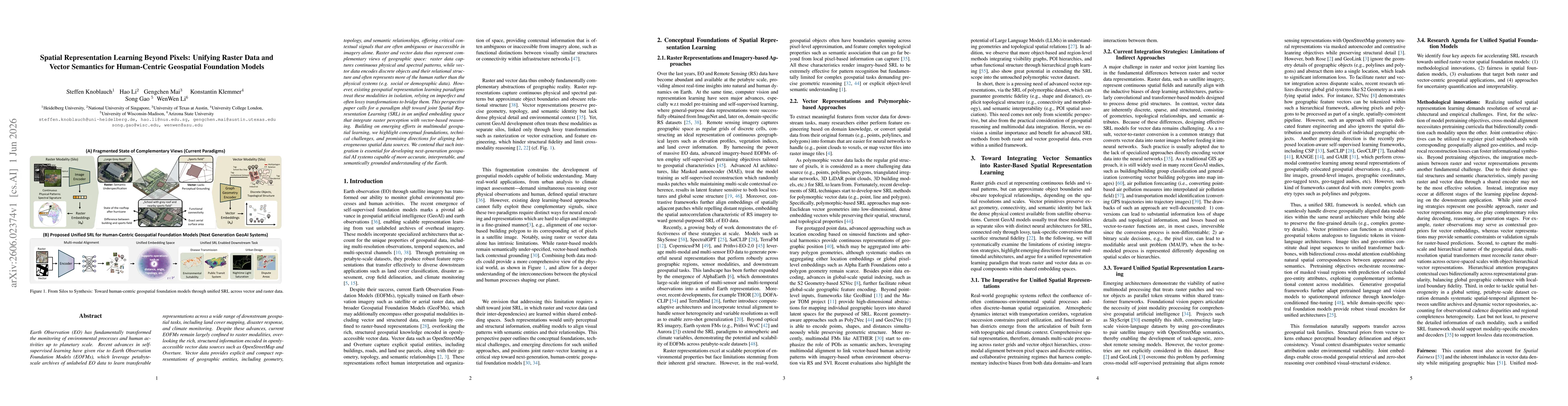
Earth Observation (EO) has fundamentally transformed the monitoring of environmental processes and human activities up to planetary scale. Recent advances in self-supervised learning have given rise to Earth Observation Foundation Models (EOFMs), which leverage petabyte-scale unlabeled EO data to learn transferable representations across a wide range of downstream geospatial tasks. Despite these advances, current EOFMs remain largely confined to raster modalities, overlooking the rich, structured information encoded in openly-accessible vector data sources such as OpenStreetMap and Overture. Vector data provides explicit and compact representations of geographic entities, including geometry, topology, and semantic relationships, offering critical contextual signals that are often ambiguous or inaccessible in imagery alone. Raster and vector data thus represent complementary views of geographic space: raster data captures continuous physical and spectral patterns, while vector data encodes discrete objects and their relational structure and often represents more of the human rather than the physical systems (e.g. social or demographic data). However, existing geospatial representation learning paradigms treat these modalities in isolation, relying on imperfect and often lossy transformations to bridge them. This perspective paper calls for a paradigm shift toward joint Spatial Representation Learning (SRL) in an unified embedding space that integrate raster perception with vector-based reasoning. Building on emerging efforts in multimodal geospatial learning, we highlight conceptual foundations, technical challenges, and promising directions for aligning heterogeneous spatial data sources. We contend that such integration is essential for developing next-generation geospatial AI systems capable of more accurate, interpretable, and semantically grounded understanding of the Earth.

AI Key Findings

Generated Jun 02, 2026

Methodology — What approach did the authors take?

The paper presents a perspective and conceptual framework advocating joint Spatial Representation Learning (SRL) to unify raster perception with vector-based reasoning in geospatial foundation models. It synthesizes existing multimodal geospatial learning efforts, analyzes foundational concepts, articulates technical challenges, and proposes directions for integrating heterogeneous spatial data in a shared embedding space to enable cross-modal alignment between raster patterns and vector entities.

Key Results — What are the main findings?

  • Raster and vector modalities offer complementary information, and unified SRL could enable more accurate and semantically grounded Earth understanding than raster-alone approaches.
  • Current EOFMs are largely raster-centric and rely on lossy transformations to connect to vector data, which limits cross-modality reasoning and interpretability.
  • Bringing raster and vector data into a shared embedding space could align visual patterns with semantic entities and their relationships, enabling holistic geospatial AI systems.

Significance — Why does this research matter?

The work argues for a paradigm shift in geospatial AI toward joint SRL, which is deemed essential for robust, interpretable, and semantically rich models capable of handling complex human-geography interactions and downstream tasks across climate, urban, and disaster domains.

Technical Contribution — What is the technical contribution?

A structured call-to-action and framework outlining how to bridge raster perception and vector-based reasoning within a common embedding space, including identifying conceptual foundations, challenges, and directions for future multimodal geospatial learning.

Novelty — What is new about this work?

Introduces and formalizes the concept of Spatial Representation Learning (SRL) as a unified, cross-modal paradigm for geospatial AI, emphasizing joint integration of raster and vector data beyond existing siloed approaches.

Limitations — What are the limitations of this study?

  • The paper is conceptual and lacks empirical experiments validating unified SRL concepts on real datasets.
  • Practical challenges such as modality alignment, data quality heterogeneity, and scalable training dynamics are not resolved.
  • Evaluation benchmarks for cross-modal geospatial reasoning in a unified embedding space are not established.

Future Work — What did the authors propose for future work?

  • Develop and benchmark unified SRL architectures that jointly learn raster and vector representations in a shared latent space.
  • Create standardized datasets and evaluation protocols for cross-modal geospatial reasoning combining OpenStreetMap, Overtru re, and EO imagery.
  • Investigate interpretability, data fusion strategies, and robust training methods to handle modality gaps and noise.

Paper Details

Paper ID: 2606.02374
Categories:
cs.AI

How to Cite This Paper

BibTeX
@article{knoblauch2026spatial,
  title         = {Spatial Representation Learning Beyond Pixels: Unifying Raster Data and Vector Semantics for Human-Centric Geospatial Foundation Models},
  author        = {Knoblauch, Steffen and Li, Hao and Mai, Gengchen and others},
  year          = {2026},
  eprint        = {2606.02374},
  archivePrefix = {arXiv},
  primaryClass  = {cs.AI},
}
APA 7
Knoblauch, S., Li, H., Mai, G., Klemmer, K., Gao, S., & Li, W. (2026). Spatial Representation Learning Beyond Pixels: Unifying Raster Data and Vector Semantics for Human-Centric Geospatial Foundation Models. arXiv. https://arxiv.org/abs/2606.02374
MLA 9
Knoblauch, Steffen, et al. "Spatial Representation Learning Beyond Pixels: Unifying Raster Data and Vector Semantics for Human-Centric Geospatial Foundation Models." arXiv, 2026, arxiv.org/abs/2606.02374.

Similar Papers

Found 4 papers

Vector-Quantized Vision Foundation Models for Object-Centric Learning

Rongzhen Zhao, Vivienne Wang, Juho Kannala et al.

2025-02-27

Human-Centric Evaluation for Foundation Models

Yijin Guo, Kaiyuan Ji, Xiaorong Zhu et al.

2025-06-02

Comments (0)

This website uses cookies to ensure you get the best experience. Learn more